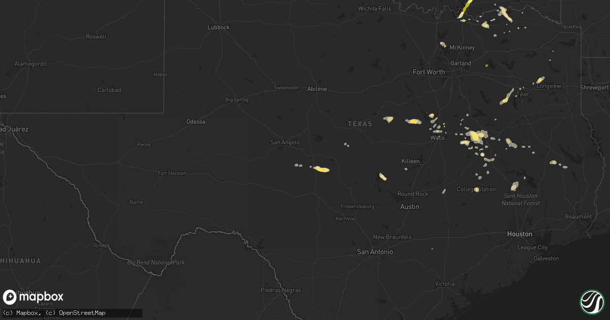
Hail Map in Texas on October 12, 2013
Get this storm
October 12 map
$229
one time, instant access
Download today. No call, no setup
Keep the $229
Bought the map and want the full workflow? Apply the entire $229 to a subscription within 7 days. None of it is wasted.
Every map, not just this one
This buys you this map. Subscription and you get every map we run, in the markets you choose from a few cities to whole states to nationwide. Plus real-time alerts the moment a storm fires.
Contact data
Name, contact info, occupancy, even credit band for addresses in the footprint. You go from where it hit to who to call.
Become the source they trust
Unlimited branding weather history reports on demand. You already have the documented answer ready for the property owner, and you are the one who showed up with it.
Property data and RoofTrace estimates
Pull up any address you have got, its value and the exact code rules for that jurisdiction, straight from One Click Code. Then RoofTrace estimates the squares, pitch, and roof value, priced the way you price.
Storm reports in Texas
Texas
| Date | Description |
|---|---|
| 10/12/20134:56 PM CDT | *** 2 inj *** two trees down...each fell on vehicles. One vehicle had passengers...two were injured. |
| 10/12/20134:55 PM CDT | Reports of trees down in southern madison county. |
| 10/12/20134:38 PM CDT | Roof damage to a barn. Tree down at fish trap and oak rd. Telephone pole down at 5065 hwy 377 cross roads. |
| 10/12/20134:22 PM CDT | Trees down in the hilltop lakes area |
| 10/12/20134:00 PM CDT | Trees down on blackjack street |
| 10/12/20132:42 PM CDT | Gust estimated at 60 mph... 726 and 271 |
| 10/12/20131:46 PM CDT | Power lines down on cr 419 in tyler... Tree down also |
| 10/12/20131:35 PM CDT | Power pole snapped near the high school in clifton. Time estimated. |
| 10/12/20131:15 PM CDT | Trees down throughout houston county. |
Cities Impacted by Hail Map on October 12, 2013
- Nashoba, OK
- Durant, OK
- Mead, OK
- Chandler, TX
- Larue, TX
- Brownsboro, TX
- Murchison, TX
- Athens, TX
- Teague, TX
- Groesbeck, TX
- Mexia, TX
- Donie, TX
- Marquez, TX
- Clifton, TX
- Meridian, TX
- Lufkin, TX
- Huntington, TX
- Tennessee Colony, TX
- West, TX
- Normangee, TX
- Carlton, TX
- Hico, TX
- Dublin, TX
- Hamilton, TX
- Thayer, MO
- Thornton, TX
- Prairie Hill, TX
- Mart, TX
- Kennard, TX
- Apple Springs, TX
- Snow, OK
- Finley, OK
- Rattan, OK
- Brady, TX
- Hext, TX
- Menard, TX
- Naples, TX
- Grayson, LA
- Harrisonburg, LA
- Jonesville, LA
- Bonham, TX
- Dodd City, TX
- Jewett, TX
- Hillsboro, TX
- Whitney, TX
- Columbia, LA
- Kelly, LA
- Olla, LA
- Enterprise, LA
- Colmesneil, TX
- Chester, TX
- Tyler, TX
- Flint, TX
- Gilmer, TX
- Gladewater, TX
- Burnet, TX
- Mason, TX
- China Spring, TX
- Waco, TX
- Aquilla, TX
- Pottsboro, TX
- Denison, TX
- College Station, TX
- Winnfield, LA
- Denton, TX
- Aubrey, TX
- Rochelle, TX
- Coolidge, TX
- Killeen, TX
- Oakwood, TX
- Calhoun, LA
- Bryan, TX
- Bennington, OK
- Honobia, OK
- Buffalo, TX
- Diboll, TX
- Corrigan, TX
- Hugo, OK
- Boswell, OK
- Paris, TX
- Arthur City, TX
- Sumner, TX
- Daingerfield, TX
- Lone Star, TX
- Grandin, MO
- Pattonville, TX
- Wilmot, AR
- Jones, LA
- Crockett, TX
- Grapeland, TX
- Huntsville, TX
- Pointblank, TX
- Centerville, TX
- Big Sandy, TX
- Lonsdale, AR
- Antlers, OK
- Soper, OK
- Fairfield, TX
- Ladonia, TX
- New Waverly, TX
- Eldorado, TX
- Cranfills Gap, TX
- Windom, TX
- Telephone, TX
- Ben Wheeler, TX
- Hamburg, AR
- Oak Grove, LA
- Parkdale, AR
- Detroit, TX
- Deport, TX
- Bogata, TX
- Sherman, TX
- Abbott, TX
- Elm Mott, TX
- Searcy, AR
- Corsicana, TX
- Cooper, TX
- Sicily Island, LA
- North Zulch, TX
- Honey Grove, TX
- Shiner, TX
- Ravenna, TX
- Hendrix, OK
- Dawson, TX
- Brookston, TX
- Little Elm, TX
- Savoy, TX
- Leona, TX
- Axtell, TX
- Rockdale, TX
- Lexington, TX
- Cartwright, OK
- Colbert, OK
- Calera, OK
- Caddo, OK
- Wills Point, TX
- Quinlan, TX
- Ferriday, LA


