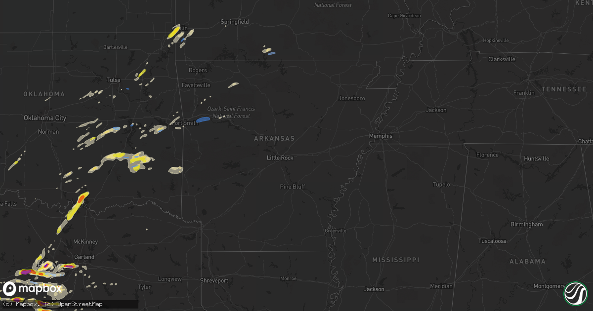
Hail Map in Arkansas on October 10, 2019
Get this storm
October 10 map
$229
one time, instant access
Download today. No call, no setup
Keep the $229
Bought the map and want the full workflow? Apply the entire $229 to a subscription within 7 days. None of it is wasted.
Every map, not just this one
This buys you this map. Subscription and you get every map we run, in the markets you choose from a few cities to whole states to nationwide. Plus real-time alerts the moment a storm fires.
Contact data
Name, contact info, occupancy, even credit band for addresses in the footprint. You go from where it hit to who to call.
Become the source they trust
Unlimited branding weather history reports on demand. You already have the documented answer ready for the property owner, and you are the one who showed up with it.
Property data and RoofTrace estimates
Pull up any address you have got, its value and the exact code rules for that jurisdiction, straight from One Click Code. Then RoofTrace estimates the squares, pitch, and roof value, priced the way you price.
Storm reports in Arkansas
Arkansas
| Date | Description |
|---|---|
| 10/10/20192:24 AM CDT | At 724 PM CDT, severe thunderstorms were located along a line extending from 2 miles south of Mulberry to 8 miles southwest of Ozark to 2 miles northeast of Branch to 5 miles southeast of Charleston, moving east at 30 mph. HAZARD...60 mph wind gusts and nickel size hail. SOURCE...Radar indicated. IMPACT...Expect damage to roofs, siding, and trees. Locations in or near the path include... Ozark... Altus... Branch... Denning... Wiederkehr Village... Jethro... Etna... Barnes... Alix... Redding... Watalula... Meg... Toney... Peter Pender... Cecil... Lonelm... Taft... Cravens... Paradise... This includes Interstate 40 in Arkansas between mile markers 24 and42. |
| 10/10/201912:53 AM CDT | At 553 PM CDT, a severe thunderstorm was located near Lost Valley State Park, or 8 miles west of Jasper, moving northeast at 25 mph. HAZARD...60 mph wind gusts and quarter size hail. SOURCE...Radar indicated. IMPACT...Hail damage to vehicles is expected. Expect wind damage to roofs, siding, and trees. Locations impacted include... Jasper... Erbie... Pruitt... Lost Valley State Park... Upper Buffalo Wilderness Area... Marble Falls... Compton... Ponca... Low Gap... Mt Sherman... Gaither... |
| 10/09/201911:17 PM CDT | At 417 PM CDT, a severe thunderstorm was located near Devils Den State Park, moving northeast at 25 mph. HAZARD...60 mph wind gusts. SOURCE...Radar indicated. IMPACT...Expect damage to roofs, siding, and trees. Locations in or near the path include... West Fork... Winslow... Devils Den State Park... Brentwood... Strickler... Blackburn... Wyola... Sulphur City... Woolsey... Arnett... Hicks... This includes Interstate 49 between mile markers 40 and 54. |
| 10/09/20197:40 PM CDT | Spotter reported thunderstorm winds of 60 to 65 mph with small limbs broken out of live trees. |
Cities Impacted by Hail Map on October 10, 2019
- Aledo, TX
- Fort Worth, TX
- Corsicana, TX
- Bristow, OK
- Smithville, OK
- Thornfield, MO
- Naval Air Station Jrb, TX
- Iredell, TX
- Walnut Springs, TX
- Hico, TX
- Earlsboro, OK
- Mcalester, OK
- Porum, OK
- Eufaula, OK
- Wewoka, OK
- Seminole, OK
- Whitney, TX
- Clifton, TX
- Ranger, TX
- Stephenville, TX
- Dublin, TX
- Kopperl, TX
- Blum, TX
- Grand Prairie, TX
- Keota, OK
- Mccurtain, OK
- Stigler, OK
- China Spring, TX
- Neosho, MO
- Goodman, MO
- Wilburton, OK
- Talihina, OK
- Hartshorne, OK
- Nashoba, OK
- Tuskahoma, OK
- Pittsburg, OK
- Clayton, OK
- Kiowa, OK
- Chouteau, OK
- Pryor, OK
- Wagoner, OK
- Checotah, OK
- Gorman, TX
- De Leon, TX
- Joplin, MO
- Weatherford, TX
- Springtown, TX
- Azle, TX
- Seneca, MO
- Diamond, MO
- Ardmore, OK
- Lipan, TX
- Santo, TX
- Millsap, TX
- Sadler, TX
- Gainesville, TX
- Whitesboro, TX
- Gordonville, TX
- Madill, OK
- Davis, OK
- Sulphur, OK
- Galena, KS
- Quapaw, OK
- Gainesville, MO
- Wasola, MO
- Ada, OK
- Cleburne, TX
- Valley Mills, TX
- Waco, TX
- Eustace, TX
- Dougherty, OK
- Mill Creek, OK
- Blanco, OK
- Coalgate, OK
- Savanna, OK
- Wardville, OK
- Stuart, OK
- Compton, AR
- Combs, AR
- Covington, TX
- Grandview, TX
- Holdenville, OK
- Dustin, OK
- Wetumka, OK
- Hanna, OK
- Kinta, OK
- Quinton, OK
- Ninnekah, OK
- Rush Springs, OK
- McGregor, TX
- Woodway, TX
- Burleson, TX
- Mansfield, TX
- Inola, OK
- Arlington, TX
- Dallas, TX
- Rising Star, TX
- Tolar, TX
- Marlow, OK
- Elkins, AR
- Winslow, AR
- Elm Mott, TX
- Broken Arrow, OK
- West, TX
- Abbott, TX
- Alvarado, TX
- Edwards, MO
- Watson, OK
- Hatfield, AR
- Forreston, TX
- Italy, TX
- Waxahachie, TX
- Morgan, TX
- Durant, OK
- Pottsboro, TX
- Kingston, OK
- Granby, MO
- Sarcoxie, MO
- Snow, OK
- Godley, TX
- Konawa, OK
- Baxter Springs, KS
- Miami, OK
- Meridian, TX
- Seagoville, TX
- Balch Springs, TX
- Mesquite, TX
- Mabank, TX
- Guthrie, OK
- Eden, TX
- Lohn, TX
- Melvin, TX
- Locust Grove, OK
- Tupelo, OK
- Centrahoma, OK
- Maud, OK
- Bowlegs, OK
- Daisy, OK
- Desdemona, TX
- Rocky Mount, MO
- Gravois Mills, MO
- Rich Hill, MO
- Comanche, TX
- Cresson, TX
- Clarksville, AR
- Wyandotte, OK
- Fort Gibson, OK
- Hulbert, OK
- Valley View, TX
- Sanger, TX
- Bluff Dale, TX
- Lincoln, MO
- Stover, MO
- Webb City, MO
- Peggs, OK
- Hillsboro, TX
- Crowley, TX
- Joshua, TX
- Ennis, TX
- Carbon, TX
- Fletcher, OK
- Granbury, TX
- Lawton, OK
- Wilmer, TX
- Lancaster, TX
- Hutchins, TX
- Crawford, TX
- Mounds, OK
- Mingus, TX
- Franklin, TX
- Gordon, TX
- Venus, TX
- Maypearl, TX
- Rio Vista, TX
- Itasca, TX
- Keene, TX
- Milford, TX
- Glen Rose, TX
- Aquilla, TX
- May, TX
- Dawson, TX
- Purdon, TX
- Kellyville, OK
- Justin, TX
- Rhome, TX
- Hartman, AR
- Okemah, OK
- Weleetka, OK
- Rockville, MO
- Sapulpa, OK
- Ferris, TX
- Stroud, OK
- Louisville, IL
- Kemp, TX
- Squires, MO
- Depew, OK
- Collinsville, TX
- Muldrow, OK
- Bynum, TX
- Tishomingo, OK
- Milburn, OK
- Eastland, TX
- Ryan, OK
- Beggs, OK
- Fairland, OK
- Ponca, AR
- Marble Falls, AR
- Adair, OK
- Scurry, TX
- Newark, TX
- Boyd, TX
- Kennedale, TX
- Desoto, TX
- Red Oak, TX
- Chilton, TX
- Roff, OK
- Sallisaw, OK
- Roland, OK
- Gans, OK
- Spiro, OK
- Pocola, OK
- Ponder, TX
- Sasakwa, OK
- Arkoma, OK
- Fort Smith, AR
- Bogata, TX
- Republic, MO
- Haslet, TX
- Hubbard, TX
- Haltom City, TX
- North Richland Hills, TX
- Claremore, OK
- Lake Ozark, MO
- Eldon, MO
- Kaiser, MO
- Cecil, AR
- Lavaca, AR
- Ozark, AR
- Charleston, AR
- Coweta, OK
- Irving, TX


