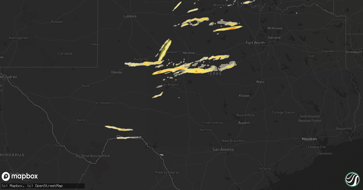
Hail Map in Texas on October 10, 2014
Get this storm
October 10 map
$229
one time, instant access
Download today. No call, no setup
Keep the $229
Bought the map and want the full workflow? Apply the entire $229 to a subscription within 7 days. None of it is wasted.
Every map, not just this one
This buys you this map. Subscription and you get every map we run, in the markets you choose from a few cities to whole states to nationwide. Plus real-time alerts the moment a storm fires.
Contact data
Name, contact info, occupancy, even credit band for addresses in the footprint. You go from where it hit to who to call.
Become the source they trust
Unlimited branding weather history reports on demand. You already have the documented answer ready for the property owner, and you are the one who showed up with it.
Property data and RoofTrace estimates
Pull up any address you have got, its value and the exact code rules for that jurisdiction, straight from One Click Code. Then RoofTrace estimates the squares, pitch, and roof value, priced the way you price.
Storm reports in Texas
Texas
| Date | Description |
|---|---|
| 10/10/20146:55 PM CDT | A local report indicates 1.75 inch wind near 2 NNW NORTON |
| 10/10/20146:55 PM CDT | A local report indicates 1.75 inch wind near ROBERT LEE |
| 10/10/20146:36 PM CDT | A local report indicates 1.00 inch wind near 4 N BRONTE |
| 10/10/20146:31 PM CDT | A local report indicates 1.25 inch wind near BRONTE |
| 10/10/20146:21 PM CDT | A local report indicates 1.00 inch wind near ROTAN |
| 10/10/20146:10 PM CDT | A local report indicates 1.25 inch wind near CHAMPION |
| 10/10/20146:07 PM CDT | A local report indicates 1.00 inch wind near ROBERT LEE |
| 10/10/20145:45 PM CDT | Baseball hail and 65 mph winds reported by so on south side of jacksboro. |
| 10/10/20145:40 PM CDT | Half dollar size hail at highway 380 and highway 199 2 miles south of jacksboro. 3 inch deep hail drifts. |
| 10/10/20145:39 PM CDT | Reported on south side of jacksboro by sheriffs office |
| 10/10/20145:39 PM CDT | Reported on the south side of jacksboro by sheriffs office |
| 10/10/20145:32 PM CDT | A local report indicates 1.25 inch wind near 7 NE GREENWOOD |
| 10/10/20145:27 PM CDT | Broken windshields between bryson and jacksboro |
| 10/10/20145:22 PM CDT | A local report indicates 2.50 inch wind near 8 E STERLING CITY |
| 10/10/20144:46 PM CDT | A local report indicates 1.00 inch wind near 2 NW GRAHAM |
| 10/10/20141:43 AM CDT | The border patrol in langtry reported hail slightly larger than the size of quarters. |
| 10/09/201411:05 PM CDT | 70 mph wind gust in princeton |
| 10/09/201411:02 PM CDT | 544 and us75 |
| 10/09/20149:30 PM CDT | Debris and power lines in the roadway |
| 10/09/20149:25 PM CDT | Trees down blocking roadway along cr 132 approx. 3 nw of morgan mill |
| 10/09/20149:08 PM CDT | Hail broke a window in home |
| 10/09/20149:05 PM CDT | Roof blown off building into street. Several transformers/power lines down and significant dree damage. |
| 10/09/20148:35 PM CDT | A local report indicates 59 MPH wind near 7 NNE BROWNWOOD |
| 10/09/20148:31 PM CDT | A local report indicates 1.00 inch wind near 5 N LAKE BROWNWOOD |
| 10/09/20148:28 PM CDT | A local report indicates 1.00 inch wind near 4 N LAKE BROWNWOOD |
| 10/09/20148:28 PM CDT | A local report indicates 60 MPH wind near 4 N LAKE BROWNWOOD |
| 10/09/20148:20 PM CDT | Trees down along roadway near cr 303 and fm 2683 n of gorman |
| 10/09/20148:20 PM CDT | A local report indicates 1.00 inch wind near 3 NW THRIFTY |
| 10/09/20148:11 PM CDT | Numerous large tree limbs down....telephone poles down...and power lines down. |
| 10/09/20148:05 PM CDT | A local report indicates 1.75 inch wind near COLEMAN |
| 10/09/20148:00 PM CDT | A local report indicates 2.50 inch wind near 1 N COLEMAN |
| 10/09/20147:57 PM CDT | A local report indicates 2.00 inch wind near 1 W COLEMAN |
| 10/09/20147:30 PM CDT | A local report indicates 1.75 inch wind near 1 W WINTERS |
| 10/09/20147:30 PM CDT | Mainly nickel size hail. A few hailstones were to golf ball size. |
| 10/09/20147:00 PM CDT | Quarter to half dollar size hail. |
| 10/09/20147:00 PM CDT | A local report indicates 1.75 inch wind near 3 W WINTERS |
All States Impacted by Hail Map on October 10, 2014
Cities Impacted by Hail Map on October 10, 2014
- Oklahoma City, OK
- Norman, OK
- Newcastle, OK
- Olney, TX
- Newcastle, TX
- Jacksboro, TX
- Bowie, TX
- Hinton, OK
- Minco, OK
- Union City, OK
- El Reno, OK
- Binger, OK
- Midland, TX
- Stanton, TX
- Haskell, TX
- Weinert, TX
- Throckmorton, TX
- Marathon, TX
- Dryden, TX
- Fort Stockton, TX
- Seminole, OK
- Wewoka, OK
- Graham, TX
- Rotan, TX
- Springer, OK
- Jasper, TN
- Guild, TN
- Heavener, OK
- Bryson, TX
- Loving, TX
- Windthorst, TX
- Jermyn, TX
- Maryneal, TX
- Blackwell, TX
- Cullman, AL
- Logan, AL
- Crane Hill, AL
- Arley, AL
- Hanceville, AL
- Tuttle, OK
- Blanchard, OK
- Talpa, TX
- Ballinger, TX
- Pocasset, OK
- Lambert, MS
- Lyon, MS
- Marks, MS
- Wister, OK
- Talihina, OK
- Earlsboro, OK
- Tecumseh, OK
- Munday, TX
- Goree, TX
- Pine Bluff, AR
- Temple, OK
- Waurika, OK
- Wichita Falls, TX
- Randlett, OK
- Hastings, OK
- Hico, TX
- Brownwood, TX
- Santa Anna, TX
- Eastland, TX
- Gorman, TX
- Roosevelt, OK
- Headrick, OK
- Robert Lee, TX
- Sterling City, TX
- Colorado City, TX
- Smithville, OK
- Rising Star, TX
- Carbon, TX
- Cisco, TX
- Mertzon, TX
- Cross Plains, TX
- Hermleigh, TX
- Winters, TX
- Bronte, TX
- Norton, TX
- Miles, TX
- Stephenville, TX
- Seymour, TX
- Comanche, TX
- Dublin, TX
- Desdemona, TX
- Ranger, TX
- Perrin, TX
- Bridgeport, TX
- Chico, TX
- Loraine, TX
- Old Glory, TX
- Big Spring, TX
- Westbrook, TX
- De Leon, TX
- Tishomingo, OK
- Ardmore, OK
- Mill Creek, OK
- Sulphur, OK
- Brookwood, AL
- Ringling, OK
- Nocona, TX
- Belvidere, TN
- Sherwood, TN
- Winchester, TN
- Huntland, TN
- Coleman, TX
- Hodgen, OK
- Holdenville, OK
- Maud, OK
- Garden City, TX
- Chatsworth, GA
- Ellijay, GA
- Gustine, TX
- Paducah, TX
- Siler City, NC
- Vernon, TX
- Roscoe, TX
- Sweetwater, TX
- Roby, TX
- Morganton, NC
- Rochester, TX
- Plainview, AR
- Jessieville, AR
- Crowell, TX
- Bullock, NC
- Henderson, NC
- Henrietta, TX
- Shawnee, OK
- Mcalester, OK
- Krebs, OK
- Lawn, TX
- Goldsboro, TX
- Baird, TX
- Comstock, TX
- Clifton, AZ
- May, TX
- Sidney, TX
- Novice, TX
- Burkett, TX
- Nashoba, OK
- Honobia, OK
- Addison, AL
- Atoka, OK
- Caney, OK
- Knox City, TX
- Rule, TX
- O'Brien, TX
- Dustin, OK
- Nauvoo, AL
- Sheridan, AR
- Grapevine, AR
- Mustang, OK
- Yukon, OK
- Briggsville, AR
- Bluffton, AR
- Bowlegs, OK
- Ozona, TX
- Hatfield, AR
- Cove, AR
- Ryan, OK
- Menard, TX
- Malvern, AR
- Chickamauga, GA
- Rock Spring, GA
- Rising Fawn, GA
- Carrboro, NC
- Chapel Hill, NC
- Clarksdale, MS
- Coahoma, MS
- Deming, NM
- Buckhorn, NM
- Hanna, OK
- Vinemont, AL
- Quinton, AL
- Cordova, AL
- Anadarko, OK
- Gracemont, OK
- Durham, NC
- Pittsboro, NC
- Clyde, TX
- Blanket, TX
- Bangs, TX
- Ovalo, TX
- Early, TX
- Ada, OK
- Wilson, OK
- Wingate, TX
- Eldridge, AL
- Leola, AR
- Tuscola, TX
- Houston, AL
- San Angelo, TX
- Watson, OK
- White Hall, AR
- Clayton, OK
- Carlsbad, TX
- Perryville, AR
- Aspermont, TX
- Harvey, AR
- Gravelly, AR
- Overbrook, OK
- Holly Springs, MS
- Silver City, NM
- Antlers, OK
- Walters, OK
- Carnegie, OK
- Honey Grove, TX
- Sumner, TX
- Brackettville, TX
- Pelham, NC
- Providence, NC
- Danville, VA


