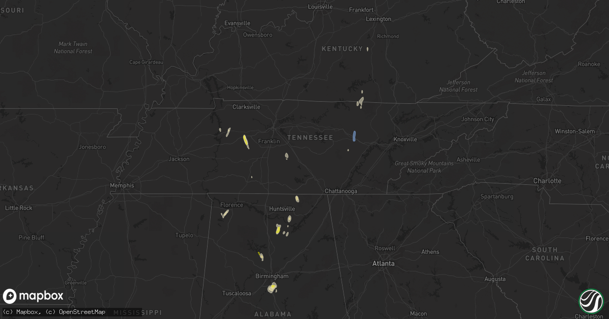
Hail Map in Tennessee on October 6, 2021
Get this storm
October 6 map
$229
one time, instant access
Download today. No call, no setup
Keep the $229
Bought the map and want the full workflow? Apply the entire $229 to a subscription within 7 days. None of it is wasted.
Every map, not just this one
This buys you this map. Subscription and you get every map we run, in the markets you choose from a few cities to whole states to nationwide. Plus real-time alerts the moment a storm fires.
Contact data
Name, contact info, occupancy, even credit band for addresses in the footprint. You go from where it hit to who to call.
Become the source they trust
Unlimited branding weather history reports on demand. You already have the documented answer ready for the property owner, and you are the one who showed up with it.
Property data and RoofTrace estimates
Pull up any address you have got, its value and the exact code rules for that jurisdiction, straight from One Click Code. Then RoofTrace estimates the squares, pitch, and roof value, priced the way you price.
Storm reports in Tennessee
Tennessee
| Date | Description |
|---|---|
| 10/06/20216:53 PM CDT | Trees and powerlines down near hassel creek in the primm springs area of hickman county |
| 10/06/20216:20 PM CDT | A few trees reported down in the rinnie area |
| 10/06/20215:53 PM CDT | Powerlines down and three homes damaged on lawson road north of crossville. |
| 10/06/20215:50 PM CDT | Trees down on tabor loop and lawson road north of crossville |
| 10/06/20215:45 PM CDT | Trees down near the cumberland county community complex on livingston road in crossville |
| 10/06/20216:59 AM CDT | At 1159 AM CDT, a severe thunderstorm was located 10 miles east of Spencer, moving northeast at 15 mph. HAZARD...60 mph wind gusts and penny size hail. SOURCE...Radar indicated. IMPACT...Expect damage to roofs, siding, and trees. Locations impacted include... Crossville, Pleasant Hill, Virgin Falls State Natural Area, Lake Tansi, Indian Rock Lake and Fall Creek Falls State Park. |
| 10/06/20214:04 AM CDT | At 903 PM EDT, a severe thunderstorm was located near Mount Pisgah, or 12 miles northeast of Jamestown, moving northeast at 20 mph. HAZARD...60 mph wind gusts. SOURCE...Radar indicated. IMPACT...Expect damage to roofs, siding, and trees. This severe thunderstorm will be near... Great Meadows Campsites around 915 PM EDT.Other locations in the path of this severe thunderstorm includeParmleysville and Griffin. |
| 10/06/20213:45 AM CDT | At 844 PM EDT, a severe thunderstorm was located 7 miles north of Jamestown, moving north at 20 mph. HAZARD...60 mph wind gusts and penny size hail. SOURCE...Radar indicated. IMPACT...Expect damage to roofs, siding, and trees. Locations impacted include... Sunnybrook, Powersburg and Hidalgo. |
| 10/06/20212:44 AM CDT | At 743 PM CDT, a severe thunderstorm was located near Pall Mall, moving north at 15 mph. HAZARD...60 mph wind gusts. SOURCE...Radar indicated. IMPACT...Expect damage to roofs, siding, and trees. Locations impacted include... Jamestown and Pall Mall. |
| 10/06/20212:12 AM CDT | At 711 PM CDT, a severe thunderstorm was located 8 miles south of Dickson, moving northwest at 25 mph. HAZARD...60 mph wind gusts and quarter size hail. SOURCE...Radar indicated. IMPACT...Hail damage to vehicles is expected. Expect wind damage to roofs, siding, and trees. Locations impacted include... Dickson, Burns, Charlotte, Lyles and Bon Aqua. This includes Interstate 40 between mile markers 163 and 175. |
| 10/06/202112:05 AM CDT | At 504 PM CDT, a severe thunderstorm was located 12 miles north of Shelbyville, moving north at 30 mph. HAZARD...60 mph wind gusts and quarter size hail. SOURCE...Radar indicated. IMPACT...Hail damage to vehicles is expected. Expect wind damage to roofs, siding, and trees. Locations impacted include... Murfreesboro, Smyrna, Walterhill, Christiana, Fosterville and Rockvale.This includes the following highways... Interstate 24 between mile markers 70 and 85. Interstate 840 between mile markers 46 and 58. |
| 10/05/20217:25 PM CDT | Photos showed quarter size hail in the east piney road and will bend road area |
Cities Impacted by Hail Map on October 6, 2021
- Pelham, AL
- Tuscumbia, AL
- Waverly, TN
- McEwen, TN
- Bell Buckle, TN
- Christiana, TN
- Bon Aqua, TN
- Dickson, TN
- Helena, AL
- Alabaster, AL
- Russellville, AL
- Baileyton, AL
- Cullman, AL
- Somerville, AL
- Eva, AL
- Chelsea, AL
- Birmingham, AL
- Pall Mall, TN
- Cherokee, AL
- Bremen, AL
- Empire, AL
- Monticello, KY
- Lyles, TN
- Nunnelly, TN
- Centerville, TN
- Crossville, TN
- Columbiana, AL
- Arab, AL
- Joppa, AL
- Primm Springs, TN
- Duck River, TN
- Shelbyville, TN
- Princeton, AL
- Hollytree, AL
- Rockvale, TN
- Owens Cross Roads, AL
- New Hope, AL
- Stanford, KY
- Ethridge, TN
- Lawrenceburg, TN
- Pikeville, TN
- Blountsville, AL
- Guntersville, AL
- Hurricane Mills, TN
- Union Grove, AL
- Jasper, AL


