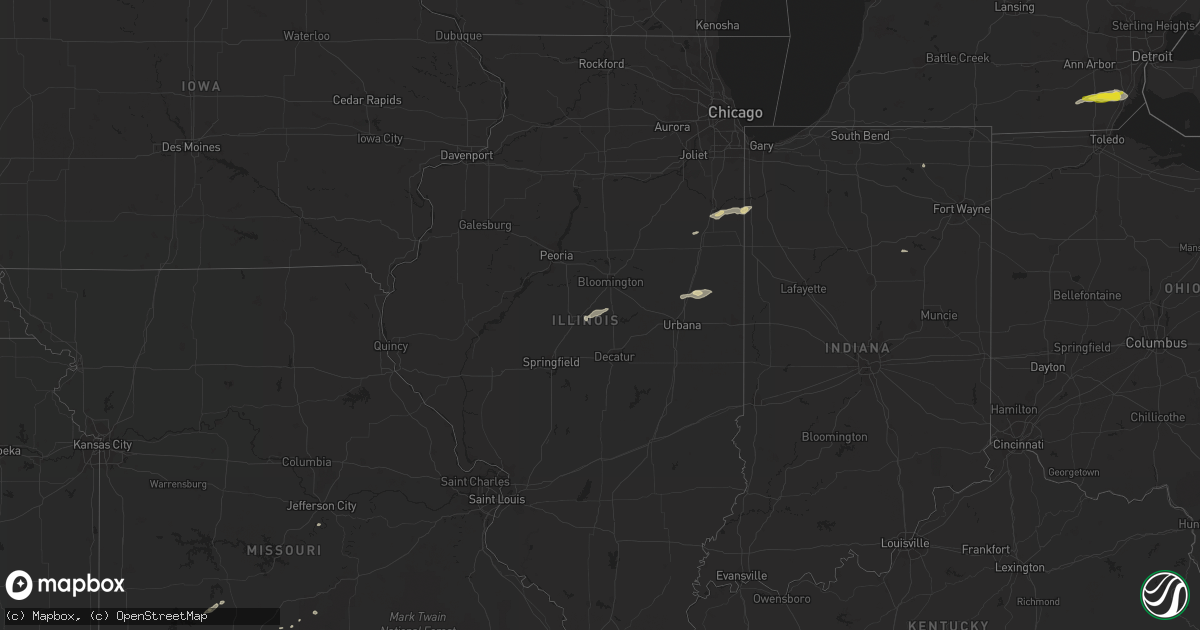
Hail Map in Illinois on October 6, 2018
Get this storm
October 6 map
$229
one time, instant access
Download today. No call, no setup
Keep the $229
Bought the map and want the full workflow? Apply the entire $229 to a subscription within 7 days. None of it is wasted.
Every map, not just this one
This buys you this map. Subscription and you get every map we run, in the markets you choose from a few cities to whole states to nationwide. Plus real-time alerts the moment a storm fires.
Contact data
Name, contact info, occupancy, even credit band for addresses in the footprint. You go from where it hit to who to call.
Become the source they trust
Unlimited branding weather history reports on demand. You already have the documented answer ready for the property owner, and you are the one who showed up with it.
Property data and RoofTrace estimates
Pull up any address you have got, its value and the exact code rules for that jurisdiction, straight from One Click Code. Then RoofTrace estimates the squares, pitch, and roof value, priced the way you price.
Storm reports in Illinois
Illinois
| Date | Description |
|---|---|
| 10/06/20181:45 PM CDT | Reports of power out in rossville and locations northward to hoopeston. |
| 10/06/201812:36 PM CDT | Small limbs reported covering roadway on us-51 in wapella. |
| 10/06/201812:23 PM CDT | Limbs and wires reported down in the city. |
| 10/06/20187:29 AM CDT | At 1227 PM CDT, a severe thunderstorm was located near Waynesville, or 7 miles west of Clinton, moving northeast at 50 mph. HAZARD...60 mph wind gusts. SOURCE...Radar indicated. IMPACT...Expect damage to roofs, siding, and trees. Locations impacted include... Clinton, Le Roy, Heyworth, Farmer City, Wapella, Waynesville, Weldon, Kenney, De Witt, Weldon Springs State Park, Lane, Clinton Lake Dam, Moraine View State Park, Midland City, Rowell and Hallsville.This includes Interstate 74 between mile markers 144 and 157. |
| 10/05/20188:27 PM CDT | At 127 PM CDT, a severe thunderstorm was located near Gifford, or 9 miles southeast of Paxton, moving east at 30 mph. HAZARD...60 mph wind gusts and quarter size hail. SOURCE...Radar indicated. IMPACT...Hail damage to vehicles is expected. Expect wind damage to roofs, siding, and trees. Locations impacted include... Hoopeston, Rossville, Potomac, Rankin, Armstrong and Penfield. |
All States Impacted by Hail Map on October 6, 2018
Cities Impacted by Hail Map on October 6, 2018
- Welch, OK
- Bluejacket, OK
- Batchelor, LA
- Melville, LA
- Half Way, MO
- Bolivar, MO
- Pecos, TX
- Salt Flat, TX
- Mangham, LA
- Rayville, LA
- Alvarado, TX
- Bixby, OK
- Pierce City, MO
- Trout, LA
- Oil City, PA
- Franklin, PA
- Spavinaw, OK
- Loving, NM
- Pryor, OK
- Chouteau, OK
- Lovington, NM
- Scio, NY
- Cuba, NY
- Hinsdale, NY
- Friendship, NY
- Milan, MI
- Monroe, MI
- Maybee, MI
- Carleton, MI
- Dundee, MI
- Newport, MI
- Wilson, OK
- Healdton, OK
- Ringling, OK
- Ardmore, OK
- Springer, OK
- Laquey, MO
- Waynesville, MO
- Atlanta, IL
- Waynesville, IL
- Beason, IL
- Lincoln, IL
- Afton, OK
- Jay, OK
- Eucha, OK
- Chebanse, IL
- Pembroke Township, IL
- Kankakee, IL
- Lake Village, IN
- Saint Anne, IL
- Momence, IL
- Morocco, IN
- Stamford, TX
- Rule, TX
- Haskell, TX
- Ashkum, IL
- Lone Grove, OK
- Throckmorton, TX
- Greensburg, LA
- Carthage, TX
- Jena, LA
- Newcastle, TX
- Tulsa, OK
- Catoosa, OK
- Woodson, TX
- Jonesville, LA
- Long Branch, TX
- Henderson, TX
- Locust Grove, OK
- Gifford, IL
- Ludlow, IL
- Stark City, MO
- Salina, OK
- Inola, OK
- Rankin, IL
- Marksville, LA
- Broken Arrow, OK
- Saint Jo, TX
- Muenster, TX
- Granby, MO
- Georgetown, LA
- Jefferson City, MO
- Saint Thomas, MO
- Simmesport, LA
- Monroe, LA
- Dodson, LA
- Owasso, OK
- Lufkin, TX
- Cooperstown, PA
- Rouseville, PA
- Lebanon, MO
- Overbrook, OK
- Polk, MO
- Dryden, TX
- Ryan, OK
- Graham, TX
- Claremore, OK
- Wabash, IN
- Ligonier, IN
- Jal, NM
- Grovespring, MO
- Okmulgee, OK
- Fordoche, LA
- Morganza, LA
- Dry Prong, LA
- Britton, MI
- Terral, OK
- Brookhaven, MS
- Natchitoches, LA
- Colfax, LA
- Sarcoxie, MO
- Wentworth, MO
- Grove, OK
- Wyandotte, OK
- Davis, OK
- Falcon, MO
- Rantoul, IL
- Penfield, IL
- Paxton, IL
- Black Creek, NY
- Belmont, NY
- Carlsbad, NM
- Roswell, NM


