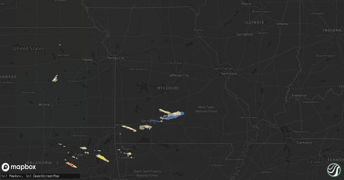
Hail Map in Missouri on October 5, 2019
Get this storm
October 5 map
$229
one time, instant access
Download today. No call, no setup
Keep the $229
Bought the map and want the full workflow? Apply the entire $229 to a subscription within 7 days. None of it is wasted.
Every map, not just this one
This buys you this map. Subscription and you get every map we run, in the markets you choose from a few cities to whole states to nationwide. Plus real-time alerts the moment a storm fires.
Contact data
Name, contact info, occupancy, even credit band for addresses in the footprint. You go from where it hit to who to call.
Become the source they trust
Unlimited branding weather history reports on demand. You already have the documented answer ready for the property owner, and you are the one who showed up with it.
Property data and RoofTrace estimates
Pull up any address you have got, its value and the exact code rules for that jurisdiction, straight from One Click Code. Then RoofTrace estimates the squares, pitch, and roof value, priced the way you price.
Storm reports in Missouri
Missouri
| Date | Description |
|---|---|
| 10/05/20195:46 PM CDT | Texas county dispatch reported multiple trees down near the intersection of highway 17 and highway aa. Time estimated from radar. |
| 10/05/20195:45 PM CDT | Corrects previous tstm wnd dmg report from 1 nw success. Texas county dispatch reported multiple trees down near the intersection of highway 17 and highway m. Time esti |
| 10/05/20194:47 PM CDT | Webster county dispatch reported power lines down in multiple spots along highway 38 southeast of marshfield. Time estimated from radar. |
| 10/05/20194:47 PM CDT | Pictures via social media of multiple large tree limbs down and tree uprooted in a yard along highway 38 eight miles southeast of marshfield. Time estimated from radar. |
| 10/05/201912:32 AM CDT | At 532 PM CDT, severe thunderstorms were located along a line extending from 19 miles northeast of Hartville to 15 miles west of Houston to 10 miles north of Mountain Grove, moving east at 40 mph. HAZARD...60 mph wind gusts and quarter size hail. SOURCE...Radar indicated. IMPACT...Hail damage to vehicles is expected. Expect wind damage to roofs, siding, and trees. Locations impacted include... Licking... Houston... Raymondville... Huggins... Roby... Bucyrus... Hazelton... Prescott... Success... Bendavis... |
| 10/05/201912:03 AM CDT | At 503 PM CDT, severe thunderstorms were located along a line extending from 12 miles east of Niangua to near Hartville to 7 miles north of Mansfield, moving east at 35 mph. HAZARD...60 mph wind gusts and quarter size hail. SOURCE...Radar indicated. IMPACT...Hail damage to vehicles is expected. Expect wind damage to roofs, siding, and trees. Locations impacted include... Dawson... Hartville... Manes... Grovespring... Graff... Odin... |
| 10/04/201911:46 PM CDT | At 446 PM CDT, a severe thunderstorm was located 7 miles southeast of Niangua, or 8 miles east of Marshfield, moving east at 50 mph. HAZARD...60 mph wind gusts and nickel size hail. SOURCE...Radar indicated. IMPACT...Expect damage to roofs, siding, and trees. Locations impacted include... Duncan... Grovespring... |
All States Impacted by Hail Map on October 5, 2019
Cities Impacted by Hail Map on October 5, 2019
- Roanoke, AL
- Franklin, GA
- Claremore, OK
- Collinsville, OK
- Deer Park, AL
- Kellyville, OK
- Beggs, OK
- Bristow, OK
- Fayetteville, AR
- Hindsville, AR
- Elkins, AR
- Konawa, OK
- Thomasville, AL
- Springdale, AR
- Gentry, AR
- Aliceville, AL
- Carrollton, AL
- Plato, MO
- Success, MO
- Bucyrus, MO
- Mountain Grove, MO
- Hartville, MO
- Huggins, MO
- Graff, MO
- Fairfax, OK
- Ralston, OK
- Atwood, OK
- Piedmont, AL
- Wentworth, MO
- Monett, MO
- Pierce City, MO
- Lincolnville, KS
- Coy, AL
- Camden, AL
- Chouteau, OK
- Hulbert, OK
- Locust Grove, OK
- Peggs, OK
- Tahlequah, OK
- Holdenville, OK
- Sasakwa, OK
- Sarcoxie, MO
- Calvin, OK
- Stuart, OK
- Allen, OK
- Niangua, MO
- Conway, MO
- Grovespring, MO
- Phillipsburg, MO
- Clever, MO
- Nixa, MO
- Billings, MO
- Ozark, MO
- Gardendale, AL
- Lowell, AR
- Verona, MO
- Granby, MO
- Diamond, MO
- Bentonville, AR
- Hominy, OK
- Safford, AL
- Orrville, AL
- Kimberly, AL
- Morris, AL
- Warrior, AL
- Decatur, AR
- Anniston, AL
- Selma, AL
- Perkins, OK
- Tryon, OK
- Chatom, AL
- Marshfield, MO
- Seymour, MO
- Tyler, AL
- Skiatook, OK
- Owasso, OK
- Oologah, OK
- Cleveland, OK
- Bowdon, GA
- Roopville, GA
- Siloam Springs, AR
- Catoosa, OK
- Neosho, MO
- Goodman, MO
- Proctor, OK
- Mannford, OK
- Terlton, OK
- Pryor, OK
- Wedowee, AL
- Woodland, AL
- Millry, AL
- Union Church, MS
- Brookhaven, MS
- Lynchburg, MO
- Falcon, MO
- Long Lane, MO
- Wetumpka, AL
- Drumright, OK
- New Augusta, MS
- Richton, MS
- Marionville, MO
- Silas, AL
- Randolph, KS
- Marion, KS
- Frankville, AL
- Brookline, MO
- Sapulpa, OK
- Sand Springs, OK
- Marion Junction, AL
- Catherine, AL
- Aurora, MO
- Crane, MO
- Highlandville, MO
- Burdick, KS
- Cushing, OK
- Tulsa, OK
- Strafford, MO
- Rogersville, MO
- Springfield, MO
- Fordland, MO
- Houston, MO
- Cabool, MO
- Mansfield, MO
- Licking, MO


