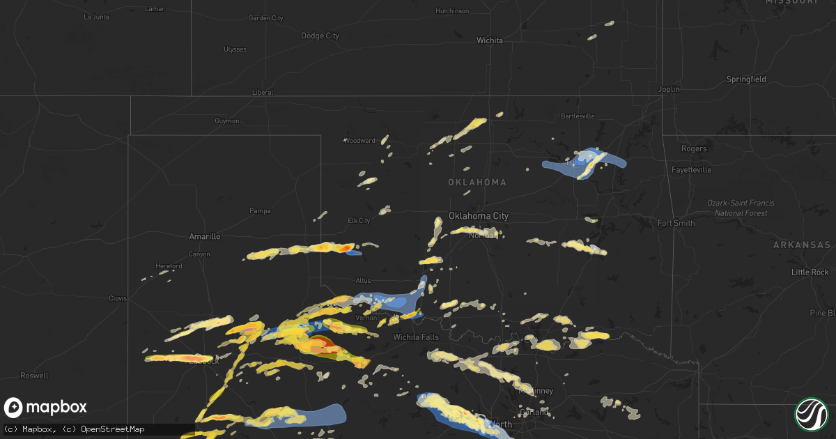
Hail Map in Oklahoma on October 4, 2023
Get this storm
October 4 map
$229
one time, instant access
Download today. No call, no setup
Keep the $229
Bought the map and want the full workflow? Apply the entire $229 to a subscription within 7 days. None of it is wasted.
Every map, not just this one
This buys you this map. Subscription and you get every map we run, in the markets you choose from a few cities to whole states to nationwide. Plus real-time alerts the moment a storm fires.
Contact data
Name, contact info, occupancy, even credit band for addresses in the footprint. You go from where it hit to who to call.
Become the source they trust
Unlimited branding weather history reports on demand. You already have the documented answer ready for the property owner, and you are the one who showed up with it.
Property data and RoofTrace estimates
Pull up any address you have got, its value and the exact code rules for that jurisdiction, straight from One Click Code. Then RoofTrace estimates the squares, pitch, and roof value, priced the way you price.
Storm reports in Oklahoma
Oklahoma
| Date | Description |
|---|---|
| 10/04/20236:45 PM CDT | Report of tree limbs broken and shingles damaged. |
| 10/04/20236:35 PM CDT | Report of significant tree damage. Roof damage to homes. Winds estimated to 80 mph. |
| 10/04/20236:34 PM CDT | Ham radio operator estimated thunderstorm wind gust of 65 mph in mannford. |
| 10/04/20236:04 PM CDT | A local report indicates 1.50 inch wind near 3 SSE Catoosa |
| 10/04/20235:45 PM CDT | Corrects previous tstm wnd dmg report from 2 sw broken arrow. Large tree limb downed onto a house near 88th and 145th in broken arrow. Social media report relayed by br |
| 10/04/20235:45 PM CDT | Privacy fence damaged near 81st and 145th in broken arrow. Time estimated by radar. |
| 10/04/20235:45 PM CDT | Large tree limb... Up to 6 inches in diameter... Broken near 91st and aspen. |
| 10/04/20235:41 PM CDT | A local report indicates 1.25 inch wind near 1 ENE Glenpool |
| 10/04/20235:34 PM CDT | A local report indicates 1.00 inch wind near 3 WNW Bixby |
| 10/04/20234:45 PM CDT | Tree blown over onto car in target parking lot. |
| 10/04/20234:45 PM CDT | Awos station koun norman westheime. |
| 10/04/20234:41 PM CDT | Numerous trees down and county roads blocked. |
| 10/04/20234:40 PM CDT | Numerous trees down near the muddy boggy bridge. |
| 10/04/20234:36 PM CDT | Report of thunderstorm wind gust to 61 mph near intersection of shady grove road and highway 69 northeast of mcalester. |
| 10/04/20234:34 PM CDT | Numerous trees down... County roads blocked. |
| 10/04/20234:25 PM CDT | A local report indicates 1.75 inch wind near 2 NW Newcastle |
| 10/04/20233:49 PM CDT | Em reports collapsed home in frederick. |
| 10/04/20233:41 PM CDT | Em reports barn destroyed near frederick due to tstm wnd dmg. |
| 10/04/20233:38 PM CDT | Frederick asos reporting 85 mph wind gust. |
| 10/04/20233:32 PM CDT | Asos station kfdr frederick altus. |
| 10/04/20233:31 PM CDT | Report of ping pong hail by sheriff. |
| 10/04/20233:27 PM CDT | A local report indicates 80 MPH wind near Hollister |
| 10/04/20233:22 PM CDT | A local report indicates 75 MPH wind near 2.5 N Frederick |
| 10/04/20233:15 PM CDT | 80-90 mph wind report from twitter. |
| 10/04/20233:05 PM CDT | Mesonet station tipt tipton. |
| 10/03/20237:25 PM CDT | Large tree limbs broken. |
| 10/03/20237:24 PM CDT | Report of broken tree limbs... Up to 3 inches in diameter. Also damage to power poles. |
| 10/03/20237:24 PM CDT | Report of tree damage on east side of owasso. |
| 10/03/20237:20 PM CDT | Trees down across 76th st n. |
| 10/03/20237:18 PM CDT | Storm debris noted by owasso pd just south of 86th st n and 129th e ave. |
| 10/03/20237:15 PM CDT | Power lines down across 66th st n. |
| 10/03/20237:14 PM CDT | Tulsa asos measured 66 mph thunderstorm wind gust. |
| 10/03/20237:07 PM CDT | Multiple tree limbs broken. |
| 10/03/20237:05 PM CDT | Social media report of large tree limbs... 4 to 6 inches in diameter... Broken and damaged by strong thunderstorm winds. |
| 10/03/20237:05 PM CDT | Corrects previous tstm wnd dmg report from 2 ssw tulsa. Social media report of large tree limbs... 6 to 8 inches in diameter... Broken and damaged by strong thunderstor |
| 10/03/20237:05 PM CDT | Multiple large tree limbs broken or damaged. Time estimated by radar. |
Cities Impacted by Hail Map on October 4, 2023
- Taloga, OK
- Lamont, OK
- Hunter, OK
- Tonkawa, OK
- Vici, OK
- Camargo, OK
- Leedey, OK
- Ponca City, OK
- Waukomis, OK
- Mooreland, OK
- Chester, OK
- Ringwood, OK
- Meno, OK
- Crescent, OK
- Hennessey, OK
- Marshall, OK
- Carrier, OK
- Lahoma, OK
- Butler, OK
- Isabella, OK
- Enid, OK
- Pond Creek, OK
- Kremlin, OK
- Canyon, TX
- Happy, TX
- Summerfield, TX
- Friona, TX
- Hereford, TX
- Woodward, OK
- Fargo, OK
- Okeene, OK
- Fairmont, OK
- Douglas, OK
- Seiling, OK
- Mutual, OK
- Clarendon, TX
- Hedley, TX
- Quanah, TX
- Paducah, TX
- Floydada, TX
- Quail, TX
- Eldorado, OK
- Wellington, TX
- Shamrock, TX
- Littlefield, TX
- Fort Stockton, TX
- Hale Center, TX
- Roaring Springs, TX
- Hollis, OK
- Erick, OK
- Matador, TX
- Chillicothe, TX
- Willow, OK
- Plainview, TX
- Apache, OK
- Cyril, OK
- Olustee, OK
- Odell, TX
- Vernon, TX
- Elmer, OK
- Balmorhea, TX
- Frederick, OK
- Tipton, OK
- Cement, OK
- Davidson, OK
- Lockney, TX
- Harrold, TX
- Hollister, OK
- Loveland, OK
- Crowell, TX
- Comanche, OK
- Imperial, TX
- Electra, TX
- Devol, OK
- Grandfield, OK
- Chattanooga, OK
- Walters, OK
- Granite, OK
- Lamar, OK
- Mcalester, OK
- Randlett, OK
- Santa Anna, TX
- Rochelle, TX
- Coleman, TX
- Hawley, TX
- Rule, TX
- Abilene, TX
- Anson, TX
- Old Glory, TX
- Clyde, TX
- Stamford, TX
- Crane, TX
- Faxon, OK
- Geronimo, OK
- Cache, OK
- Lawton, OK
- Indianola, OK
- Minco, OK
- Hinton, OK
- Fort Sill, OK
- Elgin, OK
- Lamesa, TX
- Gail, TX
- Morton, TX
- Tuttle, OK
- Newcastle, OK
- Norman, OK
- Odessa, TX
- Boswell, OK
- Hugo, OK
- Arthur City, TX
- Levelland, TX
- Whiteface, TX
- Tahoka, TX
- Odonnell, TX
- Post, TX
- Midland, TX
- Ackerly, TX
- Grant, OK
- Fluvanna, TX
- Seymour, TX
- Lubbock, TX
- Shallowater, TX
- Snyder, TX
- Stanton, TX
- Goree, TX
- Bixby, OK
- Jenks, OK
- Rotan, TX
- Broken Arrow, OK
- Tulsa, OK
- Idalou, TX
- Washington, OK
- Fletcher, OK
- Newalla, OK
- Marlow, OK
- Henryetta, OK
- Eufaula, OK
- Checotah, OK
- Clinton, OK
- Arapaho, OK
- Wheeler, TX
- Sweetwater, OK
- Spur, TX
- Claude, TX
- Holdenville, OK
- Rush Springs, OK
- Binger, OK
- Sentinel, OK
- Hobart, OK
- Lone Wolf, OK
- Blackwell, OK
- Pocasset, OK
- Anadarko, OK
- Burkburnett, TX
- Wewoka, OK
- Bennington, OK
- Cee Vee, TX
- Bokchito, OK
- Maud, OK
- Seminole, OK
- Sheffield, TX
- Mclean, TX
- Loco, OK
- Caddo, OK
- Childress, TX
- Dickens, TX
- Caney, OK
- Dimmitt, TX
- Lorenzo, TX
- Ralls, TX
- Oklahoma City, OK
- Blanchard, OK
- Madill, OK
- El Reno, OK
- Calumet, OK
- Gracemont, OK
- Ropesville, TX
- Lelia Lake, TX
- Duncan, OK
- Healdton, OK
- Wolfforth, TX
- Crosbyton, TX
- Milburn, OK
- Kenefic, OK
- Bowie, TX
- Bowlegs, OK
- Flomot, TX
- Coleman, OK
- Tishomingo, OK
- Durant, OK
- Okarche, OK
- Cashion, OK
- Petersburg, TX
- Waurika, OK
- Montague, TX
- Afton, TX
- Anton, TX
- Hanna, OK
- Wetumka, OK
- Wichita Falls, TX
- Iowa Park, TX
- Temple, OK
- Catoosa, OK
- Hermleigh, TX
- Sweetwater, TX
- Roby, TX
- Lenorah, TX
- Dryden, TX
- Sylvester, TX
- McCaulley, TX
- Hamlin, TX
- Mannford, OK
- Jennings, OK
- Terlton, OK
- Sand Springs, OK
- Sapulpa, OK
- Ozona, TX
- Inola, OK
- Claremore, OK
- Glenpool, OK
- Owasso, OK
- Sperry, OK
- Lueders, TX
- Avoca, TX
- Collinsville, OK
- Graford, TX
- Jacksboro, TX
- Perrin, TX
- Locust Grove, OK
- Pryor, OK
- Chouteau, OK
- Mineral Wells, TX
- Graham, TX
- Bryson, TX
- Millsap, TX
- Weatherford, TX
- Whitt, TX
- Poolville, TX
- Hulbert, OK
- Springtown, TX
- Aledo, TX
- Azle, TX
- Fort Worth, TX
- Crowley, TX
- Naval Air Station Jrb, TX
- Burleson, TX
- Lillian, TX
- Mansfield, TX
- Alvarado, TX
- Kennedale, TX
- Arlington, TX
- Haltom City, TX
- Venus, TX
- Midlothian, TX
- Grand Prairie, TX
- Cedar Hill, TX
- Blum, TX
- Waxahachie, TX
- Cleburne, TX
- Rio Vista, TX
- Grandview, TX
- Covington, TX
- Kopperl, TX
- Nemo, TX
- Whitney, TX
- Hillsboro, TX
- Itasca, TX
- Maypearl, TX
- Milford, TX
- Aquilla, TX
- Italy, TX
- Bynum, TX
- Mertens, TX
- Abbott, TX
- Frost, TX
- Olney, TX
- Holliday, TX
- Mill Creek, OK
- Princeton, TX
- Wylie, TX
- Wolfe City, TX
- Ardmore, OK
- Smyer, TX
- Bellevue, TX
- Whitesboro, TX
- Ratliff City, OK
- Graham, OK
- Springer, OK
- Wilson, OK
- Throckmorton, TX
- Trent, TX
- Tarzan, TX
- Yates Center, KS
- Fredonia, KS
- Buffalo, KS
- Quinton, OK
- Telephone, TX
- Honey Grove, TX
- Sumner, TX
- Noble, OK
- Mounds, OK
- Soper, OK
- Hendrix, OK
- Denison, TX
- Colbert, OK
- Weinert, TX
- Haskell, TX
- Gainesville, TX
- Thackerville, OK
- Ryan, OK
- Valley View, TX
- Muenster, TX
- Era, TX
- Pilot Point, TX
- Rosston, TX
- Forestburg, TX
- Aubrey, TX
- Sanger, TX
- Knox City, TX
- O'Brien, TX
- Kingston, OK
- Celeste, TX
- Frisco, TX
- Mckinney, TX
- Cushing, OK
- Yale, OK
- Henrietta, TX
- Celina, TX
- Prosper, TX
- Loving, TX
- Como, TX
- Sulphur Springs, TX
- Hominy, OK
- Marietta, OK
- Gordonville, TX
- Powderly, TX
- Merkel, TX
- Girard, TX
- Jayton, TX
- Ravenna, TX
- Saint Jo, TX
- Sunset, TX
- Allen, TX
- Little Elm, TX
- Decatur, TX
- Newcastle, TX
- Pottsboro, TX
- Cartwright, OK
- Calera, OK
- Lone Grove, OK
- Iola, KS
- Slaton, TX
- Tecumseh, OK
- Pickton, TX
- Yantis, TX
- Sherman, TX
- Howe, TX
- Rochester, TX
- Mcadoo, TX
- Munday, TX
- Benjamin, TX
- Malone, TX
- Dawson, TX
- Purdon, TX
- Barry, TX
- Blooming Grove, TX
- Ennis, TX
- Corsicana, TX
- Rice, TX
- Forreston, TX
- Richland, TX
- Wortham, TX
- Powell, TX
- Kerens, TX
- Streetman, TX
- Athens, TX
- Trinidad, TX
- Fairfield, TX
- Malakoff, TX
- Tennessee Colony, TX
- Riesel, TX
- Cleveland, MO
- Dallas, TX
- Roscoe, TX
- Rockwall, TX
- Loraine, TX
- Winnsboro, TX
- Stephenville, TX
- Waco, TX
- West, TX
- Irving, TX
- Garland, TX
- Richardson, TX
- Elm Mott, TX
- Royse City, TX
- Chicago, IL
- Carrollton, TX
- Addison, TX
- Eastland, TX
- Cisco, TX
- Ranger, TX
- Clifton, TX
- Peculiar, MO
- Rowlett, TX
- Palmer, TX
- Sonora, TX
- Mount Calm, TX
- Axtell, TX
- Valley Mills, TX
- Leesburg, TX
- Scroggins, TX
- Pittsburg, TX
- Gilmer, TX
- Bison, OK
- Canyon Lake, TX
- New Braunfels, TX
- Seguin, TX
- McQueeney, TX


