Hail Map in Wichita, KS on October 4, 2016
The weather event in Wichita, KS on October 4, 2016 includes Hail map. 5 states and 302 cities were impacted and suffered possible damage. The total estimated number of properties impacted is 3,616.
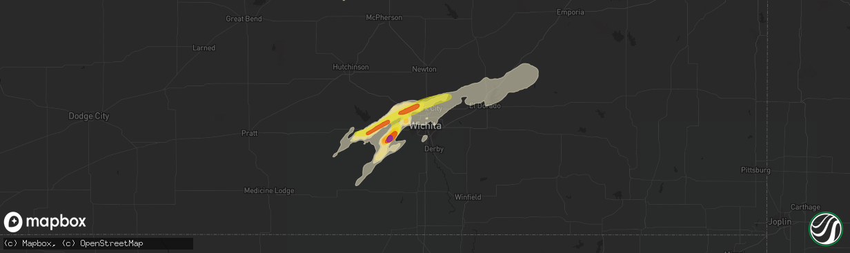
Hail
3,616
Estimated number of impacted properties by a 1.00" hail or larger57
Estimated number of impacted properties by a 1.75" hail or larger0
Estimated number of impacted properties by a 2.50" hail or largerStorm reports in Wichita, KS
Wichita, KS
| Date | Description |
|---|---|
| 10/03/20168:05 PM CDT | Tree fell on house. |
| 10/03/20167:43 PM CDT | Eisenhower national airport. |
| 10/03/20167:30 PM CDT | A local report indicates 65 MPH wind near 3 N WICHITA EISENHOWER |
| 10/03/20167:29 PM CDT | A local report indicates 65 MPH wind near 3 SSW MAIZE |
| 10/03/20167:28 PM CDT | Wind driven half inch diameter hail. |
| 10/03/20167:15 PM CDT | A local report indicates 65 MPH wind near 3 WNW PARK CITY |
All Cities Impacted by Hail Map on October 4, 2016
- Mcloud, OK
- Meeker, OK
- Shidler, OK
- Kaw City, OK
- Bartlesville, OK
- Cedar Vale, KS
- Pawhuska, OK
- Copan, OK
- Newkirk, OK
- Burbank, OK
- Blanchard, OK
- Alex, OK
- Alma, KS
- Wilsey, KS
- Eskridge, KS
- Burrton, KS
- Moundridge, KS
- Allen, KS
- Hillsboro, KS
- Council Grove, KS
- Alta Vista, KS
- Hesston, KS
- Burdick, KS
- Marion, KS
- Lincolnville, KS
- Canton, KS
- Lost Springs, KS
- Newton, KS
- Goessel, KS
- Luther, OK
- Arcadia, OK
- Jones, OK
- Potwin, KS
- Corning, KS
- Table Rock, NE
- Pawnee City, NE
- Wewoka, OK
- Wetumka, OK
- Goddard, KS
- Maize, KS
- Milton, KS
- Cheney, KS
- Benton, KS
- Murdock, KS
- Garden Plain, KS
- Andale, KS
- Colwich, KS
- Wichita, KS
- Viola, KS
- Valley Center, KS
- Clearwater, KS
- Green, KS
- Leonardville, KS
- Blue Rapids, KS
- Randolph, KS
- Waterville, KS
- Barnes, KS
- Wellston, OK
- Seminole, OK
- Okemah, OK
- Abilene, KS
- Perry, OK
- Delphos, KS
- Clay Center, KS
- Miltonvale, KS
- Beverly, KS
- Bennington, KS
- Brookville, KS
- Tescott, KS
- Minneapolis, KS
- Morganville, KS
- Ellsworth, KS
- Longford, KS
- Clifton, KS
- Palmer, KS
- Lincoln, KS
- West Point, NE
- Dodge, NE
- Scribner, NE
- Solomon, KS
- Newcastle, OK
- Tuttle, OK
- Oklahoma City, OK
- Pocasset, OK
- Minco, OK
- Anadarko, OK
- Edmond, OK
- El Dorado, KS
- Henryetta, OK
- Osceola, NE
- Stromsburg, NE
- Bruning, NE
- Carleton, NE
- Strang, NE
- Ohiowa, NE
- Weleetka, OK
- Dustin, OK
- Eureka, KS
- Cassoday, KS
- Castle, OK
- Paden, OK
- Maysville, OK
- Purcell, OK
- Wayne, OK
- Chandler, OK
- Benedict, NE
- Salina, KS
- Belleville, KS
- Cuba, KS
- Morrison, OK
- Red Rock, OK
- Nash, OK
- Medford, OK
- Wakita, OK
- Douglas, OK
- Waukomis, OK
- Fairmont, OK
- Hanover, KS
- Greenleaf, KS
- Cherokee, OK
- Wetmore, KS
- Sabetha, KS
- Checotah, OK
- Eufaula, OK
- Bristow, OK
- Pleasant Dale, NE
- Milford, NE
- Assaria, KS
- Tecumseh, OK
- Holdenville, OK
- Jet, OK
- Enid, OK
- Ames, OK
- Drummond, OK
- Bison, OK
- Dorchester, NE
- Milligan, NE
- Shickley, NE
- Friend, NE
- Tobias, NE
- Dexter, KS
- Maple City, KS
- Riley, KS
- Plymouth, NE
- Swanton, NE
- Western, NE
- Denton, NE
- Lincoln, NE
- Wann, OK
- Lenapah, OK
- Arkansas City, KS
- Norwich, KS
- Argonia, KS
- Oak, NE
- Geneva, NE
- Belvidere, NE
- Crete, NE
- Hebron, NE
- Ruskin, NE
- Davenport, NE
- Raymond, NE
- Deshler, NE
- Alexandria, NE
- Malcolm, NE
- Hardy, NE
- Marquette, KS
- Towanda, KS
- Burns, KS
- Hutchinson, KS
- Haven, KS
- Onaga, KS
- Wakefield, KS
- Kanopolis, KS
- Talmage, KS
- Enterprise, KS
- Lindsborg, KS
- New Cambria, KS
- Geneseo, KS
- Junction City, KS
- Chapman, KS
- Fairbury, NE
- Newalla, OK
- Choctaw, OK
- Harrah, OK
- Silver Creek, NE
- Clarks, NE
- Fremont, NE
- Valley, NE
- Yutan, NE
- Mead, NE
- Dawson, NE
- Verdon, NE
- Milford, KS
- Macomb, OK
- Bradley, OK
- Bellwood, NE
- Shelby, NE
- Rising City, NE
- Braman, OK
- Washington, OK
- Kechi, KS
- Conway Springs, KS
- Vermillion, KS
- York, NE
- Waco, NE
- Earlsboro, OK
- Norman, OK
- Noble, OK
- Shawnee, OK
- Nelson, NE
- Seward, NE
- Gilead, NE
- Munden, KS
- Hubbell, NE
- Chester, NE
- Garber, OK
- Mahaska, KS
- Columbus, NE
- Polk, NE
- Prague, OK
- Sparks, OK
- Lexington, OK
- Gresham, NE
- Bradshaw, NE
- Kingman, KS
- Wanette, OK
- Maud, OK
- Konawa, OK
- Hanna, OK
- Asher, OK
- Lindsay, OK
- Hamburg, IA
- Rock Port, MO
- Riverton, IA
- Henderson, NE
- Kremlin, OK
- Hunter, OK
- Fairview, KS
- Brownville, NE
- Manhattan, KS
- Westmoreland, KS
- Ithaca, NE
- Frankfort, KS
- Gypsum, KS
- Falun, KS
- Harper, KS
- Greenwich, KS
- Whitewater, KS
- Danville, KS
- Stella, NE
- Shubert, NE
- Edgar, NE
- Sylvan Grove, KS
- Linn, KS
- Washington, KS
- Fort Riley, KS
- Marysville, KS
- Olsburg, KS
- Lorraine, KS
- Morrowville, KS
- Little River, KS
- Windom, KS
- Hamilton, KS
- Madison, KS
- Farragut, IA
- Council Bluffs, IA
- Porum, OK
- Caldwell, KS
- Mcpherson, KS
- Galva, KS
- Nemaha, NE
- Reynolds, NE
- De Witt, NE
- Daykin, NE
- Pacific Junction, IA
- Plattsmouth, NE
- Seneca, KS
- Wamego, KS
- Sutton, NE
- Boley, OK
- Depew, OK
- Mustang, OK
- Stroud, OK
- Superior, NE
- Peru, NE
- Auburn, NE
- Watson, MO
- Clyde, KS
- Covington, OK
- Carrier, OK
- Lahoma, OK
- Isabella, OK
- Ringwood, OK
- Hennessey, OK
- Meno, OK
- Wisner, NE
- Blackwell, OK
- Helena, OK
- Carney, OK
- Geuda Springs, KS
- Marland, OK
- Wilson, KS


