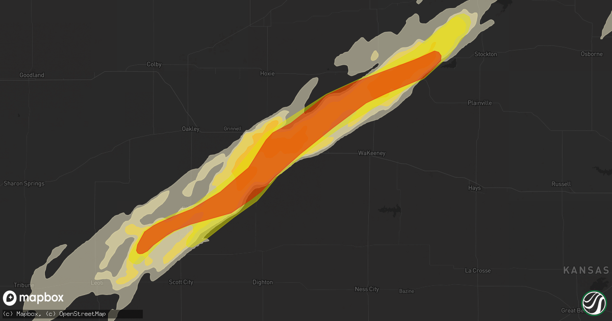
Hail Map in Quinter, KS on October 2, 2017
Get this storm
October 2 map
$229
one time, instant access
Download today. No call, no setup
Keep the $229
Bought the map and want the full workflow? Apply the entire $229 to a subscription within 7 days. None of it is wasted.
Every map, not just this one
This buys you this map. Subscription and you get every map we run, in the markets you choose from a few cities to whole states to nationwide. Plus real-time alerts the moment a storm fires.
Contact data
Name, contact info, occupancy, even credit band for addresses in the footprint. You go from where it hit to who to call.
Become the source they trust
Unlimited branding weather history reports on demand. You already have the documented answer ready for the property owner, and you are the one who showed up with it.
Property data and RoofTrace estimates
Pull up any address you have got, its value and the exact code rules for that jurisdiction, straight from One Click Code. Then RoofTrace estimates the squares, pitch, and roof value, priced the way you price.
Storm reports in Quinter, KS
Quinter, KS
| Date | Description |
|---|---|
| 10/01/20179:40 PM CDT | Significant damage reported on the east side of quinter. A quonset building was destroyed and the roof was peeled back from the city shop building at fifth and long st. |
| 10/01/20178:45 PM CDT | Large tree uprooted and numerous 4 to 6 inch tree branches down across town. |
| 10/01/20178:34 PM CDT | A local report indicates 1.50 inch wind near 5 ESE PARK |
| 10/01/20178:24 PM CDT | Nws damage survey confirms tornado. Delayed lsr. |
| 10/01/20178:24 PM CDT | Reports of uprooted trees and 4 to 6 inch tree branches. In addition...some roofing to a farm structure was blown off. This occurred on the northeast side of quinter. |
All States Impacted by Hail Map on October 2, 2017
All Cities Impacted by Hail Map on October 2, 2017
- Giltner, NE
- Bloomington, NE
- Roseland, NE
- Ayr, NE
- Stratton, NE
- Fulda, MN
- Heron Lake, MN
- Windom, MN
- Jeffers, MN
- Sanborn, MN
- Storden, MN
- Westbrook, MN
- Lamberton, MN
- Morgan, MN
- Clements, MN
- Springfield, MN
- Palisade, NE
- Hayes Center, NE
- Creston, NE
- Columbus, NE
- Saint Libory, NE
- Winnetoon, NE
- Orchard, NE
- Ewing, NE
- Creighton, NE
- Royal, NE
- Clearwater, NE
- Verdigre, NE
- Brunswick, NE
- Grinnell, KS
- Hoxie, KS
- Syracuse, KS
- Kendall, KS
- Lakin, KS
- Leoti, KS
- Trenton, NE
- Culbertson, NE
- Genoa, NE
- Monroe, NE
- Tribune, KS
- McDonald, KS
- Cedar Rapids, NE
- Belgrade, NE
- Clayton, KS
- Norcatur, KS
- Oberlin, KS
- Dresden, KS
- Selden, KS
- Colby, KS
- Rexford, KS
- Jennings, KS
- Leigh, NE
- Stockton, KS
- Marienthal, KS
- Logan, KS
- Damar, KS
- Winona, KS
- Phillipsburg, KS
- Quinter, KS
- Penokee, KS
- Park, KS
- Morland, KS
- Bogue, KS
- Oakley, KS
- Palco, KS
- Collyer, KS
- Hill City, KS
- Scott City, KS
- Grainfield, KS
- Gove, KS
- Glade, KS
- Silver Creek, NE
- Clarks, NE
- Central City, NE
- Platte Center, NE
- Clarkson, NE
- Humphrey, NE
- Wolbach, NE
- Palmer, NE
- Wood River, NE
- Champion, NE
- Wray, CO
- Mankato, KS
- Esbon, KS
- Nelson, NE
- Superior, NE
- Downs, KS
- Burr Oak, KS
- Gaylord, KS
- Callaway, NE
- Oconto, NE
- Broken Bow, NE
- Loup City, NE
- Ravenna, NE
- Ashton, NE
- Rockville, NE
- Hazard, NE
- Washta, IA
- Pierson, IA
- Kingsley, IA
- Doniphan, NE
- Vermillion, SD
- Wynot, NE
- Eustis, NE
- Lenora, KS
- Hastings, NE
- Trumbull, NE
- Smith Center, KS
- Ansley, NE
- Alda, NE
- Grand Island, NE
- Eddyville, NE
- Peterson, IA
- Aurelia, IA
- Linn Grove, IA
- Sioux Rapids, IA
- Larrabee, IA
- Cherokee, IA
- Maywood, NE
- Phillips, NE
- Aurora, NE
- Marquette, NE
- Saint James, MN
- Hanska, MN
- Farwell, NE
- Elba, NE
- Litchfield, NE
- Mason City, NE
- Boelus, NE
- Miller, NE
- Saint Paul, NE
- Moorefield, NE
- Overton, NE
- Farnam, NE
- Pleasanton, NE
- Lexington, NE
- Cozad, NE
- Scotia, NE
- Amherst, NE
- Elwood, NE
- Sumner, NE
- Wakeeney, KS
- Rosalie, NE
- Hampton, NE
- Darfur, MN
- Butterfield, MN
- Saint Paul, MN
- Minneapolis, MN
- Fullerton, NE
- Saint Edward, NE
- Hartington, NE
- Franklin, NE
- Archer, NE
- Madison, NE
- Riverton, NE
- Hordville, NE
- Bladen, NE
- Prairie View, KS
- Howells, NE
- Naponee, NE
- Minden, NE
- Dodge, NE
- Kensington, KS
- Campbell, NE
- Hildreth, NE
- Chapman, NE
- Kirwin, KS
- Agra, KS
- Republican City, NE
- Glenvil, NE
- Inavale, NE
- Kenesaw, NE
- Athol, KS
- Blue Hill, NE
- Holstein, NE
- Lindsay, NE
- Red Cloud, NE
- Juniata, NE
- Healy, KS
- Stanton, NE
- Upland, NE
- Pilger, NE
- Almena, KS
- Marcus, IA
- Sheldon, IA
- Ashton, IA
- Meriden, IA
- Norton, KS
- Axtell, NE
- Wilcox, NE
- Ruthven, IA
- Cleghorn, IA
- New Ulm, MN
- McCook, NE
- Ericson, NE
- Harvard, NE
- Litchfield, MN
- Hutchinson, MN
- Darwin, MN
- Marine On Saint Croix, MN
- Stillwater, MN
- Quimby, IA
- Royal, IA
- Dickens, IA
- Greenville, IA
- Spencer, IA
- Yuma, CO
- Brady, NE
- Westerville, NE
- Redwood Falls, MN
- Buffalo, MN
- Monument, KS
- Anselmo, NE
- Merna, NE
- Seaforth, MN
- Vesta, MN
- Burwell, NE
- Bingham Lake, MN
- Mountain Lake, MN
- Curtis, NE
- Osceola, WI
- Somerset, WI
- Henderson, NE
- Gothenburg, NE
- Akron, CO
- Elyria, NE
- Ord, NE
- Bancroft, NE
- Moville, IA
- Rembrandt, IA
- Webb, IA
- Alta, IA
- Remsen, IA
- Ayrshire, IA
- Gillett Grove, IA
- Clear Lake, WI
- West Point, NE
- Estherville, IA
- Lakeville, MN
- Burnsville, MN
- Prior Lake, MN
- Polk, NE
- Sutherland, NE
- Eckley, CO
- Howard Lake, MN
- Lawton, IA
- Bronson, IA
- Holly, CO
- Milford, IA
- Terril, IA
- George, IA
- Taylor, NE
- Sargent, NE
- Inver Grove Heights, MN
- Graettinger, IA
- Osborne, KS
- Le Sueur, MN
- Saint Peter, MN
- Osceola, NE
- Belview, MN


