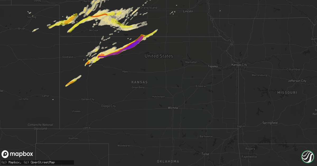
Hail Map in Kansas on October 1, 2017
Get this storm
October 1 map
$229
one time, instant access
Download today. No call, no setup
Keep the $229
Bought the map and want the full workflow? Apply the entire $229 to a subscription within 7 days. None of it is wasted.
Every map, not just this one
This buys you this map. Subscription and you get every map we run, in the markets you choose from a few cities to whole states to nationwide. Plus real-time alerts the moment a storm fires.
Contact data
Name, contact info, occupancy, even credit band for addresses in the footprint. You go from where it hit to who to call.
Become the source they trust
Unlimited branding weather history reports on demand. You already have the documented answer ready for the property owner, and you are the one who showed up with it.
Property data and RoofTrace estimates
Pull up any address you have got, its value and the exact code rules for that jurisdiction, straight from One Click Code. Then RoofTrace estimates the squares, pitch, and roof value, priced the way you price.
Storm reports in Kansas
Kansas
| Date | Description |
|---|---|
| 10/01/20176:57 PM CDT | Brief touchdown of a small rope tornado. |
| 10/01/20176:53 PM CDT | Quarters to golf ball sized hail. |
| 10/01/20176:30 PM CDT | Storm chaser reported a tornado on the ground for approximately one minute. Some tree limbs down. Also had 1.25 inch hail. |
| 10/01/20176:30 PM CDT | Storm chaser reported a tornado on the ground for approximately one minute. Some tree limbs down. Also had 1.25 inch hail. |
| 10/01/20175:56 PM CDT | 2.5 inch hail was reported via social media... Included picture. |
| 10/01/20175:53 PM CDT | Brief weak tornado |
| 10/01/20175:38 PM CDT | Report of 3 inch hail received via social media...included picture. |
| 10/01/20175:38 PM CDT | Tennis ball sized hail reported via social media. |
| 10/01/20175:29 PM CDT | Hail up to 2.25 inch. Us-24 is hail covered and nearly impassable. Reported via social media. |
| 10/01/20175:25 PM CDT | Spotter half mile east and north of hoxie reported 2 inch hail. |
| 10/01/20174:37 PM CDT | Relayed via social media. |
| 10/01/20174:33 PM CDT | Public reports golf ball sized hail at exit 70 on i-70 via social media. |
| 10/01/20174:28 PM CDT | A local report indicates 1.00 inch wind near OAKLEY |
| 10/01/20174:25 PM CDT | Report relayed via social media. |
| 10/01/20174:16 PM CDT | Hail ongoing at time of call. |
| 09/30/20178:08 PM CDT | Storm spotter reported 1.5 inch hail and damage done to some windows at her house. |
| 09/30/20177:59 PM CDT | Picture of hail posted on twitter. |
| 09/30/20177:56 PM CDT | Covering the ground. |
| 09/30/20177:55 PM CDT | 5 east of glade dime to quarter sized hail fell and has covered hwy-9 with 1.5 inches of hail. |
| 09/30/20177:53 PM CDT | Hail covering road and in ditches. Time estimated from radar. |
| 09/30/20177:50 PM CDT | Ping pong ball to egg sized hail. |
| 09/30/20177:49 PM CDT | From twitter. |
| 09/30/20177:40 PM CDT | A local report indicates 2.75 inch wind near AGRA |
All States Impacted by Hail Map on October 1, 2017
Cities Impacted by Hail Map on October 1, 2017
- Sterling, CO
- Steele, ND
- Driscoll, ND
- Tribune, KS
- Penokee, KS
- Bogue, KS
- Stockton, KS
- Gaylord, KS
- Esbon, KS
- Guide Rock, NE
- Morland, KS
- Oak, NE
- Selden, KS
- Oakley, KS
- Hoxie, KS
- Agra, KS
- Logan, KS
- Nelson, NE
- Athol, KS
- Burr Oak, KS
- Lebanon, KS
- Phillipsburg, KS
- Glade, KS
- Hill City, KS
- Red Cloud, NE
- Superior, NE
- Lenora, KS
- Kirwin, KS
- Kensington, KS
- Smith Center, KS
- Broken Bow, NE
- Taylor, NE
- North Platte, NE
- Maywood, NE
- Brady, NE
- Arnold, NE
- Merna, NE
- Sargent, NE
- Brewster, NE
- Hayes Center, NE
- Amelia, NE
- Wallace, NE
- Ewing, NE
- Chambers, NE
- Inman, NE
- Oneill, NE
- Dunning, NE
- Burwell, NE
- Dickens, NE
- Anselmo, NE
- Atkinson, NE
- Gothenburg, NE
- Wellfleet, NE
- Maxwell, NE
- Callaway, NE
- Wilcox, NE
- Alma, NE
- Holdrege, NE
- Orleans, NE
- Leoti, KS
- Gibbon, NE
- Kearney, NE
- McCook, NE
- New Auburn, WI
- Hendley, NE
- Wilsonville, NE
- Beaver City, NE
- Imperial, NE
- Lake Andes, SD
- Armour, SD
- Hildreth, NE
- Bloomington, NE
- Upland, NE
- Campbell, NE
- Ayr, NE
- Holstein, NE
- Roseland, NE
- Bladen, NE
- Wishek, ND
- Lehr, ND
- Wauneta, NE
- Underwood, IA
- Benkelman, NE
- Champion, NE
- Enders, NE
- Lebanon, NE
- Oberlin, KS
- Norcatur, KS
- Stockville, NE
- Farnam, NE
- Oxford, NE
- Cambridge, NE
- Amherst, NE
- Lexington, NE
- Holbrook, NE
- Loomis, NE
- Elwood, NE
- Elm Creek, NE
- Moorefield, NE
- Edison, NE
- Riverdale, NE
- Smithfield, NE
- Arapahoe, NE
- Overton, NE
- Curtis, NE
- Eustis, NE
- Cozad, NE
- Palisade, NE
- Parks, NE
- Bertrand, NE
- Wray, CO
- Yuma, CO
- York, NE
- Page, NE
- Orchard, NE
- Essex, IA
- Shenandoah, IA
- Royal, NE
- Clearwater, NE
- Verdigre, NE
- Creighton, NE
- Winnetoon, NE
- Minden, NE
- Atlanta, NE
- Franklin, NE
- Naponee, NE
- Republican City, NE
- Stamford, NE
- Almena, KS
- Norton, KS
- Akron, CO
- Otis, CO
- Wagner, SD
- Holyoke, CO
- Inavale, NE
- Rexford, KS
- Friend, NE
- Fort Yates, ND
- Carthage, SD
- Elsie, NE
- Dannebrog, NE
- Funk, NE
- Axtell, NE
- Wood River, NE
- Winona, KS
- Shelton, NE
- Grinnell, KS
- Comstock, NE
- Kenesaw, NE
- Colby, KS
- Council Bluffs, IA
- Doniphan, NE
- Crescent, IA
- Johnstown, CO
- Cedar, KS
- Dresden, KS
- Tabor, SD
- Braddock, ND
- Saint Libory, NE
- Saint Paul, NE
- Osceola, NE
- Silver Creek, NE
- Palmer, NE
- Jennings, KS
- Gem, KS
- Fairfax, SD
- Spencer, NE
- Howard, SD
- Ravenna, NE
- Waco, NE
- Beaver Crossing, NE
- Neola, IA
- Granada, CO
- Pleasanton, NE
- Exeter, NE
- Cairo, NE
- Napoleon, ND
- Streeter, ND
- Stuart, NE
- Staplehurst, NE


