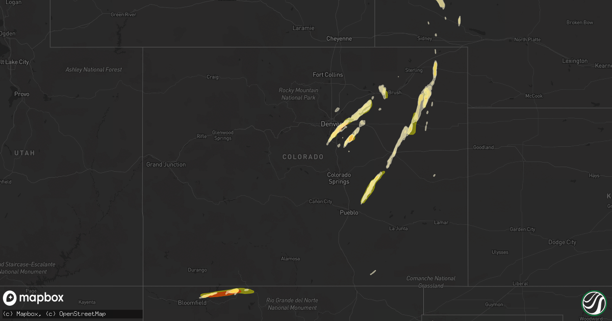
Hail Map in Colorado on September 29, 2014
Get this storm
September 29 map
$229
one time, instant access
Download today. No call, no setup
Keep the $229
Bought the map and want the full workflow? Apply the entire $229 to a subscription within 7 days. None of it is wasted.
Every map, not just this one
This buys you this map. Subscription and you get every map we run, in the markets you choose from a few cities to whole states to nationwide. Plus real-time alerts the moment a storm fires.
Contact data
Name, contact info, occupancy, even credit band for addresses in the footprint. You go from where it hit to who to call.
Become the source they trust
Unlimited branding weather history reports on demand. You already have the documented answer ready for the property owner, and you are the one who showed up with it.
Property data and RoofTrace estimates
Pull up any address you have got, its value and the exact code rules for that jurisdiction, straight from One Click Code. Then RoofTrace estimates the squares, pitch, and roof value, priced the way you price.
Storm reports in Colorado
Colorado
| Date | Description |
|---|---|
| 09/29/20146:44 PM CDT | A local report indicates 76 MPH wind near HUGO |
| 09/29/20146:09 PM CDT | A local report indicates 58 MPH wind near FORT MORGAN |
| 09/29/20146:06 PM CDT | Law enforcement reports a few trees and limbs blown down in town. |
| 09/29/20145:57 PM CDT | A local report indicates 1.00 inch wind near FORT MORGAN |
| 09/29/20145:51 PM CDT | A local report indicates 1.00 inch wind near 2 NW THURMAN |
| 09/29/20144:42 PM CDT | A local report indicates 1.25 inch wind near 1 N OTIS |
| 09/29/20144:30 PM CDT | Power poles down on hwy 79 |
| 09/29/20144:26 PM CDT | A local report indicates 1.25 inch wind near OTIS |
| 09/29/20144:05 PM CDT | A local report indicates 1.00 inch wind near 6 E AURORA |
| 09/29/20144:05 PM CDT | A local report indicates 1.75 inch wind near 7 N ELIZABETH |
| 09/29/20143:58 PM CDT | A local report indicates 1.00 inch wind near BUCKLEY AFB |
| 09/29/20143:55 PM CDT | A local report indicates 1.25 inch wind near 3 ESE AURORA |
| 09/29/20143:51 PM CDT | A local report indicates 1.00 inch wind near 3 W ELIZABETH |
| 09/29/20143:43 PM CDT | A local report indicates 1.25 inch wind near AURORA |
| 09/29/20143:42 PM CDT | A local report indicates 1.50 inch wind near AURORA |
| 09/29/20143:35 PM CDT | A local report indicates 1.25 inch wind near CENTENNIAL |
| 09/29/20143:34 PM CDT | A local report indicates 1.75 inch wind near CENTENNIAL |
| 09/29/20143:33 PM CDT | A local report indicates 1.00 inch wind near CENTENNIAL |
| 09/29/20143:26 PM CDT | A local report indicates 1.00 inch wind near HIGHLANDS RANCH |
| 09/29/20143:20 PM CDT | A local report indicates 1.00 inch wind near 1 SSE HIGHLANDS RANCH |
| 09/29/20142:00 PM CDT | Golf ball size hail reported by at least six people. |
| 09/29/20141:32 PM CDT | Funnel cloud visible for 3 minutes touched the ground for about one minute. No known damage. |
| 09/29/20141:30 PM CDT | Hundreds of trees down in a forest area near county road 302 in eastern archuleta county. Time is approximate. |
| 09/28/20148:40 PM CDT | Several limbs down and a pull behind trailer moved 20 feet. Time estimated by radar. |
| 09/28/20148:12 PM CDT | Fence with 4x4 posts blown down. Tree limbs down. |
| 09/28/20148:11 PM CDT | A local report indicates 76 MPH wind near YUMA |
| 09/28/20148:05 PM CDT | A local report indicates 59 MPH wind near 4 S BURLINGTON |
| 09/28/20147:20 PM CDT | Roof blown off a house. Time estimated by radar. |
| 09/28/20147:10 PM CDT | Measured by a davis weather station. |
| 09/28/20147:08 PM CDT | A local report indicates 60 MPH wind near 6 N WILD HORSE |
All States Impacted by Hail Map on September 29, 2014
Cities Impacted by Hail Map on September 29, 2014
- Corona, NM
- Dulce, NM
- Rush, CO
- Yoder, CO
- Colorado Springs, CO
- Conchas Dam, NM
- Otis, CO
- Aurora, CO
- Ramah, CO
- Limon, CO
- Bridgeport, NE
- Lisco, NE
- Broadwater, NE
- Watkins, CO
- Strasburg, CO
- Roggen, CO
- Wiggins, CO
- Bennett, CO
- Englewood, CO
- Fort Sumner, NM
- Taiban, NM
- Genoa, CO
- Lindon, CO
- Anton, CO
- Fleming, CO
- Haxtun, CO
- Yuma, CO
- Akron, CO
- Solano, NM
- Nara Visa, NM
- Dalhart, TX
- Amistad, NM
- Garita, NM
- Kit Carson, CO
- Cuervo, NM
- Trementina, NM
- Mosquero, NM
- Roswell, NM
- Byers, CO
- Lone Tree, CO
- Littleton, CO
- Navajo Dam, NM
- Parker, CO
- Roy, NM
- Bloomfield, NM
- Castle Rock, CO
- Sedan, NM
- Clayton, NM
- Texline, TX
- Denver, CO
- Louviers, CO
- Ulysses, KS
- Oshkosh, NE
- Franktown, CO
- Elizabeth, CO
- Matheson, CO
- Sedalia, CO
- Vaughn, NM
- Weldona, CO
- Fort Morgan, CO
- Socorro, NM
- Santa Rosa, NM
- Dalton, NE
- Log Lane Village, CO
- Cope, CO
- Boone, CO
- Snyder, CO
- Brighton, CO
- Tierra Amarilla, NM
- Trinidad, CO
- Crook, CO
- Hudson, CO
- Fort Lupton, CO
- Arriba, CO
- Lodgepole, NE
- Thornton, CO
- Commerce City, CO
- Las Vegas, NM
- Yeso, NM
- Kiowa, CO
- Angora, NE


