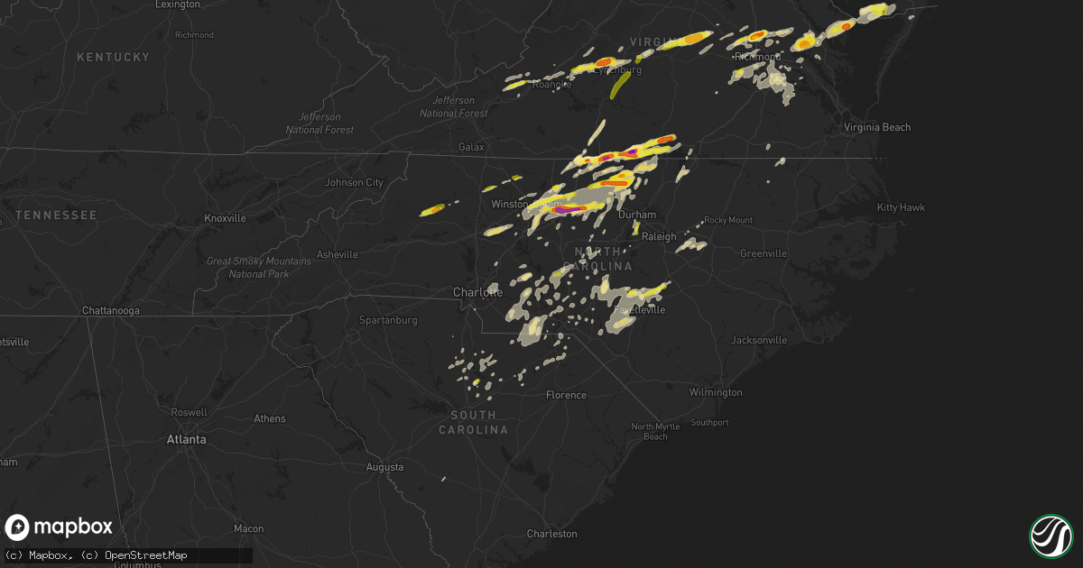
Hail Map in North Carolina on September 28, 2016
Get this storm
September 28 map
$229
one time, instant access
Download today. No call, no setup
Keep the $229
Bought the map and want the full workflow? Apply the entire $229 to a subscription within 7 days. None of it is wasted.
Every map, not just this one
This buys you this map. Subscription and you get every map we run, in the markets you choose from a few cities to whole states to nationwide. Plus real-time alerts the moment a storm fires.
Contact data
Name, contact info, occupancy, even credit band for addresses in the footprint. You go from where it hit to who to call.
Become the source they trust
Unlimited branding weather history reports on demand. You already have the documented answer ready for the property owner, and you are the one who showed up with it.
Property data and RoofTrace estimates
Pull up any address you have got, its value and the exact code rules for that jurisdiction, straight from One Click Code. Then RoofTrace estimates the squares, pitch, and roof value, priced the way you price.
Storm reports in North Carolina
North Carolina
| Date | Description |
|---|---|
| 09/28/20166:45 PM CDT | Hail up to the size of quarters. Report via social media. Time estimated by radar. . |
| 09/28/20166:21 PM CDT | Amateur radio reported trees down in harris off robinson church rd ne of charlotte |
| 09/28/20165:53 PM CDT | . |
| 09/28/20165:53 PM CDT | Hail between quarter and golf ball size on hurdle mills road. |
| 09/28/20165:35 PM CDT | . |
| 09/28/20165:24 PM CDT | A local report indicates 1.00 inch wind near 1 W CAPELLA |
| 09/28/20165:19 PM CDT | Ping pong ball sized hail reported near roxboro. |
| 09/28/20165:14 PM CDT | A local report indicates 1.00 inch wind near MILTON |
| 09/28/20165:10 PM CDT | A local report indicates 1.00 inch wind near 3 SE HIGHTOWERS |
| 09/28/20165:10 PM CDT | . |
| 09/28/20165:03 PM CDT | . |
| 09/28/20165:00 PM CDT | 1 incb hail on i-40 at mile marker 134. . |
| 09/28/20164:36 PM CDT | A local report indicates 1.00 inch wind near BOONVILLE |
| 09/28/20164:25 PM CDT | Golf ball sized hail reported on randleman rd in greensboro. |
| 09/28/20164:05 PM CDT | Nickel to quarter size hail. Report via social media. Time estimated by radar. . |
| 09/28/20163:45 PM CDT | . |
| 09/28/20163:45 PM CDT | Hail nickel to quarter size. . |
| 09/28/20163:37 PM CDT | Pea to quarter size hail near the intersection of highways 61 and 150 ne of greensboro. |
| 09/28/20163:05 PM CDT | A local report indicates 1.00 inch wind near 2 WNW BOOMER |
| 09/28/20162:30 PM CDT | Report via social media. Time estimated by radar. . |
| 09/28/20162:25 PM CDT | Tennis ball size hail reported on mountain hill road. |
| 09/28/20162:15 PM CDT | Time estimated by radar. |
| 09/28/20162:15 PM CDT | . |
| 09/28/20162:07 PM CDT | A local report indicates 1.75 inch wind near 4 SSE DANVILLE CITY |
| 09/28/20162:00 PM CDT | A local report indicates 1.00 inch wind near 4 SSW BETHANY |
| 09/28/20161:46 PM CDT | Hail caused severe damage to an awning on a home. |
| 09/28/20161:45 PM CDT | Quarter size hail was observed along chandler mill road. |
All States Impacted by Hail Map on September 28, 2016
Cities Impacted by Hail Map on September 28, 2016
- Alton, VA
- South Boston, VA
- Virgilina, VA
- Winnsboro, SC
- Chesterfield, VA
- Midlothian, VA
- Moseley, VA
- Chester, VA
- Henrico, VA
- Richmond, VA
- Greensboro, NC
- Cartersville, VA
- Bremo Bluff, VA
- Columbia, VA
- Reidsville, NC
- Eden, NC
- Blackstone, VA
- Rockingham, NC
- Marston, NC
- Rougemont, NC
- Timberlake, NC
- Roxboro, NC
- Wadesboro, NC
- Norwood, NC
- Mount Gilead, NC
- Chase City, VA
- Skipwith, VA
- Manakin Sabot, VA
- Rockville, VA
- Glen Allen, VA
- Yanceyville, NC
- Blanch, NC
- Ewell, MD
- Lumber Bridge, NC
- Lenoir, NC
- Boomer, NC
- Big Island, VA
- Forest, VA
- Coleman Falls, VA
- Lynchburg, VA
- Goode, VA
- Lanexa, VA
- Drewryville, VA
- Branchville, VA
- Boykins, VA
- Cheraw, SC
- Bennettsville, SC
- Society Hill, SC
- Dobson, NC
- Jonesville, NC
- East Bend, NC
- Boonville, NC
- Hamptonville, NC
- Cumberland, VA
- Goochland, VA
- Powhatan, VA
- Baskerville, VA
- Boydton, VA
- Bracey, VA
- Gretna, VA
- Chatham, VA
- Ruffin, NC
- Pelham, NC
- Ringgold, VA
- Danville, VA
- Milton, NC
- Providence, NC
- Cascade, VA
- Sutherlin, VA
- Mascot, VA
- Farnham, VA
- Water View, VA
- Jamaica, VA
- Urbanna, VA
- Heathsville, VA
- Reedville, VA
- Little Plymouth, VA
- Burgess, VA
- Shacklefords, VA
- West Point, VA
- King William, VA
- Center Cross, VA
- Lancaster, VA
- Kilmarnock, VA
- Saluda, VA
- Mattaponi, VA
- Church View, VA
- Stevensville, VA
- King And Queen Court House, VA
- Ridgeway, SC
- Whitsett, NC
- Gibsonville, NC
- McLeansville, NC
- Burlington, NC
- Morven, NC
- Chesterfield, SC
- Ruby, SC
- Peachland, NC
- Marshville, NC
- Polkton, NC
- Mount Croghan, SC
- Bahama, NC
- Wingate, NC
- Mechanicsville, VA
- Hanover, VA
- Ashland, VA
- Manquin, VA
- Red Oak, VA
- Semora, NC
- Clarksville, VA
- Nelson, VA
- Buffalo Junction, VA
- Scottsburg, VA
- Hurdle Mills, NC
- Blacksburg, VA
- Elliston, VA
- Middlesex, NC
- Kenly, NC
- Martinsville, IN
- Bedford, VA
- Hopewell, VA
- Dunn, NC
- Summerfield, NC
- Stokesdale, NC
- Cameron, NC
- Carthage, NC
- Vass, NC
- Southern Pines, NC
- Robbins, NC
- Seagrove, NC
- Bennett, NC
- Thaxton, VA
- Linwood, NC
- Lexington, NC
- Ellerbe, NC
- Candor, NC
- Shannon, NC
- Hillsborough, NC
- Cedar Grove, NC
- Jefferson, SC
- Pageland, SC
- Como, NC
- High Point, NC
- Randleman, NC
- Sophia, NC
- Charles City, VA
- Prince George, VA
- Linden, NC
- Godwin, NC
- Monroe, VA
- Blue Ridge, VA
- Vinton, VA
- Madison Heights, VA
- Amherst, VA
- Montvale, VA
- Leasburg, NC
- Prospect Hill, NC
- Durham, NC
- Cary, NC
- Apex, NC
- Locust, NC
- Mount Pleasant, NC
- Midland, NC
- Graham, NC
- Siler City, NC
- Kannapolis, NC
- Blackstock, SC
- Jackson Springs, NC
- Elon, NC
- Mebane, NC
- Jamestown, NC
- Chester, SC
- Oak Ridge, NC
- Oxford, NC
- Cleveland, NC
- Statesville, NC
- Woodleaf, NC
- Mocksville, NC
- Pittsboro, NC
- Charlotte, NC
- Richfield, NC
- Gold Hill, NC
- Moravian Falls, NC
- Blythewood, SC
- Grant, FL
- Browns Summit, NC
- Winston Salem, NC
- Thomasville, NC
- Kernersville, NC
- Haw River, NC
- Julian, NC
- Colfax, NC
- Roanoke, VA
- Hardy, VA
- Siloam, NC
- Pinnacle, NC
- Salem, VA
- Wagram, NC
- New Hill, NC
- Elgin, SC
- Dillwyn, VA
- Buckingham, VA
- Arvonia, VA
- Scottsville, VA
- New Canton, VA
- Wallace, SC
- Fort Bragg, NC
- Spring Lake, NC
- Fayetteville, NC
- Pope Army Airfield, NC
- Parkton, NC
- Albemarle, NC
- Troy, NC
- Dry Fork, VA
- Red Springs, NC
- Raeford, NC
- Hope Mills, NC
- Stedman, NC
- Wade, NC
- Disputanta, VA
- Liberty, NC
- Climax, NC
- Lancaster, SC
- Heath Springs, SC
- Zebulon, NC
- Providence Forge, VA
- Bullock, NC
- Clemmons, NC
- Pleasant Garden, NC
- Snow Camp, NC
- Efland, NC
- Bishopville, SC
- New London, NC
- Monroe, NC
- Spring Hope, NC
- Walkerton, VA
- Aylett, VA
- King, NC
- Cooleemee, NC
- Advance, NC
- Newport, VA
- Gladstone, VA
- Montpelier, VA
- Doswell, VA
- Hartsville, SC
- Patrick, SC
- New Kent, VA
- Quinton, VA
- Selma, NC
- Clayton, NC
- Middleburg, NC
- Manson, NC
- Norlina, NC
- Henderson, NC
- Radford, VA
- Harrisburg, NC
- Concord, NC
- Great Falls, SC
- Bear Creek, NC
- Richburg, SC
- West End, NC
- Maxton, NC
- Pinehurst, NC
- Aberdeen, NC
- Sanford, NC
- Benson, NC
- Glasgow, VA
- Natural Bridge Station, VA
- Oakboro, NC
- Lugoff, SC
- Christiansburg, VA
- Lucama, NC
- Wendell, NC
- Wilson, NC
- Sims, NC
- Cassatt, SC
- Biscoe, NC
- Camden, SC
- Lilesville, NC
- Pendleton, NC
- Goodview, VA
- Cloverdale, VA
- Troutville, VA
- Pineville, NC
- Fort Mill, SC
- Crozier, VA
- Saint Stephens Church, VA
- Bruington, VA
- Star, NC
- Laurinburg, NC
- Catawba, VA
- North Wilkesboro, NC
- Wilkesboro, NC
- Blackville, SC
- Liberty Hill, SC
- Kershaw, SC
- Wingina, VA
- Spring Grove, VA
- Goldston, NC
- McBee, SC
- Paragon, IN
- Fort Lee, VA
- Gum Spring, VA
- Oilville, VA
- Maidens, VA
- Defuniak Springs, FL
- Inwood, WV
- Bunker Hill, WV
- Gerrardstown, WV
- Waverly, VA
- Colonial Heights, VA
- Sandston, VA
- Petersburg, VA
- Locust Grove, VA
- Bethune, SC
- Madison, NC
- Rich Square, NC
- Walkertown, NC
- Crisfield, MD
- Temperanceville, VA
- Oak Hall, VA
- Atlantic, VA
- Marion Station, MD
- Moncure, NC
- Fork Union, VA
- Howardsville, VA
- Hamlet, NC
- Trinity, NC
- Denton, NC
- Fredericksburg, VA
- Richardsville, VA
- Altavista, VA
- Rustburg, VA
- Evington, VA
- Hurt, VA
- Gladys, VA
- Concord, VA
- Appomattox, VA
- Ferguson, NC
- Morrisville, NC


