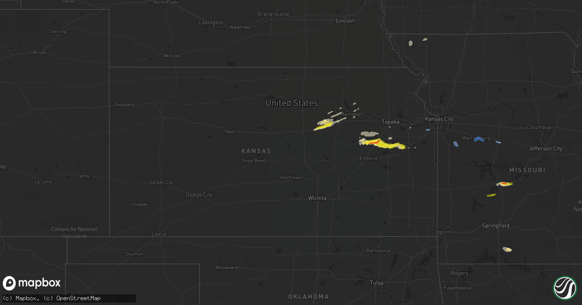
Hail Map in Kansas on September 27, 2020
Get this storm
September 27 map
$229
one time, instant access
Download today. No call, no setup
Keep the $229
Bought the map and want the full workflow? Apply the entire $229 to a subscription within 7 days. None of it is wasted.
Every map, not just this one
This buys you this map. Subscription and you get every map we run, in the markets you choose from a few cities to whole states to nationwide. Plus real-time alerts the moment a storm fires.
Contact data
Name, contact info, occupancy, even credit band for addresses in the footprint. You go from where it hit to who to call.
Become the source they trust
Unlimited branding weather history reports on demand. You already have the documented answer ready for the property owner, and you are the one who showed up with it.
Property data and RoofTrace estimates
Pull up any address you have got, its value and the exact code rules for that jurisdiction, straight from One Click Code. Then RoofTrace estimates the squares, pitch, and roof value, priced the way you price.
Storm reports in Kansas
Kansas
| Date | Description |
|---|---|
| 09/27/202012:09 PM CDT | Via emailed photo. Delayed report. Radar estimated time. |
| 09/27/202012:02 PM CDT | Estimated wind gusts of 60+ mph at 186th and mission rd. |
| 09/27/202011:57 AM CDT | Power pole snapped in half at the intersection of race and hale in spring hill ks. |
| 09/27/202011:51 AM CDT | Observed wind gust at ixd. |
| 09/27/202011:10 AM CDT | A local report indicates 1.00 inch wind near LYNDON |
| 09/27/202011:02 AM CDT | Report from mping: quarter |
| 09/27/202010:56 AM CDT | A local report indicates 1.00 inch wind near 3 WNW OSAGE CITY |
| 09/27/202010:48 AM CDT | A local report indicates 1.25 inch wind near 7 W OSAGE CITY |
| 09/27/202010:44 AM CDT | A local report indicates 1.50 inch wind near 7 NE ADMIRE |
| 09/27/202010:36 AM CDT | A local report indicates 1.25 inch wind near 2 NNW ADMIRE |
| 09/27/202010:29 AM CDT | Relayed from kvoe in emporia. |
| 09/27/20207:44 AM CDT | At 1243 PM CDT, severe thunderstorms were located along a line extending from near Kingsville to near Garden City to 6 miles south of Drexel, moving southeast at 35 mph. HAZARD...60 mph wind gusts. SOURCE...Radar indicated. IMPACT...Expect damage to roofs, siding, and trees. Locations impacted include... Harrisonville, Pleasant Hill, Butler, Holden, Adrian, Garden City, Rich Hill, Archie, Urich, Montrose, Creighton, Chilhowee, East Lynne, Kingsville, Baldwin Park, Amsterdam, Strasburg, Gunn City, Blairstown and Merwin. |
| 09/27/20206:41 AM CDT | At 1141 AM CDT, a severe thunderstorm was located 5 miles southwest of Ottawa, moving east at 40 mph. HAZARD...60 mph wind gusts and quarter size hail. SOURCE...Radar indicated. IMPACT...Hail damage to vehicles is expected. Expect wind damage to roofs, siding, and trees. Locations impacted include... Ottawa, Princeton, Lane and Rantoul. This includes Interstate 35 between mile markers 176 and 192. |
| 09/27/20206:38 AM CDT | At 1138 AM CDT, a severe thunderstorm was located near Abilene, moving northeast at 40 mph. HAZARD...60 mph wind gusts and quarter size hail. SOURCE...Radar indicated. IMPACT...Hail damage to vehicles is expected. Expect wind damage to roofs, siding, and trees. Locations impacted include... Junction City, Abilene, Ogden, Grandview Plaza, Chapman, Enterprise, Milford Lake, Moonlight, Keats and Talmage.This includes Interstate 70 between mile markers 274 and 304. |
| 09/27/20206:05 AM CDT | At 1104 AM CDT, a severe thunderstorm was located near Osage City, moving east at 35 mph. HAZARD...60 mph wind gusts and half dollar size hail. SOURCE...Radar indicated. This storm has a history of producing hail up to the size of ping pong balls. IMPACT...Hail damage to vehicles is expected. Expect wind damage to roofs, siding, and trees. Locations impacted include... Ottawa, Osage City, Lyndon, Pomona, Williamsburg, Quenemo and Melvern.This includes Interstate 35 between mile markers 166 and 180. |
| 09/27/20205:28 AM CDT | At 1028 AM CDT, a severe thunderstorm was located near Bushong, moving east at 35 mph. HAZARD...60 mph wind gusts and half dollar size hail. SOURCE...Radar indicated. IMPACT...Hail damage to vehicles is expected. Expect wind damage to roofs, siding, and trees. Locations impacted include... Osage City, Burlingame, Allen and Admire. This includes Kansas Turnpike between mile markers 144 and 155. |
All States Impacted by Hail Map on September 27, 2020
Cities Impacted by Hail Map on September 27, 2020
- Carbondale, KS
- Scranton, KS
- Junction City, KS
- Chapman, KS
- Wakefield, KS
- Ogden, KS
- Abilene, KS
- Talmage, KS
- Fort Riley, KS
- Riley, KS
- Solomon, KS
- Manhattan, KS
- Bennington, OK
- Shreveport, LA
- Barksdale Afb, LA
- Elm Grove, LA
- Bossier City, LA
- Haughton, LA
- Reading, KS
- Allen, KS
- Osage City, KS
- Tupelo, OK
- Caney, OK
- Atoka, OK
- Wapanucka, OK
- Lyndon, KS
- Pomona, KS
- Quenemo, KS
- Ottawa, KS
- Vassar, KS
- Alma, KS
- Council Grove, KS
- Admire, KS
- Burlingame, KS
- Jefferson, TX
- Dunnellon, FL
- Boswell, OK
- Saint George, KS
- Beverly Hills, FL
- Westmoreland, KS
- Stonewall, OK
- Bradleyville, MO
- Forsyth, MO
- Taneyville, MO
- Preston, MO
- Bivins, TX
- Bogata, TX
- Milford, KS
- Natchitoches, LA
- Macks Creek, MO
- Stratford, OK
- Caddo, OK
- Hugo, OK
- Rantoul, KS
- Deport, TX
- Blossom, TX
- Troup, TX
- Pattonville, TX
- Provencal, LA
- Florien, LA
- Wanette, OK
- Mooringsport, LA
- Belcher, LA
- Lithia, FL
- Sedalia, MO
- Alta Vista, KS
- Naples, TX
- Omaha, TX
- Tarkio, MO
- Fairfax, MO
- Marietta, TX
- Pickering, MO
- Clearmont, MO
- Hopkins, MO
- Paris, TX
- Powderly, TX
- Mount Pleasant, TX
- Detroit, TX
- Eskridge, KS
- Harveyville, KS
- Bolivar, MO
- Topeka, KS
- Coleman, OK
- Hughes Springs, TX
- Ringgold, LA
- Doyline, LA
- Ivanhoe, TX
- Telephone, TX
- Delight, AR
- Dodd City, TX
- Windom, TX
- Honey Grove, TX
- Klondike, TX
- Talco, TX
- Oil City, LA
- Lawrence, KS
- Urbana, MO
- Hermitage, MO
- Yantis, TX
- Ada, OK
- Bokchito, OK
- Durant, OK
- Bonham, TX
- Ravenna, TX
- Olathe, KS
- Mount Vernon, TX
- Winfield, TX
- Garden City, MO
- Harrisonville, MO
- Pleasant Hill, MO
- East Lynne, MO
- Knob Noster, MO
- Whiteman Air Force Base, MO
- Warrensburg, MO
- Humansville, MO
- Dunnegan, MO
- Flemington, MO
- Polk, MO


