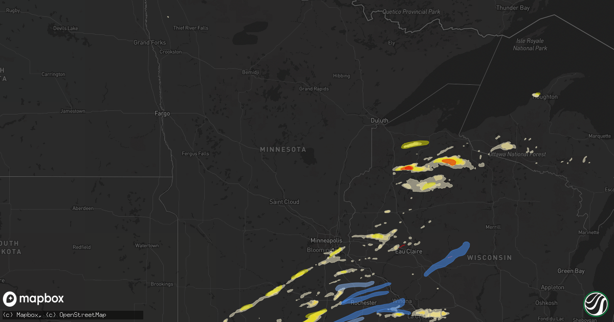
Hail Map in Minnesota on September 24, 2019
Get this storm
September 24 map
$229
one time, instant access
Download today. No call, no setup
Keep the $229
Bought the map and want the full workflow? Apply the entire $229 to a subscription within 7 days. None of it is wasted.
Every map, not just this one
This buys you this map. Subscription and you get every map we run, in the markets you choose from a few cities to whole states to nationwide. Plus real-time alerts the moment a storm fires.
Contact data
Name, contact info, occupancy, even credit band for addresses in the footprint. You go from where it hit to who to call.
Become the source they trust
Unlimited branding weather history reports on demand. You already have the documented answer ready for the property owner, and you are the one who showed up with it.
Property data and RoofTrace estimates
Pull up any address you have got, its value and the exact code rules for that jurisdiction, straight from One Click Code. Then RoofTrace estimates the squares, pitch, and roof value, priced the way you price.
Storm reports in Minnesota
Minnesota
| Date | Description |
|---|---|
| 09/24/20195:52 PM CDT | A local report indicates 1.00 inch wind near MOUNTAIN LAKE |
| 09/24/20193:54 AM CDT | At 853 PM CDT, severe thunderstorms were located along a line extending from near Arcadia to near Dakota, moving northeast at 35 mph. Wind gusts have knocked power out in the Winona Minnesota area as they moved through. Fountain City also reported 60 mph winds. HAZARD...60 mph wind gusts. SOURCE...Trained weather spotters. IMPACT...Expect damage to roofs, siding, and trees. Severe thunderstorms will be near... Arcadia around 900 PM CDT.Other locations impacted by these severe thunderstorms includeHighway 95 And County D, Peacock Hill, Tamarack, Camp Decorah, BeachCorners, Perrot State Park and Frenchville. |
| 09/24/20193:23 AM CDT | At 818 PM CDT, a severe thunderstorm was located near Badger, or 10 miles southwest of Roseau, moving southeast at 40 mph. HAZARD...60 mph wind gusts and quarter size hail. SOURCE...Public. IMPACT...Hail damage to vehicles is expected. Expect wind damage to roofs, siding, and trees. This severe thunderstorm will be near... Malung around 830 PM CDT. Wannaska and Torfin around 835 PM CDT. Pencer and Casperson around 840 PM CDT. Hayes Lake State Park and Skime around 845 PM CDT. |
| 09/24/20193:23 AM CDT | At 822 PM CDT, severe thunderstorms were located along a line extending from near Elgin to Chatfield, moving east at 60 mph. HAZARD...60 mph wind gusts. SOURCE...Trained weather spotters. IMPACT...Expect damage to roofs, siding, and trees. Severe thunderstorms will be near... Altura around 835 PM CDT. Lewiston and Rollingstone around 840 PM CDT. Winona, Goodview, Fountain City and Stockton around 845 PM CDT. Dakota around 905 PM CDT.Other locations impacted by these severe thunderstorms includeWhitewater State Park, Merrick State Park, Czechville, Lock And Dam 5A, Dodge, County Roads 6 And 33 and Wyattville. |
| 09/24/20193:11 AM CDT | At 810 PM CDT, a severe thunderstorm was approaching western Wisconsin, near Wabasha, moving northeast at 50 mph. HAZARD...70 mph wind gusts. SOURCE...Trained weather spotters. IMPACT...Expect considerable tree damage. Damage is likely to mobile homes, roofs, and outbuildings. This severe thunderstorm will be near... Wabasha around 820 PM CDT. Alma around 825 PM CDT. Modena around 835 PM CDT. Mondovi around 845 PM CDT.Other locations impacted by this severe thunderstorm includeGilmanton, Nelson, Waumandee, Maxville, Montana, Cream and MondoviAirfield. |
| 09/24/20192:55 AM CDT | At 754 PM CDT, severe thunderstorms were located along a line extending from Mantorville to near Brownsdale, moving east at 50 mph. HAZARD...60 mph wind gusts. SOURCE...Radar indicated. IMPACT...Expect damage to roofs, siding, and trees. Severe thunderstorms will be near... Byron around 800 PM CDT. Rochester and Stewartville around 810 PM CDT. Eyota and Elgin around 825 PM CDT. Chatfield around 830 PM CDT. Dover around 835 PM CDT.Other locations impacted by these severe thunderstorms include CountyRoads 9 And 10, I 90 Exit 218, County Roads 3 And 108, County Roads 6And 15, Salem Corners, Rock Dell and Rochester Airport. |
| 09/24/20192:48 AM CDT | At 748 PM CDT, a severe thunderstorm was located over Brownsdale, or near Austin, moving east at 50 mph. HAZARD...60 mph wind gusts. SOURCE...Radar indicated. IMPACT...Expect damage to roofs, siding, and trees. This severe thunderstorm will be near... Grand Meadow around 810 PM CDT. Stewartville and Spring Valley around 815 PM CDT. Wykoff around 825 PM CDT.Other locations impacted by this severe thunderstorm includeFillmore, Brookside Campground, Mayville, County Roads 4 And 8,Washington, Waltham and Renova. |
| 09/24/20192:34 AM CDT | At 734 PM CDT, a severe thunderstorm was located near Kenyon, or 14 miles northwest of Mantorville, moving east at 45 mph. HAZARD...70 mph wind gusts. SOURCE...Radar indicated. IMPACT...Expect considerable tree damage. Damage is likely to mobile homes, roofs, and outbuildings. This severe thunderstorm will be near... Wanamingo around 745 PM CDT. Zumbrota around 750 PM CDT. Pine Island and Goodhue around 755 PM CDT. |
| 09/24/20192:17 AM CDT | At 715 PM CDT, a cluster of strong to severe thunderstorms were over central and southern parts of Dodge County, moving east at 55 mph. HAZARD...60 mph wind gusts and penny size hail. SOURCE...Radar indicated. IMPACT...Expect damage to roofs, siding, and trees. This severe thunderstorm will be near... Mantorville and Kasson around 725 PM CDT.Other locations impacted by this severe thunderstorm include CountyRoads 20 And 5, Oslo, Concord, Eden, Highway 57 And 570th Street,County Roads 6 And 15 and County Roads 5 And 6. |
| 09/24/20192:16 AM CDT | At 715 PM CDT, a severe thunderstorm was located near Le Sueur, or 23 miles north of Mankato, moving northeast at 50 mph. HAZARD...Ping pong ball size hail and 60 mph wind gusts. SOURCE...Radar indicated. IMPACT...People and animals outdoors will be injured. Expect hail damage to roofs, siding, windows, and vehicles. Expect wind damage to roofs, siding, and trees. This severe thunderstorm will be near... Belle Plaine around 725 PM CDT. New Prague around 730 PM CDT. Jordan around 735 PM CDT. Shakopee around 750 PM CDT. |
| 09/24/20192:03 AM CDT | At 703 PM CDT, a severe thunderstorm was located over Warsaw, or 7 miles southwest of Faribault, moving east at 40 mph. HAZARD...60 mph wind gusts. SOURCE...Trained weather spotters. IMPACT...Expect damage to roofs, siding, and trees. This severe thunderstorm will be near... Faribault around 710 PM CDT. Medford around 715 PM CDT. Nerstrand around 730 PM CDT. |
| 09/24/20191:56 AM CDT | At 656 PM CDT, severe thunderstorms were located along a line extending from Freeborn to near Ellendale, moving northeast at 60 mph. HAZARD...60 mph wind gusts and half dollar size hail. SOURCE...Radar indicated. IMPACT...Hail damage to vehicles is expected. Expect wind damage to roofs, siding, and trees. Severe thunderstorms will be near... Clarks Grove around 705 PM CDT. Ellendale and Geneva around 710 PM CDT. |
| 09/24/20191:54 AM CDT | At 654 PM CDT, a severe thunderstorm was located 7 miles southeast of Elmore, or 21 miles northwest of Forest City, moving east at 45 mph. HAZARD...60 mph wind gusts and nickel size hail. SOURCE...Radar indicated. IMPACT...Expect damage to roofs, siding, and trees. Locations impacted include... Lake Mills, Rice Lake, Buffalo Center, Thompson, Rake, Scarville, Lake Mills Municipal Airport, Hogsback Wildlife Area and Rice Lake State Park. |
| 09/24/201912:58 AM CDT | At 557 PM CDT, severe thunderstorms were located along a line extending from near Hanska to 8 miles north of St. James to near Mountain Lake, moving east at 35 mph. HAZARD...60 mph wind gusts and half dollar size hail. SOURCE...Radar indicated. IMPACT...Hail damage to vehicles is expected. Expect wind damage to roofs, siding, and trees. Locations impacted include... St. James, Lake Crystal, Madelia, Courtland, Butterfield, Hanska, Judson, Darfur, Odin, La Salle, Sveadahl and St James Airport. |
| 09/24/201912:55 AM CDT | At 555 PM CDT, a severe thunderstorm was located over Ingham Lake, or 8 miles southeast of Estherville, moving northeast at 50 mph. HAZARD...60 mph wind gusts and quarter size hail. SOURCE...Radar indicated. IMPACT...Hail damage to vehicles is expected. Expect wind damage to roofs, siding, and trees. Locations impacted include... Estherville, Swan Lake, Five Island Lake, Ingham Lake, High Lake, Lost Island Lake, Okamanpedan Lake, Iowa Lake, Union Slogh, Armstrong, Graettinger, Ruthven, Bancroft, Swea City, Burt, Ringsted, Fenton, Lakota, Wallingford and Lone Rock. |
| 09/23/20199:00 PM CDT | Tree damage on winona state university campus. Photos via social media. Time estimated from radar. |
| 09/23/20198:59 PM CDT | Trees down and blocking road. Trees on fire from power lines. |
| 09/23/20198:54 PM CDT | Numerous reports of trees down. Approximately 1200 homes without power in winona... Goodview... And minnesota city. Time estimated from radar. |
| 09/23/20198:50 PM CDT | Roof damage reported at subway. |
| 09/23/20198:48 PM CDT | Large trees down. Relayed via broadcast media. Time estimated from radar. |
| 09/23/20198:35 PM CDT | Estimated 50 to 60 mph. |
| 09/23/20198:32 PM CDT | M-ping report. |
| 09/23/20198:23 PM CDT | Also wind gusts enough to bring down 3-4 inch tree branches |
| 09/23/20198:20 PM CDT | 3 inch diameter tree limb down. Photo via social media. |
| 09/23/20198:18 PM CDT | From twitter with photo. |
| 09/23/20198:15 PM CDT | Also wind gusts enough to bring down 3-4 inch tree branches |
| 09/23/20198:15 PM CDT | Several photos of trees down throughout rochester. Relayed via broadcast media. Time estimated from radar. |
| 09/23/20198:12 PM CDT | Trees down... Part of a barn roof peeled off... And calf hutches tossed. Relayed via broadcast media. Time estimated from radar. |
| 09/23/20198:10 PM CDT | Asos station krst rochester international airport. |
| 09/23/20198:07 PM CDT | Mesonet station mn010 1 ene dexter. |
| 09/23/20198:05 PM CDT | Delayed report. Large section of roof blown off large barn. Relayed via broadcast media. Time estimated from radar. |
| 09/23/20198:00 PM CDT | Tree down on car. Relayed via broadcast media. Time estimated from radar. |
| 09/23/20197:58 PM CDT | A local report indicates 80 MPH wind near ZUMBRO FALLS |
| 09/23/20197:58 PM CDT | Ef0 tornado confirmed in lake city. Damage to numerous trees in a path from n. 10th st. Into lake pepin... Near w. Lyon ave. And the marina. Trees fell on homes and mob |
| 09/23/20197:57 PM CDT | Awos station kaum austin municipal airport. |
| 09/23/20197:55 PM CDT | A tree blown down. |
| 09/23/20197:55 PM CDT | Power outages reported. |
| 09/23/20197:54 PM CDT | Several trees down. Photo relayed via broadcast media. Time estimated from radar. |
| 09/23/20197:53 PM CDT | Trees and power lines down. |
| 09/23/20197:48 PM CDT | Tree and power line damage. Relayed via broadcast media. Time estimated from radar. |
| 09/23/20197:46 PM CDT | A tree blown down. |
| 09/23/20197:45 PM CDT | Trees and power lines down. |
| 09/23/20197:16 PM CDT | Report from mping: quarter |
All States Impacted by Hail Map on September 24, 2019
Cities Impacted by Hail Map on September 24, 2019
- Kinsley, KS
- Bucklin, KS
- Greensburg, KS
- Stone Lake, WI
- Birchwood, WI
- West Concord, MN
- Estherville, IA
- Terril, IA
- Hayward, WI
- Minneapolis, KS
- Wall Lake, IA
- Lake View, IA
- Lewis, KS
- Wells, MN
- Alden, MN
- Gainesville, TX
- Jetmore, KS
- Spearville, KS
- Wright, KS
- Ford, KS
- Craig, NE
- Oakland, NE
- Tekamah, NE
- Phillips, WI
- Park Falls, WI
- Bronson, IA
- Moville, IA
- Lawton, IA
- North Haven, ME
- Ellsworth, WI
- Drummond, WI
- Cortland, NE
- Adams, NE
- Lincoln, KS
- Abilene, KS
- Longford, KS
- Barnard, KS
- Miltonvale, KS
- Belpre, KS
- Hartley, IA
- La Crosse, WI
- Burlington, OK
- Alva, OK
- Rushford, MN
- Houston, MN
- Claremont, MN
- Dodge Center, MN
- Blooming Prairie, MN
- Owatonna, MN
- Saint Paul, MN
- Rosemount, MN
- Lakeville, MN
- Farmington, MN
- Menomonie, WI
- Knapp, WI
- Le Mars, IA
- Cherokee, IA
- Meriden, IA
- Cleghorn, IA
- Marcus, IA
- Quimby, IA
- Remsen, IA
- Saint Peter, MN
- Elk Mound, WI
- Hickman, NE
- Firth, NE
- Hancock, IA
- Avoca, IA
- Shelby, IA
- Walnut, IA
- Le Sueur, MN
- Sylvan Grove, KS
- Jansen, NE
- Beatrice, NE
- Plymouth, NE
- Clyde, KS
- Concordia, KS
- Channing, MI
- Rattan, OK
- Spencerville, OK
- Offerle, KS
- David City, NE
- Kiowa, KS
- Medicine Lodge, KS
- Hardtner, KS
- Cable, WI
- Dodge City, KS
- Lancaster, MN
- Upson, WI
- Mellen, WI
- Mercer, WI
- Glidden, WI
- Springbrook, WI
- Butternut, WI
- Iron Belt, WI
- Clam Lake, WI
- Minong, WI
- Barron, WI
- Almena, WI
- Dunnell, MN
- Alpha, MN
- Spirit Lake, IA
- Jackson, MN
- Bruce Crossing, MI
- Marenisco, MI
- Ewen, MI
- Anthon, IA
- Correctionville, IA
- Little Sioux, IA
- Decatur, NE
- Atlantic Mine, MI
- Minnesota Lake, MN
- New Richland, MN
- Mapleton, MN
- Pemberton, MN
- Waseca, MN
- Janesville, MN
- Waldorf, MN
- Coldwater, KS
- Wilmore, KS
- Chippewa Falls, WI
- Bloomer, WI
- Larned, KS
- Lewis, IA
- Persia, IA
- Neola, IA
- Minden, IA
- Fort Calhoun, NE
- Marne, IA
- Underwood, IA
- Omaha, NE
- Crescent, IA
- Honey Creek, IA
- Wiota, IA
- Atlantic, IA
- Missouri Valley, IA
- Oakland, IA
- Cumberland, IA
- Scandia, KS
- Jamestown, KS
- Pratt, KS
- Downing, WI
- Glenwood City, WI
- Blue Springs, NE
- Warren, MN
- Medford, MN
- Holstein, IA
- Amorita, OK
- Waldron, KS
- Hazelton, KS
- Hanston, KS
- Argonia, KS
- Brownfield, TX
- Bancroft, NE
- Rosalie, NE
- Belleville, KS
- Clay Center, KS
- Agenda, KS
- Palmer, KS
- Morganville, KS
- Clifton, KS
- Kermit, TX
- Haviland, KS
- Macksville, KS
- Belle Plaine, MN
- Le Center, MN
- New Prague, MN
- Hawarden, IA
- Rock Valley, IA
- Sioux Center, IA
- Ruthven, IA
- Dickens, IA
- Marengo, WI
- High Bridge, WI
- Walhalla, ND
- Langdon, ND
- Holcombe, WI
- Cornell, WI
- Ireton, IA
- Aurora, KS
- Pisgah, IA
- Jal, NM
- Red Wing, MN
- Wannaska, MN
- Badger, MN
- Mankato, MN
- Brewster, MN
- Waterville, MN
- Eagle Lake, MN
- Green, KS
- Leonardville, KS
- Manhattan, KS
- Riley, KS
- Ida Grove, IA
- Galva, IA
- Cushing, IA
- Maurice, IA
- Thackerville, OK
- Cunningham, KS
- Sawyer, KS
- Isabel, KS
- Coats, KS
- Alton, IA
- Sparta, WI
- Cashton, WI
- Rozel, KS
- Woodbine, IA
- Meservey, IA
- Wellington, KS
- Clear Lake, WI
- Prairie Farm, WI
- Clayton, WI
- Lake City, MN
- Stockholm, WI
- Harlan, IA
- Nashville, KS
- Saint Paul Park, MN
- Cottage Grove, MN
- Inver Grove Heights, MN
- Schaller, IA
- Trego, WI
- Ellendale, MN
- Ledyard, IA
- Blue Earth, MN
- Albert Lea, MN
- Elmore, MN
- Swea City, IA
- Hartland, MN
- Bricelyn, MN
- Armstrong, IA
- Frost, MN
- Freeborn, MN
- Cimarron, KS
- Alta, IA
- Washta, IA
- Stonington, ME
- Deer Isle, ME
- Walthill, NE
- Colfax, WI
- Wheeler, WI
- Ridgeland, WI
- Panama, IA
- Portsmouth, IA
- Logan, IA
- Sun City, KS
- Chetek, WI
- Medford, OK
- Hooper, NE
- Mondamin, IA
- Earling, IA
- Herman, NE
- Moorhead, IA
- Dunlap, IA
- Columbus, NE
- Monroe, NE
- Winter, WI
- Wakefield, MI
- Bergland, MI
- Black River Falls, WI
- Spencer, IA
- Welch, MN
- Cannon Falls, MN
- Dennison, MN
- Ojibwa, WI
- Radisson, WI
- Nerstrand, MN
- Battle Creek, IA
- Boyceville, WI
- Woodville, WI
- Baldwin, WI
- Sergeant Bluff, IA
- Storm Lake, IA
- Early, IA
- Arthur, IA
- Nemaha, IA
- Sioux City, IA
- Sharon, KS
- Fairbury, NE
- Heron Lake, MN
- Mayfield, KS
- La Crescent, MN
- Onalaska, WI
- West Salem, WI
- Couderay, WI
- Exeland, WI
- Garfield, KS
- Orange City, IA
- Iron River, MI
- Trout Creek, MI
- Lewiston, MN
- Lanesboro, MN
- Utica, MN
- Peterson, MN
- Lake Crystal, MN
- Hanska, MN
- Madelia, MN
- New Ulm, MN
- Prior Lake, MN
- Linwood, NE
- Western, NE
- Cameron, WI
- Kingsley, IA
- Goodhue, MN
- Mountain Lake, MN
- Windom, MN
- Bingham Lake, MN
- Butterfield, MN
- Park River, ND
- Winona, MN
- Aurelia, IA
- Solon Springs, WI
- Mason, WI
- Pickrell, NE
- Byers, KS
- Morristown, MN
- Montreal, WI
- Hurley, WI
- Gile, WI
- Whitewater, MT
- Clatonia, NE
- Sterling, NE
- Tecumseh, NE
- Caldwell, KS
- Preston, MN
- Harmony, MN
- Muscatine, IA
- Fruitland, IA
- Aledo, IL
- Reynolds, IL
- Joy, IL
- New Boston, IL
- Letts, IA
- Illinois City, IL
- Norwalk, WI
- Presque Isle, WI
- Crystal Falls, MI
- Tingley, IA
- Seminole, TX
- Strum, WI
- Graettinger, IA
- Wallingford, IA
- Buffalo Center, IA
- Fenton, IA
- Clarks Grove, MN
- Ringsted, IA
- Granada, MN
- Bennet, NE
- Spooner, WI
- Odebolt, IA
- Randolph, KS
- Surprise, NE
- Trimont, MN
- Mount Desert, ME
- West Point, NE
- Hudson, WI
- New Richmond, WI
- Courtland, MN
- Nicollet, MN
- Darfur, MN
- Saint James, MN
- Fairmont, MN
- Rockland, WI
- Onawa, IA
- Dow City, IA
- Coon Valley, WI
- Mullinville, KS
- Iuka, KS
- Martell, NE
- Milford, IA
- Beloit, KS
- Bangor, WI
- Hornick, IA
- Wilson, WI
- Roberts, WI
- Hammond, WI
- Spring Valley, WI
- Kenyon, MN
- Greenbush, MN
- Hastings, MN
- Vermillion, MN
- Elko New Market, MN
- Burnsville, MN
- Afton, MN
- Webster, MN
- Lake City, IA
- Bellwood, NE
- Shelby, NE
- Ingalls, KS
- Scribner, NE
- Faribault, MN
- Spivey, KS
- Lyons, NE
- Milan, KS
- Pierson, IA
- Blencoe, IA
- Shiner, TX
- Gladstone, MI
- Rapid River, MI
- Lake Park, IA
- De Witt, NE
- Panama, NE
- Roca, NE
- Hallam, NE
- Breda, IA
- Auburn, IA
- Winnebago, MN
- Sublette, KS
- Copeland, KS
- Glasco, KS
- Northfield, MN
- Diller, NE
- Cadott, WI
- Turon, KS
- Foster City, MI
- Kingman, KS
- Pecos, TX
- Saco, MT
- Swanton, NE
- Little Lake, MI
- Stafford, KS
- Sheldon, WI
- Elk Horn, IA
- Leon, OK
- Elmwood, WI
- Plum City, WI
- Maiden Rock, WI
- Sells, AZ
- Worthington, MN
- Pawnee Rock, KS
- Unadilla, NE
- Palmyra, NE
- Weyerhaeuser, WI
- Sutherland, IA
- Primghar, IA
- Rush Center, KS
- Lake City, KS
- Minneola, KS
- Cherokee, OK
- Chatfield, MN
- Fountain, MN
- Burdett, KS
- Manitowish Waters, WI
- Iron River, WI
- Brule, WI
- Houghton, MI
- Thomaston, ME
- Warren, ME
- Rockport, ME
- Rockland, ME
- Burneyville, OK
- Lakota, IA
- Bancroft, IA
- Westphalia, IA
- Glenville, MN
- Racine, MN
- Austin, MN
- Brownsdale, MN
- Spring Valley, MN
- Rose Creek, MN
- Dexter, MN
- Stewartville, MN
- Grand Meadow, MN
- Minnesota City, MN
- Eyota, MN
- Rochester, MN
- Fountain City, WI
- Waltham, MN
- Hayward, MN
- Sargeant, MN
- Dover, MN
- Lansing, MN
- Hayfield, MN
- Saint Charles, MN
- Oronoco, MN
- Altura, MN
- Mantorville, MN
- Kasson, MN
- Elgin, MN
- Plainview, MN
- Byron, MN
- Millville, MN
- Pine Island, MN
- Zumbro Falls, MN
- Alma, WI
- Mazeppa, MN
- Wabasha, MN
- Kellogg, MN
- Wanamingo, MN
- Zumbrota, MN
- Dakota, MN
- Norway, KS
- Henderson, MN
- Newport, MN
- Roseau, MN
- Fairchild, WI
- Abbotsford, WI
- Humbird, WI
- Neillsville, WI
- Colby, WI
- Edgar, WI
- Alma Center, WI
- Osseo, WI
- Loyal, WI
- Greenwood, WI
- Hixton, WI
- Unity, WI
- Willard, WI
- Spencer, WI


