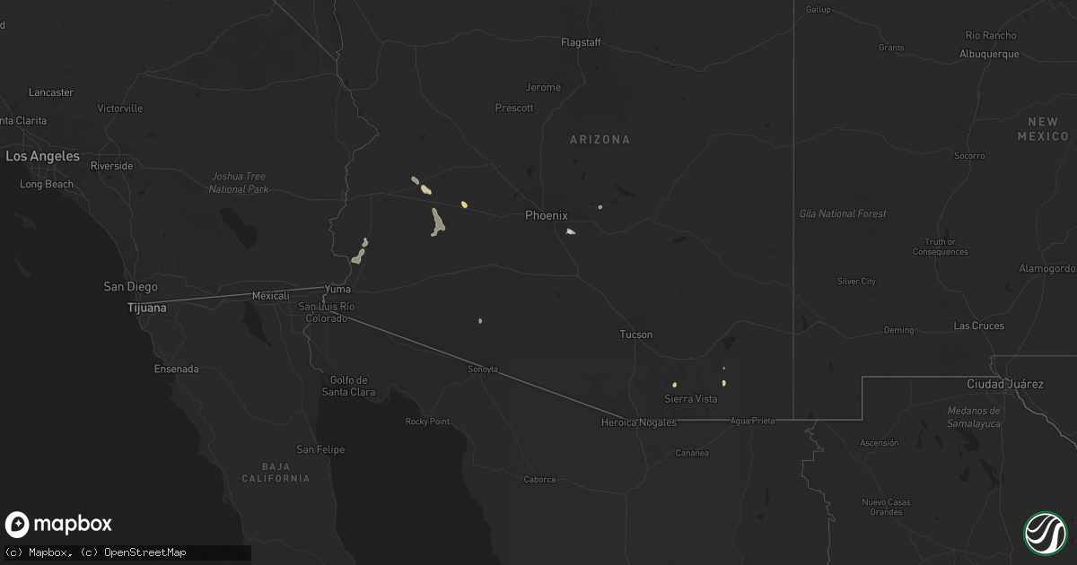
Hail Map in Arizona on September 23, 2022
Get this storm
September 23 map
$229
one time, instant access
Download today. No call, no setup
Keep the $229
Bought the map and want the full workflow? Apply the entire $229 to a subscription within 7 days. None of it is wasted.
Every map, not just this one
This buys you this map. Subscription and you get every map we run, in the markets you choose from a few cities to whole states to nationwide. Plus real-time alerts the moment a storm fires.
Contact data
Name, contact info, occupancy, even credit band for addresses in the footprint. You go from where it hit to who to call.
Become the source they trust
Unlimited branding weather history reports on demand. You already have the documented answer ready for the property owner, and you are the one who showed up with it.
Property data and RoofTrace estimates
Pull up any address you have got, its value and the exact code rules for that jurisdiction, straight from One Click Code. Then RoofTrace estimates the squares, pitch, and roof value, priced the way you price.
Storm reports in Arizona
Arizona
| Date | Description |
|---|---|
| 09/23/20225:42 PM CDT | Corrects previous tstm wnd gst report from 19 nnw ligurta. Yuma proving ground station measured a peak gust of 76 mph. |
| 09/23/20225:00 PM CDT | Ham radio personnel reported that us-95 was impassable at around mile marker 69 due to overflowing water. |
| 09/23/20223:10 PM CDT | Report from trained spotter described window broken from north side of the local post office and roof damage at lnwilliams engineering and mining manufacturing building |
| 09/23/20227:56 AM CDT | At 1256 PM MST, a severe thunderstorm was located near Superior, and is nearly stationary. HAZARD...60 mph wind gusts and nickel size hail. SOURCE...Radar indicated. IMPACT...Expect damage to roofs, siding, and trees. Locations impacted include... Superior, Top Of The World, Boyce Thompson Arboretum and Top-Of-The-World.This includes the following highways...US Highway 60 between mile markers 222 and 235.AZ Route 177 between mile markers 159 and 167. |
| 09/23/202212:45 AM CDT | At 545 PM MST, a severe thunderstorm was located over Tumbleweed Park, or near Gilbert, moving southeast at 10 mph. HAZARD...60 mph wind gusts. SOURCE...Radar indicated. IMPACT...Expect damage to roofs, siding, and trees. Locations impacted include... Mesa, Chandler, Gilbert, Sun Lakes, Queen Creek, Chandler Heights, Gilbert City Hall, Tumbleweed Park, Chandler City Hall, San Tan Village Mall, Seville, Freestone Park, Phoenix Mesa Gateway Airport, San Tan Mountain Park and Higley.This includes the following highways...US Highway 60 between mile markers 179 and 184.AZ Route 87 between mile markers 160 and 173.AZ Route 202 between mile markers 33 and 50. |
| 09/22/202211:41 PM CDT | At 440 PM MST, a severe thunderstorm was located near Camp Creek, or 13 miles northeast of Scottsdale, moving northwest at 5 mph. HAZARD...60 mph wind gusts and quarter size hail. SOURCE...Radar indicated. IMPACT...Hail damage to vehicles is expected. Expect wind damage to roofs, siding, and trees. Locations impacted include... Scottsdale, New River, Cave Creek, Carefree, Desert Mountain, Camp Creek, Rio Verde, Horseshoe Reservoir and Seven Springs. |
| 09/22/202211:38 PM CDT | At 438 PM MST, a severe thunderstorm was located 10 miles southeast of Ligurta, or 13 miles southeast of Fortuna Foothills, moving east at 5 mph. HAZARD...60 mph wind gusts. SOURCE...Radar indicated. IMPACT...Expect damage to roofs, siding, and trees. Locations impacted include... Wellton.This includes AZ Interstate 8 between mile markers 28 and 35. |
| 09/22/202211:24 PM CDT | At 424 PM MST, a severe thunderstorm was located over Ajo, and is nearly stationary. HAZARD...60 mph wind gusts and quarter size hail. SOURCE...Radar indicated. IMPACT...Hail damage to vehicles is expected. Expect wind damage to roofs, siding, and trees. Locations impacted include... Ajo and Why. |
| 09/22/202210:06 PM CDT | At 306 PM MST, a severe thunderstorm was located near Elgin, or 20 miles northwest of Sierra Vista, and is nearly stationary. HAZARD...60 mph wind gusts and quarter size hail. SOURCE...Radar indicated. IMPACT...Hail damage to vehicles is expected. Expect wind damage to roofs, siding, and trees. Locations impacted include... Whetstone, Sonoita, Elgin and Fort Huachuca. |
| 09/22/20229:32 PM CDT | At 232 PM MST, a severe thunderstorm was located 8 miles northwest of Tonopah, moving southeast at 10 mph. HAZARD...60 mph wind gusts and penny size hail. SOURCE...Radar indicated. IMPACT...Expect damage to roofs, siding, and trees. Locations impacted include... Tonopah, Palo Verde Nuclear Generation Station and Wintersburg. This includes AZ Interstate 10 between mile markers 75 and 104. |
| 09/22/20229:20 PM CDT | At 220 PM MST, a severe thunderstorm was located near Yuma Proving Ground, or 11 miles northeast of Martinez Lake, and is nearly stationary. HAZARD...60 mph wind gusts. SOURCE...Radar indicated. IMPACT...Expect damage to roofs, siding, and trees. Locations impacted include... Yuma Proving Ground.This includes AZ Route 95 between mile markers 48 and 76. |
| 09/22/20228:29 PM CDT | At 129 PM MST, a severe thunderstorm was located near Salome, or 37 miles south of Alamo Lake, and is nearly stationary. HAZARD...60 mph wind gusts and quarter size hail. SOURCE...Radar indicated. IMPACT...Hail damage to vehicles is expected. Expect wind damage to roofs, siding, and trees. Locations impacted include... Salome and Wenden. This includes the following highways...AZ Interstate 10 between mile markers 60 and 62.US Highway 60 between mile markers 50 and 52.AZ Route 72 near mile marker 49. |
| 09/22/20228:10 PM CDT | At 110 PM MST, a severe thunderstorm was located near Harcuvar, or 30 miles south of Alamo Lake, and is nearly stationary. HAZARD...60 mph wind gusts and quarter size hail. SOURCE...Radar indicated. IMPACT...Hail damage to vehicles is expected. Expect wind damage to roofs, siding, and trees. Locations impacted include... Wenden, Salome and Harcuvar. This includes US Highway 60 between mile markers 51 and 64. |
| 09/22/20227:47 PM CDT | 63 mph wind gust measured at chandler municipal airport awos. |


