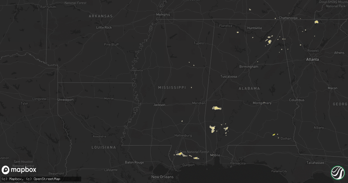
Hail Map in Mississippi on September 23, 2017
Get this storm
September 23 map
$229
one time, instant access
Download today. No call, no setup
Keep the $229
Bought the map and want the full workflow? Apply the entire $229 to a subscription within 7 days. None of it is wasted.
Every map, not just this one
This buys you this map. Subscription and you get every map we run, in the markets you choose from a few cities to whole states to nationwide. Plus real-time alerts the moment a storm fires.
Contact data
Name, contact info, occupancy, even credit band for addresses in the footprint. You go from where it hit to who to call.
Become the source they trust
Unlimited branding weather history reports on demand. You already have the documented answer ready for the property owner, and you are the one who showed up with it.
Property data and RoofTrace estimates
Pull up any address you have got, its value and the exact code rules for that jurisdiction, straight from One Click Code. Then RoofTrace estimates the squares, pitch, and roof value, priced the way you price.
Storm reports in Mississippi
Mississippi
| Date | Description |
|---|---|
| 09/23/20176:45 PM CDT | A few trees were blown down along salem church road north of collins. |
| 09/23/20176:20 PM CDT | A power pole was blown down along little black creek road southwest of purvis. Several trees were also blown down around the area between purvis and baxterville. |
| 09/23/20176:14 PM CDT | Damage in seminary from microburst winds included a peeled back roof on the post office... Minor shingle damage on a home... A 2 to 3 foot diameter pine tree uprooted n |
| 09/23/20175:35 PM CDT | A tree 6 inch in diameter was downed near cr 128 and pea sized hail occurred. |
| 09/23/20174:45 PM CDT | A few trees were blown down along gilbert hill road... Approximately one half mile west of ms highway 15. Report relayed by wcbi. |
| 09/22/20178:40 PM CDT | Damage in seminary from microburst winds included a peeled back roof on the post office... Minor shingle damage on a home... A 2 to 3 foot diameter pine tree uprooted n |
| 09/22/20177:02 PM CDT | A few trees were blown down along dan easterling road west of collins. |
All States Impacted by Hail Map on September 23, 2017
Cities Impacted by Hail Map on September 23, 2017
- Pyote, TX
- Farnam, NE
- Salt Flat, TX
- Fort Hancock, TX
- Delmont, SD
- Dell City, TX
- Lamar, CO
- Ramona, SD
- Wood, SD
- Mission, SD
- Millry, AL
- Frankville, AL
- Chatom, AL
- Saint Stephens, AL
- New Ulm, MN
- Sleepy Eye, MN
- Gibbon, MN
- Fairfax, MN
- Hinckley, MN
- Brook Park, MN
- Mora, MN
- Oconto, NE
- Sumner, NE
- Sierra Blanca, TX
- Armour, SD
- Montgomery, AL
- Vancleave, MS
- Petersburg, TN
- Cornersville, TN
- Piedmont, AL
- Centre, AL
- Perkinston, MS
- Poplarville, MS
- Carriere, MS
- Enterprise, AL
- Mason City, NE
- Parkston, SD
- Finlayson, MN
- Sweet Water, AL
- Pennington, AL
- Butler, AL
- Clarkfield, MN
- Hanley Falls, MN
- Wagner, SD
- Crossville, AL
- Albertville, AL
- Cartersville, GA
- Carlsbad, NM
- Wentworth, SD
- Rutland, SD
- Oldham, SD
- Nunda, SD
- Madison, SD
- Canova, SD
- Winfred, SD
- Volga, SD
- Springfield, CO
- Mobile, AL
- Haxtun, CO
- Norton, KS
- Howard, SD
- Mineral Bluff, GA
- Morganton, GA
- Blue Ridge, GA
- Bartley, NE
- Arlington, SD
- Gothenburg, NE
- Willow Island, NE
- Cozad, NE
- Dimock, SD
- Eustis, NE
- Gainestown, AL
- Salem, SD
- Lynch, NE
- Bristow, NE
- Starkville, MS
- Odenville, AL
- Cleveland, TN
- Flandreau, SD
- Colman, SD
- Saucier, MS
- Barstow, TX
- Spencer, SD
- Ward, AL
- Grove Hill, AL
- Whatley, AL
- Jackson, AL
- Alexandria, SD
- Mitchell, SD
- Ethan, SD
- Fort Rucker, AL
- Yuma, CO
- Elsmere, NE
- Johnstown, NE
- Spencer, NE
- Maben, MS
- Tibbie, AL
- Wagarville, AL
- Boaz, AL
- Groveoak, AL
- Jachin, AL
- Moulton, AL
- Hillsboro, AL
- South Pittsburg, TN
- Cold Spring, MN
- Eight Mile, AL
- Sparta, TN
- Mcminnville, TN
- Minneota, MN
- Fyffe, AL
- Rainsville, AL
- Geraldine, AL
- Dawson, AL
- Richmond, MN
- Arco, MN
- Valentine, NE
- Lake Andes, SD
- Van Horn, TX
- Jasper, GA
- Hixson, TN
- Cedartown, GA
- Cave Spring, GA
- Pecos, TX
- Wink, TX
- Somerville, AL
- Philadelphia, MS
- Porter, MN
- Okreek, SD
- Uriah, AL
- Fulton, SD
- Broken Bow, NE
- Eddyville, NE
- Dunnellon, FL
- Ogilvie, MN
- Fort Payne, AL
- Gaylesville, AL
- Daleville, AL
- Newton, AL
- Eden Valley, MN
- Taunton, MN
- Chatsworth, GA
- Ellijay, GA
- Sinai, SD
- Lyerly, GA
- Soso, MS
- Taylorsville, MS
- Shorter, AL
- Monahans, TX
- Sedgwick, CO
- Oakley, KS
- Monument, KS


