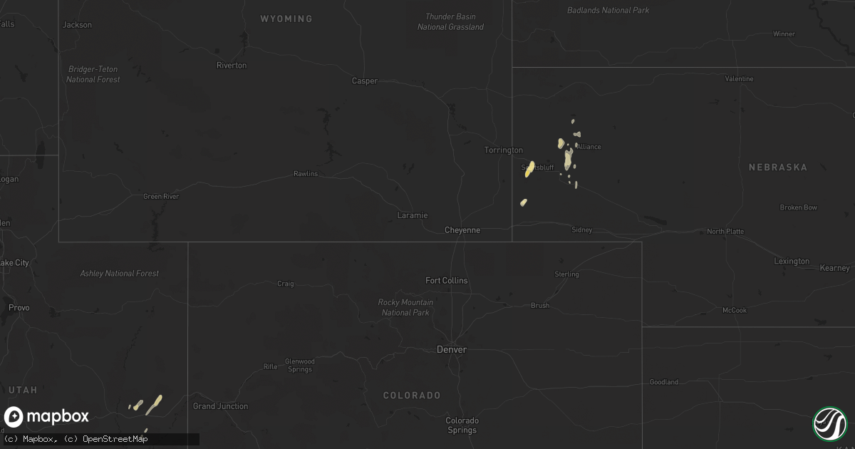
Hail Map in Colorado on September 22, 2013
Get this storm
September 22 map
$229
one time, instant access
Download today. No call, no setup
Keep the $229
Bought the map and want the full workflow? Apply the entire $229 to a subscription within 7 days. None of it is wasted.
Every map, not just this one
This buys you this map. Subscription and you get every map we run, in the markets you choose from a few cities to whole states to nationwide. Plus real-time alerts the moment a storm fires.
Contact data
Name, contact info, occupancy, even credit band for addresses in the footprint. You go from where it hit to who to call.
Become the source they trust
Unlimited branding weather history reports on demand. You already have the documented answer ready for the property owner, and you are the one who showed up with it.
Property data and RoofTrace estimates
Pull up any address you have got, its value and the exact code rules for that jurisdiction, straight from One Click Code. Then RoofTrace estimates the squares, pitch, and roof value, priced the way you price.
Storm reports in Colorado
Colorado
| Date | Description |
|---|---|
| 09/22/20136:53 PM CDT | Low level wind shear sensor at dia |
| 09/22/20136:24 PM CDT | Measured at the asos at centennial airport |
| 09/22/20134:32 PM CDT | A local report indicates 1.00 inch wind near 3 SSE CRESTONE |
| 09/22/20134:15 PM CDT | 2 windows blown out. Roof damage and 12 trees blown down. Relayed from crestone coop. Time estimated. |
| 09/22/20134:10 PM CDT | A local report indicates 1.25 inch wind near 6 E BAYFIELD |
| 09/22/20134:03 PM CDT | San luis valley |
| 09/22/20133:53 PM CDT | Very heavy rain with up to quarter size hail |
| 09/22/20133:50 PM CDT | Ping pong ball size hail. Time estimated based on radar. Standing water of 4 inches in backyard and 6 inches in the front yard. |
| 09/22/20133:38 PM CDT | Peak thunderstorm wind gust at durango la plata county airport |
| 09/22/20133:30 PM CDT | Estimated up to 2 inch diameter hail fell |
| 09/22/20133:23 PM CDT | Skywarn spotter reported half dollar sized hail in durango...1.25 inch diameter |
| 09/22/20133:14 PM CDT | 1.4 inch diameter hail around 214 pm mdt. |
| 09/22/20132:51 PM CDT | Ping pong size hail with estimated 60 to 70 mph winds. Stripping leaves and branches off trees. |
| 09/22/20132:51 PM CDT | Ping pong ball size hail with estimated 60 to 70 mph winds. Stripping leaves and branches off trees. |
| 09/22/20132:30 PM CDT | Storm spotter reported finding 1.4 inch diatmeter hail on the ground at intersection of highwy 141 and county road e. |
| 09/22/20132:30 PM CDT | Estimated up to 2 inch diameter hail fell |
| 09/22/20132:20 PM CDT | Quarter size hail on highway 90 at mm23 east of bedrock and paradox valley. |
| 09/21/20138:53 PM CDT | Measured at the akron airport asos |
All States Impacted by Hail Map on September 22, 2013
Cities Impacted by Hail Map on September 22, 2013
- Bedrock, CO
- Mitchell, NE
- Gering, NE
- Scottsbluff, NE
- Angora, NE
- Bayard, NE
- Hesperus, CO
- Durango, CO
- Bayfield, CO
- Farmington, NM
- Dove Creek, CO
- Monticello, UT
- Philip, SD
- Towaoc, CO
- Blanding, UT
- Thompson, UT
- Ignacio, CO
- Dulce, NM
- Bloomfield, NM
- Cuba, NM
- Alliance, NE
- Crownpoint, NM
- Jemez Springs, NM
- Thoreau, NM
- Canon City, CO
- Harrisburg, NE
- Gallina, NM
- Hemingford, NE
- Bridgeport, NE
- Naturita, CO
- Nucla, CO
- Egnar, CO
- Mandan, ND
- Crestone, CO
- Los Lunas, NM
- Creede, CO
- Pagosa Springs, CO


