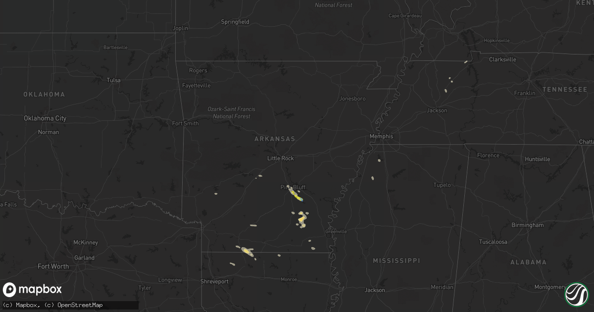
Hail Map in Arkansas on September 21, 2021
Get this storm
September 21 map
$229
one time, instant access
Download today. No call, no setup
Keep the $229
Bought the map and want the full workflow? Apply the entire $229 to a subscription within 7 days. None of it is wasted.
Every map, not just this one
This buys you this map. Subscription and you get every map we run, in the markets you choose from a few cities to whole states to nationwide. Plus real-time alerts the moment a storm fires.
Contact data
Name, contact info, occupancy, even credit band for addresses in the footprint. You go from where it hit to who to call.
Become the source they trust
Unlimited branding weather history reports on demand. You already have the documented answer ready for the property owner, and you are the one who showed up with it.
Property data and RoofTrace estimates
Pull up any address you have got, its value and the exact code rules for that jurisdiction, straight from One Click Code. Then RoofTrace estimates the squares, pitch, and roof value, priced the way you price.
Storm reports in Arkansas
Arkansas
| Date | Description |
|---|---|
| 09/21/20211:19 PM CDT | Tree limbs were blown down in star city. |
| 09/21/202112:41 PM CDT | Trees and power lines were blown down. |
| 09/21/202112:36 PM CDT | Homes were damaged. |
| 09/21/20217:33 AM CDT | At 1233 PM CDT, a severe thunderstorm was located near Pine Bluff, moving east at 25 mph. HAZARD...60 mph wind gusts and quarter size hail. SOURCE...Radar indicated. IMPACT...Hail damage to vehicles is expected. Expect wind damage to roofs, siding, and trees. Locations impacted include... Pine Bluff... Star City... White Hall... Grady... Nebo... Cottondale... Woodville... Whitefield... Linwood... Richardson... Madding... Cane Creek State Park... Sulphur Springs... Tarry... Tamo... Pinebergen... Faith... Moscow... Crigler... Ladd...This includes Interstate 530 between mile markers 35 and 46. |
| 09/21/20217:21 AM CDT | At 1221 PM CDT, a severe thunderstorm was located 7 miles southwest of Redfield, or 9 miles east of Sheridan, moving east at 25 mph. HAZARD...60 mph wind gusts and quarter size hail. SOURCE...Radar indicated. IMPACT...Hail damage to vehicles is expected. Expect wind damage to roofs, siding, and trees. Locations impacted include... Pine Bluff... White Hall... Redfield... Altheimer... Cottondale... Pine Bluff Arsenal... Madding... Warbritton... Hensley Island... Wabbaseka... Sherrill... Tucker... Pastoria... Wright... Lock and Dam 5 Park... Kearney... Glenlake... Center Grove... Clear Lake... Hardin...This includes Interstate 530 between mile markers 21 and 38, andbetween mile markers 45 and 46. |
| 09/20/20219:11 PM CDT | At 211 AM CDT, a severe thunderstorm was located over Lincoln, moving east at 20 mph. HAZARD...60 mph wind gusts and quarter size hail. SOURCE...Radar indicated. IMPACT...Hail damage to vehicles is expected. Expect wind damage to roofs, siding, and trees. Locations in or near the path include... Prairie Grove... West Fork... Lincoln... Greenland... Strickler... Cincinnati... Blackburn... Prairie Grove Battlefield State... Walnut Grove... Clyde... Rhea... Canehill... Hogeye... Summers... Morrow... Viney Grove...This includes Interstate 49 between mile markers 49 and 56. |
| 09/20/20218:42 PM CDT | At 141 PM CDT, a severe thunderstorm was located near Camden, moving east at 30 mph. HAZARD...60 mph wind gusts and quarter size hail. SOURCE...Radar indicated. IMPACT...Hail damage to vehicles is expected. Expect wind damage to roofs, siding, and trees. Locations impacted include... Camden... Hampton... Louann... Cullendale... Hampton Municipal Airport... Delhi... Kirkland... Millers Bluff... Frenchport... Elliot... Cross Roads in Ouachita County... Fairview in Ouachita County... Locust Bayou... Standard Umpstead... Woodberry... Buena Vista... |
| 09/20/20218:05 PM CDT | At 105 PM CDT, a severe thunderstorm was located over Nebo, or near Star City, moving southeast at 35 mph. HAZARD...60 mph wind gusts and quarter size hail. SOURCE...Radar indicated. IMPACT...Hail damage to vehicles is expected. Expect wind damage to roofs, siding, and trees. Locations impacted include... Star City... Gould... Grady... Nebo... Feenyville... Whitefield... Douglas... Cane Creek State Park... Mills... Garrett Bridge... Tarry... Gourd... Calhoun... Florence... Tyro... Rose Hill... Crigler... Fresno... Garnett... Varner... |
All States Impacted by Hail Map on September 21, 2021
Cities Impacted by Hail Map on September 21, 2021
- Pine Bluff, AR
- Haynesville, LA
- Monticello, AR
- Brackettville, TX
- Summerfield, LA
- Bernice, LA
- Coldwater, MS
- Emerson, AR
- Junction City, AR
- Star City, AR
- Buchanan, TN
- Cotton Valley, LA
- Minden, LA
- McKenzie, TN
- Rusk, TX
- Hamburg, AR
- Montrose, AR
- Wilmar, AR
- Marion, LA
- Malvern, AR
- Sledge, MS
- Camden, AR
- Atwood, TN
- Trezevant, TN
- Huntingdon, TN
- Wilmot, AR
- Parkdale, AR
- Magnolia, AR
- Rison, AR
- Warren, AR
- Murfreesboro, AR
- White Hall, AR
- Dryden, TX
- Del Rio, TX


