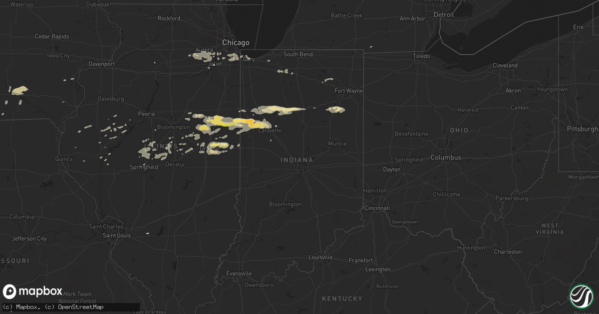
Hail Map in Indiana on September 18, 2015
Get this storm
September 18 map
$229
one time, instant access
Download today. No call, no setup
Keep the $229
Bought the map and want the full workflow? Apply the entire $229 to a subscription within 7 days. None of it is wasted.
Every map, not just this one
This buys you this map. Subscription and you get every map we run, in the markets you choose from a few cities to whole states to nationwide. Plus real-time alerts the moment a storm fires.
Contact data
Name, contact info, occupancy, even credit band for addresses in the footprint. You go from where it hit to who to call.
Become the source they trust
Unlimited branding weather history reports on demand. You already have the documented answer ready for the property owner, and you are the one who showed up with it.
Property data and RoofTrace estimates
Pull up any address you have got, its value and the exact code rules for that jurisdiction, straight from One Click Code. Then RoofTrace estimates the squares, pitch, and roof value, priced the way you price.
Storm reports in Indiana
Indiana
| Date | Description |
|---|---|
| 09/18/20151:55 AM CDT | Large tree down near pine lake. |
| 09/17/201510:15 PM CDT | Large tree down on powerline |
| 09/17/201510:05 PM CDT | Widespread tree damage. All blown in the same direction. Some metal roofing peeled off a barn. |
| 09/17/201510:05 PM CDT | Tree down. No information on size/health. |
| 09/17/20159:58 PM CDT | Reports of tree limbs down within the city of logansport. |
| 09/17/20159:50 PM CDT | Numerous reports from logansport eastward of downed trees... Tree limbs. There are also reports of ponding water... Up to the curb in a few areas. |
| 09/17/20159:43 PM CDT | Located at us 52 and piermont drive. |
| 09/17/20159:42 PM CDT | Sustained winds measured at 59 mph at sr 25 north and cr 900 n. |
| 09/17/20159:30 PM CDT | Roof blown off hog barn |
| 09/17/20159:25 PM CDT | Observation at white county airport |
| 09/17/20159:25 PM CDT | Numerous trees and power lines down. |
| 09/17/20159:25 PM CDT | Numerous trees and powerlines down along n 400 e to shafer dr |
| 09/17/20159:00 PM CDT | Large hail reported across southern parts of benton county. |
All States Impacted by Hail Map on September 18, 2015
Cities Impacted by Hail Map on September 18, 2015
- Middletown, IL
- Greenview, IL
- Clatonia, NE
- Doniphan, NE
- Hastings, NE
- Juniata, NE
- Aurora, NE
- Harvard, NE
- Giltner, NE
- Trumbull, NE
- Mead, NE
- Ottumwa, IA
- Hedrick, IA
- Clarendon, TX
- Mclean, TX
- Alvo, NE
- Ashland, NE
- Elmwood, NE
- Eagle, NE
- Murdock, NE
- Greenwood, NE
- Lincoln, NE
- Louisville, NE
- Waverly, NE
- Wellington, TX
- Whitewater, KS
- Potwin, KS
- Burns, KS
- Galesburg, KS
- Parsons, KS
- Childress, TX
- Dodson, TX
- Hedley, TX
- Quail, TX
- Weston, NE
- Hermitage, MO
- Eudora, KS
- Lawrence, KS
- Baldwin City, KS
- Fairfax, OK
- Pawnee, OK
- Huntington, IN
- Talmage, NE
- Farragut, IA
- Sterling, NE
- Nebraska City, NE
- Lorton, NE
- Cook, NE
- Burr, NE
- Syracuse, NE
- Hamburg, IA
- Riverton, IA
- Sidney, IA
- Shenandoah, IA
- Dunbar, NE
- Pleasanton, NE
- Riverdale, NE
- Amherst, NE
- Dill City, OK
- Foss, OK
- Sentinel, OK
- Canute, OK
- Cordell, OK
- Markle, IN
- Astoria, IL
- Ipava, IL
- Seward, NE
- Milford, NE
- Pleasant Dale, NE
- Adair, IL
- Marietta, IL
- Macomb, IL
- Table Grove, IL
- Wakita, OK
- Randolph, IA
- Yates Center, KS
- Piqua, KS
- Shelton, NE
- Gibbon, NE
- Davis City, IA
- Lamoni, IA
- Decatur, IA
- Leon, IA
- Hartsburg, IL
- Lincoln, IL
- New Holland, IL
- Memphis, TX
- Romney, IN
- Larwill, IN
- Pierceton, IN
- Columbia City, IN
- Albion, IN
- Essex, IA
- Clarinda, IA
- Dacoma, OK
- Carmen, OK
- Cherokee, OK
- Lucas, IA
- Osceola, IA
- Woodburn, IA
- Phillips, NE
- Potomac, IL
- Penfield, IL
- Armstrong, IL
- Argenta, IL
- Eureka, KS
- Bradshaw, NE
- Hampton, NE
- Ambia, IN
- Hoopeston, IL
- Cissna Park, IL
- Melvin, IL
- Rankin, IL
- Roberts, IL
- Wellington, IL
- Oxford, IN
- Onarga, IL
- Otterbein, IN
- Thawville, IL
- Buckley, IL
- Templeton, IN
- Boswell, IN
- Loda, IL
- Milford, IL
- Fowler, IN
- Pine Village, IN
- West Lafayette, IN
- Bellflower, IL
- Caldwell, KS
- Hopedale, IL
- Medicine Lodge, KS
- Jet, OK
- Moravia, IA
- Albia, IA
- Oswego, IL
- Joliet, IL
- Plano, IL
- Yorkville, IL
- Montgomery, IL
- Aurora, IL
- Bolingbrook, IL
- Plainfield, IL
- Naperville, IL
- Romeoville, IL
- Bristol, IL
- Minooka, IL
- Firth, NE
- Mobeetie, TX
- Wheeler, TX
- Saint Paul, KS
- Wynona, OK
- Reynolds, IN
- Idaville, IN
- Burnettsville, IN
- Monticello, IN
- Logansport, IN
- Maroa, IL
- Corning, IA
- Riverdale, IL
- Blue Island, IL
- Chicago, IL
- Independence, KS
- Thayer, KS
- Dennis, KS
- Cherryvale, KS
- Davey, NE
- Malcolm, NE
- Raymond, NE
- Ravenna, NE
- Canton, IL
- Wolcott, IN
- Royal Center, IN
- Chalmers, IN
- Monon, IN
- Delphi, IN
- Walton, IN
- Pickrell, NE
- Malvern, IA
- Warren, IN
- Bluffton, IN
- Cincinnati, IA
- Ludlow, IL
- Brookston, IN
- Chatsworth, IL
- Williamsport, IN
- Gibson City, IL
- Dewey, IL
- Battle Ground, IN
- Saybrook, IL
- Lafayette, IN
- Sibley, IL
- Rossville, IL
- Elliott, IL
- Paxton, IL
- Stockland, IL
- Rantoul, IL
- Fisher, IL
- Foosland, IL
- Paola, KS
- Edgerton, KS
- Wellsville, KS
- Le Roy, IL
- Jennings, OK
- Maramec, OK
- Cleveland, OK
- Perkins, OK
- Elk City, OK
- Hamlet, IN
- Grovertown, IN
- Walkerton, IN
- Harper, KS
- Knox, IN
- Jamesport, MO
- Chillicothe, MO
- Trenton, MO
- Drumright, OK
- Cushing, OK
- Cassoday, KS
- El Dorado, KS
- Fort Stockton, TX
- Benedict, NE
- Vermont, IL
- Isabella, OK
- Urbana, IL
- Saint Joseph, IL
- Newtown, MO
- Pollock, MO
- Harris, MO
- Girard, KS
- Benton, KS
- Valley Center, KS
- Wood River, NE
- Heartwell, NE
- Kenesaw, NE
- Floydada, TX
- Minden, NE
- Adams, NE
- Cortland, NE
- Aviston, IL
- Breese, IL
- Littleton, IL
- Agency, IA
- Greeley, KS
- Garnett, KS
- Piedmont, KS
- Fall River, KS
- Severy, KS
- Fithian, IL
- Ogden, IL
- Danville, IL
- Hallam, NE
- Martell, NE
- Wilber, NE
- Stillwater, OK
- Hutchinson, KS
- Valparaiso, NE
- Plattsmouth, NE
- Pacific Junction, IA
- White Cloud, KS
- Nash, OK
- Medford, OK
- Gresham, NE
- Weldon, IA
- Derby, IA
- Humeston, IA
- Farmer City, IL
- Strawn, IL
- Fairbury, IL
- Forrest, IL
- Anadarko, OK
- Mooreland, OK
- Unionville, MO
- Unadilla, NE
- Chenoa, IL
- Florence, KS
- Saint David, IL
- Aline, OK
- Alva, OK
- Waynoka, OK
- Walker, MO
- El Dorado Springs, MO
- Cropsey, IL
- Homer Glen, IL
- Orland Park, IL
- Midlothian, IL
- Country Club Hills, IL
- Palos Heights, IL
- South Holland, IL
- Alsip, IL
- Posen, IL
- Tinley Park, IL
- Markham, IL
- Dolton, IL
- Calumet City, IL
- Harvey, IL
- Crestwood, IL
- Oak Forest, IL
- Hazel Crest, IL
- Homewood, IL
- Robbins, IL
- Verden, OK
- South Bend, NE
- Weeping Water, NE
- Manley, NE
- Springfield, NE
- Gretna, NE
- Richmond, KS
- Ames, OK
- Fontana, KS
- Osawatomie, KS
- Lane, KS
- Parker, KS
- Kellyville, OK
- Woodridge, IL
- Lemont, IL
- Madison, KS
- Gifford, IL
- East Chicago, IN
- Hammond, IN
- De Land, IL
- Cisco, IL
- Monticello, IL
- York, NE
- Utica, NE
- Waco, NE
- Homer, IL
- Sidney, IL
- Philo, IL
- Gallatin, MO
- Beaver Crossing, NE
- Burrton, KS
- Bluff City, KS
- Henderson, NE
- Gower, MO
- Stewartsville, MO
- Stanton, TX
- Marquette, NE
- Grand Island, NE
- Clayton, IL
- New London, IA
- Sutton, NE
- Avon, IL
- Beardstown, IL
- Arenzville, IL
- Lost Springs, KS
- Hartford, KS
- Waynesville, IL
- Clinton, IL
- Kenney, IL
- Beason, IL
- Toronto, KS
- Virgil, KS
- Lexington, NE
- Powersville, MO
- Lucerne, MO
- Smithfield, IL
- Moundville, MO
- Osage, OK
- Lewistown, IL
- Liverpool, IL
- Mystic, IA
- Lockney, TX
- Manchester, OK
- Anthony, KS
- Springfield, IL
- Cameron, MO
- Kidder, MO
- Osborn, MO
- McLean, IL
- Athens, IL
- Elkhart, IL
- Petersburg, IL
- Williamsville, IL
- Sherman, IL
- Waverly, KS
- Melvern, KS
- Cleo Springs, OK
- Gary, IN
- Oakwood, IL
- Catlin, IL
- Stanton, IA
- Arlington, KS
- Royal, IL
- Argonia, KS
- Fairmount, IL
- Ottawa, KS
- Reading, MI
- Hillsdale, MI
- Mason City, IL
- San Jose, IL
- Hickman, NE
- Braman, OK
- Mount Sterling, IL
- Lahoma, OK
- Meno, OK
- Ripley, OK
- Dewitt, IL
- Wapella, IL
- Browning, MO
- Purdin, MO
- Linneus, MO
- Glencoe, OK
- Blakesburg, IA
- Unionville, IA
- Olpe, KS
- Seymour, IA
- Custer City, OK
- Sedan, KS
- Blandinsville, IL
- Colchester, IL
- Hamilton, KS
- Glenwood, IA
- Loraine, IL
- Mendon, IL
- Belton, MO
- Alda, NE
- Channahon, IL
- Cuba, IL
- Enid, OK
- Hartville, MO
- Goodland, IN
- Peru, IN
- Remington, IN
- Camden, IN
- New Waverly, IN
- Garland, NE
- Weldon, IL
- Hamilton, MO
- Batavia, IA
- Packwood, IA
- Cedar Point, KS
- Ceresco, NE
- Hammon, OK
- Goehner, NE
- McCool Junction, NE
- Bloomfield, IA
- London Mills, IL
- Matador, TX
- Durham, KS
- Nodaway, IA
- Carbon, IA
- Villisca, IA
- Champaign, IL
- Seymour, IL
- Eddyville, IA
- Mansfield, IL
- Mahomet, IL
- Helena, OK
- Mountain Grove, MO
- Savoy, IL
- Tolono, IL
- Columbus City, IA
- Columbus Junction, IA
- Howard, KS
- Humphreys, MO
- Milan, MO
- Galt, MO
- Lexington, IL
- Colfax, IL
- Turon, KS
- Staplehurst, NE
- Plattsburg, MO
- Wheatland, MO
- Chula, MO
- La Porte, IN
- Westville, IN
- Imogene, IA
- Raymore, MO
- Walton, NE
- Roca, NE
- Bennet, NE
- Rushville, IL
- Sandwich, IL
- Somonauk, IL
- Arrowsmith, IL
- Haven, KS
- Gridley, KS
- Lockport, IL
- Carthage, IL
- Emden, IL
- Lincolnville, KS
- Neodesha, KS
- Wabash, IN
- Lebo, KS
- Justice, IL
- Wichita, KS
- Hope, KS
- Mount Pulaski, IL
- Latham, IL
- Walnut, KS
- Moulton, IA
- Hominy, OK
- Wapello, IA
- Grandview, IA
- Prescott, IA
- Creston, IA
- Holstein, NE
- Heyworth, IL
- Rosalia, KS
- Burlington, KS
- Sheldon, IL
- Andrews, IN
- Liberty Center, IN
- Yale, OK
- Chestnut, IL
- Meadville, MO
- Plymouth, IN
- Douglas, NE
- Mound Valley, KS
- Ohio, IL
- Nardin, OK
- Blackwell, OK
- Guthrie, OK
- Kentland, IN
- Earl Park, IN
- Chester, OK
- Ringwood, OK
- Chapin, IL
- Meredosia, IL
- Stromsburg, NE
- Maysville, MO
- Rockville, NE
- Boelus, NE


