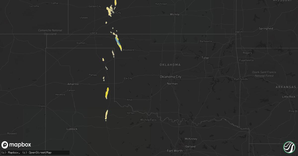
Hail Map in Oklahoma on September 17, 2021
Get this storm
September 17 map
$229
one time, instant access
Download today. No call, no setup
Keep the $229
Bought the map and want the full workflow? Apply the entire $229 to a subscription within 7 days. None of it is wasted.
Every map, not just this one
This buys you this map. Subscription and you get every map we run, in the markets you choose from a few cities to whole states to nationwide. Plus real-time alerts the moment a storm fires.
Contact data
Name, contact info, occupancy, even credit band for addresses in the footprint. You go from where it hit to who to call.
Become the source they trust
Unlimited branding weather history reports on demand. You already have the documented answer ready for the property owner, and you are the one who showed up with it.
Property data and RoofTrace estimates
Pull up any address you have got, its value and the exact code rules for that jurisdiction, straight from One Click Code. Then RoofTrace estimates the squares, pitch, and roof value, priced the way you price.
Storm reports in Oklahoma
Oklahoma
| Date | Description |
|---|---|
| 09/17/20213:04 AM CDT | At 803 PM CDT, a severe thunderstorm was located 4 miles southeast of May, moving southeast at 35 mph. THIS IS A DESTRUCTIVE STORM FOR NORTHEAST ELLIS COUNTY. HAZARD...80 mph wind gusts and quarter size hail. SOURCE...Radar indicated. IMPACT...Flying debris will be dangerous to those caught without shelter. Mobile homes will be heavily damaged. Expect considerable damage to roofs, windows, and vehicles. Extensive tree damage and power outages are likely. Locations impacted include... Woodward, Fargo, Fort Supply, May and Tangier. |
| 09/17/20212:48 AM CDT | At 748 PM CDT, a severe thunderstorm was located near May, moving southeast at 15 mph. HAZARD...70 mph wind gusts and quarter size hail. SOURCE...Radar indicated. IMPACT...Hail damage to vehicles is expected. Expect considerable tree damage. Wind damage is also likely to mobile homes, roofs, and outbuildings. Locations impacted include... Laverne and May. |
| 09/17/20212:28 AM CDT | At 727 PM CDT, a severe thunderstorm was located near Laverne, moving southeast at 15 mph. HAZARD...70 mph wind gusts and quarter size hail. SOURCE...Radar indicated. IMPACT...Hail damage to vehicles is expected. Expect considerable tree damage. Wind damage is also likely to mobile homes, roofs, and outbuildings. Locations impacted include... Laverne. |
| 09/17/20211:53 AM CDT | At 653 PM CDT, a severe thunderstorm was located 4 miles northeast of Rosston, moving southeast at 15 mph. HAZARD...60 mph wind gusts and penny size hail. SOURCE...Radar indicated. IMPACT...Expect damage to roofs, siding, and trees. Locations impacted include... Laverne, Buffalo and Rosston. |
| 09/16/20217:40 PM CDT | A local report indicates 72 MPH wind near 1 N LAVERNE |
| 09/16/20217:00 PM CDT | A local report indicates 1.00 inch wind near 3 N ROSSTON |
| 09/16/20217:00 PM CDT | A local report indicates 80 MPH wind near 4 N ROSSTON |
| 09/16/20217:00 PM CDT | Back window blown out of vehicle blown out and multiple power lines downed. |
| 09/16/20217:00 PM CDT | A local report indicates 86 MPH wind near 3 N ROSSTON |
Cities Impacted by Hail Map on September 17, 2021
- Little River, KS
- Lyons, KS
- Laverne, OK
- May, OK
- Fargo, OK
- Ellis, KS
- Plainville, KS
- Englewood, KS
- Meade, KS
- Holton, KS
- Sterling, KS
- Wellington, TX
- Cedar, KS
- Gaylord, KS
- Glade, KS
- Kirwin, KS
- Rosston, OK
- Jetmore, KS
- Novinger, MO
- Gate, OK
- Quail, TX
- Clarksdale, MO
- Dodge City, KS
- Cimarron, KS
- Ensign, KS
- Shamrock, TX
- Childress, TX
- Hays, KS
- Hill City, KS
- Victoria, KS
- Palco, KS
- Penokee, KS
- Phillipsburg, KS
- Bloomington, NE
- Franklin, NE
- Follett, TX
- Mobeetie, TX
- Morland, KS
- Everest, KS
- Effingham, KS
- Muscotah, KS
- Green Castle, MO
- Paducah, TX
- Canadian, TX
- Alma, NE
- Wright, KS
- Dearborn, MO
- Osborn, MO
- Lancaster, KS
- Atchison, KS
- Mcpherson, KS
- Agency, MO
- Gower, MO
- Higgins, TX
- Stewartsville, MO
- Ashland, KS
- Worthington, MO
- Unionville, MO
- Livonia, MO
- Easton, MO
- Milan, MO
- Winigan, MO
- New Boston, MO
- Republican City, NE


