Hail Map in Colorado on September 17, 2011
Get this storm
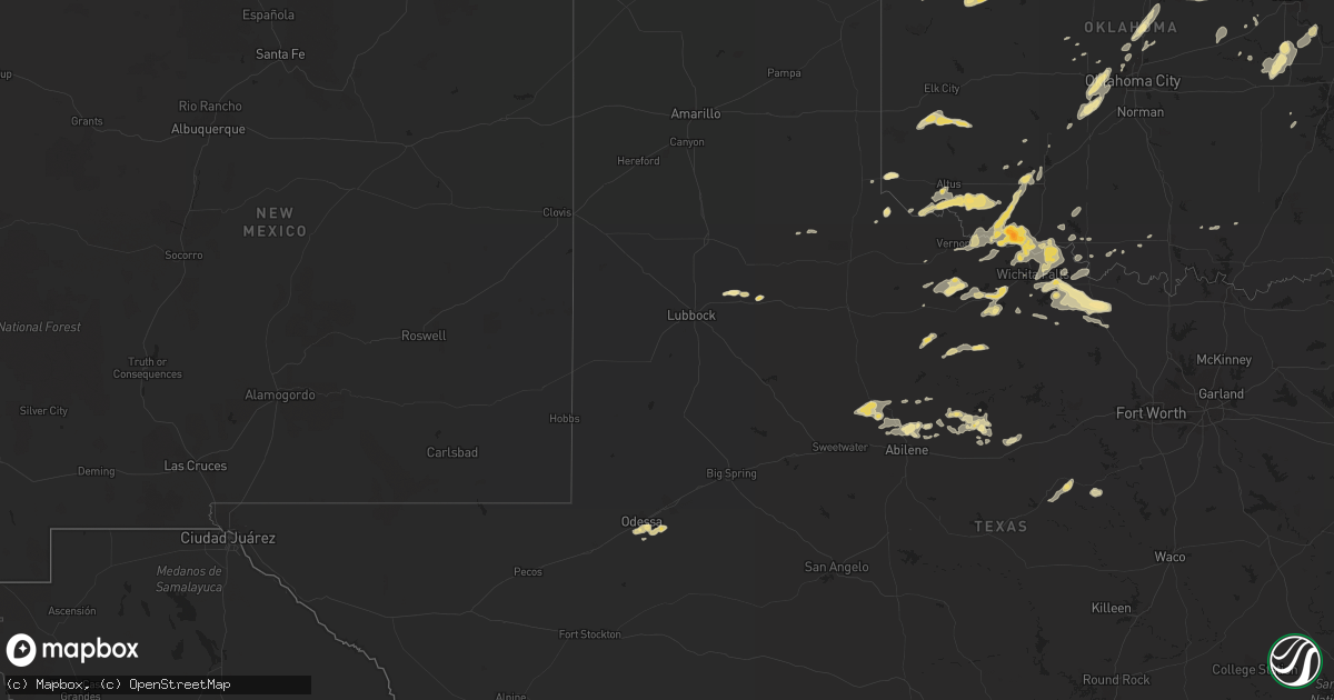
September 17 map
$229
one time, instant access
Download today. No call, no setup
Keep the $229
Bought the map and want the full workflow? Apply the entire $229 to a subscription within 7 days. None of it is wasted.
Every map, not just this one
This buys you this map. Subscription and you get every map we run, in the markets you choose from a few cities to whole states to nationwide. Plus real-time alerts the moment a storm fires.
Contact data
Name, contact info, occupancy, even credit band for addresses in the footprint. You go from where it hit to who to call.
Become the source they trust
Unlimited branding weather history reports on demand. You already have the documented answer ready for the property owner, and you are the one who showed up with it.
Property data and RoofTrace estimates
Pull up any address you have got, its value and the exact code rules for that jurisdiction, straight from One Click Code. Then RoofTrace estimates the squares, pitch, and roof value, priced the way you price.
Storm reports in Colorado
Colorado
| Date | Description |
|---|---|
| 09/17/20116:27 PM CDT | Report relayed by law enforcement of 2 reports of golf ball sized hail. |
| 09/17/20115:57 PM CDT | A local report indicates 1.75 inch wind near 10 SSW KIRK |
| 09/17/20115:45 PM CDT | A local report indicates 1.00 inch wind near 9 SSW JOES |
| 09/16/20117:30 PM CDT | A local report indicates 1.00 inch wind near 11 E ANTON |
| 09/16/20117:30 PM CDT | A local report indicates 1.00 inch wind near 11 SE ANTON |
All States Impacted by Hail Map on September 17, 2011
Cities Impacted by Hail Map on September 17, 2011
- Woodward, OK
- Sharon, OK
- Kingfisher, OK
- Edmond, OK
- Guthrie, OK
- Emporia, KS
- Lake City, KS
- Alva, OK
- McCune, KS
- Flagler, CO
- Anton, CO
- Cope, CO
- Odessa, TX
- Osage, OK
- Sand Springs, OK
- Skiatook, OK
- Prue, OK
- Perry, OK
- Liberty, KS
- Henrietta, TX
- Hunter, OK
- Carrier, OK
- Garber, OK
- Meno, OK
- Kremlin, OK
- Lahoma, OK
- Enid, OK
- Orange Grove, TX
- Beggs, OK
- Okmulgee, OK
- Prescott, KS
- Mound City, KS
- Pleasanton, KS
- Wakita, OK
- Crosbyton, TX
- Ralls, TX
- Lorenzo, TX
- Falfurrias, TX
- Encino, TX
- Solomon, KS
- Freedom, OK
- Mooreland, OK
- Waynoka, OK
- Dacoma, OK
- Carmen, OK
- Wynona, OK
- Waurika, OK
- Vona, CO
- Ringling, OK
- Ryan, OK
- Inman, KS
- Windom, KS
- Mcpherson, KS
- Fairview, OK
- Cisco, TX
- Electra, TX
- Seymour, TX
- Pawhuska, OK
- Braman, OK
- Kaw City, OK
- Arkansas City, KS
- Fairfax, OK
- Blackwell, OK
- Geuda Springs, KS
- Newkirk, OK
- Burbank, OK
- Ponca City, OK
- Shidler, OK
- Breckenridge, TX
- Tonkawa, OK
- Moundridge, KS
- Burrton, KS
- Ringwood, OK
- Isabella, OK
- Wichita Falls, TX
- Dexter, KS
- Caldwell, KS
- South Haven, KS
- Manchester, OK
- Pond Creek, OK
- Amorita, OK
- Waldron, KS
- Burlington, OK
- Cherokee, OK
- Nash, OK
- Jet, OK
- Lamont, OK
- Medford, OK
- Nardin, OK
- Deer Creek, OK
- Grandfield, OK
- Haskell, OK
- Bixby, OK
- Olustee, OK
- Eldorado, OK
- Tipton, OK
- Headrick, OK
- Elmer, OK
- Frederick, OK
- Abilene, TX
- Hawley, TX
- San Diego, TX
- Alice, TX
- Hebbronville, TX
- Buffalo, OK
- Concepcion, TX
- Weskan, KS
- Winona, KS
- Yukon, OK
- Chester, OK
- Albany, TX
- Canton, KS
- Jasper, TX
- Halstead, KS
- Pocasset, OK
- Tuttle, OK
- Minco, OK
- Bowie, TX
- Bellevue, TX
- Arapahoe, CO
- Burlington, CO
- Weinert, TX
- Goree, TX
- Ames, OK
- Vici, OK
- Mutual, OK
- Seiling, OK
- Taloga, OK
- Okemah, OK
- Thompson, UT
- Marshall, OK
- Waukomis, OK
- Douglas, OK
- Lucien, OK
- Drummond, OK
- Covington, OK
- Fairmont, OK
- Orlando, OK
- Marienthal, KS
- Leoti, KS
- Pawnee, OK
- Glencoe, OK
- Stillwater, OK
- Morrison, OK
- Yale, OK
- Maramec, OK
- Junction City, KS
- Lindsborg, KS
- Marquette, KS
- Roxbury, KS
- Durham, KS
- Galva, KS
- Gould, OK
- Hollis, OK
- Newcastle, TX
- Quanah, TX
- Dublin, TX
- Stephenville, TX
- Hico, TX
- Midland, TX
- Cache, OK
- Bluff City, KS
- Fort Scott, KS
- Montague, TX
- Anadarko, OK
- Cherryvale, KS
- Indiahoma, OK
- Randlett, OK
- Davidson, OK
- Iowa Park, TX
- Burkburnett, TX
- Medicine Park, OK
- Vernon, TX
- Byers, TX
- Devol, OK
- Oklaunion, TX
- Harrold, TX
- Petrolia, TX
- Hollister, OK
- Loveland, OK
- Chattanooga, OK
- Lawton, OK
- McCaulley, TX
- Anson, TX
- Hamlin, TX
- Sylvester, TX
- Iredell, TX
- Bennington, KS
- Wilmore, KS
- Holliday, TX
- Strong City, KS
- Cottonwood Falls, KS
- Elmdale, KS
- Waverly, KS
- Calliham, TX
- George West, TX
- Matador, TX
- Willow, OK
- Hobart, OK
- Lone Wolf, OK
- Carter, OK
- Sentinel, OK
- Richmond, KS
- Uniontown, KS
- Throckmorton, TX
- Tribune, KS
- Bronaugh, MO
- Deerfield, MO
- Parker, KS
- Riviera, TX
- Kingsville, TX
- Premont, TX
- Hominy, OK
- Depew, OK
- Billings, OK
- Temple, OK
- Hanna, OK
- Fargo, OK
- Arnett, OK
- Ness City, KS
- Bristow, OK
- Admire, KS
- Reading, KS
- Coldwater, KS
- Coweta, OK
- Mounds, OK
- El Reno, OK
- Union City, OK
- Lueders, TX
- Goliad, TX
- Calumet, OK
- Moran, TX
- Hoxie, KS
- Granite, OK
- Coyle, OK
- Mulhall, OK
- Alta Vista, KS
- Apache, OK
- Stratton, CO
- Ralston, OK
- Hesston, KS
- Marland, OK
- Hillsboro, KS
- Newton, KS
- Goessel, KS
- Buhler, KS
- Grinnell, KS
- Oakley, KS
- Wallace, KS
- Roma, TX
- Guerra, TX
- Zapata, TX
- Rio Grande City, TX
- Sheridan Lake, CO
- Hastings, OK
- Walnut Springs, TX
- Oklahoma City, OK
- Cheyenne Wells, CO
- Bethune, CO
- Wann, OK
- Hanksville, UT
- Seibert, CO
- Williamsburg, KS
- Garnett, KS
- Princeton, KS
- Sunset, TX
- Olpe, KS
- Benton, KS
- El Dorado, KS
- Towanda, KS
- Blue Mound, KS
- May, OK
- Laredo, TX
- Goltry, OK
- Mcalester, OK
- Crowell, TX
- Childress, TX
- Ranger, TX
- La Cygne, KS
- Okarche, OK
- Hanston, KS
- Nocona, TX
- Fontana, KS
- Deer, AR
- Scott City, KS
- Chetopa, KS
- Columbus, KS
- Mill Creek, OK
- Helena, OK
- Lebo, KS
- Tulsa, OK
- Lincolnville, KS
- Greeley, KS
- Lane, KS
- Osawatomie, KS
- Melvern, KS
- Stroud, OK
- Cushing, OK
- Aline, OK
- Dighton, KS
- Welda, KS
- Kellyville, OK
- Wilsey, KS
- Red Rock, OK
- Welch, OK
- Stamford, TX
- Altus, OK
- Akron, CO
- Tishomingo, OK
- Fort Sill, OK
- Elgin, OK
- Windthorst, TX
- Henryetta, OK
- Alma, KS
- Carnegie, OK
- Geneseo, KS
- Drumright, OK
- Chillicothe, TX
- Wilson, OK
- Fort Supply, OK
- Pierce City, MO
- Wentworth, MO
- Merkel, TX
- Holly, CO
- Duncan, OK
- Comanche, OK
- Archer City, TX
- Neosho, MO
- Eastland, TX
- Mayfield, KS
- Freeport, KS
- Neosho Rapids, KS
- Hartford, KS
- Maple City, KS
- Wapanucka, OK
- Potwin, KS
- Mustang, OK
- Chickasha, OK
- Terral, OK
- Milan, KS
- Argonia, KS
- Sapulpa, OK
- Lone Grove, OK
- Nevada, MO
- Mound Valley, KS


