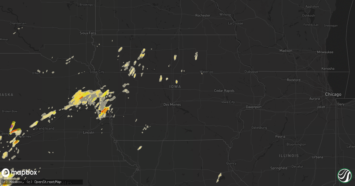
Hail Map in Iowa on September 15, 2016
Get this storm
September 15 map
$229
one time, instant access
Download today. No call, no setup
Keep the $229
Bought the map and want the full workflow? Apply the entire $229 to a subscription within 7 days. None of it is wasted.
Every map, not just this one
This buys you this map. Subscription and you get every map we run, in the markets you choose from a few cities to whole states to nationwide. Plus real-time alerts the moment a storm fires.
Contact data
Name, contact info, occupancy, even credit band for addresses in the footprint. You go from where it hit to who to call.
Become the source they trust
Unlimited branding weather history reports on demand. You already have the documented answer ready for the property owner, and you are the one who showed up with it.
Property data and RoofTrace estimates
Pull up any address you have got, its value and the exact code rules for that jurisdiction, straight from One Click Code. Then RoofTrace estimates the squares, pitch, and roof value, priced the way you price.
Storm reports in Iowa
Iowa
| Date | Description |
|---|---|
| 09/15/20166:23 PM CDT | A local report indicates 1.50 inch wind near 1 SW BLENCOE |
| 09/15/20166:10 PM CDT | 58-66 mph gusts measured with hand held instrument. Several 2 inch diameter tree limbs down. |
| 09/15/20161:32 AM CDT | Measured by sidney rwis at i-29 and hwy 2. |
| 09/14/201611:32 PM CDT | A large tree branch fell on top of power line on main street. The power line then ended up on a house. |
| 09/14/20168:03 PM CDT | . |
| 09/14/20167:35 PM CDT | Minor tree damage reported. |
All States Impacted by Hail Map on September 15, 2016
Cities Impacted by Hail Map on September 15, 2016
- Sedalia, MO
- Cole Camp, MO
- Gould, OK
- Rockham, SD
- Laurel, NE
- Crowell, TX
- Vernon, TX
- Amherst, NE
- Lexington, NE
- Elm Creek, NE
- Overton, NE
- Kearney, NE
- Tecumseh, OK
- Macomb, OK
- Hawley, TX
- Curlew, IA
- Mallard, IA
- Emmetsburg, IA
- Laurens, IA
- Havelock, IA
- Anton, CO
- Tinnie, NM
- Picacho, NM
- Carson, IA
- Tekamah, NE
- Hayes Center, NE
- Salt Flat, TX
- Dell City, TX
- Lenox, IA
- Minco, OK
- Anadarko, OK
- Corona, NM
- Denver City, TX
- Plains, TX
- Levant, KS
- Old Glory, TX
- Aspermont, TX
- Walnut, KS
- Hepler, KS
- Uniontown, KS
- Eldorado, OK
- Quanah, TX
- Deer Trail, CO
- Sweet Springs, MO
- Blackburn, MO
- Marshall, MO
- Bayard, NE
- Bridgeport, NE
- Dalton, NE
- Moran, TX
- McDonald, KS
- Atwood, KS
- Tahoka, TX
- Sac City, IA
- Lenora, KS
- Oakley, KS
- Culbertson, NE
- Palisade, NE
- Edison, NE
- Hendley, NE
- Oxford, NE
- Arapahoe, NE
- Beaver City, NE
- Woodston, KS
- Holdrege, NE
- Funk, NE
- Loomis, NE
- Omaha, NE
- Cordell, OK
- Colony, OK
- Valley, NE
- Waterloo, NE
- Elkhorn, NE
- Capitan, NM
- Hondo, NM
- Arriba, CO
- Flagler, CO
- Van Horn, TX
- Saint Francis, KS
- Norton, KS
- Chanute, KS
- Benedict, KS
- Ransom, KS
- Hoxie, KS
- Willard, NM
- Alamogordo, NM
- High Rolls Mountain Park, NM
- Locust Grove, AR
- Quinter, KS
- Nevada, MO
- Richards, MO
- Moundville, MO
- Boelus, NE
- Dannebrog, NE
- Cairo, NE
- Ravenna, NE
- Council Bluffs, IA
- La Luz, NM
- Wray, CO
- Otis, CO
- Akron, CO
- Goodell, IA
- Alexander, IA
- Thornton, IA
- Meservey, IA
- Belmond, IA
- Sterling, CO
- Cloudcroft, NM
- Bertrand, NE
- Moran, KS
- Elsmore, KS
- Humboldt, KS
- Erie, KS
- Savonburg, KS
- Wichita Falls, TX
- Bethune, CO
- Sierra Blanca, TX
- Collyer, KS
- Wakeeney, KS
- Hill City, KS
- Bogue, KS
- Hope, NM
- Stratton, CO
- Corn, OK
- Hobbs, NM
- Paducah, TX
- Vaughn, NM
- Roswell, NM
- Newport, AR
- Selden, KS
- Rexford, KS
- Monument, KS
- Oneill, NE
- Cumberland, IA
- Villisca, IA
- Greeley, NE
- Wolbach, NE
- Eustis, NE
- Moorefield, NE
- Mayhill, NM
- Dayton, IA
- Duncombe, IA
- Lehigh, IA
- Whiteface, TX
- McCook, NE
- Maywood, NE
- Truth Or Consequences, NM
- Tuttle, OK
- Mustang, OK
- Burlington, CO
- Jefferson City, MO
- Alta, IA
- Kirwin, KS
- Agra, KS
- Herman, NE
- Lyons, NE
- Decatur, NE
- Craig, NE
- West Point, NE
- Oakland, NE
- Bent, NM
- Mescalero, NM
- Tularosa, NM
- Benkelman, NE
- Byers, CO
- Bono, AR
- Goodland, KS
- Kanorado, KS
- Honey Creek, IA
- Brownfield, TX
- Loop, TX
- Seagraves, TX
- Belen, NM
- Levelland, TX
- Ropesville, TX
- Wolfforth, TX
- Lubbock, TX
- Radcliffe, IA
- McCallsburg, IA
- Roland, IA
- Stanhope, IA
- Fort Calhoun, NE
- Artesia, NM
- Scribner, NE
- Hooper, NE
- Uehling, NE
- Lamesa, TX
- Kennard, NE
- Bennington, NE
- Washington, NE
- Blair, NE
- Encino, NM
- Bessie, OK
- Foss, OK
- Clinton, OK
- Boys Town, NE
- Logan, KS
- Stockton, KS
- Palco, KS
- Phillipsburg, KS
- Damar, KS
- Clarkson, NE
- Arlington, NE
- Jarales, NM
- Dodge, NE
- Howells, NE
- Electra, TX
- Farnam, NE
- Curtis, NE
- Stockville, NE
- Paris, MO
- Stoutsville, MO
- Santa Fe, MO
- Columbus, NE
- Clarion, IA
- Carlsbad, NM
- Sumner, NE
- Oconto, NE
- Athol, KS
- Blencoe, IA
- Little Sioux, IA
- Onawa, IA
- Vinson, OK
- Mora, MO
- Albert City, IA
- Fredonia, KS
- Galva, IA
- Holstein, IA
- Clayton, KS
- Morland, KS
- Jennings, KS
- Littlefield, TX
- Jacksonville, IL
- Missouri Valley, IA
- Madison, NE
- Seymour, TX
- Throckmorton, TX
- Stamford, TX
- Haskell, TX
- Rule, TX
- Houston, MO
- Early, IA
- Storm Lake, IA
- Nemaha, IA
- Newell, IA
- Colby, KS
- Edson, KS
- Gem, KS
- Brewster, KS
- Saint Paul, NE
- Palmer, NE
- Holloman Air Force Base, NM
- Schuyler, NE
- Monticello, NM
- Lake View, IA
- Monroe City, MO
- Lovington, NM
- Hartley, IA
- Primghar, IA
- Lawrence, NE
- Nelson, NE
- Maryville, MO
- Ravenwood, MO
- Cisco, TX
- Genoa, CO
- Santa Rosa, NM
- Gorham, KS
- Russell, KS
- Creston, NE
- Pilger, NE
- Stanton, NE
- Wisner, NE
- Leigh, NE
- Beemer, NE
- Murdock, NE
- Weeping Water, NE
- Mountainair, NM
- Andrews, TX
- Eunice, NM
- North Bend, NE
- Stark, KS
- Anton, TX
- Modale, IA
- Mondamin, IA
- Vona, CO
- Fort Davis, TX
- Orchard, NE
- Beech Grove, AR
- Corning, IA
- Hale Center, TX
- Ira, TX
- Rock Valley, IA
- Deming, NM
- Gregory, SD
- Springfield, NE
- Dresden, KS
- Oberlin, KS
- Weed, NM
- Glade, KS
- Longton, KS
- Creighton, NE
- Winnetoon, NE
- Abernathy, TX
- Crescent, IA
- Marble Hill, MO
- Hoisington, KS
- Clarksville, IA
- Greene, IA
- Wilson, TX
- Brush, CO
- Wilsonville, NE
- Howard, KS
- Fall River, KS
- Magnolia, IA
- Pisgah, IA
- Nickerson, NE
- Logan, IA
- Moorhead, IA
- Woodbine, IA
- Dunlap, IA
- Bancroft, NE
- Fremont, NE
- Humphrey, NE
- Platte Center, NE
- Genoa, NE
- Snyder, NE
- Soldier, IA
- Gretna, NE
- Monroe, NE
- Winslow, NE
- Rogers, NE
- Iowa Park, TX
- Black Hawk, SD
- Milnesand, NM
- Springfield, SD
- Avon, SD
- Cord, AR
- Aurelia, IA
- Lindon, CO
- Prairie View, KS
- Champion, NE
- Clarks, NE
- Central City, NE
- Stamford, NE
- Penokee, KS
- Lebanon, MO
- Holts Summit, MO
- Cedar Rapids, NE
- Orleans, NE
- Avoca, NE
- Jolley, IA
- Rockwell City, IA
- Jayton, TX
- Woodrow, CO
- Fort Morgan, CO
- Gaylord, KS
- Fullerton, NE
- Snyder, TX
- Aurora, MO
- Ashton, IA
- Ackerly, TX
- Buffalo, KS
- Magdalena, NM
- Denison, IA
- Shallowater, TX
- Fort Scott, KS
- La Harpe, KS
- Saint Paul, KS
- Redfield, KS
- Pender, NE
- Cope, CO
- Berryton, KS
- West Plains, MO
- Newark, AR
- Crossroads, NM
- Alma, NE
- Norcatur, KS
- Oklahoma City, OK
- Strasburg, CO
- Elwood, NE
- Manson, IA
- Hollis, OK
- Norman, OK
- Dadeville, MO
- Ogallah, KS
- Eddyville, NE
- Riverdale, NE
- Hudson, IA
- Cedar Falls, IA
- Nelson, MO
- Heber Springs, AR
- Pangburn, AR
- Dixon, NE
- Grandin, MO
- Doniphan, MO
- Walnut Ridge, AR
- Gravity, IA
- Sharpsburg, IA
- Kirkman, IA
- Irwin, IA
- Shelby, NE
- Rising City, NE
- Rapid City, SD
- Hughesville, MO
- Prescott, IA
- Sidney, NE
- Beebe, AR
- Otis, KS
- Crofton, NE
- Saint Helena, NE
- Fordyce, NE
- Yankton, SD
- Paullina, IA
- Larrabee, IA
- Woolstock, IA
- Benton, MO
- Scott City, MO
- Pinon, NM
- Smith Center, KS
- Olmitz, KS
- Albert, KS
- Cedar, KS
- Kensington, KS
- Allen, NE
- Manilla, IA
- Rockville, NE
- Baird, TX
- Smithfield, NE
- Elida, NM
- Holbrook, NE
- Arion, IA
- Fleming, CO
- Iowa Falls, IA
- Smyer, TX
- Whittemore, IA
- Chapin, IL
- Seibert, CO
- Gove, KS
- Natoma, KS
- Paradise, KS
- Ashland, NE
- Yutan, NE
- Pomeroy, IA
- Pocahontas, IA
- Palmer, IA
- Shelton, NE
- Archer, NE
- Saint Libory, NE
- Chapman, NE
- Gibbon, NE
- Olton, TX
- Mission Hill, SD
- Randlett, OK
- Bosque, NM
- Fonda, IA
- Atlanta, NE
- Odebolt, IA
- Schaller, IA
- Saint Thomas, MO
- Ellis, KS
- Yukon, MO
- Elk Creek, MO
- Vail, IA
- Deloit, IA
- Kiron, IA
- Lebanon, NE
- Slaton, TX
- Osceola, NE
- Pickering, MO
- Hart, TX
- Fort Dodge, IA
- Clare, IA
- Meriden, IA
- Hume, MO
- Carnegie, OK
- Hydro, OK
- Charles City, IA
- Ruidoso, NM
- Lebanon, KS
- La Joya, NM
- Belgrade, NE
- Saint Edward, NE
- Page, NE
- Summersville, MO
- Pukwana, SD
- Chamberlain, SD
- Rembrandt, IA
- Miller, NE
- Broken Bow, NE
- Mason City, NE


