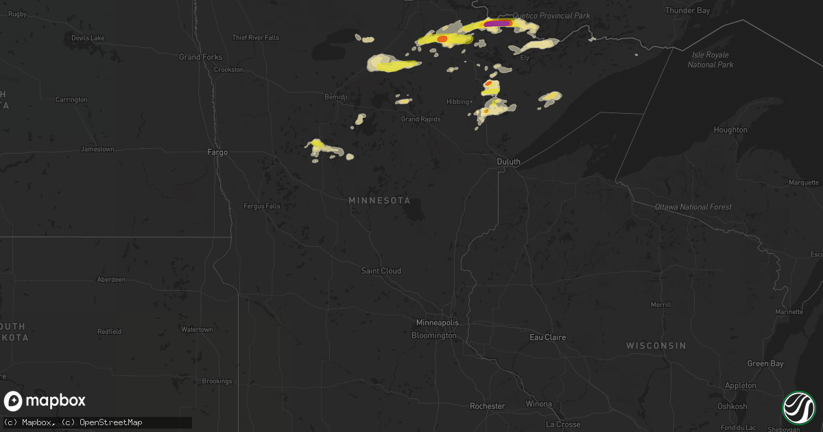
Hail Map in Minnesota on September 14, 2017
Get this storm
September 14 map
$229
one time, instant access
Download today. No call, no setup
Keep the $229
Bought the map and want the full workflow? Apply the entire $229 to a subscription within 7 days. None of it is wasted.
Every map, not just this one
This buys you this map. Subscription and you get every map we run, in the markets you choose from a few cities to whole states to nationwide. Plus real-time alerts the moment a storm fires.
Contact data
Name, contact info, occupancy, even credit band for addresses in the footprint. You go from where it hit to who to call.
Become the source they trust
Unlimited branding weather history reports on demand. You already have the documented answer ready for the property owner, and you are the one who showed up with it.
Property data and RoofTrace estimates
Pull up any address you have got, its value and the exact code rules for that jurisdiction, straight from One Click Code. Then RoofTrace estimates the squares, pitch, and roof value, priced the way you price.
Storm reports in Minnesota
Minnesota
| Date | Description |
|---|---|
| 09/14/20176:38 PM CDT | Largest hailstones were 1.5 inches in diameter. Time estimated from radar. |
| 09/14/20176:35 PM CDT | Time estimated from radar. |
| 09/14/20176:33 PM CDT | A few 3 to 4 inch diameter trees downed blocking the south bound side of highway 53...near murphy lake road. Time estimated from radar. |
| 09/14/20176:19 PM CDT | Hail duration of approximately 5 minutes. Largest hailstones were quarter sized. |
| 09/14/20176:10 PM CDT | A local report indicates 1.00 inch wind near BIWABIK |
| 09/14/20175:48 PM CDT | Hail began at approximately 534 pm and ended at 548 pm. The largest hailstones were golf ball sized. |
| 09/14/20174:01 PM CDT | Time estimated from radar. |
| 09/14/20174:00 PM CDT | Time estimated from radar. |
| 09/14/20174:00 PM CDT | South side of crane lake |
| 09/13/20179:40 PM CDT | Hail on fifth crow wing lake. Time estimated based on radar. |
| 09/13/20178:49 PM CDT | A local report indicates 1.00 inch wind near 5 W PARK RAPIDS |
| 09/13/20178:28 PM CDT | Nickel to quarter sized hail. |
All States Impacted by Hail Map on September 14, 2017
Cities Impacted by Hail Map on September 14, 2017
- Winner, SD
- Thompson, UT
- Menahga, MN
- Saint Johns, AZ
- Gruver, TX
- Escalante, UT
- Deer River, MN
- Chambers, AZ
- Orlando, FL
- Orr, MN
- Littlefield, AZ
- Amherst, CO
- Big Falls, MN
- Littlefork, MN
- Crane Lake, MN
- Saint Francis, KS
- Gilbert, MN
- Biwabik, MN
- Aurora, MN
- Embarrass, MN
- Virginia, MN
- Ely, MN
- Burlington, CO
- Kimballton, IA
- Irwin, IA
- Kirkman, IA
- Harlan, IA
- Kanab, UT
- Orderville, UT
- Makinen, MN
- Wallace, NE
- Wauneta, NE
- Isabella, MN
- Finland, MN
- Denison, IA
- Northome, MN
- Effie, MN
- Wirt, MN
- Bigfork, MN
- Colorado City, AZ
- Apopka, FL
- Altamonte Springs, FL
- Maitland, FL
- Backus, MN
- Nevis, MN
- Stapleton, NE
- Park Rapids, MN
- Thedford, NE
- Springview, NE
- Waskish, MN
- Kelliher, MN
- Champion, NE
- Tower, MN
- Babbitt, MN
- Soudan, MN
- Rupert, ID
- Cass Lake, MN
- Saint George, UT
- Curtis, NE
- Moorefield, NE
- Maxwell, NE
- Maywood, NE
- Tucumcari, NM
- Cubero, NM
- Mesquite, NV
- Williams, AZ
- Forbes, MN
- Eveleth, MN
- Cook, MN
- Conchas Dam, NM
- Manilla, IA
- Ainsworth, NE
- Osage, MN
- Silver Bay, MN
- Arthur, IA
- Laguna, NM
- Brady, NE
- Walker, MN
- Laporte, MN
- Kimball, SD
- Audubon, IA
- Ganado, AZ
- Cotton, MN
- Angora, MN
- Dallas, SD
- Colome, SD
- Overton, NV
- Iron, MN
- Mountain Iron, MN
- Imperial, NE
- Stratton, NE
- Grand Marais, MN
- Kaibeto, AZ
- Spearman, TX
- Hayes Center, NE
- Arnold, NE
- Mizpah, MN
- Pie Town, NM
- Blackduck, MN
- North Platte, NE
- Trementina, NM
- Venango, NE
- Ponsford, MN
- Akeley, MN
- Monticello, UT
- Woodbine, IA
- Hamlin, IA
- Hibbing, MN
- Colwich, KS


