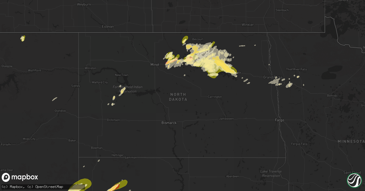
Hail Map in North Dakota on September 11, 2025
Get this storm
September 11 map
$229
one time, instant access
Download today. No call, no setup
Keep the $229
Bought the map and want the full workflow? Apply the entire $229 to a subscription within 7 days. None of it is wasted.
Every map, not just this one
This buys you this map. Subscription and you get every map we run, in the markets you choose from a few cities to whole states to nationwide. Plus real-time alerts the moment a storm fires.
Contact data
Name, contact info, occupancy, even credit band for addresses in the footprint. You go from where it hit to who to call.
Become the source they trust
Unlimited branding weather history reports on demand. You already have the documented answer ready for the property owner, and you are the one who showed up with it.
Property data and RoofTrace estimates
Pull up any address you have got, its value and the exact code rules for that jurisdiction, straight from One Click Code. Then RoofTrace estimates the squares, pitch, and roof value, priced the way you price.
Storm reports in North Dakota
North Dakota
| Date | Description |
|---|---|
| 09/11/20253:15 PM CDT | Estimated hail size with a few stones up to a quarter in size. |
| 09/11/20253:27 AM CDT | A local report indicates 1.75 inch wind near 4 E Doyon |
| 09/11/20253:20 AM CDT | A local report indicates 1.00 inch wind near Doyon |
| 09/11/20253:10 AM CDT | Report relayed via broadcast media: handful of quarter sized hail with one stone closer to 1.25 to 1.5 inches. |
| 09/11/20253:10 AM CDT | Report relayed via broadcast media: handful of quarter sized hail with one stone closer to 1.25 |
| 09/11/20252:40 AM CDT | Hail fell for 4 to 5 minutes with the ground becoming completely covered. The largest stones were larger than a quarter. |
| 09/11/20251:40 AM CDT | Facebook report: time estimated via radar. |
| 09/11/20251:35 AM CDT | Facebook report: time estimated via radar. Handful of nickel to quarters with one larger stone of at least half dollar size. |
| 09/11/20251:30 AM CDT | Corrects previous hail report from leeds. Facebook report: time estimated via radar. Handful of nickel to quarters with one larger stone of at least half dollar size. |
| 09/10/202510:30 PM CDT | Hail report from thursday |
| 09/10/20259:41 PM CDT | Member of the public reports hail estimated to be around 2 inches in diameter. Still hailing at the time of the report. |
| 09/10/20259:30 PM CDT | Member of the public shares photo of hailstones estimated to be a quarter in size. Hail started around 9:30 and fell for approximately 15 minutes. Photo relayed on soci |
| 09/10/20259:30 PM CDT | Member of the public shared a photo of a hailstone estimated to be around the size of a half-dollar. Photo relayed on social media. |
| 09/10/20259:27 PM CDT | Broadcast media relays photo on social media of 2 inch hail near granville. |
| 09/10/20259:24 PM CDT | Broadcast media relays photo on social media of quarter sized hail near granville. |
All States Impacted by Hail Map on September 11, 2025
Cities Impacted by Hail Map on September 11, 2025
- Pine Bluffs, WY
- Bushnell, NE
- Harrisburg, NE
- Willow City, ND
- Rolette, ND
- Dunseith, ND
- Rugby, ND
- Mylo, ND
- Wolford, ND
- Belcourt, ND
- Agate, ND
- York, ND
- Bisbee, ND
- Perth, ND
- Egeland, ND
- Rocklake, ND
- Leeds, ND
- Cando, ND
- Ludlow, SD
- Starkweather, ND
- Minnewaukan, ND
- Munich, ND
- Maddock, ND
- Churchs Ferry, ND
- Hampden, ND
- Penn, ND
- Edmore, ND
- Webster, ND
- Devils Lake, ND
- Crary, ND
- Lawton, ND
- Hereford, AZ
- Grover, CO
- Miami, FL
- Mccall, ID
- Hialeah, FL
- Pulaski, TN
- Prospect, TN
- Durango, CO
- Saint David, AZ
- Bennett, CO
- Vail, AZ
- Benson, AZ
- Watkins, CO
- Strasburg, CO
- Oak Grove, LA
- Bayfield, CO
- Minor Hill, TN
- Lester, AL
- Goodspring, TN
- Peerless, MT
- Bloomfield, MT
- Anderson, AL
- Glendive, MT
- Athens, AL
- Rogersville, AL
- Wallowa, OR
- Elkmont, AL
- Richland, MT
- Alsen, ND
- Anaconda, MT
- Osnabrock, ND
- Harrison, NE
- Torrington, WY
- Peridot, AZ
- Carpenter, WY
- New Raymer, CO
- Twin Falls, ID
- Manhattan, MT
- Milton, ND
- Three Forks, MT
- Kimball, NE
- Crawford, NE
- Tuscumbia, AL
- Syracuse, KS
- Kendall, KS
- Russellville, AL
- Edgemont, SD
- Whitney, NE
- Oelrichs, SD
- Chadron, NE
- Hot Springs, SD
- Cypress Inn, TN
- Florence, AL
- Oral, SD
- Smithwick, SD
- Waterloo, AL
- Whitewood, SD
- Granville, ND
- Belle Fourche, SD
- Spearfish, SD
- Saint Onge, SD
- Nisland, SD
- Vale, SD
- Sturgis, SD
- Bath Springs, TN
- Scotts Hill, TN
- Newell, SD
- Saltillo, TN
- Savannah, TN
- Custer, SD
- Norwich, ND
- Kamiah, ID
- Mud Butte, SD
- Rapid City, SD
- Towner, ND
- Prairie City, SD
- Bison, SD
- Meadow, SD
- Faith, SD
- Bantry, ND
- Upham, ND
- Stites, ID
- Kooskia, ID
- Bridger, MT
- Gillette, WY
- Union Center, SD
- Lodge Grass, MT
- Karlsruhe, ND
- Velva, ND
- Deering, ND
- Esmond, ND
- Bottineau, ND
- Knox, ND
- Alzada, MT
- Buffalo, SD
- Camp Crook, SD
- Oberon, ND
- Hensel, ND
- Lakota, ND
- Saint Michael, ND
- Fort Totten, ND
- Sheyenne, ND
- Michigan, ND
- Mcville, ND
- Aneta, ND
- Petersburg, ND
- Northwood, ND
- Niagara, ND
- Minto, ND
- Killdeer, ND
- Manning, ND
- Thompson, ND
- Grand Forks, ND
- Dunn Center, ND
- East Grand Forks, MN
- Max, ND
- Fisher, MN
- Crookston, MN
- Climax, MN
- Mandaree, ND
- Red Lake Falls, MN
- Beltrami, MN
- Mentor, MN
- Plummer, MN
- Trail, MN
- Mcintosh, MN
- Anamoose, ND


