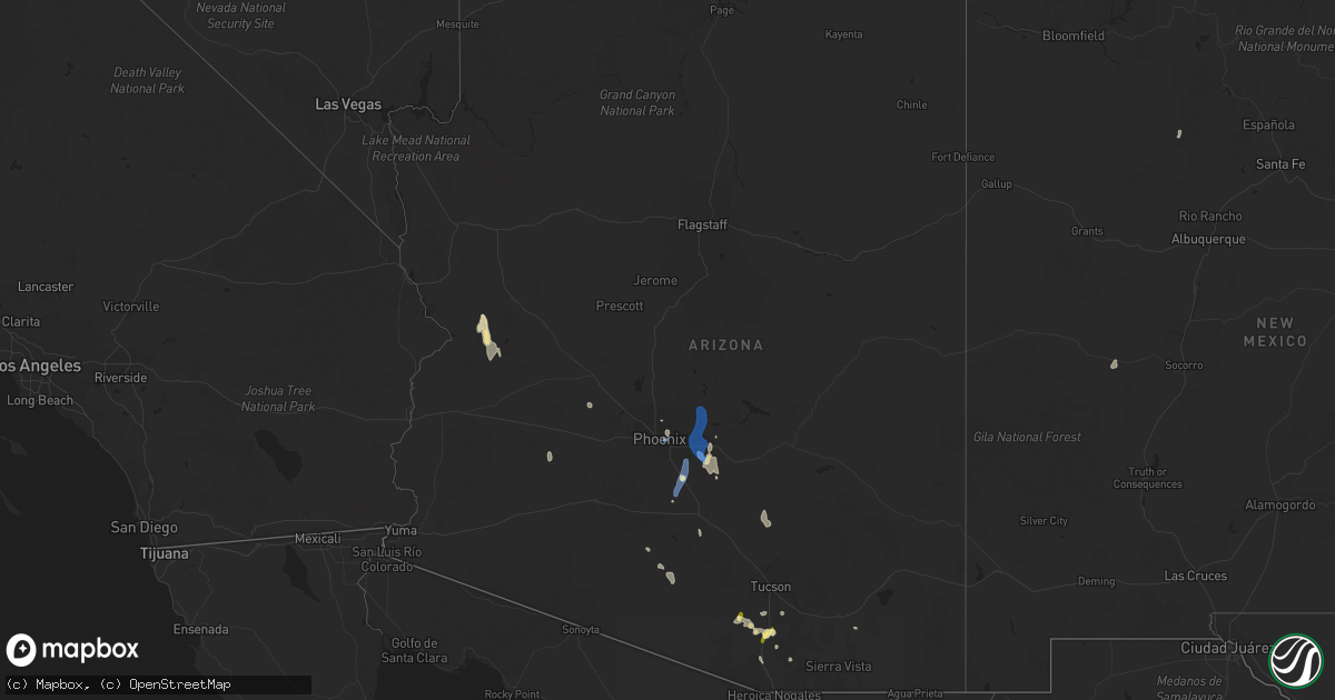
Hail Map in Arizona on September 11, 2022
Get this storm
September 11 map
$229
one time, instant access
Download today. No call, no setup
Keep the $229
Bought the map and want the full workflow? Apply the entire $229 to a subscription within 7 days. None of it is wasted.
Every map, not just this one
This buys you this map. Subscription and you get every map we run, in the markets you choose from a few cities to whole states to nationwide. Plus real-time alerts the moment a storm fires.
Contact data
Name, contact info, occupancy, even credit band for addresses in the footprint. You go from where it hit to who to call.
Become the source they trust
Unlimited branding weather history reports on demand. You already have the documented answer ready for the property owner, and you are the one who showed up with it.
Property data and RoofTrace estimates
Pull up any address you have got, its value and the exact code rules for that jurisdiction, straight from One Click Code. Then RoofTrace estimates the squares, pitch, and roof value, priced the way you price.
Storm reports in Arizona
Arizona
| Date | Description |
|---|---|
| 09/11/20224:09 AM CDT | At 909 PM MST, a severe thunderstorm was located over East Mesa, moving northwest at 20 mph. HAZARD...60 mph wind gusts. SOURCE...Radar indicated. IMPACT...Expect damage to roofs, siding, and trees. Locations impacted include... Mesa, Apache Junction, East Mesa, Granite Reef Dam and Usery Mountain Park.This includes the following highways...US Highway 60 between mile markers 189 and 193.AZ Route 202 between mile markers 22 and 31. |
| 09/11/20224:03 AM CDT | At 903 PM MST, a severe thunderstorm was located near Tolleson, moving northwest at 20 mph. HAZARD...60 mph wind gusts and penny size hail. SOURCE...Radar indicated. IMPACT...Expect damage to roofs, siding, and trees. Locations impacted include... Avondale, Goodyear, Tolleson, Cashion, Litchfield Park, Phoenix International Raceway, Camelback Ranch, Estrella Mountain Park and Komatke.This includes the following highways...AZ Interstate 10 between mile markers 129 and 134.AZ Route 101 near mile marker 2. |
| 09/11/20223:54 AM CDT | At 854 PM MST, a severe thunderstorm was located over Papago Park, or near Tempe, moving northwest at 20 mph. HAZARD...70 mph wind gusts and penny size hail. SOURCE...Radar indicated. IMPACT...Expect considerable tree damage. Damage is likely to mobile homes, roofs, and outbuildings. Locations impacted include... Phoenix, Mesa, Glendale, Scottsdale, Gilbert, Tempe, Paradise Valley, Tolleson, Laveen, Sun City, Tempe Marketplace, Papago Park, Piestewa Peak Park, Deer Valley Airport and Falcon Field Airport.This includes the following highways...AZ Interstate 10 between mile markers 135 and 157.AZ Interstate 17 between mile markers 195 and 216.AZ Route 51 between mile markers 1 and 15. |
| 09/11/20223:48 AM CDT | At 848 PM MST, a severe thunderstorm was located near San Tan Valley, or 10 miles southwest of Gold Canyon, moving north at 15 mph. HAZARD...60 mph wind gusts and quarter size hail. SOURCE...Radar indicated. IMPACT...Hail damage to vehicles is expected. Expect wind damage to roofs, siding, and trees. Locations impacted include... Mesa, Apache Junction, Gold Canyon, Queen Creek, Blackwater, Gold Camp, San Tan Mountain Park, Magma and San Tan Valley.This includes the following highways...US Highway 60 between mile markers 194 and 210.AZ Route 202 between mile markers 32 and 35. |
| 09/11/20223:22 AM CDT | At 822 PM MST, a severe thunderstorm was located 8 miles southwest of Freeman, or 24 miles southeast of Gila Bend, moving northwest at 20 mph. HAZARD...60 mph wind gusts and quarter size hail. SOURCE...Radar indicated. IMPACT...Hail damage to vehicles is expected. Expect wind damage to roofs, siding, and trees. Locations impacted include... Estrella, Freeman, Big Horn, Bosque, Estrella Sailport, Sonoran National Monument and Mobile.This includes the following highways...AZ Interstate 8 between mile markers 123 and 154.AZ Route 238 between mile markers 4 and 37. |
| 09/11/20223:11 AM CDT | At 811 PM MST, a severe thunderstorm was located near Bapchule, or near Sun Lakes, moving north at 15 mph. HAZARD...60 mph wind gusts and quarter size hail. SOURCE...Radar indicated. IMPACT...Hail damage to vehicles is expected. Expect wind damage to roofs, siding, and trees. Locations impacted include... Mesa, Chandler, Gilbert, Tempe, Sun Lakes, Queen Creek, Chandler Heights, Gilbert City Hall, Tumbleweed Park, Chandler City Hall, San Tan Village Mall, Seville, Freestone Park, Chandler Fashion Center Mall and Phoenix Mesa Gateway Airport.This includes the following highways...AZ Interstate 10 between mile markers 158 and 173.AZ Route 87 between mile markers 155 and 170.AZ Route 202 between mile markers 36 and 55. |
| 09/11/20222:44 AM CDT | At 744 PM MST, a severe thunderstorm was located 10 miles southeast of Maricopa, or 12 miles west of Casa Grande, moving north at 15 mph. HAZARD...60 mph wind gusts and quarter size hail. SOURCE...Radar indicated. IMPACT...Hail damage to vehicles is expected. Expect wind damage to roofs, siding, and trees. Locations impacted include... Casa Grande, Maricopa, Bapchule, Olberg, Stanfield, Ak- Chin Village, Sacaton and Santan.This includes the following highways...AZ Interstate 10 between mile markers 174 and 188.AZ Interstate 8 between mile markers 155 and 174.AZ Route 87 between mile markers 149 and 154. |
| 09/11/20222:42 AM CDT | At 742 PM MST, a severe thunderstorm was located near Green Valley, moving northwest at 5 mph. HAZARD...60 mph wind gusts and quarter size hail. SOURCE...Radar indicated. IMPACT...Hail damage to vehicles is expected. Expect wind damage to roofs, siding, and trees. Locations impacted include... Sahuarita, Green Valley and East Sahuarita. |
| 09/11/20222:01 AM CDT | At 701 PM MST, a severe thunderstorm was located near Three Points, or 18 miles northwest of Green Valley, moving northwest at 10 mph. HAZARD...60 mph wind gusts and quarter size hail. SOURCE...Radar indicated. IMPACT...Hail damage to vehicles is expected. Expect wind damage to roofs, siding, and trees. Locations impacted include... Three Points. |
| 09/11/20221:53 AM CDT | At 653 PM MST, a severe thunderstorm was located 14 miles northwest of Saddlebrooke, or 15 miles west of Oracle, moving northwest at 15 mph. HAZARD...60 mph wind gusts and quarter size hail. SOURCE...Radar indicated. IMPACT...Hail damage to vehicles is expected. Expect wind damage to roofs, siding, and trees. This severe thunderstorm will remain over mainly remote areas of south central Pinal County. |
| 09/11/20221:44 AM CDT | At 643 PM MST, a severe thunderstorm was located 7 miles northeast of Santa Rosa, or 33 miles north of Sells, moving northwest at 15 mph. HAZARD...60 mph wind gusts and quarter size hail. SOURCE...Radar indicated. IMPACT...Hail damage to vehicles is expected. Expect wind damage to roofs, siding, and trees. Locations impacted include... Santa Rosa, Chui-Chu, Anegam, North Komelik, Kohatk, Palo Verde Stand, Ventana, Ak Chin, Jack Rabbit, Shopishk, San Luis, Santa Rosa School and East Chui-Chu. |
| 09/11/20221:09 AM CDT | At 609 PM MST, a severe thunderstorm was located 9 miles west of Green Valley, and is nearly stationary. HAZARD...60 mph wind gusts and quarter size hail. SOURCE...Radar indicated. IMPACT...Hail damage to vehicles is expected. Expect wind damage to roofs, siding, and trees. Locations impacted include... Three Points. |
| 09/11/20221:02 AM CDT | At 602 PM MST, severe thunderstorms were located along a line extending from 19 miles southwest of Avra Valley to near Santa Rosa, moving north at 10 mph. HAZARD...60 mph wind gusts and quarter size hail. SOURCE...Radar indicated. IMPACT...Hail damage to vehicles is expected. Expect wind damage to roofs, siding, and trees. Locations impacted include... Santa Rosa, Anegam, Palo Verde Stand, Ak Chin, Queens Well, Sil Nakya, San Luis and Silver Bell. |
| 09/11/20221:00 AM CDT | At 600 PM MST, a severe thunderstorm was located near Mount Lemmon/Summerhaven, or near Catalina, moving northwest at 25 mph. HAZARD...60 mph wind gusts and quarter size hail. SOURCE...Radar indicated. IMPACT...Hail damage to vehicles is expected. Expect wind damage to roofs, siding, and trees. Locations impacted include... Catalina, Oracle, Saddlebrooke, Mount Lemmon/Summerhaven, Campo Bonito, Oracle Junction and Biosphere 2. |
| 09/11/202212:53 AM CDT | At 552 PM MST, a severe thunderstorm was located over Green Valley, and is nearly stationary. HAZARD...60 mph wind gusts and quarter size hail. SOURCE...Radar indicated. IMPACT...Hail damage to vehicles is expected. Expect wind damage to roofs, siding, and trees. Locations impacted include... Sahuarita, Green Valley, East Sahuarita and Arivaca Junction. |
| 09/11/202212:04 AM CDT | Trees uprooted or snapped; roof blown off. |
| 09/10/202211:55 PM CDT | Trees uprooted or snapped; roof blown off. |
| 09/10/202211:18 PM CDT | Social media picture showed large tree uprooted onto an apartment complex located between camelback road and 16th st. |
| 09/10/202211:15 PM CDT | Awos station kffz mesa falcon fld. |
| 09/10/202211:12 PM CDT | 1-inch tree limbs broken; shingles blown off. |
| 09/10/202211:11 PM CDT | 3-inch tree limbs broken; power poles broken. |
| 09/10/202211:09 PM CDT | 3-inch tree limbs broken; power poles broken. |
| 09/10/202210:58 PM CDT | Awos station kiwa mesa gateway airport. |
| 09/10/202210:57 PM CDT | Corrects previous tstm wnd gst report from sky harbor airport. |
| 09/10/202210:53 PM CDT | Corrects previous tstm wnd gst report from sky harbor airport. Corrects previous tstm wnd gst report from sky harbor airport. |
| 09/10/202210:52 PM CDT | Asos station kphx phoenix sky hrbr. |
| 09/10/202210:50 PM CDT | 3-inch tree limbs broken; power poles broken. |
| 09/10/202210:30 PM CDT | Heavy rain 0.75 in. Measured in 25 minutes. |
| 09/10/202210:24 PM CDT | Awos station kchd chandler. |
| 09/10/202210:04 PM CDT | Retired nws employee reports 1 inch hail stones southeast of green valley... Az. |
| 09/10/20229:55 PM CDT | Awos station ka39 ak-chin. |
| 09/10/20227:55 PM CDT | Trained spotter reports 1 inch size hail stones in green valley az. |
All States Impacted by Hail Map on September 11, 2022
Cities Impacted by Hail Map on September 11, 2022
- Sonoita, AZ
- Apache Junction, AZ
- San Tan Valley, AZ
- Amado, AZ
- Green Valley, AZ
- Tucson, AZ
- Yucca, AZ
- Coolidge, AZ
- Bapchule, AZ
- Eloy, AZ
- Sells, AZ
- Magdalena, NM
- Tonopah, AZ
- Buckeye, AZ
- Queen Creek, AZ
- Mesa, AZ
- Sahuarita, AZ
- Salome, AZ
- Tumacacori, AZ
- Tubac, AZ
- Paradise Valley, AZ
- Phoenix, AZ
- Stanfield, AZ
- Jemez Springs, NM
- Casa Grande, AZ
- Saint David, AZ
- Wittmann, AZ
- Avon Park, FL
- Florence, AZ
- Chandler, AZ
- Maricopa, AZ
- Gilbert, AZ
- Fort Mcdowell, AZ
- Fountain Hills, AZ
- Scottsdale, AZ


