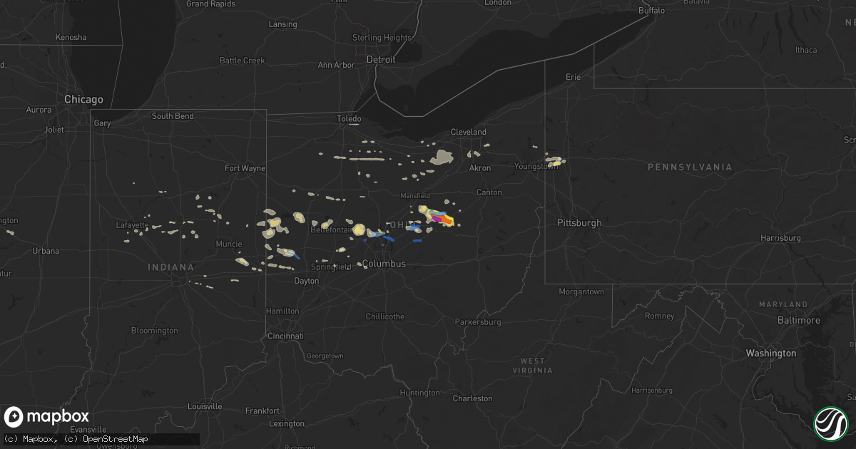
Hail Map in Ohio on September 7, 2020
Get this storm
September 7 map
$229
one time, instant access
Download today. No call, no setup
Keep the $229
Bought the map and want the full workflow? Apply the entire $229 to a subscription within 7 days. None of it is wasted.
Every map, not just this one
This buys you this map. Subscription and you get every map we run, in the markets you choose from a few cities to whole states to nationwide. Plus real-time alerts the moment a storm fires.
Contact data
Name, contact info, occupancy, even credit band for addresses in the footprint. You go from where it hit to who to call.
Become the source they trust
Unlimited branding weather history reports on demand. You already have the documented answer ready for the property owner, and you are the one who showed up with it.
Property data and RoofTrace estimates
Pull up any address you have got, its value and the exact code rules for that jurisdiction, straight from One Click Code. Then RoofTrace estimates the squares, pitch, and roof value, priced the way you price.
Storm reports in Ohio
Ohio
| Date | Description |
|---|---|
| 09/07/20206:48 PM CDT | Tree down on south union road. Time estimated from radar. |
| 09/07/20204:54 PM CDT | A local report indicates 62 MPH wind near 5 NNW TIPP CITY |
| 09/07/20204:52 PM CDT | Numerous trees down across mount vernon. |
| 09/07/20204:48 PM CDT | Numerous trees and wires down. |
| 09/07/20204:33 PM CDT | Numerous trees downed at two properties on sinkey road. |
| 09/07/20204:30 PM CDT | Tree down near north rangeline road and west versailles road. Time estimated from radar. |
| 09/07/20204:25 PM CDT | Quarter sized hail. Time estimated via radar. |
| 09/07/20204:25 PM CDT | A local report indicates 1.00 inch wind near 2 SSW GLENMONT |
| 09/07/20204:24 PM CDT | Two large trees uprooted at a residence on north columbus street. |
| 09/07/20204:23 PM CDT | Multiple trees downed on orchard lane. |
| 09/07/20204:22 PM CDT | Multiple trees downed on mill run drive. |
| 09/07/20204:21 PM CDT | A local report indicates 1.75 inch wind near GLENMONT |
| 09/07/20204:20 PM CDT | Barn blown over and power pole snapped. Time radar estimated. |
| 09/07/20204:19 PM CDT | One large tree downed at n galena road and us route 36. |
| 09/07/20204:15 PM CDT | Several large tree limbs downed near glen oak elementary school. |
| 09/07/20204:14 PM CDT | A local report indicates 2.00 inch wind near NASHVILLE |
| 09/07/20204:13 PM CDT | Tree downed on dubois road. |
| 09/07/20204:12 PM CDT | Several large trees downed or uprooted along county road 10. Time estimated by radar. |
| 09/07/20204:12 PM CDT | Several large trees downed or snapped along leonardsburg road. Time estimated by radar. |
| 09/07/20204:12 PM CDT | Trees downed near the entry to shale hollow park. |
| 09/07/20204:12 PM CDT | Numerous large trees and tree limbs downed along a portion of cackler road. Time estimated by radar. |
| 09/07/20204:11 PM CDT | Tree damage reporterd on harris road near state route 521. |
| 09/07/20204:08 PM CDT | Several trees and wires down in and near the city of delaware. Time estimated from radar. |
| 09/07/20204:07 PM CDT | Measured on the ema weather station at the county courthouse |
| 09/07/20204:07 PM CDT | Tree reported down on power lines. Time estimated from radar. |
| 09/07/20204:04 PM CDT | Numerous trees down in knox township. One crew has cut up at least 40 trees. |
| 09/07/20203:53 PM CDT | Several large maples snapped at the 2 1/2 ft trunk level. Time estimated from radar. |
| 09/07/20203:53 PM CDT | Several large trees down near the intersection of springdale and lowe roads. One tree fell onto a house and a barn was also blown down. Time estimated from radar. |
| 09/07/20206:31 AM CDT | At 1131 PM EDT, a severe thunderstorm was located near Newport, moving east at 45 mph. HAZARD...60 mph wind gusts and penny size hail. SOURCE...Radar indicated. IMPACT...Expect damage to trees and power lines. Locations impacted include... Troy, Sidney, Piqua, Covington, Newport, Bradford, Fort Loramie, Pleasant Hill, Hardin, Russia, Fletcher, Port Jefferson, Casstown, Lockington, Polo, Newbern, Bloomer, Ballou, Plattsville and Farrington.This includes I-75 in Ohio between mile markers 74 and 97. |
| 09/07/20202:46 AM CDT | At 746 PM EDT, a severe thunderstorm was located over Dayton, moving east at 30 mph. HAZARD...60 mph wind gusts and quarter size hail. SOURCE...Radar indicated. IMPACT...Minor hail damage to vehicles is possible. Expect wind damage to trees and power lines. Locations impacted include... Dayton, Kettering, Beavercreek, Huber Heights, Fairborn, Xenia, Trotwood, Vandalia, Englewood, Moraine, Oakwood, Yellow Springs, Wright-Patterson Afb, Wilberforce, Riverside, Clayton, Shiloh, Fort Mckinley, Northview and Oldtown.This includes the following Interstates... I-70 in Ohio near mile marker 29. I-75 in Ohio between mile markers 50 and 60. |
| 09/07/20202:45 AM CDT | At 745 PM EDT, a severe thunderstorm was located near Hagerstown, moving east at 30 mph. HAZARD...60 mph wind gusts and penny size hail. SOURCE...Radar indicated. IMPACT...Expect damage to trees and power lines. Locations impacted include... Richmond, Centerville, Hagerstown, New Paris, New Madison, Fountain City, Franklin, Eldorado, Greens Fork, Spring Grove, Bethel, Hollansburg, Palestine, Economy, Whitewater, Middleboro, Interstate 70 at Exit 145 and Williamsburg.This includes the following Interstates... I-70 in Indiana between mile markers 144 and 156. I-70 in Ohio between mile markers 0 and 6. |
| 09/07/20201:28 AM CDT | At 627 PM EDT, a severe thunderstorm was located near Springfield, moving east at 30 mph. HAZARD...60 mph wind gusts and penny size hail. SOURCE...Radar indicated. IMPACT...Expect damage to trees and power lines. Locations impacted include... Springfield, London, Enon, South Charleston, Choctaw Lake, Harmony, Lisbon, Brighton, North Hampton, Lafayette, South Vienna, Tremont City, Donnelsville, Catawba, Green Meadows, Hustead, Selma, Buck Creek State Park, Springfield Municipal Airport and State Route 29 at State Route 38.This includes I-70 in Ohio between mile markers 47 and 77. |
| 09/07/20201:06 AM CDT | At 605 PM EDT, a severe thunderstorm was located 9 miles east of Utica, or 14 miles northeast of Newark, moving east at 50 mph. HAZARD...Wind gusts to 70 mph and quarter-size hail. SOURCE...Radar. IMPACT...Minor hail damage to vehicles is possible. Trees snapped and uprooted. Power outages can be expected. Locations impacted include... Zanesville... Coshocton... North Zanesville... Dresden... Frazeysburg... Warsaw... Conesville... Nellie... Norwich... Drake... New Guilford... Walhonding...This includes Interstate 70 in Ohio between mile markers 163 and 166. |
| 09/07/202012:44 AM CDT | At 543 PM EDT, severe thunderstorms were located along a line extending from near Millersburg to near Killbuck, moving east at 30 mph. HAZARD...60 mph wind gusts and quarter size hail. SOURCE...Radar indicated. IMPACT...Minor damage to vehicles is possible. Expect damage to trees and power lines. Locations impacted include... Millersburg, Killbuck, Farmerstown, Baltic and Charm. |
| 09/07/202012:37 AM CDT | At 535 PM EDT, a severe thunderstorm was located near Centerburg, moving southeast at 45 mph. A Tornado Warning remains in effect for western and central Licking County through 600 PM EDT. HAZARD...60 mph wind gusts. SOURCE...Radar indicated. IMPACT...Expect damage to trees and power lines. Locations impacted include... Newark, Heath, Granville, Johnstown, Sunbury, Buckeye Lake, Hebron, Utica, Hanover, Harbor Hills, Granville South, Marne, Thornport, Galena, Alexandria, Hartford, St. Louisville, Gratiot, US Route 62 at State Route 661 and Purity.This includes I-70 in Ohio between mile markers 130 and 142, and nearmile marker 144. |
| 09/07/202012:31 AM CDT | At 531 PM EDT, a severe thunderstorm was located near Glenmont, or 8 miles southwest of Millersburg, moving east at 20 mph. HAZARD...Wind gusts to 60 mph and half dollar-size hail. SOURCE...Radar. IMPACT...Minor hail damage to vehicles is possible. Expect wind damage to trees and power lines, resulting in some power outages. Locations impacted include... Chili... Blissfield... Layland... Bakersville... |
| 09/07/202012:30 AM CDT | At 530 PM EDT, a severe thunderstorm was located near Bradford, moving east at 30 mph. HAZARD...60 mph wind gusts and quarter size hail. SOURCE...Radar indicated. IMPACT...Minor hail damage to vehicles is possible. Expect wind damage to trees and power lines. Locations impacted include... Troy, Piqua, Greenville, Tipp City, West Milton, Covington, Arcanum, Bradford, Pleasant Hill, Brown, Webster, Gettysburg, Laura, Fletcher, Pitsburg, Potsdam, Casstown, Ludlow Falls, Union Corners and Polo.This includes I-75 in Ohio between mile markers 67 and 84. |
| 09/07/202012:16 AM CDT | At 516 PM EDT, a severe thunderstorm was located near Sparta, or near Mount Vernon, moving east at 30 mph. HAZARD...60 mph wind gusts and quarter size hail. SOURCE...Radar indicated. IMPACT...Minor damage to vehicles is possible. Expect damage to trees and power lines. Locations impacted include... Mount Vernon, Fredericktown, Gambier, Utica, Cardington, Centerburg, Ashley, Danville, Chesterville, Sparta, Marengo, Fulton, Martinsburg, Gann, North Liberty and Bladensburg. |
| 09/06/202011:57 PM CDT | At 457 PM EDT, severe thunderstorms were located along a line extending from near Winesburg to 6 miles south of Loudonville, moving east at 35 mph. HAZARD...60 mph wind gusts and quarter size hail. SOURCE...Radar indicated. IMPACT...Minor damage to vehicles is possible. Expect damage to trees and power lines. Locations impacted include... Millersburg, Berlin, Walnut Creek, Loudonville, Danville, Killbuck, Holmesville, Glenmont, Nashville, Winesburg, Farmerstown, Baltic, Perrysville, Gann, Mount Hope and Charm. |
| 09/06/202011:54 PM CDT | At 454 PM EDT, a severe thunderstorm was located near Marysville, moving east at 40 mph. HAZARD...60 mph wind gusts. SOURCE...Radar indicated. IMPACT...Expect damage to trees and power lines. Locations impacted include... Columbus, Dublin, Westerville, Delaware, Gahanna, Marysville, Worthington, Pataskala, Powell, Sunbury, Plain City, Richwood, Ashley, Minerva Park, New California, Polaris, New Albany, Radnor, Milford Center and Shawnee Hills.This includes I-71 in Ohio between mile markers 116 and 138. |
| 09/06/202011:20 PM CDT | At 420 PM EDT, a severe thunderstorm was located near Bellefontaine, moving east at 35 mph. HAZARD...60 mph wind gusts and half dollar size hail. SOURCE...Radar indicated. IMPACT...Minor hail damage to vehicles is possible. Expect wind damage to trees and power lines. Locations impacted include... Marysville, Bellefontaine, Richwood, Russells Point, De Graff, Belle Center, West Mansfield, Northwood, Ostrander, Rushsylvania, Huntsville, Ridgeway, Magnetic Springs, Valley Hi, Zanesfield, Raymond, New Jerusalem, Broadway, Mcmorran and Warrensburg. |
All States Impacted by Hail Map on September 7, 2020
Cities Impacted by Hail Map on September 7, 2020
- Stratton, NE
- Coshocton, OH
- Big Prairie, OH
- Warsaw, OH
- Brinkhaven, OH
- Glenmont, OH
- Killbuck, OH
- Millersburg, OH
- Coldwater, OH
- Saint Henry, OH
- Fort Recovery, OH
- Wilsonville, NE
- Eddyville, IA
- McDonald, KS
- Norwalk, OH
- Mercer, PA
- Volant, PA
- Bird City, KS
- Atwood, KS
- Pollock, MO
- Newtown, MO
- Harris, MO
- Bedford, IA
- Herndon, KS
- Hendley, NE
- Garden Grove, IA
- Leon, IA
- Champion, NE
- Frankfort, IN
- Rossville, IN
- Tipton, IN
- Norton, KS
- Norcatur, KS
- Kirksville, MO
- Greentop, MO
- New Carlisle, OH
- Danville, OH
- Perrysville, OH
- Loudonville, OH
- McLean, IL
- Heyworth, IL
- Shirley, IL
- Delphi, IN
- Butler, OH
- Lakeville, OH
- New Weston, OH
- Union City, OH
- Salem, IA
- New London, IA
- Weldon, IA
- Osceola, IA
- Kahoka, MO
- Saint Patrick, MO
- Brighton, IA
- Washington, IA
- Bussey, IA
- Broadway, OH
- West Mansfield, OH
- Marysville, OH
- Raymond, OH
- Richwood, OH
- Springfield, OH
- North Hampton, OH
- Carthage, IL
- Linden, IN
- Romney, IN
- New Richmond, IN
- New Wilmington, PA
- Columbus Junction, IA
- Winfield, IA
- Logansport, IN
- Ostrander, OH
- Ridgeway, OH
- Union City, IN
- Greenville, OH
- Smithfield, IL
- Fountain City, IN
- Richmond, IN
- Bellville, OH
- Lucas, OH
- Blissfield, OH
- Howard, OH
- Oberlin, OH
- Amherst, OH
- Arcanum, OH
- Gettysburg, OH
- Covington, OH
- Bradford, OH
- Walbridge, OH
- Curtice, OH
- Millbury, OH
- Northwood, OH
- Allerton, IA
- Russiaville, IN
- Moulton, IA
- Elwood, IN
- Baring, MO
- Bryant, IN
- Celina, OH
- Geneva, IN
- Radnor, OH
- Delaware, OH
- North Baltimore, OH
- Bloomdale, OH
- West Manchester, OH
- Lewisburg, OH
- Brookville, OH
- Connersville, IN
- Falmouth, IN
- Cuba, IL
- Adair, IL
- Bryant, IA
- Ansonia, OH
- Kellerton, IA
- Grand River, IA
- Decatur, IA
- Memphis, MO
- Losantville, IN
- Parker City, IN
- Wayne, OH
- Bellefontaine, OH
- De Graff, OH
- Huntsville, OH
- Belle Center, OH
- Lewistown, OH
- Russells Point, OH
- Cable, OH
- Urbana, OH
- Max, NE
- Benkelman, NE
- Delphos, OH
- Mount Ayr, IA
- Shiloh, OH
- Greenwich, OH
- Le Roy, IL
- Crawfordsville, IA
- Wapello, IA
- Deshler, OH
- Richland, IA
- Mount Pleasant, IA
- Bartley, NE
- Cambridge, NE
- Littleton, IL
- Cygnet, OH
- Custar, OH
- Cantril, IA
- Milton, IA
- Keosauqua, IA
- Raritan, IL
- Smithshire, IL
- Michigantown, IN
- La Fontaine, IN
- Wabash, IN
- New Raymer, CO
- Ellston, IA
- Lamoni, IA
- Beaver City, NE
- Bloomfield, IA
- Shreve, OH
- Indianapolis, IN
- Industry, IL
- Macomb, IL
- Indianola, NE
- McCook, NE
- Englewood, OH
- Phillipsburg, OH
- Van Wert, IA
- Blockton, IA
- Alger, OH
- Ada, OH
- Kenton, OH
- Culbertson, NE
- Bowen, IL
- Oskaloosa, IA
- Bonaparte, IA
- Greenfield, IN
- Mount Vernon, OH
- Fredericktown, OH
- Oberlin, KS
- Merino, CO
- Marion, IN
- Converse, IN
- Richfield, OH
- Canton, IL
- Morristown, IN
- Arlington, IN
- Roseland, NE
- Rossburg, OH
- Nova, OH
- Sullivan, OH
- Oquawka, IL
- Gerlaw, IL
- Little York, IL
- Monmouth, IL
- Seaton, IL
- Fountaintown, IN
- Burlington, IA
- Sperry, IA
- East Peoria, IL
- Creve Coeur, IL
- Kokomo, IN
- Hamilton, IL
- Pekin, IL
- Wyaconda, MO
- Sunbury, OH
- Clinton, IA
- Sabula, IA
- McCutchenville, OH
- Hillsboro, IA
- Mooreland, IN
- Economy, IN
- Hagerstown, IN
- Plymouth, IL
- Augusta, IL
- Pulaski, IA
- Portland, IN
- New Riegel, OH
- Alvada, OH
- Carey, OH
- Lafayette, IN
- Tiffin, OH
- Republic, OH
- Green Springs, OH
- Fostoria, OH
- Ottumwa, IA
- Sycamore, OH
- Osgood, OH
- Yorkshire, OH
- Maria Stein, OH
- Burkettsville, OH
- Lucerne, MO
- Green City, MO
- Milan, MO
- Lima, OH
- Colchester, IL
- Tennessee, IL
- Bloomington, IL
- Alexis, IL
- Greens Fork, IN
- West Jefferson, OH
- Galloway, OH
- Mulberry, IN
- London, OH
- Stanford, IL
- Fremont, OH
- Wayland, MO
- Keokuk, IA
- Alexandria, MO
- Peninsula, OH
- Cuyahoga Falls, OH
- Brecksville, OH
- New Knoxville, OH
- Saint Marys, OH
- New Bremen, OH
- Wapakoneta, OH
- Botkins, OH
- Dallas City, IL
- Fresno, OH
- Tremont, IL
- Edina, MO
- Rutledge, MO
- Jonesboro, IN
- Gas City, IN
- Orchard, CO
- Mansfield, OH
- Clyde, OH
- Hartford City, IN
- Gambier, OH
- Upper Sandusky, OH
- Harpster, OH
- Laura, OH
- Pleasant Hill, OH
- Exline, IA
- Centerville, IA
- Hermitage, PA
- Sharon, PA
- Sharpsville, PA
- Bellevue, OH
- Danbury, NE
- Upland, IN
- New Palestine, IN
- New London, OH
- New Madison, OH
- Hollansburg, OH
- Palestine, OH
- Monon, IN
- Mapleton, IL
- Forest, IN
- Sharpsville, IN
- Kempton, IN
- West Middlesex, PA
- Pulaski, PA
- Redding, IA
- Mechanicsburg, OH
- Greentown, IN
- New Market, IA
- Wellington, OH
- Holmesville, OH
- Fredericksburg, OH
- Danvers, IL
- Gibsonburg, OH
- Helena, OH
- Lindsey, OH
- Benton, IA
- Cortland, OH
- Fowler, OH
- Derby, IA
- Burgoon, OH
- Plymouth, OH
- Shelby, OH
- Grafton, OH
- Lagrange, OH
- Cardington, OH
- Ashley, OH
- Windfall, IN
- Kirkwood, IL
- Wakeman, OH
- Stamford, NE
- Orleans, NE
- Republican City, NE
- Chagrin Falls, OH
- Solon, OH
- Aurora, OH
- Twinsburg, OH
- Vermilion, OH
- Medina, OH
- Litchfield, OH
- Columbia Station, OH
- Spencer, OH
- Valley City, OH
- Mediapolis, IA
- Elyria, OH
- Hinckley, OH
- Unionville, MO
- Risingsun, OH
- Kansas, OH
- Danville, IA
- Middletown, IA
- West Burlington, IA
- Green Castle, MO
- Novinger, MO
- Plano, IA
- Woodstock, OH
- Rushville, IL
- New Paris, OH
- Humeston, IA
- Woodburn, IA
- Willard, OH
- Maplewood, OH
- Jackson Center, OH
- Ludlow Falls, OH
- Troy, OH
- Galena, OH
- Lewis Center, OH
- Utica, OH


