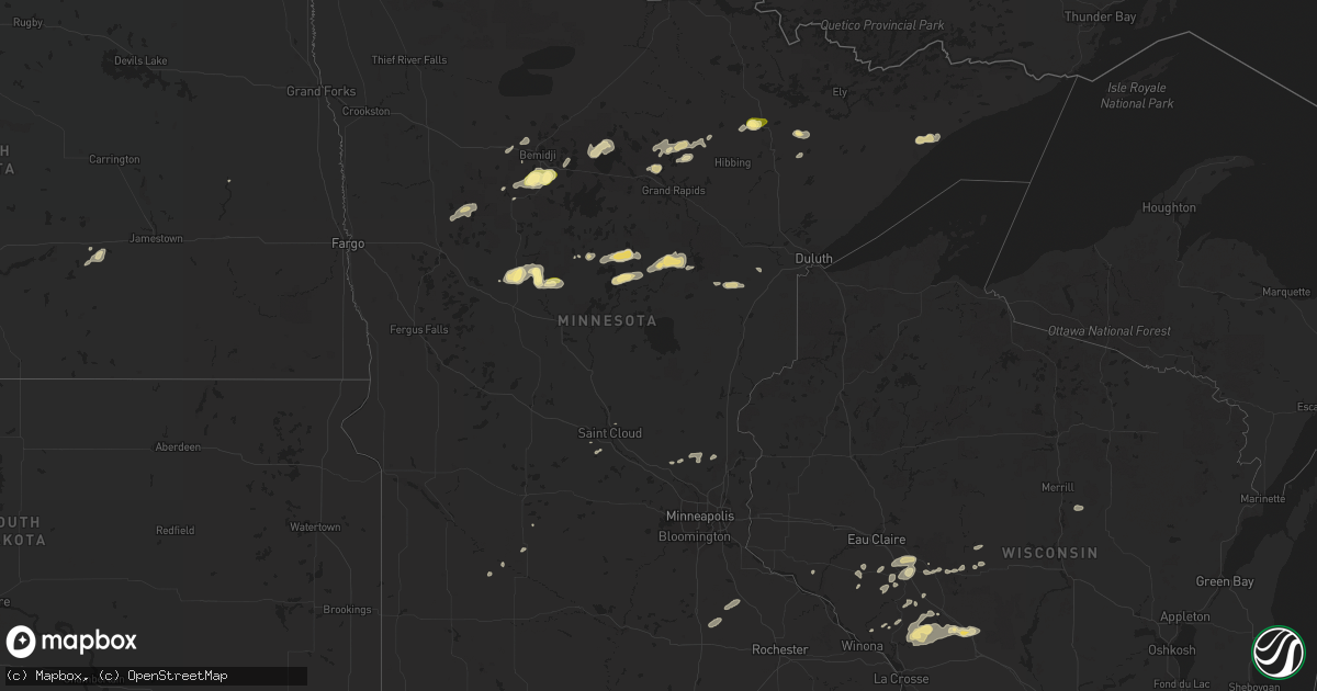
Hail Map in Minnesota on September 6, 2015
Get this storm
September 6 map
$229
one time, instant access
Download today. No call, no setup
Keep the $229
Bought the map and want the full workflow? Apply the entire $229 to a subscription within 7 days. None of it is wasted.
Every map, not just this one
This buys you this map. Subscription and you get every map we run, in the markets you choose from a few cities to whole states to nationwide. Plus real-time alerts the moment a storm fires.
Contact data
Name, contact info, occupancy, even credit band for addresses in the footprint. You go from where it hit to who to call.
Become the source they trust
Unlimited branding weather history reports on demand. You already have the documented answer ready for the property owner, and you are the one who showed up with it.
Property data and RoofTrace estimates
Pull up any address you have got, its value and the exact code rules for that jurisdiction, straight from One Click Code. Then RoofTrace estimates the squares, pitch, and roof value, priced the way you price.
Storm reports in Minnesota
Minnesota
| Date | Description |
|---|---|
| 09/06/20155:39 PM CDT | 6 inch diameter live poplar tree snapped off at 20 ft. Time radar estimated. |
| 09/06/20155:39 PM CDT | 18 inch diameter oak tree downed and blocking butterfield beach road approximately 0.8 miles north of county highway 1. Time radar estimated. |
| 09/06/20154:08 PM CDT | 4 inch diameter pine tree partially blocking cr 49 at mn 38. |
| 09/06/20153:05 PM CDT | Very heavy rainfall with intermittent large hail reported near highway 71. |
All States Impacted by Hail Map on September 6, 2015
Cities Impacted by Hail Map on September 6, 2015
- Crystal Lake, IA
- Ashland, NE
- Blair, NE
- Arlington, NE
- Kennard, NE
- Fifty Lakes, MN
- Emily, MN
- Outing, MN
- Renwick, IA
- Corwith, IA
- Kanawha, IA
- Britt, IA
- Lu Verne, IA
- Martell, NE
- Carroll, IA
- Auburn, IA
- Wall Lake, IA
- Glidden, IA
- Arcadia, IA
- Lake View, IA
- Breda, IA
- Black River Falls, WI
- Unadilla, NE
- Pleasant Dale, NE
- Syracuse, NE
- Lincoln, NE
- Bennet, NE
- Avoca, NE
- Elmwood, NE
- Denton, NE
- Waverly, NE
- Eagle, NE
- Palmyra, NE
- Walton, NE
- White Castle, LA
- Hallam, NE
- Roca, NE
- Sprague, NE
- Manly, IA
- Mason City, IA
- Springfield, NE
- Halbur, IA
- Westside, IA
- Templeton, IA
- Lake City, IA
- Sac City, IA
- Manning, IA
- Lidderdale, IA
- Union, NE
- Palisade, MN
- Mcgregor, MN
- Angora, MN
- Britt, MN
- Audubon, IA
- Fairchild, WI
- Warrens, WI
- Sparta, WI
- Tomah, WI
- Clarinda, IA
- Sebeka, MN
- Menahga, MN
- Bemidji, MN
- Gilmore City, IA
- Humboldt, IA
- Finland, MN
- Neillsville, WI
- Granton, WI
- Soldier, IA
- Ute, IA
- Crosby, MN
- Crosslake, MN
- Baton Rouge, LA
- Manson, IA
- Pomeroy, IA
- Palmer, IA
- Jolley, IA
- Lytton, IA
- Weeping Water, NE
- Plattsmouth, NE
- Louisville, NE
- Ceresco, NE
- Greenwood, NE
- Ithaca, NE
- Memphis, NE
- Yutan, NE
- Gretna, NE
- Melrose, WI
- Backus, MN
- Saint Martinville, LA
- Grosse Tete, LA
- Hixton, WI
- Benton, IA
- Diagonal, IA
- Mount Ayr, IA
- Bagley, IA
- Bancroft, IA
- Tamarack, MN
- Cromwell, MN
- Kettle River, MN
- Strum, WI
- Independence, WI
- Merrifield, MN
- Aitkin, MN
- Rutland, IA
- Echo, MN
- Belview, MN
- Marcell, MN
- Bovey, MN
- Renville, MN
- Redwood Falls, MN
- Percival, IA
- Thurman, IA
- Laporte, MN
- Wausau, WI
- Thornton, IA
- Garner, IA
- Klemme, IA
- Clear Lake, IA
- Goodell, IA
- Swaledale, IA
- Rockwell, IA
- Jena, LA
- Hickman, NE
- Alvo, NE
- Crete, NE
- Murdock, NE
- Lohrville, IA
- Osseo, WI
- Augusta, WI
- Panama, NE
- Firth, NE
- Adams, NE
- Deer River, MN
- Pine River, MN
- Greenwell Springs, LA
- Clinton, LA
- Zachary, LA
- Pride, LA
- Denham Springs, LA
- Baker, LA
- Ponsford, MN
- Waubun, MN
- Ogema, MN
- Chili, WI
- Papillion, NE
- Bellevue, NE
- Humbird, WI
- Guthrie Center, IA
- Bayard, IA
- Gray, IA
- Irwin, IA
- Dedham, IA
- Coon Rapids, IA
- Manilla, IA
- Blair, WI
- Ettrick, WI
- Verndale, MN
- Staples, MN
- Woodville, MS
- Dorchester, NE
- Addis, LA
- Brusly, LA
- Plaquemine, LA
- Port Allen, LA
- Grafton, IA
- Osage, IA
- Mindoro, WI
- Taylor, WI
- Bode, IA
- Greensburg, LA
- Eleva, WI
- Mondovi, WI
- Nerstrand, MN
- Dennison, MN
- Kenyon, MN
- Cannon Falls, MN
- Mondamin, IA
- Little Sioux, IA
- Tekamah, NE
- Wesley, IA
- Amite, LA
- Arcadia, WI
- Loyal, WI
- Ottosen, IA
- Murray, IA
- Truro, IA
- Saint Cloud, MN
- Sauk Rapids, MN
- Meservey, IA
- Woden, IA
- Livermore, IA
- Forest City, IA
- Park Rapids, MN
- Medina, ND
- Jonesville, LA
- Kirkman, IA
- Scranton, IA
- Yale, IA
- Decorah, IA
- Harlan, IA
- Plainfield, IA
- Waverly, IA
- Medford, MN
- Faribault, MN
- Bethel, MN
- Stacy, MN
- Gulfport, MS
- Portsmouth, IA
- Earling, IA
- Defiance, IA
- Panama, IA
- Hannaford, ND
- Streeter, ND
- Tabor, IA
- Deloit, IA
- Aspinwall, IA
- Vail, IA
- Denison, IA
- Dow City, IA
- Moorhead, IA
- Essex, IA
- Jefferson, IA
- Grand Junction, IA
- Rippey, IA
- Biloxi, MS
- Aurora, MN
- Grand Rapids, MN
- Davey, NE
- Ventura, IA
- Clearfield, IA
- Blockton, IA
- Bedford, IA
- Embarrass, MN
- Enterprise, AL
- New Brockton, AL
- New Market, IA
- Paton, IA
- Kimball, MN
- Isanti, MN
- Saint Francis, MN
- Cedar, MN
- Sawyer, MN
- Lake Arthur, LA
- Vega, TX
- Nashwauk, MN
- Elk River, MN
- Western, NE
- Rockford, IA
- Charles City, IA
- Channing, TX
- Nebraska City, NE
- Buna, TX
- Call, TX
- Fremont, NE
- Valley, NE
- Rio Rico, AZ
- Bay Saint Louis, MS
- Nora Springs, IA
- Hamburg, IA
- Arkansaw, WI
- Pepin, WI
- Osceola, IA
- Dunbar, NE
- Douglas, NE
- South Bend, NE
- Milford, NE
- Wilber, NE
- Malcolm, NE
- Otoe, NE
- Burr, NE
- Pisgah, IA
- Herman, NE
- Havelock, IA
- Linden, IA
- Solway, MN
- Shevlin, MN
- Donaldsonville, LA
- Galesville, WI
- Shelby, IA
- Chisholm, MN
- Olivia, MN
- Talmage, NE
- Cass Lake, MN
- Walker, MN
- Shenandoah, IA
- Kentwood, LA
- Sumner, IA
- Tripoli, IA
- Lake Lillian, MN
- Anoka, MN
- Aniwa, WI
- Murray, NE
- Nehawka, NE


