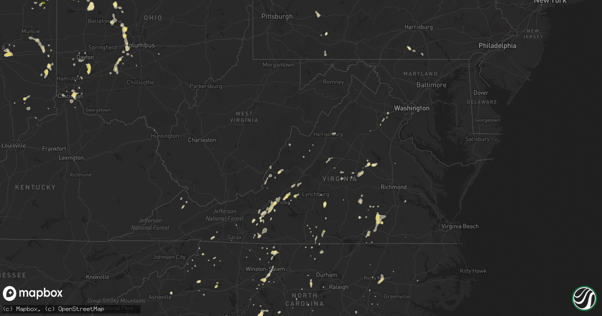
Hail Map in Virginia on September 4, 2015
Get this storm
September 4 map
$229
one time, instant access
Download today. No call, no setup
Keep the $229
Bought the map and want the full workflow? Apply the entire $229 to a subscription within 7 days. None of it is wasted.
Every map, not just this one
This buys you this map. Subscription and you get every map we run, in the markets you choose from a few cities to whole states to nationwide. Plus real-time alerts the moment a storm fires.
Contact data
Name, contact info, occupancy, even credit band for addresses in the footprint. You go from where it hit to who to call.
Become the source they trust
Unlimited branding weather history reports on demand. You already have the documented answer ready for the property owner, and you are the one who showed up with it.
Property data and RoofTrace estimates
Pull up any address you have got, its value and the exact code rules for that jurisdiction, straight from One Click Code. Then RoofTrace estimates the squares, pitch, and roof value, priced the way you price.
Storm reports in Virginia
Virginia
| Date | Description |
|---|---|
| 09/04/20155:55 PM CDT | Trees down on woolwine hwy |
| 09/04/20155:09 PM CDT | Trained spotter reports hail up to an inch in diameter that fell along bobcat trail road in floyd county... Va. |
| 09/04/20154:35 PM CDT | Power lines down on salem ave |
| 09/04/20154:30 PM CDT | Quarter size hail on thomason lane |
| 09/04/20154:25 PM CDT | Tree down on a house. Ramada road in vinton. |
| 09/04/20154:21 PM CDT | Quarter size hail on electric road |
| 09/04/20154:20 PM CDT | Hail an inch and a half deep. |
| 09/04/20154:18 PM CDT | A local report indicates 1.00 inch wind near 6 SW ROANOKE |
| 09/04/20154:10 PM CDT | Quarter size hail on brandon road |
| 09/04/20154:07 PM CDT | Public reports hail of quarter sized along mud lick road near roanoke... Va. |
| 09/04/20154:05 PM CDT | A local report indicates 1.00 inch wind near 3 W BEDFORD |
| 09/04/20154:00 PM CDT | Hail of nickel to quarter size on busted rock road |
| 09/04/20153:42 PM CDT | Trees down along interstate 85 southbound |
| 09/04/20153:40 PM CDT | Trees down along christanna highway |
| 09/04/20153:25 PM CDT | One tree down in south boston. |
| 09/04/20153:20 PM CDT | Hail from nickel to quarter size on mountain rd |
| 09/04/20153:11 PM CDT | A tree was reported down on woodland church road near cherry hill road. |
| 09/04/20153:06 PM CDT | A tree was reported down on eggbornsville road near chesterfield lane. |
| 09/04/20152:28 PM CDT | Several trees were down along dumfries road. |
| 09/04/20152:20 PM CDT | Hail ranged from nickel to quarter size on manley branch road |
| 09/04/20152:18 PM CDT | Several trees and tree limbs snapped on vint hill road near aqua view court. |
| 09/04/20152:15 PM CDT | Dolly ann drive |
| 09/04/20151:55 PM CDT | Several trees were down along old dumfries road. |
| 09/04/20151:50 PM CDT | A local report indicates 1.00 inch wind near 3 SW CRAIGSVILLE |
All States Impacted by Hail Map on September 4, 2015
Cities Impacted by Hail Map on September 4, 2015
- Tionesta, PA
- Orrum, NC
- Homestead, MT
- Waynesboro, GA
- Millen, GA
- Lexington, NC
- Alzada, MT
- Floyd, VA
- Willis, VA
- Brockton, MT
- North Judson, IN
- Warfield, VA
- McKenney, VA
- Liberty, IN
- Crawfordsville, IN
- Waveland, IN
- Louisa, VA
- Mount Sterling, OH
- Connersville, IN
- Brookville, IN
- Little Falls, MN
- Union, SC
- Stoystown, PA
- Hooversville, PA
- Linwood, NC
- Iron Gate, VA
- Meadows Of Dan, VA
- Convoy, OH
- Scott, OH
- Van Wert, OH
- Sligo, PA
- Stanley, ND
- Flintstone, MD
- Boyes, MT
- Jasper, GA
- Chebanse, IL
- Saint Anne, IL
- Pierceton, IN
- Warsaw, IN
- Andrews, IN
- Larwill, IN
- Markle, IN
- Zanesville, IN
- Yoder, IN
- Ossian, IN
- Roanoke, IN
- South Whitley, IN
- Claypool, IN
- Fort Wayne, IN
- Columbia City, IN
- Huntington, IN
- Weston, WY
- Vansant, VA
- Vinton, VA
- Roanoke, VA
- Blue Ridge, VA
- Christiansburg, VA
- Riner, VA
- Greenfield, IN
- Albertson, NC
- Onarga, IL
- Gilman, IL
- Danforth, IL
- Troutdale, VA
- Saluda, SC
- Carrington, ND
- Brodnax, VA
- White Plains, VA
- West Jefferson, OH
- Kingman, IN
- Veedersburg, IN
- Wingate, IN
- Mellott, IN
- Hillsboro, IN
- Greens Fork, IN
- Cambridge City, IN
- Siler City, NC
- Thomasboro, IL
- Champaign, IL
- Dewey, IL
- Okahumpka, FL
- Groveland, FL
- Leesburg, FL
- Stuart, VA
- Woolwine, VA
- Buchanan, VA
- Leesburg, IN
- Blackduck, MN
- Tidioute, PA
- Waynetown, IN
- Alamo, IN
- Catlin, IL
- Tilton, IL
- Westville, IL
- Danville, IL
- Park River, ND
- Concord, VA
- Appomattox, VA
- Edmore, ND
- La Crosse, VA
- West Chester, OH
- Windsor, NC
- Napoleon, ND
- Stanfield, NC
- Albemarle, NC
- Locust, NC
- Oakboro, NC
- Mooreland, IN
- Losantville, IN
- Fair Bluff, NC
- Dayton, KY
- Fort Thomas, KY
- Cincinnati, OH
- Bellevue, KY
- Newport, KY
- Casselberry, FL
- Winter Park, FL
- Francesville, IN
- Walnut Cove, NC
- Wildwood, FL
- The Villages, FL
- Metamora, IN
- Laurel, IN
- Walker, MN
- Cass Lake, MN
- Madison, NC
- Ladoga, IN
- Four Oaks, NC
- Milford, OH
- Cushing, MN
- Lawton, ND
- Scotland Neck, NC
- Hobgood, NC
- Danbury, NC
- Walhalla, ND
- Pilot, VA
- Ludlow, PA
- Taylorsville, NC
- Granite Falls, NC
- Hickory, NC
- Arcola, IL
- Hoople, ND
- Edinburg, ND
- Valdosta, GA
- Winston Salem, NC
- Alva, WY
- Venedocia, OH
- Delphos, OH
- Spencerville, OH
- Fork Union, VA
- Columbia, VA
- Newberry, SC
- Solway, MN
- Morganton, NC
- Lenoir, NC
- Crary, ND
- Devils Lake, ND
- Lynchburg, SC
- Corsica, PA
- Montezuma, IN
- Raeford, NC
- Winamac, IN
- Kewanna, IN
- Rochester, IN
- Twelve Mile, IN
- Royal Center, IN
- Lucerne, IN
- Star City, IN
- Mandaree, ND
- Killdeer, ND
- Darlington, IN
- Shawsville, VA
- Check, VA
- Donnybrook, ND
- Wilson, NC
- Dayton, OH
- Morocco, IN
- La Rue, OH
- Mount Victory, OH
- New Castle, IN
- Economy, IN
- Hagerstown, IN
- Washington Court House, OH
- Gap Mills, WV
- Paint Bank, VA
- Covington, VA
- West Mansfield, OH
- East Liberty, OH
- Zanesfield, OH
- Lester, WV
- Marshville, NC
- Monroe, NC
- Pine Hall, NC
- Mayesville, SC
- Delphi, IN
- Monticello, IN
- Brookston, IN
- Mouth Of Wilson, VA
- Sheyenne, ND
- New Rockford, ND
- Hibbing, MN
- Chrisman, IL
- Mahomet, IL
- Marysville, OH
- Austinville, VA
- Beech Grove, IN
- Indianapolis, IN
- Plentywood, MT
- Antelope, MT
- Pinetops, NC
- Rocky Mount, NC
- Sutherlin, VA
- Tappen, ND
- New Oxford, PA
- Chapel Hill, NC
- Grove City, OH
- Galloway, OH
- London, OH
- Mccordsville, IN
- New Palestine, IN
- Mansfield, IL
- Ottawa, OH
- Columbus Grove, OH
- Pandora, OH
- Kenmare, ND
- Dahlen, ND
- Roachdale, IN
- Bainbridge, IN
- Crystal, ND
- Fordville, ND
- Lankin, ND
- Pierz, MN
- Williamsburg, IN
- Saint Cloud, FL
- Oregonia, OH
- Spring Valley, OH
- Bellbrook, OH
- Waynesville, OH
- Thaxton, VA
- Bedford, VA
- Clover, SC
- Gastonia, NC
- Marienville, PA
- Black Mountain, NC
- Scottsville, VA
- Esmont, VA
- Frametown, WV
- Gassaway, WV
- Sardis, GA
- Motley, MN
- Banner Elk, NC
- Boone, NC
- Pittsboro, NC
- Donovan, IL
- Lake Village, IN
- Brook, IN
- Beaverville, IL
- Langdon, ND
- Kite, GA
- Kenton, OH
- Peotone, IL
- Wilmington, IL
- Manteno, IL
- Clifton, IL
- Ashkum, IL
- Buffalo, SD
- Lima, OH
- Uniopolis, OH
- Waynesfield, OH
- Wapakoneta, OH
- Victoria, VA
- Blairsville, PA
- New Florence, PA
- Armagh, PA
- Roseglen, ND
- Dolphin, VA
- Lawrenceville, VA
- Dinwiddie, VA
- Wilsons, VA
- Dewitt, VA
- Rawlings, VA
- Chatham, VA
- Froid, MT
- Reserve, MT
- Culbertson, MT
- Muncie, IN
- Springport, IN
- Keeling, VA
- Lebanon, IN
- Jamestown, IN
- Greenville, SC
- Laporte, MN
- Akron, IN
- Silver Lake, IN
- Tippecanoe, IN
- Mentone, IN
- Millers Creek, NC
- Hoopeston, IL
- Cissna Park, IL
- Rankin, IL
- Rossville, IL
- French Creek, WV
- Copper Hill, VA
- Callaway, VA
- Salem, VA
- Bent Mountain, VA
- Greer, SC
- Woodburn, IN
- Plain City, OH
- Coatesville, IN
- San Pierre, IN
- Wheatfield, IN
- Medaryville, IN
- Rembert, SC
- Mullins, SC
- Woodville, OH
- Elmore, OH
- Ford, VA
- Fremont, OH
- Gibsonburg, OH
- Lindsey, OH
- Helena, OH
- Parker, PA
- Sanford, NC
- Georgetown, IL
- Natural Bridge Station, VA
- Homer City, PA
- Monroe, OH
- Osakis, MN
- Keezletown, VA
- Concord, NC
- Windermere, FL
- Orlando, FL
- Big Falls, MN
- Midville, GA
- Providence, NC
- Yanceyville, NC
- Blanch, NC
- Longville, MN
- Lebanon, OH
- Creston, NC
- Mountain City, TN
- Winter Garden, FL
- Bumpass, VA
- Mineral, VA
- Kankakee, IL
- Lake View, SC
- Fairmont, NC
- Marshall, IN
- Bloomingdale, IN
- Boones Mill, VA
- Lake Panasoffkee, FL
- Deer River, MN
- Willard, NC
- Fort Lauderdale, FL
- Adams, ND
- Kinards, SC
- Joanna, SC
- Clinton, SC
- Stuart, FL
- Indiantown, FL
- Fair Oaks, IN
- Cohasset, MN
- Grand Rapids, MN
- West Lafayette, IN
- Milton, KY
- Glen Rock, PA
- Glenville, PA
- Spring Grove, PA
- Seven Valleys, PA
- Park Rapids, MN
- New Bern, NC
- Ferguson, NC
- Purlear, NC
- Fleetwood, NC
- Warwick, ND
- Tolna, ND
- Bluffton, IN
- Rantoul, IL
- Ekalaka, MT
- Capitol, MT
- Hammond, MT
- Glen Daniel, WV
- Slab Fork, WV
- Elm City, NC
- Battleboro, NC
- Tarboro, NC
- Swiss, WV
- Graham, NC
- Haw River, NC
- Walkertown, NC
- Liberty Center, IN
- Poneto, IN
- Knox, PA
- Troy, NC
- Effingham, SC
- Timmonsville, SC
- Indianola, IL
- Brookneal, VA
- Spout Spring, VA
- Gladys, VA
- Danville, IN
- Brookville, PA
- Strattanville, PA
- Butlerville, IN
- North Vernon, IN
- Howardsville, VA
- Buckingham, VA
- Thawville, IL
- Palermo, ND
- Pendleton, IN
- Mount Gilead, NC
- Downs, IL
- Trenton, FL
- Bell, FL
- Newland, NC
- Apex, NC
- Donalds, SC
- Abbeville, SC
- Bena, MN
- Bismarck, IL
- Alvin, IL
- Mableton, GA
- Atlanta, GA
- Austell, GA
- Bremo Bluff, VA
- Oakwood, VA
- Mebane, NC
- Wolcott, IN
- Blackstone, VA
- Hillsdale, IN
- Dana, IN
- Montvale, VA
- Todd, NC
- Lucama, NC
- Kenly, NC
- Nokesville, VA
- Bristow, VA
- New Town, ND
- Remington, IN
- Churchville, VA
- Claudville, VA
- Bemidji, MN
- Hackensack, MN
- Payne, OH
- Monroeville, IN
- Faison, NC
- Mount Olive, NC
- Newton Grove, NC
- Osnabrock, ND
- Alsen, ND
- Ruther Glen, VA
- Prospect Hill, NC
- Hammond, IL
- South Solon, OH
- Bloomingburg, OH
- Monterey, VA
- Max, MN
- Talmoon, MN
- Effie, MN
- Spring Lake, MN
- Bigfork, MN
- Wirt, MN
- Bracey, VA
- Woodworth, ND
- Rensselaer, IN
- Roxboro, NC
- Lowell, IN
- Jetersville, VA
- Burkeville, VA
- Crewe, VA
- King, NC
- South Boston, VA
- Brocket, ND
- Meyersdale, PA
- Sheffield, PA
- Lovington, IL
- North Manchester, IN
- Charleston, SC
- New Lebanon, OH
- Miamisburg, OH
- Germantown, OH
- Saulsville, WV
- Maben, WV
- Glen Rogers, WV
- Ravencliff, WV
- Elk Park, NC
- Battle Ground, IN
- Camp Crook, SD
- Mountville, SC
- Swoope, VA
- Cavalier, ND
- Hensel, ND
- Sandy Ridge, NC
- Le Roy, IL
- Halifax, VA
- Uniondale, IN
- Holton, IN
- Akeley, MN
- Browerville, MN
- Due West, SC
- China Grove, NC
- Greenwood, VA
- Grafton, WV
- Amelia Court House, VA
- Bennett, NC
- Green Springs, OH
- Oak Harbor, OH
- Clyde, OH
- Alton, VA
- Urbana, IN
- Lagro, IN
- Duck, WV
- Catlett, VA
- Hillsville, VA
- Knox, IN
- Silver Grove, KY
- Wabash, IN
- Roann, IN
- Westfield, NC
- Kane, PA
- Bishopville, SC
- Eagle Springs, NC
- Montpelier, IN
- Warsaw, NC
- Clinton, NC
- Turkey, NC
- Thomasville, NC
- Gifford, IL
- Kents Store, VA
- Northome, MN
- Lakota, ND
- Milford, IL
- White Sulphur Springs, WV
- Moneta, VA
- Semora, NC
- Rice, VA
- Dupont, IN
- Afton, VA
- Keystone, IN
- Brockport, PA
- Kersey, PA
- Ridgway, PA
- Manassas, VA
- Catharpin, VA
- Gainesville, VA
- Goodview, VA
- Sumter, SC
- Alexandria, KY
- Miami, FL
- Herscher, IL
- Martinton, IL
- Gold Hill, NC
- Mount Pleasant, NC
- Medina, ND
- Midland, VA
- Sykeston, ND
- Logansport, IN
- Kernersville, NC
- Sabina, OH
- Old Town, FL
- Aladdin, WY
- Hulett, WY
- Covington, IN
- Attica, IN
- Ft Mitchell, KY
- Latonia, KY
- Lake Wales, FL
- Littlefork, MN
- New Castle, VA
- Manhattan, IL
- Channahon, IL
- Richmond, IN
- Pikeville, NC
- Goldsboro, NC
- Ridgeway, OH
- Raymond, OH
- New Creek, WV
- Middle Point, OH
- Scarbro, WV
- Milton, NC
- Vernon Hill, VA
- Java, VA
- Mocksville, NC
- Menahga, MN
- Nevis, MN
- Dobson, NC
- Fort Ripley, MN
- Red Springs, NC
- Talking Rock, GA
- Goodland, IN
- Pekin, ND
- Jupiter, FL
- Jeffersonville, OH
- Whitakers, NC
- Burnettsville, IN
- Monroe, IN
- Decatur, IN
- Loveland, OH
- Randall, MN
- Circleville, OH
- Astatula, FL
- Metcalf, IL
- Nashwauk, MN
- Bovey, MN
- Mokena, IL
- Milton, ND
- Geneva, IN
- Florence, SC
- Advance, IN
- Hanover, PA
- Abbottstown, PA
- Thurmond, WV
- Oak Hill, WV
- Willard, OH
- Sugar Grove, NC
- Whitmire, SC
- Lamar, SC
- Momence, IL
- New Ross, IN
- Kenbridge, VA
- La Porte, IN
- Clinton, IN
- Nathalie, VA
- Westpoint, IN
- Dillon, SC
- Bennington, IN
- Ridge Farm, IL
- Marion, SC
- Stantonsburg, NC
- Fortville, IN
- Hoagland, IN
- Farmer City, IL
- Hopewell, VA
- Dalzell, SC
- West Jefferson, NC
- Culver, IN
- Halliday, ND
- Beulah, ND
- Bourbonnais, IL
- Thorntown, IN
- Colfax, IN
- Centerville, IN
- Capron, VA
- Grundy, VA
- Frankfort, IN
- New Bethlehem, PA
- Beckley, WV
- Sumterville, FL
- Orient, OH
- Farmville, VA
- Prospect, VA
- Pleasantville, OH
- Baltimore, OH
- Richwood, OH
- Snow Hill, NC
- Gettysburg, PA
- Clifton Forge, VA
- Yeoman, IN
- Sheldon, IL
- Craigville, IN
- Laurel Fork, VA
- Wellington, IL
- Pompano Beach, FL
- Lambert, MT
- Ironton, OH
- Arvonia, VA
- Cameron, NC
- Linville, NC
- Palm Beach Gardens, FL
- Palmyra, VA
- Farmersville, OH
- Hebron, KY
- Ararat, NC
- Campbellsburg, KY
- Macy, IN
- Denver, IN
- Goshen, VA
- Craigsville, VA
- Culpeper, VA
- Clayton, OH
- Galax, VA
- Faber, VA
- Ostrander, OH
- Pisek, ND
- Petersburg, ND
- Mayodan, NC
- Westby, MT


