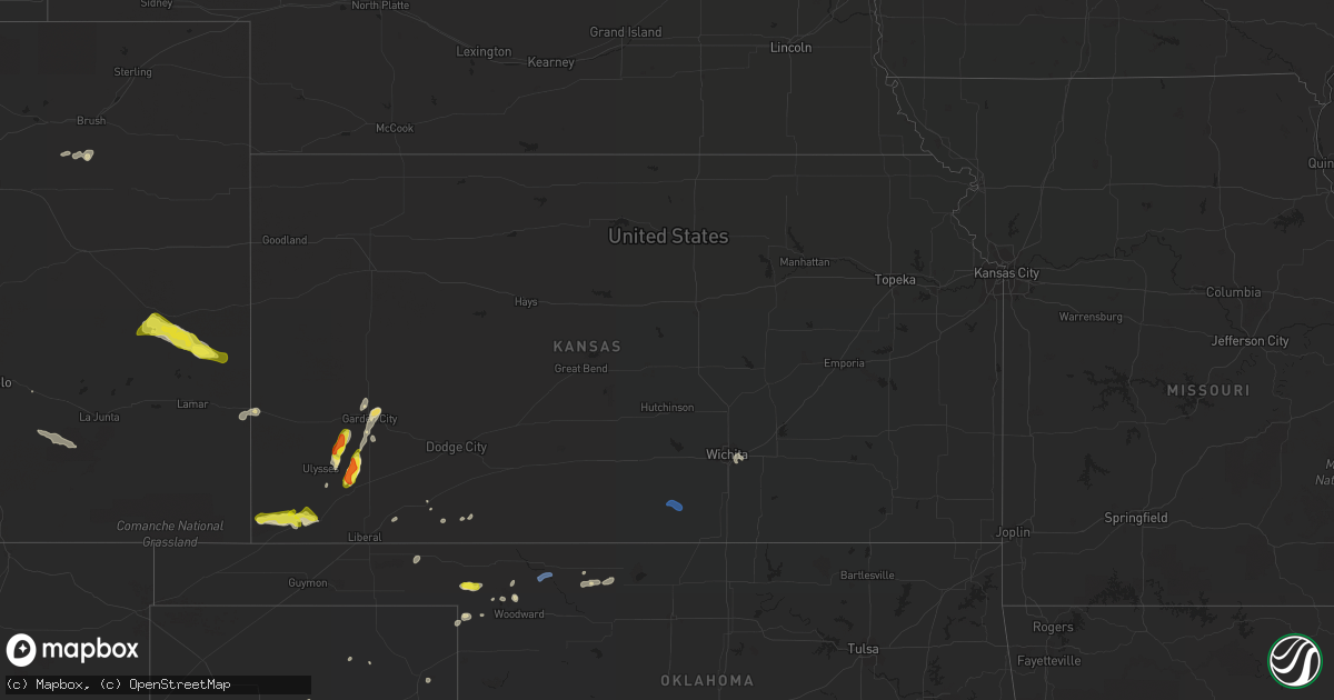
Hail Map in Kansas on September 3, 2021
Get this storm
September 3 map
$229
one time, instant access
Download today. No call, no setup
Keep the $229
Bought the map and want the full workflow? Apply the entire $229 to a subscription within 7 days. None of it is wasted.
Every map, not just this one
This buys you this map. Subscription and you get every map we run, in the markets you choose from a few cities to whole states to nationwide. Plus real-time alerts the moment a storm fires.
Contact data
Name, contact info, occupancy, even credit band for addresses in the footprint. You go from where it hit to who to call.
Become the source they trust
Unlimited branding weather history reports on demand. You already have the documented answer ready for the property owner, and you are the one who showed up with it.
Property data and RoofTrace estimates
Pull up any address you have got, its value and the exact code rules for that jurisdiction, straight from One Click Code. Then RoofTrace estimates the squares, pitch, and roof value, priced the way you price.
Storm reports in Kansas
Kansas
| Date | Description |
|---|---|
| 09/03/20216:13 PM CDT | A local report indicates 1.75 inch wind near 13 NNE RYUS |
| 09/03/20215:50 PM CDT | A local report indicates 1.00 inch wind near 4 NNE ROLLA |
| 09/03/20215:48 PM CDT | A local report indicates 1.75 inch wind near 5 NNE RYUS |
| 09/03/20214:50 AM CDT | At 950 PM MDT, severe thunderstorms were located along a line extending from near Brandon to near McClave, moving southeast at 20 mph. HAZARD...60 mph wind gusts and quarter size hail. SOURCE...Radar indicated. IMPACT...Hail damage to vehicles is expected. Expect wind damage to roofs, siding, and trees. Severe thunderstorms will be near... Chivington around 955 PM MDT. Brandon around 1005 PM MDT.Other locations in the path of these severe thunderstorms includeWiley, Sheridan Lake and Lamar. |
| 09/03/20212:44 AM CDT | At 743 PM CDT, severe thunderstorms were located along a line extending from 5 miles northeast of Harper to 8 miles northwest of Renfrow, moving east at 25 mph. HAZARD...60 mph wind gusts and penny size hail. SOURCE...Radar indicated. IMPACT...Expect damage to roofs, siding, and trees. Locations impacted include... Anthony, Harper, Conway Springs, Caldwell, Argonia, South Haven, Mayfield, Milan, Hunnewell, Bluff City, Danville, Freeport, Perth and Runnymede. |
| 09/03/20211:33 AM CDT | At 633 PM CDT, a severe thunderstorm was located 11 miles north of Hickok, moving north at 20 mph. HAZARD...Ping pong ball size hail and 60 mph wind gusts. SOURCE...Radar indicated. IMPACT...People and animals outdoors will be injured. Expect hail damage to roofs, siding, windows, and vehicles. Expect wind damage to roofs, siding, and trees. This severe thunderstorm will remain over mainly rural areas of southeastern Kearny, southwestern Finney and northeastern Grant Counties. |
| 09/03/20211:09 AM CDT | At 609 PM CDT, a severe thunderstorm was located 11 miles northeast of Ryus, moving northeast at 20 mph. HAZARD...60 mph wind gusts and quarter size hail. SOURCE...Radar indicated. IMPACT...Hail damage to vehicles is expected. Expect wind damage to roofs, siding, and trees. Locations impacted include... Plymell. |
| 09/03/202112:51 AM CDT | At 551 PM CDT, a severe thunderstorm was located near Rolla, moving northeast at 20 mph. HAZARD...60 mph wind gusts and quarter size hail. SOURCE...Radar indicated. IMPACT...Hail damage to vehicles is expected. Expect wind damage to roofs, siding, and trees. This severe thunderstorm will be near... Feterita around 605 PM CDT.Other locations in the path of this severe thunderstorm includeHugoton. |
| 09/03/202112:44 AM CDT | At 544 PM CDT, a severe thunderstorm was located near Ryus, moving northeast at 15 mph. HAZARD...60 mph wind gusts and quarter size hail. SOURCE...Radar indicated. IMPACT...Hail damage to vehicles is expected. Expect wind damage to roofs, siding, and trees. This severe thunderstorm will remain over mainly rural areas of east central Grant and central Haskell Counties. |
| 09/03/202112:20 AM CDT | Report from kdot mesonet site. |
| 09/03/202112:13 AM CDT | At 513 PM CDT, a severe thunderstorm was located near Feterita, moving northeast at 10 mph. HAZARD...60 mph wind gusts and quarter size hail. SOURCE...Radar indicated. IMPACT...Hail damage to vehicles is expected. Expect wind damage to roofs, siding, and trees. Locations impacted include... Hugoton. |
| 09/03/202112:09 AM CDT | At 508 PM CDT, a severe thunderstorm was located 9 miles southwest of Richfield, moving northeast at 15 mph. HAZARD...60 mph wind gusts and quarter size hail. SOURCE...Radar indicated. IMPACT...Hail damage to vehicles is expected. Expect wind damage to roofs, siding, and trees. Locations impacted include... Richfield. |
All States Impacted by Hail Map on September 3, 2021
Cities Impacted by Hail Map on September 3, 2021
- Meade, KS
- Fowler, KS
- Satanta, KS
- Woodrow, CO
- Kit Carson, CO
- Eads, CO
- Sheridan Lake, CO
- Coolidge, KS
- Holly, CO
- Syracuse, KS
- Ulysses, KS
- Lance Creek, WY
- Laverne, OK
- Lusk, WY
- Littleton, CO
- Morrison, CO
- Woodward, OK
- Fort Supply, OK
- Duchesne, UT
- Edgemont, SD
- Fritch, TX
- Masterson, TX
- Lakin, KS
- Parker, CO
- Lone Tree, CO
- Englewood, CO
- Fowler, CO
- Plains, KS
- Kismet, KS
- Vernal, UT
- Hartville, WY
- Glendo, WY
- Vega, TX
- Shattuck, OK
- Cheyenne, WY
- Hillsdale, WY
- Burns, WY
- Garden City, KS
- Dacoma, OK
- Alva, OK
- Rolla, KS
- Richfield, KS
- Oral, SD
- Hot Springs, SD
- Hugoton, KS
- Cherokee, OK
- Wichita, KS
- Mcconnell Afb, KS
- Elkhart, KS
- Fort Morgan, CO
- Amarillo, TX
- Miami, TX
- Spearman, TX
- Perryton, TX
- Buffalo, OK
- Fargo, OK
- Smithwick, SD
- Canadian, TX
- Holcomb, KS
- Waynoka, OK
- Boone, CO
- Englewood, KS
- Forgan, OK
- Wheatland, WY
- Wildorado, TX
- Ashland, KS
- Mooreland, OK
- Freedom, OK
- Harper, KS
- Danville, KS
- Argonia, KS
- Ryegate, MT
- Shawmut, MT
- Judith Gap, MT


