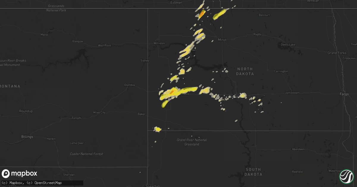
Hail Map on September 3, 2018
Get this storm
September 3 map
$229
one time, instant access
Download today. No call, no setup
Keep the $229
Bought the map and want the full workflow? Apply the entire $229 to a subscription within 7 days. None of it is wasted.
Every map, not just this one
This buys you this map. Subscription and you get every map we run, in the markets you choose from a few cities to whole states to nationwide. Plus real-time alerts the moment a storm fires.
Contact data
Name, contact info, occupancy, even credit band for addresses in the footprint. You go from where it hit to who to call.
Become the source they trust
Unlimited branding weather history reports on demand. You already have the documented answer ready for the property owner, and you are the one who showed up with it.
Property data and RoofTrace estimates
Pull up any address you have got, its value and the exact code rules for that jurisdiction, straight from One Click Code. Then RoofTrace estimates the squares, pitch, and roof value, priced the way you price.
States Impacted by Hail Map on September 3, 2018
Storm reports
New York
| Date | Description |
|---|---|
| 09/03/20184:15 PM CDT | Trees down on wires... Wires down. Time estimated from radar |
| 09/03/20184:02 PM CDT | Tree down on mobile home |
| 09/03/20182:17 PM CDT | Trees and wires down in the town of hartland |
| 09/03/20182:01 PM CDT | Trees and wires down |
| 09/03/20181:52 PM CDT | Tree and wire down |
| 09/03/20181:46 PM CDT | Trees and wires down |
| 09/03/20181:38 PM CDT | Tree down on house in lewiston |
| 09/03/20181:15 PM CDT | Trees and wires down on bear creek road in woodgate area. |
| 09/02/201811:24 PM CDT | At 423 PM EDT, a severe thunderstorm was located near Franklinville, or 21 miles north of Olean, moving east at 15 mph. HAZARD...60 mph wind gusts and quarter size hail. SOURCE...Radar indicated. IMPACT...Minor damage to vehicles is possible. Expect wind damage to roofs, siding, and trees. Locations impacted include... Franklinville, Rushford, Houghton, Caneadea, Lyndon, Black Creek, Farmersville Station, Hardy Corners, Lime Lake, Rushford Lake. |
| 09/02/201810:12 PM CDT | At 311 PM EDT, a severe thunderstorm was located near Middleport, or 7 miles west of Medina, moving east at 35 mph. HAZARD...60 mph wind gusts. SOURCE...Radar indicated. IMPACT...Expect damage to roofs, siding, and trees. Locations impacted include... Brockport, Medina, Albion, Hamlin Beach State Park, Byron, Churchville, Middleport and Oakfield. |
| 09/02/20189:55 PM CDT | At 255 PM EDT, a severe thunderstorm was located near Cato, or 10 miles south of Fair Haven Beach State Park, moving southeast at 25 mph. HAZARD...60 mph wind gusts and quarter size hail. SOURCE...Radar indicated. IMPACT...Minor damage to vehicles is possible. Expect wind damage to roofs, siding, and trees. Locations impacted include... Cato, Phoenix, Ira, Conquest, Meridian and South Hannibal. |
| 09/02/20189:52 PM CDT | At 251 PM EDT, a severe thunderstorm was located near Sanborn, or near North Tonawanda, moving east at 30 mph. HAZARD...60 mph wind gusts. SOURCE...Radar indicated. IMPACT...Expect damage to roofs, siding, and trees. Locations impacted include... Cheektowaga, North Tonawanda, Clarence, Amherst, Tonawanda, Williamsville, Grand Island and Pendleton.This includes Interstate 90 near exit 49. |
| 09/02/20189:34 PM CDT | At 234 PM EDT, a severe thunderstorm was located over Lewiston, moving east at 35 mph. HAZARD...70 mph wind gusts and penny size hail. SOURCE...Radar indicated. IMPACT...Expect considerable tree damage. Damage is likely to mobile homes, roofs, and outbuildings. Locations impacted include... Niagara Falls, Lockport, Newfane, Lewiston, Youngstown, Middleport, Fort Niagara State Park and Sanborn. |
| 09/02/20189:04 PM CDT | At 204 PM EDT, a severe thunderstorm was located near Fair Haven Beach State Park, moving east at 10 mph. HAZARD...60 mph wind gusts and dime size hail. SOURCE...Radar indicated. IMPACT...Expect damage to roofs, siding, and trees. Locations impacted include... Fulton, Central Square, Battle Island State Park, Volney, Palermo, Phoenix, Ira and Hannibal.This includes Interstate 81 near exit 32. |
| 09/02/20188:48 PM CDT | At 147 PM EDT, a severe thunderstorm was located near Boonville, moving east at 35 mph. HAZARD...60 mph wind gusts and penny size hail. SOURCE...Radar indicated. IMPACT...Expect damage to roofs, siding, and trees. Locations impacted include... Highmarket, Port Leyden, Lyons Falls, Constableville, Turin, Mohawk Hill and Talcottville. |
Pennsylvania
| Date | Description |
|---|---|
| 09/03/20186:20 PM CDT | Multiple trees down in muncy creek township. |
| 09/03/20186:05 PM CDT | Several trees downed or snapped along proctor road near plunketts creek. |
| 09/03/20185:42 PM CDT | Tree and wires down at 12078 creek road |
| 09/03/20184:23 PM CDT | One tree down on darrow rd on the southeast side of town. |
| 09/03/20183:50 PM CDT | Large section of one tree down and several other large limbs down. |
| 09/03/20182:00 AM CDT | At 659 PM EDT, severe thunderstorms were located along a line extending from near Loyalsockville to Allenwood, moving southeast at 20 mph. HAZARD...60 mph wind gusts and quarter size hail. SOURCE...Radar indicated. IMPACT...Hail damage to vehicles is expected. Expect wind damage to roofs, siding, and trees. Locations impacted include... Milton, Danville, Montoursville, Muncy, Watsontown, Hughesville, Riverside, Montgomery, New Columbia, Allenwood, Jerseytown, Iola, Lairdsville, Mooresburg, Biggertown, Exchange, Delaware Run, Loyalsockville, Millville and West Milton.For those driving on Interstate 80, this includes areas between theMile Run and Buckhorn exits, specifically from mile markers 202 to226.This includes Interstate 180 from mile markers 1 to 23. |
| 09/02/201811:48 PM CDT | At 448 PM EDT, a severe thunderstorm was located near Albion, or 15 miles east of Conneaut, and is nearly stationary. HAZARD...60 mph wind gusts and quarter size hail. SOURCE...Radar indicated. IMPACT...Minor damage to vehicles is possible. Expect damage to trees and power lines. Locations impacted include... Meadville, Edinboro, Cambridge Springs, Waterford, Albion, Saegertown, Cranesville, Springboro, Platea, Mill Village, Venango and Woodcock. |
| 09/02/201810:23 PM CDT | At 322 PM EDT, a severe thunderstorm was located 7 miles northwest of Grove City, moving southeast at 10 mph. HAZARD...Wind gusts to 60 mph. SOURCE...Radar. IMPACT...Expect damage to trees and power lines, resulting in some power outages. Locations impacted include... Grove City... Mercer... Jackson Center... This includes the following highways... Interstate 79 in Pennsylvania between mile markers 113 and 126. Interstate 80 in Pennsylvania between mile markers 16 and 24. |
Illinois
| Date | Description |
|---|---|
| 09/03/20185:43 PM CDT | Relayed by broadcast media. |
| 09/03/20183:58 PM CDT | Confirmed tornado touchdown from two spotters. Tornado on ground for approximately 1 minute. North of harlem and perryville roads in rock cut state park. Possible tree |
| 09/03/20183:17 PM CDT | Several large trees and tree limbs blown down. One utility pole blown down. Time radar estimated. |
| 09/03/20183:15 PM CDT | Several large trees and tree limbs blown down. One utility pole blown down. Mainly near and west of powis road and near and north of army trail road. Radar indicates th |
| 09/03/20182:28 PM CDT | Two large branches downed in uptown neighborhood on far north side of chicago. Time estimated. |
| 09/03/20182:28 PM CDT | One large tree and one large tree limb blown down near clark and montrose. Time estimated. |
| 09/03/20182:16 PM CDT | Large trees and branches down in garfield park. Large tree blocking road in the southern part of garfield park. Branches scattered across i290 in between pulaski and ka |
| 09/03/20182:14 PM CDT | Ef-0 tornado on west side of chicago tracked from cicero and arthington to just east of garfield park. Track length 1.7 miles with primarily tree damage. One tree into |
| 09/03/20181:56 PM CDT | A local report indicates 60 MPH wind near WESTMONT |
| 09/02/20189:26 PM CDT | At 226 PM CDT, a severe thunderstorm was located over Lakeview, or near Lincoln Park, moving northeast at 30 mph. HAZARD...60 mph wind gusts. SOURCE...Radar indicated. IMPACT...Expect damage to roofs, siding, and trees. Locations impacted include... Chicago, Evanston, Skokie, Lincoln Park, Lakeview, Rogers Park and Lincolnwood.Including the following interstates... I-94 between mile markers 43 and 48. I-294 between mile markers 43 and 48.This includes... Lincoln Park Zoo, Loyola University, NortheasternIllinois University, and Wrigley Field. |
| 09/02/20188:39 PM CDT | At 138 PM CDT, a severe thunderstorm was located over Bolingbrook, moving northeast at 20 mph. HAZARD...60 mph wind gusts. SOURCE...Radar indicated. IMPACT...Expect damage to roofs, siding, and trees. Locations impacted include... Naperville, Bolingbrook, Downers Grove, Romeoville, Westmont, Lisle, Hinsdale, Lemont, Burr Ridge, Oak Brook, Willow Springs, Woodridge, Darien, Palos Hills, Western Springs, Clarendon Hills, Countryside, Indian Head Park, Hodgkins and Goodings Grove.Including the following interstates... I-55 between mile markers 264 and 278. I-88 between mile markers 129 and 133. I-355 between mile markers 8 and 22.This includes... Argonne National Laboratory, BenedictineUniversity, and North Central College. |
Georgia
| Date | Description |
|---|---|
| 09/03/20183:04 PM CDT | Tree down on power line. |
| 09/03/20182:58 PM CDT | Tree down on magnolia drive. |
| 09/03/20182:45 PM CDT | Tree down on cedar springs road. |
| 09/03/201812:30 AM CDT | At 529 PM EDT/429 PM CDT/, Doppler radar indicated a severe thunderstorm capable of producing damaging winds in excess of 60 mph. This storm was located 9 miles east of Marianna, and moving west at 30 mph. Locations impacted include... Marianna, Graceville, Malone, Cottondale, Grand Ridge, Greenwood, Campbellton, Bascom, Jacob City, Kynesville, Blue Spring, Lovedale, Dellwood, Star, Two Egg, Cypress, Cottondale Airport, Jacobs, Browntown and Chipola Terrace. |
| 09/02/201811:59 PM CDT | At 459 PM EDT/359 PM CDT/, a severe thunderstorm was located near Greensboro, or 10 miles northwest of Quincy, moving west at 40 mph. HAZARD...60 mph wind gusts. SOURCE...Radar indicated. IMPACT...Expect damage to roofs, siding, and trees. Locations impacted include... Marianna, Greensboro, Chattahoochee, Sneads, Gretna, Grand Ridge, Altha, Rock Bluff, Ocheesee, Juniper, Douglas City, Selman, Rosedale, Blue Spring, Union City, Henderson Mill, Jinks, Star, Alliance and Mount Pleasant. |
| 09/02/201811:25 PM CDT | At 425 PM EDT, a severe thunderstorm was located near Whigham, or 7 miles southwest of Cairo, moving west at 35 mph. HAZARD...60 mph wind gusts. SOURCE...Radar indicated. IMPACT...Expect damage to roofs, siding, and trees. Locations impacted include... Bainbridge, Havana, Cairo, Tallahassee, Whigham, West Bainbridge, Gretna, Attapulgus, Climax, Hanover, Freemont, Darsey, Jamieson, Rocky Hill, Recovery, Iamonia, Laingkat, Calvary, Princes Still and Amsterdam. |
| 09/02/201810:20 PM CDT | At 320 PM EDT, a severe thunderstorm was located 7 miles south of Arlington, or 11 miles north of Colquitt, moving west at 35 mph. HAZARD...60 mph wind gusts. SOURCE...Radar indicated. IMPACT...Expect damage to roofs, siding, and trees. Locations impacted include... Blakely, Arlington, Columbia, Douglasville, Centerville, Damascus, Rock Hill, Colomokee, Cuba, Harmony Church Rd/hwy 45, Early Co A/p, Old Damascus, Jeterville, Hentown, Kolomoki Mounds Sp, Hilton, Rowena and Sawhatchee. |
| 09/02/20189:54 PM CDT | At 254 PM EDT, a severe thunderstorm was located near Pelham, moving west at 35 mph. HAZARD...60 mph wind gusts. SOURCE...Radar indicated. IMPACT...Expect damage to roofs, siding, and trees. Locations impacted include... Pelham, Vada, Babcock, Hopeful, Hoggard Mill, Steinham Store, Harrells Still, Spence, Branchville, Cooktown, Bellview, Ausmac and Elpino. |
| 09/02/20189:17 PM CDT | At 217 PM EDT, a severe thunderstorm was located near Coolidge, or 8 miles southwest of Moultrie, moving west at 30 mph. HAZARD...60 mph wind gusts. SOURCE...Radar indicated. IMPACT...Expect damage to roofs, siding, and trees. Locations impacted include... Pelham, Camilla, Moultrie, Ochlocknee, Coolidge, Akridge, Capel, Elpino, Enon, Center Hill, Cotton, South Moultrie, Chastain, Spence, Moultrie Municipal A/P, Quality, Mitchell Co A/P, Hinsonton, Murphy and Autreyville. |
Indiana
| Date | Description |
|---|---|
| 09/03/20182:20 PM CDT | Some minor boat and dock damage on simonton lake. Estimated 50 mph winds sustained for about 2 to 5 minutes. |
| 09/03/20181:51 PM CDT | Two large tree limbs snapped-one fell on a play set. Relayed via wsbt from viewer. Shortly after the storm went through ksbn-where a wind gust of 32 mph was recorded. |
| 09/03/20181:20 PM CDT | Large tree branch blown down in northwestern elkhart county. Estimated 50 mph gust from damage photos. |
| 09/03/201812:05 AM CDT | At 505 PM EDT/405 PM CDT/, severe thunderstorms were located along a line extending from near Knox to near North Judson to near Winamac, moving northeast at 35 mph. HAZARD...60 mph wind gusts. SOURCE...Radar indicated. IMPACT...Expect damage to roofs, siding, and trees. Locations impacted include... Plymouth, Knox, North Judson, Culver, Hamlet, Koontz Lake, Oak Grove, Ripley, Monterey, Beardstown, Ober, Denham, Brems, Tyner, Hibbard, Winona, Donaldson, Grovertown, Twin Lakes and Rutland. |
Maine
| Date | Description |
|---|---|
| 09/03/20186:20 PM CDT | Wires down on elliot ave. Time estimated by radar. |
| 09/03/20186:10 PM CDT | Tree down in yard. |
| 09/03/20185:58 PM CDT | Trees and wires down on station rd. Time estimated by radar. |
| 09/03/20185:36 PM CDT | Trees and wires down on nichol st in paris maine. |
| 09/03/20185:25 PM CDT | Tree limbs and power lines down on me 232. Time estimated by radar. |
| 09/03/20185:12 PM CDT | Tree on wires on intervale rd in bethel. |
| 09/03/20184:48 PM CDT | Tree down on s arm rd. Time estimated by radar. |
| 09/03/20184:48 PM CDT | Tree down on east b hill rd. Time estimated by radar. |
| 09/03/20184:22 PM CDT | Tree down at harlow hill rd and reed st. Time estimated by radar. |
| 09/03/20182:03 AM CDT | At 702 PM EDT, a severe thunderstorm was located 5 miles west of Lewiston, moving east at 35 mph. This storm will impact the Lewiston and Auburn metro. HAZARD...60 mph wind gusts. SOURCE...Radar indicated. IMPACT...Expect damage to roofs, siding, and trees. Locations impacted include... Lewiston, Brunswick, Bath, Gardiner, Mechanic Falls, Topsham, Turner, Freeport, Gray, Litchfield, Farmingdale, Manchester, Winthrop, Raymond, Lisbon, Harpswell, Greene, Durham, Casco and Bowdoin.This includes the following highways... Interstate 295 between mile markers 22 and 51. Interstate 95 between mile markers 67 and 106. |
| 09/03/20181:21 AM CDT | At 621 PM EDT, a severe thunderstorm was located 7 miles south of Bethel, moving east at 40 mph. HAZARD...60 mph wind gusts and penny size hail. SOURCE...Radar indicated. IMPACT...Expect damage to roofs, siding, and trees. Locations impacted include... Lewiston, Bridgton, Mechanic Falls, Bethel, Turner, Livermore Falls, Waterford, Greene, Harrison, Leeds, Livermore, Buckfield, Hebron, Hartford, Lovell, Greenwood, West Paris, Otisfield, Woodstock and Stoneham.This includes Interstate 95 between mile markers 74 and 81. This also includes... Albany Mountain, Crocker Hill, Streaked Mountain, Singepole Ridge,and Sabbatus Mountain. |
| 09/03/20181:04 AM CDT | At 604 PM EDT, a severe thunderstorm was located near Canton, or 9 miles north of Turner, moving southeast at 25 mph. HAZARD...60 mph wind gusts and nickel size hail. SOURCE...Radar indicated. IMPACT...Expect damage to roofs, siding, and trees. Locations impacted include... Turner, Litchfield, Belgrade, Livermore Falls, Manchester, Canton, Winthrop, Greene, Leeds, Livermore, Buckfield, Hartford, Fayette, Wales, Monmouth, Wayne, Readfield, Sumner, Sabattus and Sidney.This includes Interstate 95 between mile markers 88 and 90. |
| 09/03/201812:52 AM CDT | At 551 PM EDT, a severe thunderstorm was located 7 miles north of Mount Washington, or 8 miles south of Berlin, moving east at 40 mph. HAZARD...60 mph wind gusts and penny size hail. SOURCE...Radar indicated. IMPACT...Expect damage to roofs, siding, and trees. Locations impacted include... Berlin, Bethel, Rumford, Waterford, Pinkham Notch, Mount Washington, Carroll, Gorham, Lovell, Greenwood, Jackson, Chatham, Hanover, Gilead, Stoneham, Riley, Randolph, Albany, Mason and Batchelders Grant.This also includes... Mount Jefferson, Mount Madison, Wildcat Mountain, SpeckledMountain, and Carter Notch. |
| 09/03/201812:24 AM CDT | At 524 PM EDT, a severe thunderstorm was located 7 miles northwest of Grafton, or 16 miles northeast of Berlin, moving east at 45 mph. HAZARD...60 mph wind gusts and nickel size hail. SOURCE...Radar indicated. IMPACT...Expect damage to roofs, siding, and trees. Locations impacted include... Rumford, Dixfield, Canton, Andover, Grafton, Weld, Mexico, Phillips, Carthage, Hanover, Byron, Magalloway Plantation, Roxbury, Richardsontown, South Arm, Madrid, Upton, Peru, Perkins and Sandy River Plantation.This also includes... Old Speck Mountain, Grafton Notch, Screw Auger Falls, Speck Pond,and Table Rock. |
| 09/03/201812:00 AM CDT | At 459 PM EDT, a severe thunderstorm was located near Weld, or 7 miles northwest of Rumford, moving southeast at 35 mph. HAZARD...60 mph wind gusts and penny size hail. SOURCE...Radar indicated. IMPACT...Expect damage to roofs, siding, and trees. Locations impacted include... Farmington, Bethel, Rumford, Jay, Livermore Falls, Dixfield, Canton, Andover, Weld, Wilton, Mexico, Livermore, Chesterville, Hartford, Carthage, Avon, Hanover, Byron, Town Of Washington and Sumner.This also includes... Mount Blue and Mount Zircon. |
Kansas
| Date | Description |
|---|---|
| 09/03/20186:32 PM CDT | There were two simultaneous landspout tornadoes about a half mile apart at this location. The southern of the two lasted about a minute and the other one was less than |
| 09/03/20185:15 PM CDT | A local report indicates 1.00 inch wind near 2 ESE COOLIDGE |
| 09/02/201811:03 PM CDT | At 403 PM MDT, a severe thunderstorm was located 4 miles southwest of Coolidge, moving northeast at 20 mph. HAZARD...Ping pong ball size hail and 60 mph wind gusts. SOURCE...Radar indicated. IMPACT...People and animals outdoors will be injured. Expect hail damage to roofs, siding, windows, and vehicles. Expect wind damage to roofs, siding, and trees. Locations impacted include... Coolidge. |
Ohio
| Date | Description |
|---|---|
| 09/03/20184:30 PM CDT | Trees down in liberty township on roosevelt dr and hadley ave. Time approx |
| 09/03/20181:19 AM CDT | At 618 PM EDT, a severe thunderstorm was located over Vienna Center, or 7 miles northeast of Warren, moving east at 20 mph. HAZARD...60 mph wind gusts. SOURCE...Radar indicated. IMPACT...Expect damage to trees and power lines. Locations impacted include... Youngstown, Warren, Niles, Hubbard, Cortland, Vienna Center, Hilltop, Maplewood Park, Austintown, Girard, Vienna, McDonald, Orangeville, Yankee Lake, Brookfield Center, Churchill, Howland Center, West Hill, Mineral Ridge and Bolindale. |
| 09/03/201812:23 AM CDT | At 523 PM EDT, a severe thunderstorm was located near Hubbard, or near Youngstown, moving east at 10 mph. HAZARD...60 mph wind gusts. SOURCE...Radar indicated. IMPACT...Expect damage to trees and power lines. Locations impacted include... Youngstown, Niles, Hubbard, Maplewood Park, Hilltop, Austintown, Girard, McDonald, Churchill and Mineral Ridge. |
New Hampshire
| Date | Description |
|---|---|
| 09/03/20184:38 PM CDT | Trees... Wires... Poles down on nh 135. |
| 09/02/20187:00 PM CDT | Trees down in jefferson nh. Reported by co-op observer co04 from a facebook posting. |
North Dakota
| Date | Description |
|---|---|
| 09/03/20184:22 AM CDT | At 922 PM CDT, a severe thunderstorm was located 8 miles east of Bowbells, moving northeast at 45 mph. HAZARD...Ping pong ball size hail and 60 mph wind gusts. SOURCE...Radar indicated. IMPACT...People and animals outdoors will be injured. Expect hail damage to roofs, siding, windows, and vehicles. Expect wind damage to roofs, siding, and trees. This severe thunderstorm will remain over mainly rural areas of northwestern Ward...northwestern Renville and northeastern Burke Counties. |
| 09/03/20184:17 AM CDT | At 917 PM CDT, a severe thunderstorm was located over Mohall, moving northeast at 45 mph. HAZARD...Ping pong ball size hail and 60 mph wind gusts. SOURCE...Radar indicated. IMPACT...People and animals outdoors will be injured. Expect hail damage to roofs, siding, windows, and vehicles. Expect wind damage to roofs, siding, and trees. This severe thunderstorm will be near... Antler around 940 PM CDT.Other locations impacted by this severe thunderstorm include Loraine. |
| 09/03/20183:23 AM CDT | At 822 PM MDT, a severe thunderstorm was located near South Heart, or 8 miles west of Dickinson, moving east at 30 mph. HAZARD...60 mph wind gusts and quarter size hail. SOURCE...Radar indicated. IMPACT...Hail damage to vehicles is expected. Expect wind damage to roofs, siding, and trees. This severe thunderstorm will be near... Dickinson around 840 PM MDT. Taylor around 910 PM MDT.Other locations impacted by this severe thunderstorm includeHirschville, New Hradec and Dickinson Regional Airport. |
| 09/03/20183:09 AM CDT | At 808 PM CDT, a cluster of severe thunderstorms were located along a line extending from 4 miles southwest of Donnybrook to 5 miles southwest of 4 Bears Lodge, moving east at 20 mph. HAZARD...Ping pong ball size hail and 60 mph wind gusts. SOURCE...Radar indicated. IMPACT...People and animals outdoors will be injured. Expect hail damage to roofs, siding, windows, and vehicles. Expect wind damage to roofs, siding, and trees. Locations impacted include... New Town, Parshall, Berthold, Plaza, Carpio, Foxholm, Palermo, Belden, Van Hook Park, Blaisdell, Hartland, Tagus and Parshall Bay Recreation Area. |
| 09/03/20182:40 AM CDT | At 740 PM MDT, a severe thunderstorm was located 5 miles west of Belfield, or 24 miles west of Dickinson, moving northeast at 30 mph. HAZARD...60 mph wind gusts and quarter size hail. SOURCE...Radar indicated. IMPACT...Hail damage to vehicles is expected. Expect wind damage to roofs, siding, and trees. This severe thunderstorm will be near... Belfield around 750 PM MDT.Other locations impacted by this severe thunderstorm include Fryburg. |
| 09/03/20182:16 AM CDT | At 716 PM CDT/616 PM MDT/, a cluster of severe thunderstorms was located 9 miles southeast of Grassy Butte, or 19 miles west of Killdeer, moving northeast at 15 mph. HAZARD...60 mph wind gusts and quarter size hail. SOURCE...Radar indicated. IMPACT...Hail damage to vehicles is expected. Expect wind damage to roofs, siding, and trees. This severe thunderstorm will remain over mainly rural areas of northern Dunn and northeastern Billings Counties, including the following locations... Oakdale. |
| 09/03/20181:58 AM CDT | At 657 PM MDT, a severe thunderstorm was located 7 miles north of South Heart, or 13 miles northwest of Dickinson, moving northeast at 25 mph. HAZARD...70 mph wind gusts and ping pong ball size hail. SOURCE...Radar indicated. IMPACT...People and animals outdoors will be injured. Expect hail damage to roofs, siding, windows, and vehicles. Expect considerable tree damage. Wind damage is also likely to mobile homes, roofs, and outbuildings. This severe thunderstorm will be near... Manning around 755 PM MDT. Killdeer around 800 PM MDT.Other locations impacted by this severe thunderstorm include NewHradec. |
| 09/03/20181:30 AM CDT | At 630 PM MDT, a severe thunderstorm was located near Rhame, or 13 miles west of Bowman, moving northeast at 25 mph. HAZARD...60 mph wind gusts. SOURCE...Radar indicated. IMPACT...Expect damage to roofs, siding, and trees. This severe thunderstorm will be near... Rhame around 640 PM MDT.Other locations impacted by this severe thunderstorm include Griffin. |
| 09/03/20181:29 AM CDT | At 628 PM MDT, a severe thunderstorm was located 10 miles northwest of Amidon, moving northeast at 25 mph. HAZARD...60 mph wind gusts and half dollar size hail. SOURCE...Radar indicated. IMPACT...Hail damage to vehicles is expected. Expect wind damage to roofs, siding, and trees. This severe thunderstorm will be near... Belfield around 730 PM MDT.Other locations impacted by this severe thunderstorm include Fryburg. |
| 09/03/20181:10 AM CDT | At 609 PM MDT, a severe thunderstorm was located 8 miles southeast of South Fairfield, or 17 miles northwest of Dickinson, moving northeast at 15 mph. HAZARD...60 mph wind gusts and quarter size hail. SOURCE...Radar indicated. IMPACT...Hail damage to vehicles is expected. Expect wind damage to roofs, siding, and trees. This severe thunderstorm will remain over mainly rural areas of southwestern Dunn...east central Billings and northwestern Stark Counties. |
| 09/03/201812:55 AM CDT | At 554 PM MDT, a severe thunderstorm was located 7 miles south of Medora, or 23 miles north of Amidon, moving northeast at 15 mph. HAZARD...60 mph wind gusts and quarter size hail. SOURCE...Radar indicated. IMPACT...Hail damage to vehicles is expected. Expect wind damage to roofs, siding, and trees. Locations impacted include... Medora and Fryburg. |
| 09/03/201812:13 AM CDT | Lots of dime size hail... A few quarter size. Wind gusted to 45 mph. |
| 09/02/20189:36 PM CDT | Hail lasted about 2 minutes. |
| 09/02/20189:32 PM CDT | Quarter to half dollar sized hail began at at 932 pm and lasted 5 minutes until 937 pm. |
| 09/02/20189:00 PM CDT | Quarter sized hail and winds to 40 mph. |
| 09/02/20188:57 PM CDT | Half dollar size hail and minor street flooding in belfield. |
| 09/02/20188:05 PM CDT | Hail lasted about 5 minutes. |
| 09/02/20187:50 PM CDT | Hail up to quarter size began at 750 pm and lasted until 755 pm. |
Florida
| Date | Description |
|---|---|
| 09/03/20184:30 PM CDT | Scattered trees and power lines down in the eastern part of the county. |
| 09/03/20184:16 PM CDT | Multiple power poles down in sneads. |
| 09/03/20184:06 PM CDT | Power lines down across howell road. |
| 09/03/20184:05 PM CDT | Tree down. |
| 09/03/20184:05 PM CDT | Tree down on hough farm road. |
| 09/03/20182:52 PM CDT | Powerline down near holiday drive and shadeville road. |
| 09/03/20182:50 PM CDT | Tree down near shadeville rd and spring creek highway. |
| 09/03/20182:50 PM CDT | Fallen trees or limbs resulted in a power outage along commerce blvd. |
| 09/03/20182:50 PM CDT | Tree down on wakulla springs rd and cr-61 blocking road. |
| 09/03/20182:00 PM CDT | Tree down on a three phase line resulted in a power outage in the lake bird area. |
| 09/02/201811:56 PM CDT | At 456 PM CDT, severe thunderstorms were located along a line extending from 9 miles east of Crestview to 5 miles south of Eglin Air Force Base, moving west at 35 mph. HAZARD...60 mph wind gusts. SOURCE...Radar indicated. IMPACT...Expect damage to roofs, siding, and trees. Locations impacted include... Wright, Fort Walton Beach, Crestview, Niceville, Eglin AFB, Valparaiso, Mary Esther, Ocean City, Lake Lorraine, Shalimar, Cinco Bayou and Eglin Air Force Base. |
| 09/02/201811:46 PM CDT | At 445 PM CDT, a severe thunderstorm was located near Eglin Air Force Base, or 8 miles southwest of De Funiak Springs, moving west at 35 mph. HAZARD...60 mph wind gusts. SOURCE...Radar indicated. IMPACT...Expect damage to roofs, siding, and trees. Locations impacted include... De Funiak Springs, Eglin Air Force Base, Liberty, Oakwood Hills, Pleasant Ridge, Alpine Heights, New Home, De Funiak Spring Airport, Rock Hill and Mossy Head. |
| 09/02/201811:10 PM CDT | At 410 PM EDT, a severe thunderstorm was located 23 miles west of Crawfordville, moving west at 35 mph. HAZARD...60 mph wind gusts. SOURCE...Radar indicated. IMPACT...Expect damage to roofs, siding, and trees. Locations impacted include... Orange, East Camp, Jewel Fire Tower, Vilas, Jensen Place, Central City, Red Hill, Clio, Poplar Camp, Smith Creek, Estiffanulga, Kern, Wilma, Lewis, Nixon Garden and Twin Pole. |
| 09/02/201810:55 PM CDT | At 355 PM EDT, a severe thunderstorm was located 7 miles west of Crawfordville, moving west at 25 mph. HAZARD...60 mph wind gusts. SOURCE...Radar indicated. IMPACT...Expect damage to roofs, siding, and trees. Locations impacted include... Crawfordville, East Camp, Jewel Fire Tower, Poplar Camp, Smith Creek, Arran and Tully. |
| 09/02/201810:40 PM CDT | At 340 PM EDT, Doppler radar indicated a severe thunderstorm capable of producing damaging winds in excess of 60 mph. This storm was located 11 miles northeast of Woodville, and moving west at 35 mph. Locations impacted include... Woodville, Tallahassee, Florida State University, Florida A And M, Tallahassee Comm College, Doak Campbell Stadium, Wakulla, Lake Bradford, Cody, Leon Sinks, Gaither Community Center, Wakulla Springs, Tallahassee Memorial Hosp, Eight Mile Pond, Tallahassee Mall, Bethel, Tallahassee Regional A/P, Governors Square Mall, Natural Bridge and Belair. |
| 09/02/201810:38 PM CDT | At 338 PM CDT, a severe thunderstorm was located 8 miles northeast of Stonemill Creek, or 13 miles south of Blountstown, moving west at 40 mph. HAZARD...60 mph wind gusts. SOURCE...Radar indicated. IMPACT...Expect damage to roofs, siding, and trees. Locations impacted include... Callaway, Blountstown, Stonemill Creek, Wewahitchka, Abe Springs, Chipola Cutoff, College Station, Bayou George, Camp Flowers, Scotts Ferry, Bennett, Youngstown, Kinard, Brannonville, Hugh Creek, Chipola Park, Majette, Nixon, Bayhead and Sharpstown. |
| 09/02/201810:36 PM CDT | At 336 PM EDT, a severe thunderstorm was located 7 miles southeast of Boston, or 8 miles southwest of Quitman, moving west at 35 mph. HAZARD...60 mph wind gusts. SOURCE...Radar indicated. IMPACT...Expect damage to roofs, siding, and trees. Locations impacted include... Monticello, Thomasville, Boston, Alma, Fincher, Dixie, Dills, Grooverville, Festus, Everett, Eason, Pidcock, Jarrott, Montivilla, Metcalf and Lake Miccosukee. |
| 09/02/201810:08 PM CDT | At 308 PM EDT, a severe thunderstorm was located 13 miles northwest of Perry, moving west at 25 mph. HAZARD...60 mph wind gusts. SOURCE...Radar indicated. IMPACT...Expect damage to roofs, siding, and trees. Locations impacted include... Cody, Goose Pasture, Hells Half Acre, Iddo, Lamont, Capps, Eridu, Nash, Cabbage Grove, Thomas City, Fanlew, Waukeenah, Wacissa, Lloyd and Wacissa Springs. |
| 09/02/20189:45 PM CDT | At 245 PM EDT, a severe thunderstorm was located 11 miles northeast of Perry, moving west at 20 mph. HAZARD...60 mph wind gusts. SOURCE...Radar indicated. IMPACT...Expect damage to roofs, siding, and trees. Locations impacted include... Perry, Lake Bird, Iddo, Moseley Hall, Ebb, Secotan, Boyd, Smith, Eridu, Sirmans and Shady Grove. |
| 09/02/20188:15 PM CDT | At 115 PM EDT, a severe thunderstorm was located near Saint Cloud, moving west at 40 mph. HAZARD...60 mph wind gusts. SOURCE...Radar indicated. IMPACT...Expect damage to roofs, siding, and trees. Locations impacted include... Kissimmee, Saint Cloud, Bay Lake, Intercession City and Celebration. |
Colorado
| Date | Description |
|---|---|
| 09/03/20187:28 AM CDT | At 1228 PM MDT, a severe thunderstorm was located 8 miles north of Kit Carson, or 21 miles west of Cheyenne Wells, moving northeast at 20 mph. HAZARD...60 mph wind gusts and nickel size hail. SOURCE...Radar indicated. IMPACT...Expect damage to roofs, siding, and trees. This severe thunderstorm will remain over mainly rural areas of central Cheyenne County in east central Colorado. |
| 09/03/20186:55 AM CDT | At 1154 AM MDT, a severe thunderstorm was located 11 miles west of Kit Carson, or 35 miles west of Cheyenne Wells, moving north at 20 mph. HAZARD...60 mph wind gusts and nickel size hail. SOURCE...Radar indicated. IMPACT...Expect damage to roofs, siding, and trees. Locations impacted include... Kit Carson and Wild Horse. |
| 09/02/201811:28 PM CDT | At 428 PM MDT, a severe thunderstorm was located near Pritchett, or 15 miles west of Springfield, moving northeast at 15 mph. HAZARD...60 mph wind gusts and quarter size hail. SOURCE...Radar indicated. IMPACT...Hail damage to vehicles is expected. Expect wind damage to roofs, siding, and trees. This severe thunderstorm will remain over mainly rural areas of northwestern Baca County. |
| 09/02/201810:59 PM CDT | At 358 PM MDT, a severe thunderstorm was located 9 miles west of Pritchett, or 23 miles west of Springfield, moving northeast at 20 mph. HAZARD...60 mph wind gusts and quarter size hail. SOURCE...Radar indicated. IMPACT...Hail damage to vehicles is expected. Expect wind damage to roofs, siding, and trees. Locations impacted include... Pritchett. |
South Dakota
| Date | Description |
|---|---|
| 09/03/20181:47 AM CDT | At 646 PM MDT, a severe thunderstorm was located 6 miles north of Table Mountain, or 18 miles southwest of Bowman, moving east at 5 mph. HAZARD...60 mph wind gusts and quarter size hail. SOURCE...Radar indicated. IMPACT...Hail damage to vehicles is expected. Expect wind damage to roofs, siding, and trees. This severe thunderstorm will remain over mainly rural areas of western Bowman County. |
Alabama
| Date | Description |
|---|---|
| 09/03/20181:40 AM CDT | At 640 PM CDT, a severe thunderstorm was located 12 miles east of Loxley, moving west at 40 mph. HAZARD...60 mph wind gusts. SOURCE...Radar indicated. IMPACT...Expect damage to roofs, siding, and trees. Locations impacted include... Daphne, Spanish Fort, Loxley and Stapleton. |
Vermont
| Date | Description |
|---|---|
| 09/03/20186:12 PM CDT | Tree down |
| 09/03/20184:12 PM CDT | Trees down on wires at the intersection of camp brook rd and water shed rd. |
| 09/03/20183:00 PM CDT | Multiple trees down on i-91 and route 5 near coventry/irasburg |
| 09/03/20182:48 AM CDT | At 748 PM EDT, a severe thunderstorm was located 9 miles northwest of Littleton, or near Saint Johnsbury Vermont, moving east at 30 mph. HAZARD...60 mph wind gusts and penny size hail. SOURCE...Radar indicated. IMPACT...Expect damage to roofs, siding, and trees. Locations impacted include... Littleton, Lancaster, Bethlehem, Lincoln, Franconia, Carroll, Lisbon, Jefferson, Dalton, Whitefield, Lyman, Sugar Hill and Monroe.This includes Interstate 93 between mile markers 111 and 131. This also includes... North Twin Mountain, Mount Garfield, AMC Galehead Hut, AMC ZealandFalls Hut, and South Twin Mountain. |
| 09/03/20181:58 AM CDT | At 657 PM EDT, severe thunderstorms were located along a line extending from Island Pond to North Wolcott, moving east at 35 mph. HAZARD...60 mph wind gusts. SOURCE...Radar indicated. IMPACT...Expect damage to trees and powerlines. Locations impacted include... St. Johnsbury, Lyndon, Greensboro, Waterford, Stannard, Hardwick, Brunswick, Burke, Sutton, Lunenburg, Greensboro Bend, Sheffield, Newark, Newark Hollow, Lower Waterford, West Burke Village, Guildhall, Lyndonville Village, East Haven and Ferdinand. |
| 09/03/20181:32 AM CDT | At 631 PM EDT, a severe thunderstorm was located over Eden Mills, moving east at 45 mph. HAZARD...60 mph wind gusts and quarter size hail. SOURCE...Radar indicated. IMPACT...Minor hail damage to vehicles is possible. Expect wind damage to trees and powerlines. Locations impacted include... Greensboro, Eden, Stannard, Wheelock, Glover, Albany, Willoughby, Hyde Park, Wolcott, Greensboro Bend, Barton Village, Albany Village, Sheffield, Craftsbury, Hyde Park Village, Hardwick, Barton, Lowell, Walden and Sutton. |
| 09/02/201811:57 PM CDT | At 457 PM EDT, a severe thunderstorm was located near Stratford, or 13 miles south of Colebrook, moving southeast at 40 mph. HAZARD...60 mph wind gusts. SOURCE...Radar indicated. IMPACT...Expect damage to roofs, siding, and trees. Locations impacted include... Berlin, Lancaster, Colebrook, Errol, Stratford, Dixville, Gorham, Columbia, Dummer, Gilead, Milan, Shelburne, Stark, Wentworth Location, Northumberland, Batchelders Grant, Riley and Randolph.This also includes... Umbagog Lake State Park, Kilkenny Ridge Trail, Pontook Reservoir,Dixville Notch State Park, and Mount Success. |
| 09/02/201811:37 PM CDT | At 437 PM EDT, a severe thunderstorm was located over Hancock, moving southeast at 15 mph. HAZARD...60 mph wind gusts. SOURCE...Radar indicated. IMPACT...Expect damage to trees and powerlines. Locations impacted include... Hancock, Bethel, Stockbridge, Rochester, Pittsfield, Braintree, Royalton, Granville, Killington, Barnard, Randolph, Goshen, Chittenden, Ripton, Tunbridge, South Tunbridge, East Bethel, West Bethel, North Sherburne and South Randolph. |
Iowa
| Date | Description |
|---|---|
| 09/03/20186:08 PM CDT | Law enforcement observed a brief tornado with no visible damage. |
| 09/03/20186:08 PM CDT | Tornado touched down and then lifted back up. |
| 09/03/20185:44 PM CDT | 2 different law enforcement officers reporting a cyclic tornado on the ground. |
| 09/03/20185:37 PM CDT | Ema relayed report of a tornado on the ground north of alburnett. |
| 09/03/20185:29 PM CDT | Ef1 peak winds 110 mph... Path length 2.5 miles... Width 100 yards... Duration 529 pm to 536 pm. |
| 09/03/20184:46 PM CDT | Corrects previous tornado report from 4 sse vinton. Tornado observed by emergency management near the intersection of 63rd street and 25th ave south of vinton. Tornado |
| 09/03/20184:40 PM CDT | Ef0 brief touchdown in field observed by spotter. |
| 09/03/20184:40 PM CDT | Tornado observed by emergency management near the intersection of 63rd street and 25th ave south of vinton. Tornado briefly touched down in a field with no visible dama |
| 09/03/20184:40 PM CDT | A trained spotter reported a tornado 4 miles northwest of shellsburg. The report was relayed by emergency managers. |
| 09/03/20181:21 AM CDT | At 621 PM CDT, a severe thunderstorm was located over Worthington, or 18 miles southeast of Manchester, moving north at 30 mph. HAZARD...60 mph wind gusts and quarter size hail. SOURCE...Radar indicated. IMPACT...Hail damage to vehicles is expected. Expect wind damage to roofs, siding, and trees. Locations impacted include... Dyersville, Cascade, Farley, Earlville, Hopkinton, New Vienna, Colesburg, Worthington, Holy Cross, Luxemburg, Bankston, Bankston Park, New Wine Park and Petersburg. |
| 09/02/20189:08 PM CDT | Corrects previous tornado report from 3 w cedar rapids. Ef1 peak winds 100 mph... Path length 2.2 miles... Width 30 yards... Duration 908 to 914 pm. |
| 09/02/20189:07 PM CDT | Ef1 peak winds 100 mph... Path length 1.4 miles... Width 30 yards... Duration 907 to 910 pm. |
| 09/02/20189:04 PM CDT | Time of the event estimated by radar. Multiple reports of trees down or split with power lines down. Reports via social media. |
Arizona
| Date | Description |
|---|---|
| 09/02/20189:22 PM CDT | At 222 PM MST, a severe thunderstorm was located 8 miles southwest of Williams, or 32 miles north of Chino Valley, moving east at 10 mph. HAZARD...60 mph wind gusts and quarter size hail. SOURCE...Radar indicated. IMPACT...Hail damage to vehicles is expected. Expect wind damage to roofs, siding, and trees. This severe thunderstorm will remain over mainly rural areas of Coconino County.This includes Interstate 40 between mile markers 154 and 160. |
Michigan
| Date | Description |
|---|---|
| 09/03/20186:10 PM CDT | Macomb county dispatch reported numerous trees and power lines down around washington township. |
| 09/03/20184:20 PM CDT | Tree down blocking road at intersection of waubascon and hubbard. Also at 4 mile rd and d. Dr. S |
| 09/03/20183:55 PM CDT | Monroe news reported utility pole damage causing power outages near us-24 and i-275. |
| 09/03/20183:45 PM CDT | Trees down on south rose street and a few power outages on the south side of kalamazoo. |
| 09/03/20183:22 PM CDT | Dozens of trees down in sister lakes and scattered power outages. |
| 09/03/20182:56 PM CDT | Wires down and arcing. Pennsylvania avenue. |
| 09/03/20182:53 PM CDT | Wires down and arcing at teasdale lake street and hebron road. |
| 09/03/20182:52 PM CDT | Tree down in the road. Wilbur hill rd and peavine st. No information on size/health of the tree. |
| 09/03/20182:43 PM CDT | Wires down and arcing on harvey st robbins lake road. |
| 09/03/20182:34 PM CDT | Wires down and arcing. Allen road and hampshire street. |
| 09/03/20182:10 PM CDT | Tree limbs down along the highway. Time estimated by radar. |
| 09/02/201811:17 PM CDT | At 417 PM EDT, severe thunderstorms were located along a line extending from 5 miles northwest of Decatur to near Vicksburg, moving northeast at 35 mph. HAZARD...60 mph wind gusts and penny size hail. SOURCE...Radar indicated. IMPACT...Expect damage to roofs, siding, and trees. Locations impacted include... Kalamazoo... Portage... Paw Paw... Westwood... Vicksburg... Hartford... Galesburg... Mattawan... Lawton... Bangor... Decatur... Schoolcraft... Climax... Richland... Comstock Northwest... South Gull Lake... Alamo... Pine Grove... Fulton... Keeler... |
| 09/02/201810:34 PM CDT | At 331 PM EDT, a severe thunderstorm was located near Niles, moving northeast at 15 mph. HAZARD...60 mph wind gusts and quarter size hail. SOURCE...Radar indicated. IMPACT...Hail damage to vehicles is expected. Expect wind damage to roofs, siding, and trees. Locations impacted include... Niles, Dowagiac, Cassopolis, Pokagon, Dailey, La Grange and Barron Lake. |
West Virginia
| Date | Description |
|---|---|
| 09/03/20184:15 PM CDT | One pine tree broke in half. Report relayed by wowk. Time estimated. |
Cities Impacted by Hail Map on September 3, 2018
- Syracuse, KS
- Coolidge, KS
- Holly, CO
- Flasher, ND
- Beulah, ND
- Glen Ullin, ND
- Hebron, ND
- Berthold, ND
- Randolph, KS
- Palermo, ND
- Leeds, ME
- Burghill, OH
- Stanton, ND
- Hazen, ND
- Stanley, ND
- Hancock, VT
- Crystal City, TX
- Wayne, IL
- Saint Charles, IL
- Winamac, IN
- Montoursville, PA
- Killdeer, ND
- Lawton, MI
- Mandaree, ND
- New Town, ND
- Keene, ND
- Medora, ND
- Amidon, ND
- Cato, NY
- Niles, MI
- Coldwater, MI
- Belfield, ND
- Kit Carson, CO
- Fort Sumner, NM
- Alburnett, IA
- Central City, IA
- Sherwood, ND
- Bowbells, ND
- Kenmare, ND
- Gate, OK
- Buffalo, SD
- Rhame, ND
- Bowman, ND
- Mohall, ND
- Antler, ND
- Warren, OH
- Cortland, OH
- New Salem, ND
- Almont, ND
- Westhope, ND
- Maxbass, ND
- Batavia, IL
- Geneva, IL
- Bartlett, IL
- West Chicago, IL
- Dunn Center, ND
- Mandan, ND
- Rochester, VT
- Zapata, TX
- Edwardsburg, MI
- Granada, CO
- Rolling Prairie, IN
- New Carlisle, IN
- Taylor, ND
- Richardton, ND
- South Heart, ND
- Dickinson, ND
- Gladstone, ND
- Dowagiac, MI
- Marion, IA
- Flaxton, ND
- Barton, VT
- Martville, NY
- Fairfield, ND
- Bismarck, ND
- Steele, ND
- Lowell, VT
- Westfield, VT
- Schoolcraft, MI
- Onsted, MI
- Fowler, OH
- Center Point, IA
- Shellsburg, IA
- Vinton, IA
- Buchanan, MI
- Decatur, MI
- Vandalia, MI
- Fort Yates, ND
- Manning, ND
- Edinboro, PA
- Albion, PA
- Menoken, ND
- Sterling, ND
- Watford City, ND
- Halliday, ND
- Galien, MI
- Three Oaks, MI
- Muncy, PA
- Moffit, ND
- Coggon, IA
- Malta, IL
- Cotulla, TX
- Braddock, ND
- Grant Park, IL
- Kalamazoo, MI
- White Pigeon, MI
- Grassy Butte, ND
- Driscoll, ND
- Ashton, IL
- Lemmon, SD
- Tucumcari, NM
- Belleville, MI
- Montezuma, IA
- Lowman, NY
- Underwood, ND
- Plaza, ND
- Donnybrook, ND
- Palo, IA
- Cedar Rapids, IA
- Portage, MI
- Bristol, IN
- Walkerton, IN
- Medina, OH
- Litchfield, OH
- Grafton, OH
- Napoleon, ND
- Kintyre, ND
- Schaumburg, IL
- Medaryville, IN
- Downers Grove, IL
- Woodridge, IL
- Eau Claire, MI
- Berrien Center, MI
- Momence, IL
- Beecher, IL
- North Liberty, IN
- Mill Creek, IN
- Cassopolis, MI
- Kim, CO
- Galesburg, MI
- Kouts, IN
- Wheatfield, IN
- Youngstown, NY
- Lockport, NY
- Ransomville, NY
- Wilson, NY
- Newfane, NY
- Asherton, TX
- Iaeger, WV
- Jolo, WV
- Ripton, VT
- Chicago, IL
- Elmwood Park, IL
- Knox, IN
- Romeoville, IL
- Garrison, IA
- Keystone, IA
- Youngstown, OH
- Girard, OH
- Constantine, MI
- New Haven, MI
- Casco, MI
- Rensselaer, IN
- Jones, MI
- Union, MI
- San Pierre, IN
- Parshall, ND
- Des Lacs, ND
- Powers Lake, ND
- Rome, PA
- Glenburn, ND