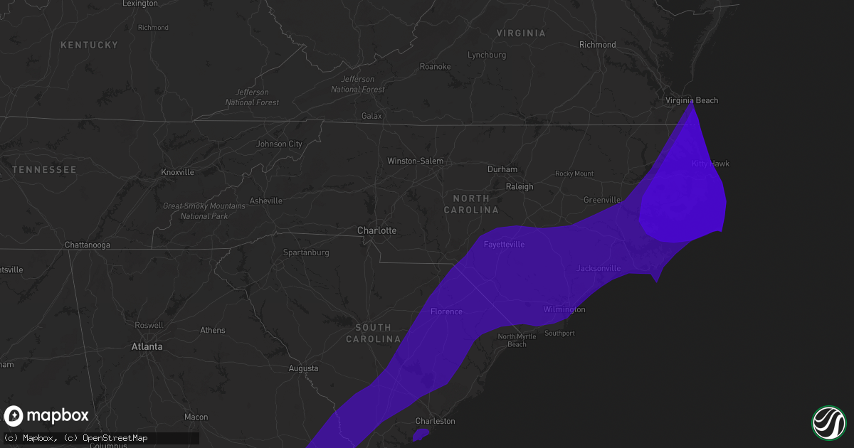
Hail Map in North Carolina on September 2, 2016
Get this storm
September 2 map
$229
one time, instant access
Download today. No call, no setup
Keep the $229
Bought the map and want the full workflow? Apply the entire $229 to a subscription within 7 days. None of it is wasted.
Every map, not just this one
This buys you this map. Subscription and you get every map we run, in the markets you choose from a few cities to whole states to nationwide. Plus real-time alerts the moment a storm fires.
Contact data
Name, contact info, occupancy, even credit band for addresses in the footprint. You go from where it hit to who to call.
Become the source they trust
Unlimited branding weather history reports on demand. You already have the documented answer ready for the property owner, and you are the one who showed up with it.
Property data and RoofTrace estimates
Pull up any address you have got, its value and the exact code rules for that jurisdiction, straight from One Click Code. Then RoofTrace estimates the squares, pitch, and roof value, priced the way you price.
Storm reports in North Carolina
North Carolina
| Date | Description |
|---|---|
| 09/02/20163:30 PM CDT | Tree down. Two fences blown down. Shingles blown off. |
| 09/02/201612:02 AM CDT | *** 3 inj *** tornado touched down in hatteras village and damaged several travel trailers with 3 minor injuries. |
| 09/02/201612:02 AM CDT | House destroyed on eagle pass rd. Due to possible tornado |
| 09/01/20169:02 PM CDT | Power poles leaning into road and damaged in williston from possible tornado. |
| 09/01/20168:23 PM CDT | Confirmed ef1 tornado near marshallberg. Trees snapped off and roof blown off house. |
| 09/01/20168:20 PM CDT | Confirmed ef1 tornado near straits. Several trees snapped off or blown down. Outbuildings damaged or destoyed. |
All States Impacted by Hail Map on September 2, 2016
Cities Impacted by Hail Map on September 2, 2016
- Otis, CO
- Kit Carson, CO
- Flagler, CO
- Seibert, CO
- Lolita, TX
- Wray, CO
- Eckley, CO
- Yuma, CO
- Haigler, NE
- Fleming, CO
- Sterling, CO
- Zahl, ND
- Sierra Blanca, TX
- Stafford, TX
- Sugar Land, TX
- Missouri City, TX
- Grenora, ND
- Burlington, CO
- Bethune, CO
- Littlefield, AZ
- Vona, CO
- Angleton, TX
- Colorado City, AZ
- Bay City, TX
- Stratton, CO
- Richmond, TX
- Van Vleck, TX
- Akron, CO
- Arriba, CO
- Brazoria, TX
- Eastpoint, FL
- Tallahassee, FL
- Saint Marks, FL
- Lloyd, FL
- Quitman, GA
- Carrabelle, FL
- Greenville, FL
- Boston, GA
- Sopchoppy, FL
- Thomasville, GA
- Panacea, FL
- Lanark Village, FL
- Perry, FL
- Dixie, GA
- Madison, FL
- Lamont, FL
- Monticello, FL
- Pinetta, FL
- Crawfordville, FL
- Lee, FL
- Ridgeville, SC
- Nags Head, NC
- Nahunta, GA
- Morehead City, NC
- Knotts Island, NC
- Pollocksville, NC
- Salters, SC
- Laurinburg, NC
- Beaufort, NC
- Mershon, GA
- Bamberg, SC
- Creswell, NC
- Maple, NC
- Fairfax, SC
- Adel, GA
- Turkey, NC
- Lulu, FL
- Du Pont, GA
- Trenton, NC
- Varnville, SC
- Whiteville, NC
- Morven, GA
- Cameron, SC
- Wewahitchka, FL
- Tifton, GA
- Delco, NC
- White Oak, NC
- Jesup, GA
- Cedar Key, FL
- Fort White, FL
- Telogia, FL
- Greenville, NC
- McColl, SC
- Attapulgus, GA
- Springfield, GA
- Reidsville, GA
- Denton, GA
- Nicholls, GA
- Ochlocknee, GA
- Gresham, SC
- Little Rock, SC
- Hope Mills, NC
- Aydlett, NC
- Mayo, FL
- Harrells, NC
- Glen Saint Mary, FL
- Davis, NC
- Clarendon, NC
- Linden, NC
- Santee, SC
- Ray City, GA
- Cove City, NC
- Tarawa Terrace, NC
- Starke, FL
- Longs, SC
- Sparks, GA
- South Mills, NC
- Winterville, NC
- Hahira, GA
- Pavo, GA
- Edenton, NC
- Council, NC
- Folkston, GA
- Wilmington, NC
- Mayesville, SC
- Pelham, GA
- Dorchester, SC
- Cheraw, SC
- Newport, NC
- Argyle, GA
- Dudley, NC
- Sumter, SC
- Kingstree, SC
- New Bern, NC
- Havelock, NC
- Smyrna, NC
- Gainesville, FL
- Kitty Hawk, NC
- Bowman, SC
- Wray, GA
- Micanopy, FL
- Newington, GA
- Stockton, GA
- Columbia, NC
- Summerville, SC
- Harbinger, NC
- Society Hill, SC
- Newberry, FL
- Virginia Beach, VA
- New Zion, SC
- Lake Park, GA
- Lane, SC
- Ludowici, GA
- White Oak, GA
- Jasper, FL
- Albertson, NC
- Engelhard, NC
- Round O, SC
- Conway, SC
- McAlpin, FL
- Richlands, NC
- Waynesville, GA
- Ernul, NC
- Erwin, NC
- Hookerton, NC
- Blounts Creek, NC
- Bonneau, SC
- Dover, NC
- Sanderson, FL
- Old Town, FL
- Luray, SC
- Plymouth, NC
- Salemburg, NC
- Statenville, GA
- Currituck, NC
- Pinewood, SC
- La Grange, NC
- Cedar Island, NC
- Greeleyville, SC
- Aurora, NC
- Raiford, FL
- Ocilla, GA
- Salem, FL
- Saint Pauls, NC
- Brunson, SC
- Godwin, NC
- Summerton, SC
- Kinston, NC
- Currie, NC
- Early Branch, SC
- Wallace, NC
- Lumberton, NC
- Olanta, SC
- Jarvisburg, NC
- Blackshear, GA
- Alapaha, GA
- Bennettsville, SC
- Lake City, SC
- Fort Bragg, NC
- Garland, NC
- Whigham, GA
- Lake Butler, FL
- Williston, FL
- Supply, NC
- Climax, GA
- West Green, GA
- Stedman, NC
- Effingham, SC
- Brooker, FL
- Pink Hill, NC
- Florence, SC
- Pearson, GA
- Patterson, GA
- Kill Devil Hills, NC
- Hampstead, NC
- Tillman, SC
- Alma, GA
- Gloucester, NC
- Autryville, NC
- Steinhatchee, FL
- Spring Lake, NC
- Bolton, NC
- Coinjock, NC
- Otter Creek, FL
- Sylvania, GA
- Washington, NC
- Douglas, GA
- Uvalda, GA
- Bayboro, NC
- Lynchburg, SC
- Emerald Isle, NC
- Manns Harbor, NC
- Dunn, NC
- Saint George, SC
- Day, FL
- Ellabell, GA
- Clinton, NC
- Naylor, GA
- Waves, NC
- Elizabeth City, NC
- Frisco, NC
- Register, GA
- Seven Springs, NC
- Wade, NC
- Orrum, NC
- Bloomingdale, GA
- Garnett, SC
- Lake View, SC
- Rowesville, SC
- Hampton, SC
- Cobbtown, GA
- Grandy, NC
- Surrency, GA
- Lumber Bridge, NC
- Hartsville, SC
- Cerro Gordo, NC
- Maple Hill, NC
- Wagram, NC
- Bladenboro, NC
- Ridgeland, SC
- Hinesville, GA
- Galivants Ferry, SC
- Turbeville, SC
- Magnolia, NC
- Rocky Point, NC
- Point Harbor, NC
- Kenansville, NC
- Pulaski, GA
- Moyock, NC
- Valdosta, GA
- Olar, SC
- Laurel Hill, NC
- Homerville, GA
- Wallace, SC
- Goldsboro, NC
- Meigs, GA
- Fairfield, NC
- Poplar Branch, NC
- Shiloh, NC
- Merritt, NC
- Cameron, NC
- Deep Run, NC
- Warsaw, NC
- Aynor, SC
- Lowland, NC
- Screven, GA
- Claxton, GA
- Alcolu, SC
- Clio, SC
- Mount Olive, NC
- Barco, NC
- Waycross, GA
- Lakeland, GA
- Faison, NC
- Bath, NC
- Eutawville, SC
- Riegelwood, NC
- Sellers, SC
- Moncks Corner, SC
- Scranton, SC
- Chesapeake, VA
- Harleyville, SC
- Willard, NC
- Salvo, NC
- Pembroke, GA
- Barwick, GA
- Rodanthe, NC
- Stumpy Point, NC
- Hazlehurst, GA
- Pinetown, NC
- Walterboro, SC
- Teachey, NC
- Port Saint Joe, FL
- Glennville, GA
- Vanceboro, NC
- Wellborn, FL
- Latta, SC
- Reddick, FL
- Guyton, GA
- Avon, NC
- Corolla, NC
- Omega, GA
- Cross City, FL
- Chiefland, FL
- Atlantic Beach, NC
- Hilliard, FL
- Estill, SC
- Ulmer, SC
- Lake Waccamaw, NC
- Fork, SC
- Enigma, GA
- Fair Bluff, NC
- Stacy, NC
- Hortense, GA
- Sneads Ferry, NC
- Broxton, GA
- Bryceville, FL
- Morriston, FL
- Beulaville, NC
- Shannon, NC
- Gibson, NC
- Moultrie, GA
- Burgaw, NC
- Smoaks, SC
- Apalachicola, FL
- Rose Hill, NC
- Orangeburg, SC
- Wanchese, NC
- Ambrose, GA
- Metter, GA
- Hallsboro, NC
- Mullins, SC
- Vance, SC
- Statesboro, GA
- Bishopville, SC
- Branford, FL
- Castle Hayne, NC
- Lake City, FL
- Millwood, GA
- Midway Park, NC
- Evergreen, NC
- Moody Afb, GA
- Midway, FL
- Axson, GA
- Hemingway, SC
- Pamplico, SC
- Jacksonville, NC
- Elloree, SC
- Vandemere, NC
- Lyons, GA
- Hartsfield, GA
- Pantego, NC
- Hubert, NC
- Coolidge, GA
- Winnabow, NC
- Lawtey, FL
- Hamer, SC
- Timmonsville, SC
- Manning, SC
- Holly Ridge, NC
- Atkinson, NC
- Ehrhardt, SC
- Tar Heel, NC
- Chadbourn, NC
- Elizabethtown, NC
- Fargo, GA
- Barney, GA
- Red Springs, NC
- Scranton, NC
- Dillon, SC
- Shawboro, NC
- Live Oak, FL
- Johnsonville, SC
- Ivanhoe, NC
- Ayden, NC
- Nakina, NC
- Parkton, NC
- Buxton, NC
- Darlington, SC
- Havana, FL
- White Springs, FL
- Swansboro, NC
- Kelly, NC
- Green Sea, SC
- Odum, GA
- Bolivia, NC
- Atlantic, NC
- Blenheim, SC
- Ocracoke, NC
- Cottageville, SC
- Marion, SC
- Maxton, NC
- Ruffin, SC
- Clarkton, NC
- Clyo, GA
- Collins, GA
- Fayetteville, NC
- Baxley, GA
- Hertford, NC
- Raeford, NC
- Brooklet, GA
- Wrightsville Beach, NC
- Bristol, GA
- Chinquapin, NC
- Norman Park, GA
- Rincon, GA
- Saint George, GA
- Bristol, FL
- Stella, NC
- Leland, NC
- Nichols, SC
- Tabor City, NC
- Jacksonville, FL
- Manor, GA
- Grimesland, NC
- Salter Path, NC
- Edward, NC
- Islandton, SC
- Saint Stephen, SC
- Quincy, FL
- Cairo, GA
- Nashville, GA
- Powells Point, NC
- Bronson, FL
- Roseboro, NC
- Vass, NC
- Willacoochee, GA
- Alachua, FL
- Camden, NC
- Roper, NC
- Marston, NC
- Marshallberg, NC
- Grifton, NC
- Pope Army Airfield, NC
- Loris, SC
- Hatteras, NC
- Rowland, NC
- Williams, SC
- Bell, FL
- Reevesville, SC
- Calypso, NC
- Berlin, GA
- Cades, SC
- Hosford, FL
- Manteo, NC
- Branchville, SC
- Southport, NC
- Arapahoe, NC
- Grantsboro, NC
- Gable, SC
- O'Brien, FL
- Hobucken, NC
- Newton Grove, NC
- Fairmont, NC
- Inglis, FL
- Pembroke, NC
- Elliott, SC
- Jamesville, NC
- Camp Lejeune, NC
- Hoboken, GA
- Ellenton, GA
- Sealevel, NC
- High Springs, FL
- Ash, NC
- Fort Stewart, GA
- Pineville, SC
- Oriental, NC
- Pinopolis, SC
- Swanquarter, NC
- Cross, SC
- Jennings, FL
- Maysville, NC
- Nesmith, SC
- Andrews, SC
- Coward, SC
- Allendale, SC
- Lamar, SC
- Chocowinity, NC
- Jamestown, SC
- Pineland, SC
- Lodge, SC
- Archer, FL
- Macclenny, FL
- Horseshoe Beach, FL
- Holly Hill, SC
- Belhaven, NC
- Lenox, GA
- Crystal River, FL
- Trenton, FL
- Cope, SC
- Yemassee, SC
- Dunnellon, FL
- Harkers Island, NC
- Edisto Island, SC
- Wadmalaw Island, SC
- Johns Island, SC


