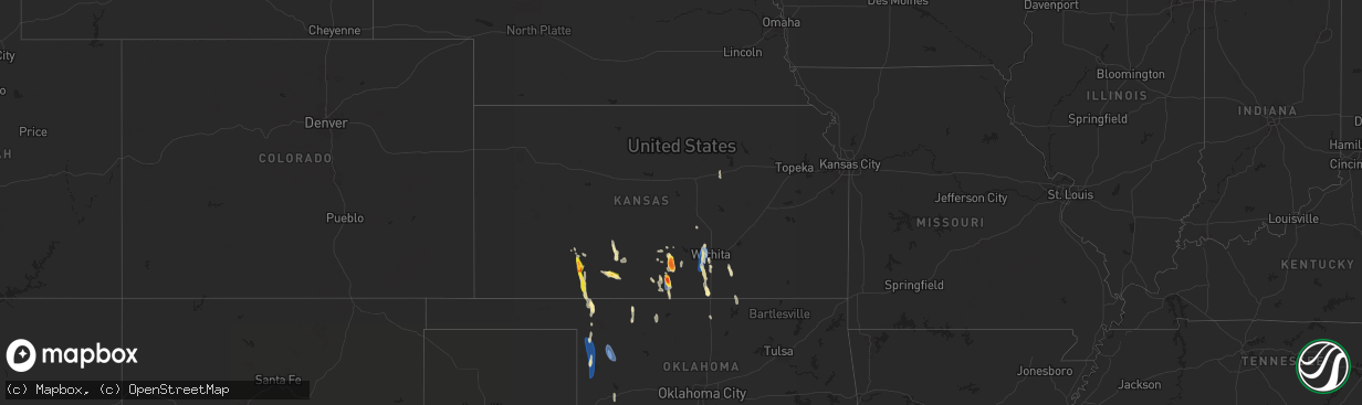
Hail Map in Kansas on September 1, 2025
The weather event in Kansas on September 1, 2025 includes Hail and Wind maps. 4 states and 107 cities were impacted and suffered possible damage. The total estimated number of properties impacted is 2,870.
Want more than just the map?
Turn this storm into a full workflow.
- Owner + property data so you know who to knock
- OnDemand branded weather history reports to win the "did we even have hail?" argument
- RoofTrace estimate so reps stop guessing numbers at the door
Bought this map? Upgrade within 7 days and we'll credit the $230. (10-15 min setup call)
Hail
Wind
2,870
Estimated number of impacted properties by a 1.00" hail or larger678
Estimated number of impacted properties by a 1.75" hail or larger269
Estimated number of impacted properties by a 2.50" hail or largerStorm reports in Kansas
Kansas
| Date | Description |
|---|---|
| 09/01/20256:12 PM CDT | Hailstones range from quarter size to tennis ball size. |
| 09/01/20256:08 PM CDT | A local report indicates 1.25 inch wind near Attica |
| 09/01/20256:08 PM CDT | Estimating 60 mph winds with power line flashes. |
| 09/01/20255:36 PM CDT | 60-65 mph wind gust. |
| 09/01/20255:30 PM CDT | Delayed report - shared via kake on facebook. Appeared close to 3.75 in. In image. |
| 09/01/20255:28 PM CDT | A local report indicates 60 MPH wind near 3 WSW Wichita Eisenhowe |
| 09/01/20255:20 PM CDT | Estimated 70 mph winds and quarter size hail. |
| 09/01/20255:18 PM CDT | Large... Irregular shaped hail. At least quarter size. |
| 09/01/20255:02 PM CDT | Up to 10 inch diameter tree branches down... A carport flipped on end... Downed power line. |
| 09/01/20252:45 PM CDT | A local report indicates 1.75 inch wind near 3 W Bloom |
| 09/01/20252:45 PM CDT | Corrects previous hail report from 3 w bloom. Report made via social media. |
| 09/01/20252:42 PM CDT | A local report indicates 1.00 inch wind near 1 W Bloom |
All States Impacted by Hail Map on September 1, 2025
Cities Impacted by Hail Map on September 1, 2025
- Dodge City, KS
- Minneola, KS
- Abilene, KS
- Ashland, KS
- Mullinville, KS
- Enterprise, KS
- Buffalo, OK
- Haviland, KS
- Coldwater, KS
- Wilmore, KS
- Protection, KS
- Lewis, KS
- Kinsley, KS
- Rosston, OK
- Buhler, KS
- Greensburg, KS
- Burrton, KS
- Douglass, KS
- Augusta, KS
- Laverne, OK
- Ambrose, ND
- Rock, KS
- Winfield, KS
- Kingman, KS
- Fargo, OK
- Gladstone, ND
- Taylor, ND
- Maize, KS
- Valley Center, KS
- Colwich, KS
- Wichita, KS
- Goddard, KS
- Viola, KS
- Clearwater, KS
- Spivey, KS
- Gage, OK
- Minot, ND
- Haysville, KS
- Conway Springs, KS
- Sawyer, ND
- Alamo, ND
- Attica, KS
- Richardton, ND
- Ford, KS
- Peck, KS
- Mulvane, KS
- Shattuck, OK
- Arnett, OK
- Sharon, OK
- Vici, OK
- Lefor, ND
- Sharon, KS
- Arkansas City, KS
- Belle Plaine, KS
- Medicine Lodge, KS
- Mott, ND
- Regent, ND
- Wellington, KS
- Newkirk, OK
- Harper, KS
- Turon, KS
- Cunningham, KS
- Anthony, KS
- Kaw City, OK
- Waldron, KS
- Hannah, ND
- South Haven, KS
- Lancaster, MN
- Amorita, OK
- Cheyenne, OK
- Crawford, OK
- Camargo, OK
- Caldwell, KS
- Taloga, OK
- Tonkawa, OK
- Canute, OK
- Hallock, MN
- Lake Bronson, MN
- Karlstad, MN
- Halma, MN
- Hazelton, KS
- Pretty Prairie, KS
- Arlington, KS
- Kennedy, MN
- Zenda, KS
- Murdock, KS
- Alva, OK
- Waynoka, OK
- Strandquist, MN
- Cherokee, OK
- Carmen, OK
- Aline, OK
- Ashby, MN
- Evansville, MN
- Cleo Springs, OK
- Chester, OK
- Fairview, OK
- Ringwood, OK
- Middle River, MN
- Strathcona, MN
- Ada, MN
- Barrett, MN
- Pine River, MN
- Pequot Lakes, MN
- Morris, MN
- Hoffman, MN
- Barnesville, MN


