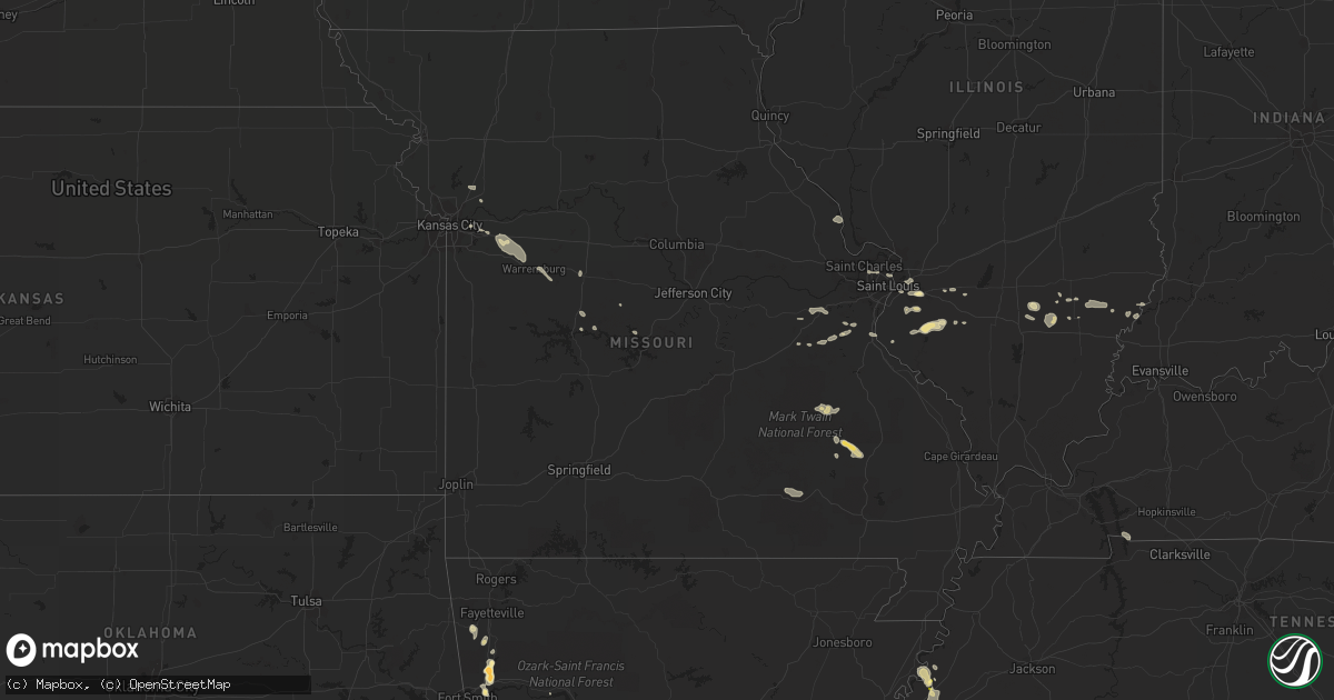
Hail Map in Missouri on September 1, 2013
Get this storm
September 1 map
$229
one time, instant access
Download today. No call, no setup
Keep the $229
Bought the map and want the full workflow? Apply the entire $229 to a subscription within 7 days. None of it is wasted.
Every map, not just this one
This buys you this map. Subscription and you get every map we run, in the markets you choose from a few cities to whole states to nationwide. Plus real-time alerts the moment a storm fires.
Contact data
Name, contact info, occupancy, even credit band for addresses in the footprint. You go from where it hit to who to call.
Become the source they trust
Unlimited branding weather history reports on demand. You already have the documented answer ready for the property owner, and you are the one who showed up with it.
Property data and RoofTrace estimates
Pull up any address you have got, its value and the exact code rules for that jurisdiction, straight from One Click Code. Then RoofTrace estimates the squares, pitch, and roof value, priced the way you price.
Storm reports in Missouri
Missouri
| Date | Description |
|---|---|
| 09/01/201310:55 AM CDT | A tree was reported downed on county road 513 southeast of vienna. |
| 09/01/20139:55 AM CDT | Trees down. Estimated wind gust of 67 mph on home weather system. |
| 09/01/20139:50 AM CDT | Numerous reports of trees and powerlines down over southwestern miller county generally from near rocky mount to near kaiser. Time of event estimated from radar. |
| 09/01/20139:50 AM CDT | Boat dock damaged and detached from marina. |
| 09/01/20139:45 AM CDT | Tree down in versailles. Additional downed trees across the county. |
| 09/01/20139:30 AM CDT | Trees down and boat docks damaged on coffman bend. |
| 09/01/20139:28 AM CDT | Several large tree limbs down with the largest 12 inches in diameter. Time of event estimated from radar. |
| 09/01/20139:28 AM CDT | A local report indicates 1.00 inch wind near 3 SE ZORA |
| 09/01/20139:09 AM CDT | A local report indicates 59 MPH wind near 4 E SEDALIA |
| 09/01/20139:00 AM CDT | One large tree...power pole...and power lines down. The tree is blocking a roadway. |
| 09/01/20138:57 AM CDT | Delayed report...trees down on power lines in la monte |
| 09/01/20138:30 AM CDT | 3 inch tree branch blown down |
| 09/01/20138:28 AM CDT | Tree down and a power pole blown down in town |
All States Impacted by Hail Map on September 1, 2013
Cities Impacted by Hail Map on September 1, 2013
- Umpire, AR
- Mena, AR
- Trinchera, CO
- Mancelona, MI
- Versailles, MO
- Cary, NC
- Morrisville, NC
- Raleigh, NC
- Winslow, AR
- West Fork, AR
- Bay City, MI
- Bates City, MO
- Odessa, MO
- Sims, NC
- Bailey, NC
- Addieville, IL
- Saint Libory, IL
- Marissa, IL
- Lenzburg, IL
- New Athens, IL
- Sheboygan, WI
- Lockesburg, AR
- Bluford, IL
- Texico, IL
- Booneville, AR
- Havana, AR
- Farmington, MI
- Southfield, MI
- Ohatchee, AL
- Ragland, AL
- Iuka, IL
- Belleview, MO
- Vandervoort, AR
- Cass City, MI
- Caro, MI
- New Harmony, IN
- Poseyville, IN
- Wadesville, IN
- Alma, AR
- Mountainburg, AR
- Kenly, NC
- Middlesex, NC
- Great Valley, NY
- Kill Buck, NY
- Aurora, NC
- Leland, IL
- Sheridan, IL
- Milton, FL
- Van Buren, MO
- Fremont, MO
- Stafford, NY
- Pavilion, NY
- Huntsville, AL
- Patterson, MO
- Des Arc, MO
- Silva, MO
- Annapolis, MO
- Hendersonville, NC
- Fletcher, NC
- Moreland, GA
- Greenville, GA
- Grantville, GA
- Luthersville, GA
- Holt, FL
- Munford, TN
- Burlison, TN
- Brighton, TN
- Drummonds, TN
- Kinston, AL
- Warsaw, MO
- Fort Pierce, FL
- Essexville, MI
- Pottsville, AR
- Waldron, AR
- Milford, MI
- Linden, MI
- Howell, MI
- Walled Lake, MI
- White Lake, MI
- Wixom, MI
- Commerce Township, MI
- Holly, MI
- Fenton, MI
- Hartland, MI
- Highland, MI
- West Bloomfield, MI
- Brighton, MI
- Novi, MI
- Pleasant Garden, NC
- West Bend, WI
- Allenton, WI
- Durham, NC
- Amherst Junction, WI
- Iola, WI
- Ogdensburg, WI
- Scandinavia, WI
- Custer, WI
- Nelsonville, WI
- Manawa, WI
- Stevens Point, WI
- New Market, AL
- Atoka, TN
- Millington, TN
- Anderson, SC
- Belton, SC
- Honea Path, SC
- Joliet, IL
- Sandusky, MI
- Snover, MI
- Mulberry, AR
- Chester, AR
- Quemado, NM
- Somerville, AL
- Corunna, MI
- Owosso, MI
- Prairie Grove, AR
- Lincoln, AR
- Henning, TN
- Paris, AR
- Nashville, AR
- Atmore, AL
- Eden, WI
- Campbellsport, WI
- Subiaco, AR
- Keenes, IL
- Wayne City, IL
- Sims, IL
- Taylorsville, NC
- Fairfield, IL
- Albion, IL
- Mount Erie, IL
- Golden Gate, IL
- West Salem, IL
- Cisne, IL
- Hillsboro, MO
- Trenton, IL
- Union Grove, AL
- East Troy, WI
- Ringgold, GA
- Tunnel Hill, GA
- Olathe, KS
- Aulander, NC
- O'Fallon, IL
- Belleville, IL
- Deckerville, MI
- Albertville, AL
- Guntersville, AL
- Clermont, FL
- Chapel Hill, NC
- Saint Ann, MO
- Bridgeton, MO
- Saint Louis, MO
- Maryland Heights, MO
- Jessieville, AR
- Dierks, AR
- Sedalia, MO
- Laceys Spring, AL
- Telephone, TX
- Ivanhoe, TX
- Brillion, WI
- Gadsden, AL
- Hartford, AL
- Stringtown, OK
- Indiantown, FL
- Hatfield, AR
- Cove, AR
- Atkins, AR
- Russellville, AR
- Burlington, WI
- Lavaca, AR
- Saint Johns, AZ
- West Chicago, IL
- Winfield, IL
- Wheaton, IL
- Warrenville, IL
- Tijeras, NM
- Dardanelle, AR
- Fults, IL
- Pie Town, NM
- Equality, AL
- Ola, AR
- Millstadt, IL
- Freeburg, IL
- Lowland, NC
- New Carlisle, IN
- Thomasville, GA
- Antioch, IL
- Spring Grove, IL
- Fox Lake, IL
- Windsor, NC
- Granite Falls, NC
- Woodland, AL
- Wedowee, AL
- Wickliffe, KY
- Kewaskum, WI
- Reedsville, WI
- Mount Carmel, IL
- Van Buren, AR
- Paron, AR
- Little Rock, AR
- Magazine, AR
- Mineral Springs, AR
- Delaware, AR
- Eva, AL
- Auburn, NE
- Selma, NC
- New Hope, AL
- Owens Cross Roads, AL
- Port Saint Lucie, FL
- Talihina, OK
- Wister, OK
- Patoka, IN
- Lomira, WI
- Union, MO
- Allendale, IL
- Barrington, IL
- Allegany, NY
- Samson, AL
- Randleman, NC
- Wellesley, MA
- Dover, MA
- Natick, MA
- Dyer, AR
- Gadsden, SC
- Fairgrove, MI
- Akron, MI
- Ubly, MI
- Marlette, MI
- Salem, WI
- Oshkosh, WI
- Serena, IL
- East Saint Louis, IL
- Palms, MI
- Villa Ridge, MO
- Robertsville, MO
- Elgin, IL
- Camden, NY
- Covington, TN
- Mechanicsburg, PA
- Heavener, OK
- Hartwell, GA
- Florala, AL
- Sells, AZ
- New Blaine, AR
- Ashland, AL
- Cragford, AL
- Horatio, AR
- Williamstown, NY
- Mount Vernon, IN
- De Soto, KS
- Waverly Hall, GA
- Ellerslie, GA
- Richwoods, MO
- Lonedell, MO
- Wake Forest, NC
- Cairo, GA
- Chicago Heights, IL
- Olympia Fields, IL
- Matteson, IL
- Country Club Hills, IL
- Flossmoor, IL
- Homewood, IL
- Park Forest, IL
- Lakewood, NY
- Antlers, OK
- Fairview Heights, IL
- Nicholson, GA
- Ravenna, TX
- Batavia, NY
- Sylacauga, AL
- Johnsonville, IL
- Glen Ellyn, IL
- Alden, MI
- Mundelein, IL
- Grayslake, IL
- Romeoville, IL
- Lockport, IL
- Plainfield, IL
- Crest Hill, IL
- Foley, MO
- Elsberry, MO
- Hudson, NC
- Lenoir, NC
- Hodgen, OK
- Kearney, MO
- Holt, MO
- Round Lake, IL
- Ingleside, IL
- Lake Villa, IL
- Kalkaska, MI
- North Little Rock, AR
- Sherwood, AR
- Vulcan, MO
- Ellington, MO
- Bethel Springs, TN
- Cole Camp, MO
- Melvin, TX
- Mchenry, IL
- Ringwood, IL
- Dittmer, MO
- Festus, MO
- Herculaneum, MO
- Crystal City, MO
- Cedartown, GA
- Yatesville, GA
- Table Rock, NE
- Oak Grove, MO
- Grain Valley, MO
- Bogart, GA
- Evansville, IN
- Arab, AL
- Nashville, IL
- Hampshire, IL
- Deford, MI
- Kingston, MI
- Sebring, FL
- Rutherfordton, NC
- Lake Lure, NC
- Red Bud, IL
- Tully, NY
- Preble, NY
- Ithaca, NY
- Rinard, IL
- Homer, NY
- Waukesha, WI
- Excelsior Springs, MO
- Alpine, AL
- Watson, OK
- Lincoln, MO
- Independence, MO
- Homer Glen, IL
- Orland Park, IL
- Mokena, IL
- Mount Vernon, IL
- Lineville, AL
- Knob Noster, MO
- Warrensburg, MO
- Hellertown, PA
- Genoa City, WI
- Lake Geneva, WI
- Forest City, NC
- Bostic, NC
- Creedmoor, NC
- Whitesboro, OK
- Morganton, NC
- La Porte, IN
- Michigan City, IN
- Carsonville, MI
- Crossville, AL
- Boaz, AL
- Eastover, SC
- Rocky Mount, MO
- Toney, AL
- Barnesville, GA
- Centerview, MO
- Holden, MO
- Rosholt, WI
- Junction City, WI
- Bear Creek, WI
- Avon Park, FL
- Taylorsville, GA
- Bartelso, IL
- Carlyle, IL
- McIntosh, AL
- Ratcliff, AR
- Rocky Face, GA
- Wing, AL
- Andalusia, AL
- Elgin, SC
- Alva, FL
- Lehigh Acres, FL
- Fort Myers, FL
- Carpentersville, IL
- Hoffman Estates, IL
- Dundee, IL
- Caledonia, NY
- Heflin, AL
- Grubville, MO
- Piedmont, AL
- Wauconda, IL
- Breese, IL
- Aviston, IL
- Iuka, MS
- Tinley Park, IL
- Wilburton, OK
- Fond Du Lac, WI
- Sullivan, MO
- Cedar Hill, MO
- Bourbon, MO
- Hazel Green, AL
- Bone Gap, IL
- Chino Valley, AZ
- Hartman, AR
- Collinsville, IL
- Benton, PA
- Orangeville, PA
- Cadiz, KY
- Bumpus Mills, TN
- Hampton, AR
- Falconer, NY
- Gerry, NY
- McDavid, FL
- Jefferson, GA
- Bellaire, MI
- Kewadin, MI
- Rapid City, MI


