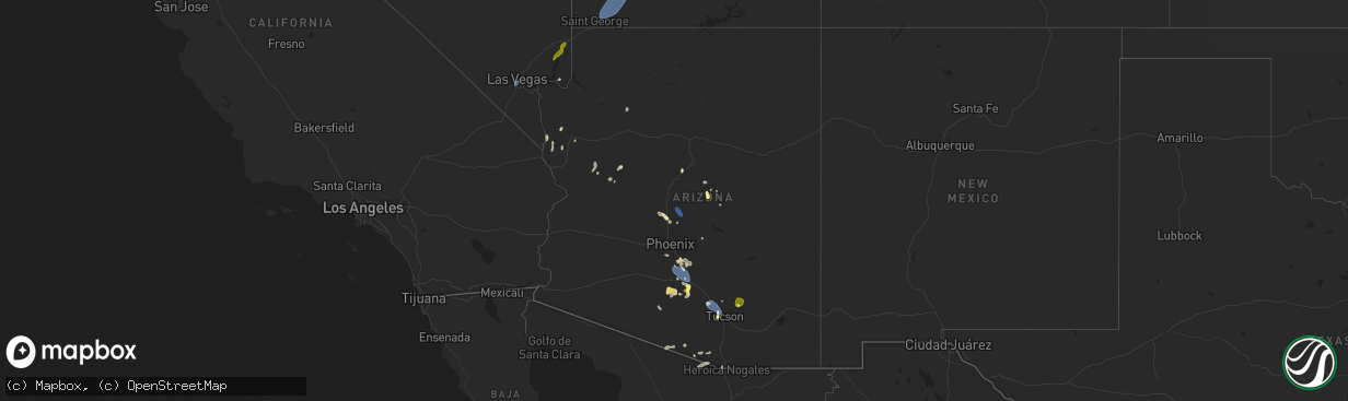
Hail Map in Arizona on August 31, 2023
The weather event in Arizona on August 31, 2023 includes Hail and Wind maps. 4 states and 49 cities were impacted and suffered possible damage. The total estimated number of properties impacted is 5,856.
Want more than just the map?
Turn this storm into a full workflow.
- Owner + property data so you know who to knock
- OnDemand branded weather history reports to win the "did we even have hail?" argument
- RoofTrace estimate so reps stop guessing numbers at the door
Bought this map? Upgrade within 7 days and we'll credit the $230. (10-15 min setup call)
Hail
Wind
5,856
Estimated number of impacted properties by a 1.00" hail or larger0
Estimated number of impacted properties by a 1.75" hail or larger0
Estimated number of impacted properties by a 2.50" hail or largerStorm reports in Arizona
Arizona
| Date | Description |
|---|---|
| 08/31/20235:40 PM CDT | A local report indicates 1.50 inch wind near 2 ESE Payson |
| 08/31/20235:32 PM CDT | A local report indicates 1.00 inch wind near Payson |
| 08/31/20234:45 AM CDT | A local report indicates 61 MPH wind near 1 NW Meadview |
| 08/31/20233:30 AM CDT | Time of occurrence estimated from radar and lightning data. |
| 08/31/20233:11 AM CDT | Winds of 58 mph or more lasted from 0109-0122 mst. |
| 08/30/202311:55 PM CDT | Awos station kluf luke afb glendal. |
| 08/30/202311:53 PM CDT | Asos station kdvt phoenix deer vly. |
| 08/30/202311:51 PM CDT | Asos station kphx phoenix sky hrbr. |
| 08/30/202311:35 PM CDT | Large 20 year old downed mesquite tree. Blocking road and sitting on car. Palo verdes as well. Spotter id: maa16058. |
| 08/30/202311:25 PM CDT | Mesonet station srp34 3.6 sw glendale |
| 08/30/202311:15 PM CDT | Mesonet station fw4391 avondale. |
| 08/30/202311:05 PM CDT | Mesonet station srp32 4.8 w phoenix |
| 08/30/202310:54 PM CDT | Corrects previous tstm wnd gst report from sky harbor airport. South winds at 47 mph... Gusting to 71 mph. |
| 08/30/202310:48 PM CDT | A couple mesquite trees |
| 08/30/202310:45 PM CDT | Mesonet station fw6363 paradise valley. |
| 08/30/202310:42 PM CDT | South winds at 47 mph... Gusting to 71 mph. 1/4 mile visibility. |
| 08/30/202310:10 PM CDT | Awos station ka39 ak-chin. |
| 08/30/202310:10 PM CDT | 43 mph sustained ssw winds with 3/4 mile visibility and haze. |
| 08/30/202310:02 PM CDT | ***delayed report***. |
| 08/30/20239:50 PM CDT | Ak-chin regional airport asos/awos reported a s wind at 41g59 with 1/2 mile visibility and haze. |
| 08/30/20238:50 PM CDT | A local report indicates 58 MPH wind near Pinal Airpark |
| 08/30/20238:47 PM CDT | Four power poles down on avra valley rd. Between garvey and trico. |
| 08/30/20238:31 PM CDT | Report of 64 mph wind gust. |
| 08/30/20238:25 PM CDT | Six power poles down on moore rd. Between clark farms rd and frontage rd. |
| 08/30/20238:00 PM CDT | Corrects previous tstm wnd gst report from 9 se marana. Report of 64 mph wind gust. |
| 08/30/20237:50 PM CDT | Multiple downed power poles near s. Corral way and w. Rafter circle st. |
Cities Impacted by Hail Map on August 31, 2023
- Payson, AZ
- Mount Lemmon, AZ
- Benson, AZ
- Overton, NV
- Tucson, AZ
- Las Vegas, NV
- Casa Grande, AZ
- Arizona City, AZ
- Eloy, AZ
- Marana, AZ
- Sedona, AZ
- Rimrock, AZ
- Sells, AZ
- Nogales, AZ
- Williams, AZ
- Young, AZ
- Arivaca, AZ
- Stanfield, AZ
- Maricopa, AZ
- Washington, UT
- Hurricane, UT
- New Harmony, UT
- Pine Valley, UT
- Leeds, UT
- La Verkin, UT
- Cedar City, UT
- Toquerville, UT
- Kanarraville, UT
- Virgin, UT
- Brian Head, UT
- Summit, UT
- Bagdad, AZ
- Prescott, AZ
- Chandler, AZ
- Bapchule, AZ
- Coolidge, AZ
- Phoenix, AZ
- New River, AZ
- Rio Grande City, TX
- Laveen, AZ
- Fort Mcdowell, AZ
- Scottsdale, AZ
- Carefree, AZ
- Cave Creek, AZ
- Queen Creek, AZ
- Bullhead City, AZ
- Golden Valley, AZ
- Kingman, AZ
- Yucca, AZ


