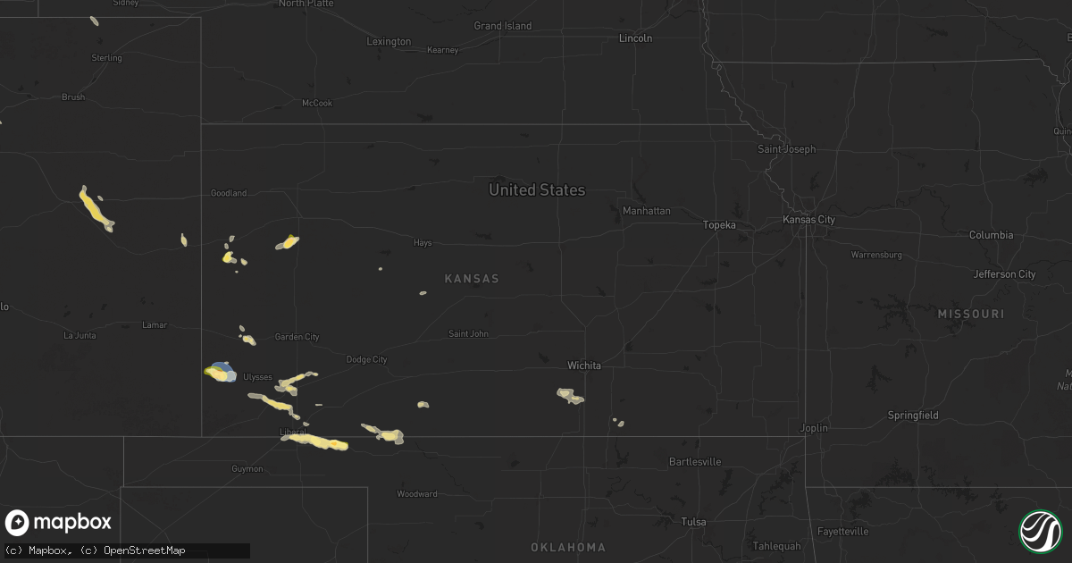
Hail Map in Kansas on August 27, 2025
Get this storm
August 27 map
$229
one time, instant access
Download today. No call, no setup
Keep the $229
Bought the map and want the full workflow? Apply the entire $229 to a subscription within 7 days. None of it is wasted.
Every map, not just this one
This buys you this map. Subscription and you get every map we run, in the markets you choose from a few cities to whole states to nationwide. Plus real-time alerts the moment a storm fires.
Contact data
Name, contact info, occupancy, even credit band for addresses in the footprint. You go from where it hit to who to call.
Become the source they trust
Unlimited branding weather history reports on demand. You already have the documented answer ready for the property owner, and you are the one who showed up with it.
Property data and RoofTrace estimates
Pull up any address you have got, its value and the exact code rules for that jurisdiction, straight from One Click Code. Then RoofTrace estimates the squares, pitch, and roof value, priced the way you price.
Storm reports in Kansas
Kansas
| Date | Description |
|---|---|
| 08/27/20256:31 PM CDT | A local report indicates 65 MPH wind near 1 E Kendall |
| 08/27/20255:35 PM CDT | Awos station kjhn johnson city. |
| 08/27/20255:07 PM CDT | A local report indicates 68 MPH wind near 2 N Johnson City |
| 08/27/20255:07 PM CDT | A local report indicates 1.00 inch wind near 2 N Johnson City |
| 08/26/202510:22 PM CDT | Estimated 45 to 60 mph winds with hail of dime to quarters... Time estimated by radar. |
| 08/26/202510:22 PM CDT | Dime to quarter size hail along with estimated 45-60 mph winds... Time estimated by radar. |
| 08/26/202510:22 PM CDT | Estimated 45 to 60 mph winds with hail of di |
| 08/26/202510:17 PM CDT | Still hailing at the time of the report. Hail was to the size of quarters along with winds gusting to 45 to 50 mph and heavy rain. |
| 08/26/20259:15 PM CDT | A local report indicates 63 MPH wind near 2 E Ulysses |
All States Impacted by Hail Map on August 27, 2025
Cities Impacted by Hail Map on August 27, 2025
- Miami, FL
- West Barnstable, MA
- Barnstable, MA
- Hyannis, MA
- Cummaquid, MA
- Yarmouth Port, MA
- Lucan, MN
- Milroy, MN
- Peyton, CO
- Renville, MN
- Saint Peter, MN
- Walnut Grove, MN
- Lamberton, MN
- Fort Lupton, CO
- Longmont, CO
- Manter, KS
- Johnson, KS
- Truckee, CA
- Redwood Falls, MN
- Padroni, CO
- Vesta, MN
- Wabasso, MN
- Keenesburg, CO
- Carson City, NV
- Peetz, CO
- New Ulm, MN
- Lafayette, MN
- Courtland, MN
- Springfield, MN
- Hanska, MN
- Colorado Springs, CO
- Waseca, MN
- Janesville, MN
- Mankato, MN
- Sanborn, MN
- Lake Crystal, MN
- Fountain, CO
- Jeffers, MN
- Tracy, MN
- Lakin, KS
- Kendall, KS
- Cleveland, MN
- Ulysses, KS
- Le Center, MN
- Waterville, MN
- Gazelle, CA
- Yreka, CA
- Kilkenny, MN
- Elysian, MN
- Genoa, CO
- Howell, UT
- Faribault, MN
- Currie, MN
- Hugoton, KS
- Moscow, KS
- Garvin, MN
- Slayton, MN
- Morristown, MN
- Warsaw, MN
- Rule, TX
- Graham, TX
- Hugo, CO
- Haskell, TX
- Rochester, MN
- Stewartville, MN
- Byron, MN
- Arriba, CO
- Dundas, MN
- Chatfield, MN
- Wykoff, MN
- Satanta, KS
- Winona, KS
- Spring Valley, MN
- Madelia, MN
- Nicollet, MN
- Oakley, KS
- Tyrone, OK
- Liberal, KS
- Lanesboro, MN
- Fountain, MN
- Utica, MN
- Flagler, CO
- Turpin, OK
- Sharon Springs, KS
- Wallace, KS
- Hayfield, MN
- Kasson, MN
- Forgan, OK
- Kismet, KS
- Arapahoe, CO
- Leoti, KS
- Sublette, KS
- Coral Springs, FL
- Tribune, KS
- Gate, OK
- Ransom, KS
- Plains, KS
- Rush Center, KS
- Copeland, KS
- Englewood, KS
- Rosston, OK
- Ashland, KS
- Buffalo, OK
- Conway Springs, KS
- Wellington, KS
- Clearwater, KS
- Belle Plaine, KS
- Mayfield, KS
- Coldwater, KS
- Arkansas City, KS
- Winfield, KS


