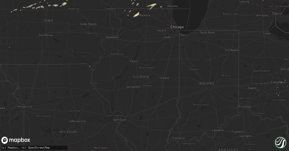
Hail Map in Illinois on August 26, 2018
Get this storm
August 26 map
$229
one time, instant access
Download today. No call, no setup
Keep the $229
Bought the map and want the full workflow? Apply the entire $229 to a subscription within 7 days. None of it is wasted.
Every map, not just this one
This buys you this map. Subscription and you get every map we run, in the markets you choose from a few cities to whole states to nationwide. Plus real-time alerts the moment a storm fires.
Contact data
Name, contact info, occupancy, even credit band for addresses in the footprint. You go from where it hit to who to call.
Become the source they trust
Unlimited branding weather history reports on demand. You already have the documented answer ready for the property owner, and you are the one who showed up with it.
Property data and RoofTrace estimates
Pull up any address you have got, its value and the exact code rules for that jurisdiction, straight from One Click Code. Then RoofTrace estimates the squares, pitch, and roof value, priced the way you price.
Storm reports in Illinois
Illinois
| Date | Description |
|---|---|
| 08/26/20186:42 AM CDT | At 1142 PM CDT, a severe thunderstorm was located over South Beloit, moving northeast at 50 mph. HAZARD...60 mph wind gusts. SOURCE...Radar indicated. IMPACT...Expect damage to roofs, siding, and trees. Locations impacted include... Beloit, Elkhorn, Delavan, Lake Geneva, Williams Bay, Walworth, Clinton, Fontana-On-Geneva Lake, Sharon, Darien, Como, Pell Lake, Richmond, Springfield, La Grange, Tiffany, Millard, Avalon, Delavan Lake and Abells Corners. |
| 08/26/20186:24 AM CDT | At 1124 PM CDT, a severe thunderstorm was located over Ridott, or 9 miles east of Freeport, moving northeast at 30 mph. HAZARD...60 mph wind gusts and quarter size hail. SOURCE...Radar indicated. IMPACT...Hail damage to vehicles is expected. Expect wind damage to roofs, siding, and trees. Locations impacted include... Rockford, Loves Park, Machesney Park, South Beloit, Rockton, Roscoe, Winnebago, Pecatonica, Durand and Lake Summerset. This includes... Rock Cut State Park, Rockford Speedway, andWinnebago County Fairgrounds. |
| 08/25/201811:38 PM CDT | Tree and a large branch downed near the same area. Time estimated per radar. |
All States Impacted by Hail Map on August 26, 2018
Cities Impacted by Hail Map on August 26, 2018
- Hager City, WI
- Welch, MN
- Almena, WI
- Chetek, WI
- Dallas, WI
- Cumberland, WI
- Comstock, WI
- Turtle Lake, WI
- Rice Lake, WI
- Barron, WI
- Cameron, WI
- Montpelier, ND
- Thief River Falls, MN
- Solway, MN
- Mayville, WI
- Argyle, IA
- Wayland, MO
- Valley City, ND
- Orr, MN
- Fond Du Lac, WI
- Eden, WI
- Warrens, WI
- Ponsford, MN
- Ely, MN
- Dunn Center, ND
- Hendrum, MN
- Spring Green, WI
- Lone Rock, WI
- New Richmond, WI
- Deer Park, WI
- Glenwood City, WI
- Star Prairie, WI
- Estelline, SD
- Lake Norden, SD
- Bigfork, MN
- Cook, MN
- Effie, MN
- Killdeer, ND
- Parshall, ND
- Roseglen, ND
- Halliday, ND
- Westport, SD
- Leola, SD
- Salix, IA
- Neenah, WI
- Oshkosh, WI
- Ludington, MI
- Selby, SD
- Juneau, WI
- Towner, ND
- Wayne, NE
- Wakefield, NE
- Julesburg, CO
- Rolette, ND
- Bemidji, MN
- Puposky, MN
- Brooklyn, WI
- Evansville, WI
- Chippewa Falls, WI
- Cedar Springs, MI
- Sparta, MI
- Stanton, NE
- Upland, NE
- Warren, MN
- Viking, MN
- East Grand Forks, MN
- Tamarack, MN
- Mcgregor, MN
- Aitkin, MN
- Leonard, MN
- Garrison, ND
- Gary, MN
- Fertile, MN
- Gilman, WI
- Albion, PA
- Wessington, SD
- Eau Claire, WI
- Cadott, WI
- Loyal, WI
- Greenwood, WI
- Cottage Grove, WI
- Sun Prairie, WI
- Marshall, WI
- Pierre, SD
- Onida, SD
- Blunt, SD
- Watertown, WI
- Johnson Creek, WI
- Tonalea, AZ
- Leupp, AZ
- Baldwin, WI
- Woodville, WI
- Ellsworth, WI
- Neshkoro, WI
- Montello, WI
- Iroquois, SD
- Carpenter, SD
- Ridott, IL
- Pecatonica, IL
- German Valley, IL
- Freeport, IL
- Minden, NE
- Plaza, ND
- Park Rapids, MN
- Palisade, MN
- New Lisbon, WI
- Necedah, WI
- Camp Douglas, WI
- Shell Rock, IA
- Allison, IA
- Parkersburg, IA
- Yale, SD
- Willow Lake, SD
- Jefferson, WI
- Argyle, MN
- Strandquist, MN
- Newfolden, MN
- New Hampton, IA
- Ionia, IA
- Michigan, ND
- Lakota, ND
- Weyerhaeuser, WI
- Almond, WI
- Amherst, WI
- Wisconsin Rapids, WI
- Williamsport, OH
- Circleville, OH
- Winslow, AZ
- Hayes, SD
- Fort Pierre, SD
- Harrold, SD
- North Freedom, WI
- Prairie Du Sac, WI
- Hazelton, ND
- Braddock, ND
- Linton, ND
- Napoleon, ND
- Streeter, ND
- Jud, ND
- Gackle, ND
- Kintyre, ND
- Blackduck, MN
- Pennington, MN
- Montague, MI
- Holton, MI
- Twin Lake, MI
- Whitehall, MI
- Monticello, WI
- Goldfield, IA
- Eagle Grove, IA
- Clarion, IA
- Ipswich, SD
- Claremont, SD
- Britton, SD
- Aberdeen, SD
- Hosmer, SD
- Hecla, SD
- Frederick, SD
- Columbia, SD
- Barnard, SD
- Roscoe, SD
- Houghton, SD
- Deer River, MN
- Cass Lake, MN
- West Bend, WI
- Bannister, MI
- Ashley, MI
- Loving, NM
- Dodge, ND
- Crane Lake, MN
- Kenyon, MN
- Babcock, WI
- Java, SD
- Portage, WI
- Columbus, WI
- Waterloo, WI
- Medford, WI
- Bagley, MN
- Hayward, WI
- Springbrook, WI
- Toronto, SD
- Clear Lake, SD
- Clifford, MI
- Kingston, MI
- Grant, NE
- Cambridge, WI
- Edgerton, WI
- Sac City, IA
- Ada, MN
- Sandstone, MN
- Danbury, WI
- Hinckley, MN
- Seneca, SD
- Crary, ND
- Warwick, ND
- Wrenshall, MN
- Ryder, ND
- Madison, WI
- Verona, WI
- Cross Plains, WI
- Blue Mounds, WI
- Mount Horeb, WI
- Middleton, WI
- Hannaford, ND
- Luverne, ND
- Kent City, MI
- Ravenna, MI
- Casnovia, MI
- Conklin, MI
- Squaw Lake, MN
- Hines, MN
- Naytahwaush, MN
- Waubun, MN
- Hixton, WI
- Nashua, IA
- Charles City, IA
- Lake Geneva, WI
- Genoa City, WI
- Mahnomen, MN
- Stoughton, WI
- Grygla, MN
- Remus, MI
- Blanchard, MI
- Mount Pleasant, MI
- Iron Ridge, WI
- Hartford, WI
- Colfax, WI
- Knapp, WI
- Pittsville, WI
- Gonvick, MN
- Hilbert, WI
- Black River Falls, WI
- Theresa, WI
- Allenton, WI
- Shevlin, MN
- Hope, ND
- Pender, NE
- Pilger, NE
- Hubbard, NE
- Winside, NE
- Wisner, NE
- Winnebago, NE
- Thurston, NE
- Emerson, NE
- Buffalo, ND
- Oriska, ND
- Marion, ND
- Litchville, ND
- Dickey, ND
- Milesville, SD
- Amery, WI
- Balsam Lake, WI
- Sharon, WI
- Twin Valley, MN
- Barneveld, WI
- Centuria, WI
- Marne, MI
- Grand Rapids, MI
- Westfield, WI
- Stanton, MI
- Vestaburg, MI
- Riverdale, MI
- Edmore, MI
- Cooperstown, ND
- Maiden Rock, WI
- Minot, ND
- Brodhead, WI
- Hillsboro, ND
- Faulkton, SD
- Cresbard, SD
- Lakeville, MN
- Elko New Market, MN
- Sloan, IA
- Beltrami, MN
- Muskegon, MI
- Fruitport, MI
- Pataskala, OH
- Menomonie, WI
- Elk Mound, WI
- Tolna, ND
- Pekin, ND
- Mcville, ND
- Saint Lawrence, SD
- Tenstrike, MN
- Clearbrook, MN
- Slinger, WI
- Odebolt, IA
- Early, IA
- Eleva, WI
- Independence, WI
- Hancock, WI
- Miller, SD
- Kabetogama, MN
- Delavan, WI
- Darien, WI
- Clinton, WI
- Beaver Dam, WI
- Fox Lake, WI
- Perrinton, MI
- Jackson, WI
- Richfield, WI
- Nekoosa, WI
- Arlington, WI
- Deforest, WI
- Dane, WI
- Dows, IA
- Alden, IA
- Popejoy, IA
- Augusta, WI
- Fairchild, WI
- Bowdle, SD
- Gully, MN
- Fosston, MN
- Fingal, ND
- Bay City, WI
- Venango, NE
- Eureka, SD
- Eagle, WI
- Minong, WI
- Elmwood, WI
- Columbus, OH
- Brookfield, WI
- Elm Grove, WI
- Milwaukee, WI
- Clayton, WI
- Clear Lake, WI
- Downing, WI
- Rosendale, WI
- Oakfield, WI
- Oconomowoc, WI
- Neosho, WI
- Hustisford, WI
- Mcfarland, WI
- Hartland, WI
- Hubertus, WI
- Nashotah, WI
- Deerfield, WI
- Colgate, WI
- Sullivan, WI
- Okauchee, WI
- Lake Mills, WI
- Helenville, WI
- Fort Atkinson, WI
- Ixonia, WI
- Latimer, IA
- Sheffield, IA
- Prairie Farm, WI
- Waupun, WI
- Harwood, ND
- Georgetown, MN
- Perley, MN
- Argusville, ND
- Pleasantville, OH
- Rushville, OH
- Borup, MN
- Trufant, MI
- Coral, MI
- New Auburn, WI
- Shawano, WI
- Clintonville, WI
- Wolsey, SD
- Webster City, IA
- Clarksville, IA
- Marion, WI
- Walcott, ND
- Stockton, IL
- Grand Haven, MI
- West Olive, MI
- Chillicothe, OH
- Rosemount, MN
- Farmington, MN
- Campbellsport, WI
- Kewaskum, WI
- Woolstock, IA
- Rubicon, WI
- Marble Rock, IA
- Manson, IA
- Pomeroy, IA
- Caro, MI
- Loman, MN
- Big Falls, MN
- Bruce, WI
- Holcombe, WI
- Edgeley, ND
- Highmore, SD
- Holabird, SD
- Audubon, MN
- Lake Park, MN
- Callaway, MN
- White Earth, MN
- Ogema, MN
- Belmond, IA
- Willard, WI
- Granville, ND
- Waunakee, WI
- Black Earth, WI
- Dazey, ND
- Lodi, WI
- Cedarburg, WI
- Grafton, WI
- Jacobson, MN
- Goodridge, MN
- Horace, ND
- Verndale, MN
- Durand, WI
- Mondovi, WI
- Eau Galle, WI
- Arkansaw, WI
- Shepherd, MI
- Mukwonago, WI
- Beulah, ND
- Golden Valley, ND
- Cannon Falls, MN
- Angora, MN
- Sauk City, WI
- Plain, WI
- Loganville, WI
- Saginaw, MI
- Reese, MI
- Frankenmuth, MI
- Bailey, MI
- Waukesha, WI
- Duncombe, IA
- Vincent, IA
- Lamoure, ND
- Alma, MI
- Saint Louis, MI
- Pearl City, IL
- Mayville, MI
- Makoti, ND
- Aplington, IA
- Six Lakes, MI
- Lakeview, MI
- Croswell, MI
- Ellendale, ND
- Hoskins, NE
- Geneva, IA
- Ackley, IA
- Plum City, WI
- Pepin, WI
- Rio, WI
- Poynette, WI
- Battle Lake, MN
- Northwood, ND
- East Troy, WI
- Midland, MI
- Prescott Valley, AZ
- Casselton, ND
- Newton, WI
- Breckenridge, MI
- Waverly, IA
- Plainfield, IA
- Littlefork, MN
- Grand Forks, ND
- Kathryn, ND
- Wales, WI
- Randolph, WI
- Cambria, WI
- Erskine, MN
- Webster, WI
- Brownsville, WI
- Cottonwood, AZ
- Spring Valley, WI
- Beldenville, WI
- Humboldt, IA
- Fort Dodge, IA
- Clare, IA
- Backus, MN
- Plainfield, WI
- Wild Rose, WI
- Cornell, WI
- Rockwell City, IA
- Grand Canyon, AZ
- Douglas, ND
- Sarles, ND
- Nevis, MN
- Monroe, WI
- Bloomer, WI
- Spring Lake, MN
- Greenville, MI
- Bejou, MN
- Pine River, MN
- Boyceville, WI
- Eldorado, WI
- Ripon, WI
- Pickett, WI
- Beloit, WI
- South Beloit, IL
- Caledonia, IL
- Avalon, WI
- Elkhorn, WI
- Janesville, WI
- Poplar Grove, IL
- Wilson, WI
- Fall River, WI
- Northome, MN
- Byron, MI
- Bancroft, MI
- Lisbon, ND
- Willow River, MN
- Sturgeon Lake, MN
- Applegate, MI
- Reedsburg, WI
- Berlin, ND
- International Falls, MN
- Veblen, SD
- Taylor, WI
- Owosso, MI
- Barnum, IA
- New Effington, SD
- Roberts, WI
- Hammond, WI
- Gardner, ND
- Big Rapids, MI
- Niagara, ND
- Petersburg, ND
- Hollandale, WI
- Lomira, WI
- Elwell, MI
- Sand Lake, MI
- Glenwood, IA
- Pacific Junction, IA
- Mcintosh, MN
- Stanwood, MI
- Vassar, MI
- Orient, OH
- Commercial Point, OH
- Ashville, OH
- Rosholt, SD
- Fairmount, ND
- Mequon, WI
- Pardeeville, WI
- Ithaca, MI
- Oregon, WI
- Meadowlands, MN
- Canyon, MN
- Max, MN
- Grand Marsh, WI
- Oxford, WI
- Bay City, MI
- Freeland, MI
- New Berlin, WI
- Dakota, IL
- Erie, ND
- Baileyville, IL
- Rock City, IL
- Stockholm, WI
- Badger, IA
- Dougherty, IA
- Thor, IA
- Iowa Falls, IA
- Lytton, IA
- Jolley, IA
- Osage, MN
- Winger, MN
- Castlewood, SD
- Melrose, WI
- Morley, MI
- Hillpoint, WI
- Lowell, WI
- Reeseville, WI
- Cranesville, PA
- Marlette, MI
- Clifford, ND
- South Saint Paul, MN
- Saint Paul, MN
- Baltimore, OH
- Bryant, SD
- Arlington, SD
- Baraboo, WI
- Merrimac, WI
- Fenton, MI
- Coopersville, MI
- Ayr, ND
- Wheatland, ND
- Arthur, ND
- Amenia, ND
- Forbes, ND
- Saint Croix Falls, WI
- Dresser, WI
- McConnell, IL
- Lena, IL
- Huron, SD
- Hornick, IA
- Claire City, SD
- Pentwater, MI
- Scottville, MI
- Lyndon Station, WI
- La Valle, WI
- Nome, ND
- Big Bend, WI
- Germantown, WI
- Menomonee Falls, WI
- Ganado, AZ
- Carson, IA
- Alma Center, WI
- Somerset, WI
- Osceola, WI
- Ashley, ND
- Timber Lake, SD
- Dupree, SD
- Meadow, SD
- Glencross, SD
- Trail City, SD
- Isabel, SD


