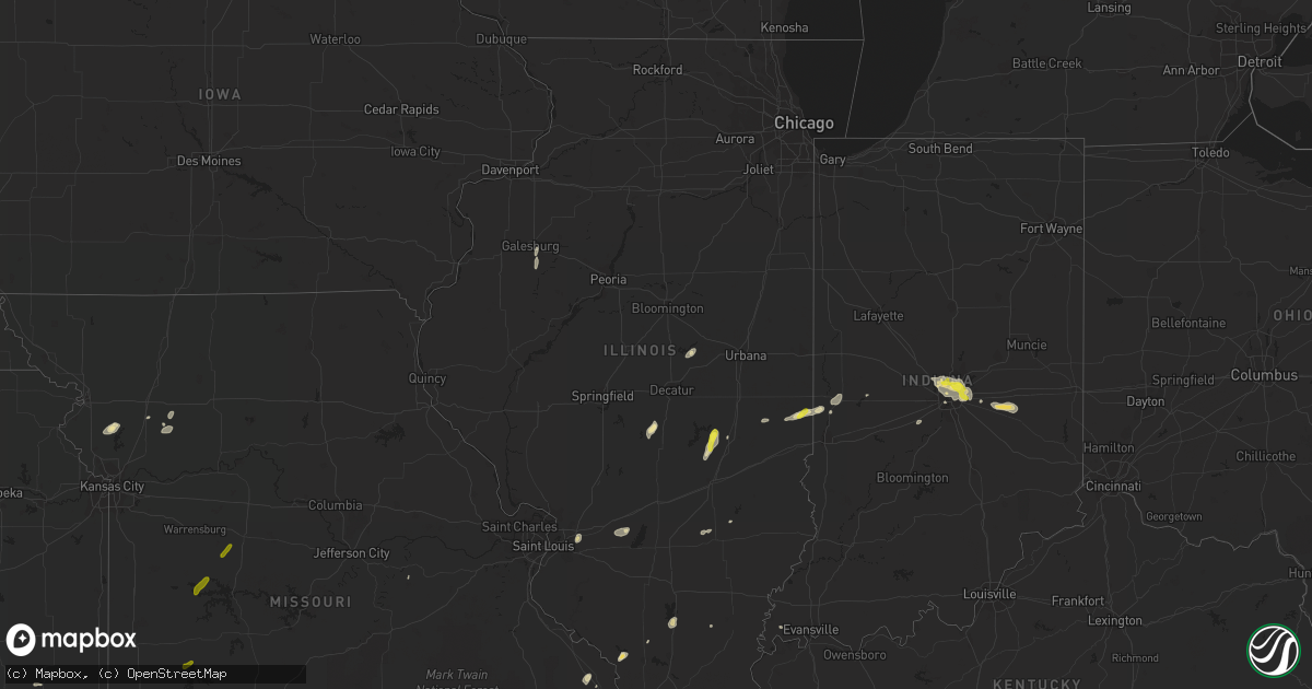
Hail Map in Illinois on August 26, 2016
Get this storm
August 26 map
$229
one time, instant access
Download today. No call, no setup
Keep the $229
Bought the map and want the full workflow? Apply the entire $229 to a subscription within 7 days. None of it is wasted.
Every map, not just this one
This buys you this map. Subscription and you get every map we run, in the markets you choose from a few cities to whole states to nationwide. Plus real-time alerts the moment a storm fires.
Contact data
Name, contact info, occupancy, even credit band for addresses in the footprint. You go from where it hit to who to call.
Become the source they trust
Unlimited branding weather history reports on demand. You already have the documented answer ready for the property owner, and you are the one who showed up with it.
Property data and RoofTrace estimates
Pull up any address you have got, its value and the exact code rules for that jurisdiction, straight from One Click Code. Then RoofTrace estimates the squares, pitch, and roof value, priced the way you price.
Storm reports in Illinois
Illinois
| Date | Description |
|---|---|
| 08/26/20166:10 PM CDT | Tree down on route 10 and west street. Tree down on lynn street. |
| 08/26/20164:50 PM CDT | Tree blown onto power lines on harrison st. |
| 08/26/20163:54 PM CDT | A local report indicates 1.00 inch wind near 2 S ALLENVILLE |
| 08/26/20162:50 PM CDT | Tree limbs blown onto 6 houses. 9 locations with power lines down. Most damage on the east side of town. Time estimated. |
| 08/26/20162:48 PM CDT | A local report indicates 1.00 inch wind near 3 NE PARIS |
| 08/26/20162:45 PM CDT | Multiple tree branches and limbs downed. Some limbs with 2-3 inch diameters. Time estimated by radar. |
All States Impacted by Hail Map on August 26, 2016
Cities Impacted by Hail Map on August 26, 2016
- Abilene, TX
- Ball Ground, GA
- Gorham, IL
- Murphysboro, IL
- Poplar Bluff, MO
- Selden, KS
- Mayer, AZ
- Crown King, AZ
- Fairdealing, MO
- Doniphan, MO
- Houston, MS
- Okolona, MS
- Herndon, KS
- Oberlin, KS
- Rushville, IN
- Morristown, IN
- Carthage, IN
- Arlington, IN
- Greenfield, IN
- Monroe, NC
- Yuma, CO
- Wray, CO
- Vernon, CO
- Eckley, CO
- Leoti, KS
- Springfield, TN
- Haigler, NE
- Maynard, AR
- Needles, CA
- Pontotoc, MS
- Polo, MO
- Cowgill, MO
- Thermopolis, WY
- Fancy Farm, KY
- Clayton, KS
- Norton, KS
- Lenora, KS
- Hardy, AR
- Williford, AR
- Erie, KS
- Galesburg, KS
- Trimble, MO
- Gower, MO
- Florence, TX
- Liberty Hill, TX
- Georgetown, TX
- Windsor, IL
- Strasburg, IL
- Gays, IL
- Fort Worth, TX
- Saint Francis, KS
- Cashion, OK
- Edmond, OK
- Yukon, OK
- Piedmont, OK
- Sand Springs, OK
- Mannford, OK
- Cleveland, OK
- Elfrida, AZ
- Weldon, IL
- Iron City, TN
- Houston, AL
- Wamego, KS
- Belvue, KS
- Paxico, KS
- Deadwood, SD
- Whitewood, SD
- Spearfish, SD
- Beulah, WY
- Sturgis, SD
- Lead, SD
- Bee Branch, AR
- New Hope, AL
- Weskan, KS
- Grover, CO
- Guthrie, OK
- El Reno, OK
- Indianapolis, IN
- Collinwood, TN
- Westpoint, TN
- Clinton, IN
- Carmel, IN
- Mccordsville, IN
- Zionsville, IN
- Huntsville, AL
- Union Grove, AL
- Tishomingo, OK
- McDonald, KS
- Ludell, KS
- Atwood, KS
- Waco, TX
- Blanco, TX
- Newcastle, WY
- Vaughn, NM
- Wallace, KS
- Sharon Springs, KS
- Hawk Springs, WY
- Oak Ridge, MO
- Galesburg, IL
- East Galesburg, IL
- Knoxville, IL
- Gilson, IL
- Somerville, AL
- Hartselle, AL
- Lagrange, WY
- Lawrenceburg, TN
- Greenville, IL
- Carlyle, IL
- Pocahontas, IL
- Myton, UT
- Edgerton, MO
- Pueblo, CO
- Rye, CO
- Avondale, CO
- Norcatur, KS
- Damascus, AR
- Falkville, AL
- Jackson, MO
- Whitewater, MO
- Burfordville, MO
- Oklahoma City, OK
- Hillsdale, WY
- Friedheim, MO
- Perryville, MO
- Bradenton, FL
- Benton, IL
- Terlton, OK
- Drumright, OK
- Jennings, OK
- Culbertson, NE
- Holly Pond, AL
- Paris, IL
- Hermosa, SD
- Franklin, TN
- Quincy, IL
- Liberty, IL
- Mattoon, IL
- Scottsboro, AL
- Woodville, AL
- Moody, TX
- Gatesville, TX
- Canton, GA
- Bristow, OK
- Keller, TX
- Pearce, AZ
- Humboldt, TN
- Hico, TX
- Duchesne, UT
- Cullman, AL
- Eva, AL
- Ingraham, IL
- Louisville, IL
- Cherokee, AL
- Assumption, IL
- Taylorville, IL
- Michie, TN
- Shiloh, TN
- Leopold, MO
- Marble Hill, MO
- Rapid City, SD
- Collinsville, IL
- Troy, IL
- Selmer, TN
- Centerville, TN
- Gadsden, TN
- Grandin, MO
- Oxly, MO
- Ravenden, AR
- Sarasota, FL
- Briggsdale, CO
- New Raymer, CO
- Laceys Spring, AL
- Florence, AL
- Houlka, MS
- Randolph, MS
- Fayetteville, TN
- Taft, TN
- Greenbrier, TN
- Joelton, TN
- McLeansboro, IL
- Adamsville, TN
- Winona, KS
- Owaneco, IL
- Stewardson, IL
- Petersburg, TN
- Gaylord, KS
- Kaibeto, AZ
- Mount Pleasant, TN
- Fulton, KY
- Hickman, KY
- Nolanville, TX
- Belton, TX
- Bullhead City, AZ
- Hampshire, TN
- Columbia, TN
- Bloomingdale, IN
- Montezuma, IN
- Rockville, IN
- Groveoak, AL
- Albertville, AL
- Geraldine, AL
- Arapahoe, CO
- Xenia, IL
- Hoxie, KS
- Neoga, IL
- Whittington, IL
- Mount Vernon, IN
- Millersville, MO
- Burns, WY
- Cheyenne, WY
- Ashland City, TN
- Pleasant View, TN
- Russellville, AL
- Mustang, OK
- Fischer, TX
- Elkville, IL
- Hohenwald, TN
- Summertown, TN
- Stonewall, OK
- Owens Cross Roads, AL
- Gurley, AL
- Brownsboro, AL
- Talking Rock, GA
- Ellijay, GA
- Dickson, TN
- Vanleer, TN
- Springville, TN
- Camden, TN
- Mansfield, TN
- Milburn, OK
- Yoder, WY
- Naples, FL
- Hereford, TX
- Ravenden Springs, AR
- Carr, CO
- Nunn, CO
- Turney, MO
- Cameron, MO
- Monrovia, IN
- Mooresville, IN
- Oldsmar, FL
- Safety Harbor, FL
- Wagon Mound, NM
- Clinton, SC
- Bland, MO
- Tuscumbia, AL
- Cypress Inn, TN
- Hamilton, MO
- Kingston, MO
- Alzada, MT
- Skull Valley, AZ
- Nashville, TN
- Pegram, TN
- Adrian, TX
- Rienzi, MS
- Scott City, KS
- Cross Hill, SC
- Salado, TX
- Breese, IL
- Stanley, NM
- Waynesboro, TN
- Farmer City, IL
- Piedmont, SD
- Friona, TX
- Addison, AL
- Winfield, AL
- Bruceton, TN
- Hebbronville, TX
- Rosedale, IN
- Elida, NM
- Mountain Rest, SC
- Muleshoe, TX
- Oakland, IL
- Cal Nev Ari, NV
- Hawley, TX
- Lake Powell, UT
- Russellville, IN
- Anton Chico, NM
- Prescott, AZ
- Guys, TN
- Leonard, TX
- Fe Warren Afb, WY
- Pine Bluffs, WY
- Stantonville, TN
- Vardaman, MS
- Bruce, MS
- Bonita Springs, FL
- Abingdon, IL
- Maquon, IL
- Dearborn, MO
- Cushing, OK
- Stroud, OK
- Laurens, SC
- Lutts, TN
- Waterloo, AL
- Walhalla, SC
- Primm Springs, TN
- Thompsons Station, TN
- Spring Hill, TN
- Santa Fe, TN
- Chandler, OK
- Stonington, IL
- Nemo, SD
- Lueders, TX
- Clinton, MO
- Deepwater, MO
- Stockton, MO
- Green Ridge, MO
- Windsor, MO
- Saint Onge, SD


