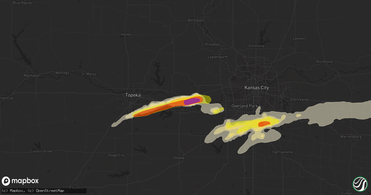
Hail Map in Lawrence, KS on August 24, 2016
Get this storm
August 24 map
$229
one time, instant access
Download today. No call, no setup
Keep the $229
Bought the map and want the full workflow? Apply the entire $229 to a subscription within 7 days. None of it is wasted.
Every map, not just this one
This buys you this map. Subscription and you get every map we run, in the markets you choose from a few cities to whole states to nationwide. Plus real-time alerts the moment a storm fires.
Contact data
Name, contact info, occupancy, even credit band for addresses in the footprint. You go from where it hit to who to call.
Become the source they trust
Unlimited branding weather history reports on demand. You already have the documented answer ready for the property owner, and you are the one who showed up with it.
Property data and RoofTrace estimates
Pull up any address you have got, its value and the exact code rules for that jurisdiction, straight from One Click Code. Then RoofTrace estimates the squares, pitch, and roof value, priced the way you price.
Storm reports in Lawrence, KS
Lawrence, KS
| Date | Description |
|---|---|
| 08/23/20167:37 PM CDT | Ping pong to tennis ball hail on i-70 |
| 08/23/20167:28 PM CDT | Near michigan and kansas turnpike |
| 08/23/20167:27 PM CDT | A local report indicates 70 MPH wind near LAWRENCE AIRPORT |
| 08/23/20167:26 PM CDT | Near midland junction |
| 08/23/20167:25 PM CDT | A local report indicates 62 MPH wind near LAWRENCE AIRPORT |
| 08/23/20167:22 PM CDT | 4 inch diameter tree limb down |
| 08/23/20167:21 PM CDT | 15 inch plus diameter tree blown down. |
| 08/23/20167:20 PM CDT | Via social media |
| 08/23/20167:20 PM CDT | 70 mph winds were also reported |
| 08/23/20167:18 PM CDT | Nickel to quarter |
All States Impacted by Hail Map on August 24, 2016
All Cities Impacted by Hail Map on August 24, 2016
- Fairland, IN
- Morristown, IN
- Fountaintown, IN
- New Palestine, IN
- Indianapolis, IN
- Marathon, TX
- Fort Stockton, TX
- Berryton, KS
- Wakarusa, KS
- Attica, IN
- Saint Martinville, LA
- Wellington, KS
- Pine Village, IN
- Boswell, IN
- Oxford, IN
- Romney, IN
- Lafayette, IN
- Westpoint, IN
- Ladoga, IN
- Roachdale, IN
- Lizton, IN
- Paola, KS
- Burrton, KS
- Clayton, IL
- Timewell, IL
- Mount Sterling, IL
- Rossville, IL
- Towanda, KS
- Linwood, KS
- Lecompton, KS
- Lawrence, KS
- Tonganoxie, KS
- Quincy, IL
- Warrensburg, MO
- Lawson, MO
- Polo, MO
- Crown King, AZ
- Perryton, TX
- Lebo, KS
- Waverly, KS
- Burlington, KS
- Matfield Green, KS
- Burns, KS
- Cassoday, KS
- El Dorado, KS
- Tipton, OK
- Headrick, OK
- Elmer, OK
- Louisburg, KS
- Jetmore, KS
- Sedona, AZ
- Flagstaff, AZ
- Marysville, KS
- Washington, KS
- Hollenberg, KS
- Bremen, KS
- Morrowville, KS
- Haddam, KS
- Hanover, KS
- Lexington, MO
- Hardin, MO
- Henrietta, MO
- Columbus, IN
- Eureka, IL
- Benton, KS
- Shelbyville, IN
- Madison, KS
- Olpe, KS
- Hartford, KS
- Williamsburg, KS
- Garnett, KS
- Tecumseh, KS
- Topeka, KS
- Concordia, MO
- Osborne, KS
- Downs, KS
- Stilwell, KS
- Grandview, MO
- Overland Park, KS
- Lees Summit, MO
- Kansas City, MO
- Belton, MO
- Potwin, KS
- Marshall, MO
- Nashville, IN
- Rea, MO
- Forest City, MO
- Craig, MO
- Bolckow, MO
- Savannah, MO
- Rulo, NE
- Fillmore, MO
- Rosendale, MO
- Maitland, MO
- Oregon, MO
- Mound City, MO
- Elbing, KS
- Newton, KS
- Peabody, KS
- Whitewater, KS
- Nardin, OK
- Blackwell, OK
- Blackburn, MO
- Alma, MO
- Malta Bend, MO
- Corder, MO
- Higginsville, MO
- Auburn, KS
- Slater, MO
- Olathe, KS
- De Soto, KS
- Waverly, MO
- Norborne, MO
- Dover, MO
- Hanston, KS
- Alpine, TX
- Zuni, NM
- Richmond, KS
- Hartford City, IN
- Dunkirk, IN
- Eaton, IN
- Wilmington, IL
- Kremlin, OK
- Enid, OK
- Meno, OK
- North Salem, IN
- Beardstown, IL
- Frederick, IL
- Nelson, MO
- Blue Springs, NE
- Princeton, KS
- Glasgow, MO
- Salisbury, MO
- Otley, IA
- Lewistown, IL
- Table Grove, IL
- Marietta, IL
- Cuba, IL
- Ipava, IL
- Smithfield, IL
- Sweet Springs, MO
- Picacho, NM
- Melvern, KS
- Crowell, TX
- Raymore, MO
- Garden City, TX
- Auburn, NE
- Johnson, NE
- Cimarron, KS
- Big Spring, TX
- Roswell, NM
- Tinnie, NM
- Chillicothe, TX
- Canton, IL
- Glasford, IL
- Hanna City, IL
- Trivoli, IL
- Peoria, IL
- Mapleton, IL
- Farmington, IL
- Midkiff, TX
- Cedar City, UT
- McCamey, TX
- Bonner Springs, KS
- Novelty, MO
- Coahoma, TX
- Ira, TX
- Snyder, TX
- Valley Falls, KS
- Odessa, MO
- Houstonia, MO
- Baton Rouge, LA
- Medford, OK
- Fairview, KS
- Morrill, KS
- Sabetha, KS
- Hiawatha, KS
- Elm Creek, NE
- Long Beach, MS
- Pekin, IL
- Pittsboro, IN
- Brownsburg, IN
- Kearney, NE
- Mansfield, IL
- Gilliam, MO
- Oak Grove, MO
- Bates City, MO
- Mayview, MO
- Wapello, IA
- Columbus Junction, IA
- Letts, IA
- Rankin, IL
- Pretty Prairie, KS
- Waukomis, OK
- Elizabethtown, IN
- Scipio, IN
- North Vernon, IN
- Seymour, IN
- South Haven, KS
- Crescent City, IL
- Gilman, IL
- Union Star, MO
- White Cloud, KS
- King City, MO
- Esbon, KS
- Spring Hill, KS
- Bucyrus, KS
- Kokomo, IN
- Camp Verde, AZ
- Toledo, IL
- Leonard, MO
- Clark, MO
- Moberly, MO
- Lewiston, NE
- Steinauer, NE
- Monroe, IA
- Swan, IA
- Barnes City, IA
- New Sharon, IA
- Midland, TX
- Odell, TX
- Vernon, TX
- Grain Valley, MO
- Versailles, IL
- Holden, MO
- Manito, IL
- Kingston Mines, IL
- Newkirk, OK
- Braman, OK
- Pomona, KS
- Reynolds, IL
- Aledo, IL
- Madison, MO
- Geuda Springs, KS
- Ainsworth, IA
- Cottonwood, AZ
- Carbon, IN
- Brazil, IN
- Greencastle, IN
- Centerview, MO
- Peculiar, MO
- Pleasant Hill, MO
- New Century, KS
- Greenwood, MO
- Kingsville, MO
- Cleveland, MO
- Leawood, KS
- Edgerton, KS
- Gardner, KS
- Knob Noster, MO
- Lone Jack, MO
- Mahomet, IL
- Fisher, IL
- Dewey, IL
- Rimrock, AZ
- Mayer, AZ
- Pella, IA
- Biloxi, MS
- Lane, KS
- Osawatomie, KS
- Hunter, OK
- Saucier, MS
- Clarks Hill, IN
- Roanoke, IL
- Mangum, OK
- Newark, MO
- Keytesville, MO
- Brunswick, MO
- Wellsville, MO
- Martinsburg, MO
- Ludlow, IL
- Rantoul, IL
- Huntsville, TX
- Drummond, OK
- Miami, MO
- Waterville, KS
- Pima, AZ
- Tallula, IL
- Petersburg, IL
- Montezuma, IA
- Gibson, IA
- Bourbonnais, IL
- Manteno, IL
- Grant Park, IL
- Camden, IN
- Champaign, IL
- Muscatine, IA
- Middletown, IL
- New Holland, IL
- Lincoln, IL
- Hutchinson, KS
- Ottawa, KS
- Cheney, KS
- Haven, KS
- Bringhurst, IN
- Flora, IN
- Eudora, KS
- Wellsville, KS
- Freeman, MO
- Oakdale, IL
- Marissa, IL
- Coulterville, IL
- Cambridge, IL
- Orion, IL
- Lynn Center, IL
- Osco, IL
- Webster, IA
- Sharpsville, IN
- Russiaville, IN
- Stanton, TX
- West Lafayette, IN
- Morris, IL
- Westphalia, KS
- Neosho Rapids, KS
- Valley Center, KS
- Emporia, KS
- Carrier, OK
- Lamont, OK
- Tonkawa, OK
- Marion, IN
- Pontiac, IL
- Okeene, OK
- Greenfield, IN
- Boggstown, IN
- Whiteland, IN
- Jamestown, IN
- Avon, IN
- Beech Grove, IN
- Greenwood, IN
- Needham, IN
- Franklin, IN
- Zionsville, IN
- Danville, IN
- Mankato, KS
- Deer Creek, OK
- Wymore, NE
- West Lebanon, IN
- Battle Ground, IN
- Henning, IL
- Steele City, NE
- Endicott, NE
- Billings, OK
- Garber, OK
- Burchard, NE
- Liberty, NE
- Elk Creek, NE
- Virginia, NE
- Odell, NE
- Athens, IL
- Elkhart, IL
- Veedersburg, IN
- Keswick, IA
- Ames, OK
- Cowgill, MO
- Rantoul, KS
- Pawnee, IL
- Divernon, IL
- Quanah, TX
- Manilla, IN
- Arkansas City, KS
- Oketo, KS
- Carbondale, KS
- Lenexa, KS
- Burlingame, KS
- Coal Valley, IL
- Watseka, IL
- Danforth, IL
- Shawnee, KS
- Diller, NE
- Ponca City, OK
- Illinois City, IL
- Eldorado, OK
- Altus, OK
- Olustee, OK
- Kechi, KS
- Conroe, TX
- Greeley, KS
- Oxford, KS
- Lebanon, IN
- Whitestown, IN
- Lewis, KS
- Larned, KS
- St John, KS
- Macksville, KS


