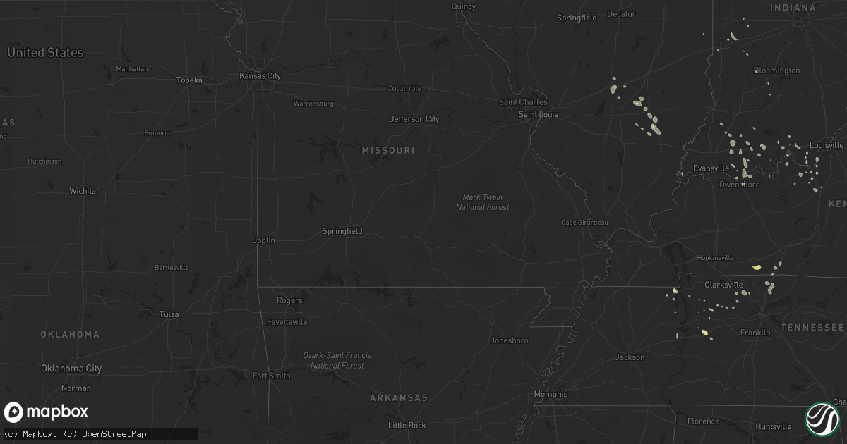
Hail Map in Tennessee on August 23, 2014
Get this storm
August 23 map
$229
one time, instant access
Download today. No call, no setup
Keep the $229
Bought the map and want the full workflow? Apply the entire $229 to a subscription within 7 days. None of it is wasted.
Every map, not just this one
This buys you this map. Subscription and you get every map we run, in the markets you choose from a few cities to whole states to nationwide. Plus real-time alerts the moment a storm fires.
Contact data
Name, contact info, occupancy, even credit band for addresses in the footprint. You go from where it hit to who to call.
Become the source they trust
Unlimited branding weather history reports on demand. You already have the documented answer ready for the property owner, and you are the one who showed up with it.
Property data and RoofTrace estimates
Pull up any address you have got, its value and the exact code rules for that jurisdiction, straight from One Click Code. Then RoofTrace estimates the squares, pitch, and roof value, priced the way you price.
Storm reports in Tennessee
Tennessee
| Date | Description |
|---|---|
| 08/23/20145:28 PM CDT | 60 ft trees reported down. |
| 08/23/20145:15 PM CDT | Ham operator reported roof damage to a building on the square in centerville. |
| 08/23/20145:15 PM CDT | Numerous large trees and branches were downed at brentridge apartments on bell rd. A stop sign was also snapped in half. A community flag pole was bent also with a lot |
| 08/23/20144:52 PM CDT | Trees and power lines are down in hendersonville. |
| 08/23/20143:39 PM CDT | Emergency management reported a frew trees down on heads church rd. |
| 08/23/20143:30 PM CDT | Emergency management reported a few trees down on heads church rd. Also in the cedar hill to coopertown area for generally a two to three mile stretch...two to three to |
| 08/23/20143:10 PM CDT | Trees and power lines were down in pleasant view near the goss rd area. A roof also received damage. |
All States Impacted by Hail Map on August 23, 2014
Cities Impacted by Hail Map on August 23, 2014
- White River, SD
- Lafayette, CO
- Louisville, CO
- Pipestone, MN
- Ruthton, MN
- Inverness, FL
- Wauneta, NE
- Palisade, NE
- Benkelman, NE
- Louisville, KY
- Elizabeth, IN
- Arcadia, NE
- Russellville, KY
- Adairville, KY
- Yankton, SD
- Mission Hill, SD
- Viborg, SD
- Irene, SD
- Hurley, SD
- Volin, SD
- Stockport, IA
- Yuma, CO
- Otis, CO
- Benson, MN
- Kimball, SD
- Vandalia, IL
- Trent, SD
- Burke, SD
- Platte, SD
- Anamosa, IA
- McEwen, TN
- Only, TN
- Stendal, IN
- Oakland City, IN
- Winslow, IN
- Fairfax, SD
- Corsica, SD
- Lake Andes, SD
- Armour, SD
- Spencer, NE
- Mount Vernon, SD
- Stickney, SD
- Geddes, SD
- Kingston Mines, IL
- Manito, IL
- Glasford, IL
- Mapleton, IL
- Ord, NE
- Pleasant View, TN
- Milltown, IN
- Leavenworth, IN
- Wakonda, SD
- Stewart, TN
- Chappell, NE
- Oshkosh, NE
- Erin, TN
- Old Town, FL
- Ashland City, TN
- Chapmansboro, TN
- Erie, CO
- Mount Vernon, IN
- Atkinson, NE
- Avon, MN
- Dumont, MN
- Ramsey, IL
- Atalissa, IA
- West Liberty, IA
- Wood, SD
- Shobonier, IL
- Alma, IL
- Starbuck, MN
- Elizabethtown, KY
- Rineyville, KY
- Elkton, SD
- Dale, IN
- Ferdinand, IN
- Laconia, IN
- Guttenberg, IA
- Garnavillo, IA
- Tyndall, SD
- Taylor Ridge, IL
- Illinois City, IL
- Terre Haute, IN
- Bridgeport, NE
- Birdseye, IN
- Bristow, IN
- Rushville, NE
- Hay Springs, NE
- Buchanan, TN
- Ekron, KY
- Brandenburg, KY
- Madison, SD
- Plainview, NE
- Pierce, NE
- Toulon, IL
- Greencastle, IN
- San Mateo, FL
- Dunlap, IL
- Osage, IA
- Osakis, MN
- Cairo, NE
- Montrose, SD
- Nunnelly, TN
- Saint Edward, NE
- Springville, TN
- Cisne, IL
- Geff, IL
- Ethan, SD
- Gainesville, FL
- Alachua, FL
- Vine Grove, KY
- Lena, IL
- Dunnellon, FL
- Ocala, FL
- Hendersonville, TN
- Cottontown, TN
- Portland, TN
- White House, TN
- New Middletown, IN
- Corydon, IN
- Velpen, IN
- Fairfield, IA
- Pekin, IL
- Bonesteel, SD
- Bedford, IN
- Haigler, NE
- Parks, NE
- Mills, NE
- Kinmundy, IL
- Xenia, IL
- Broadwater, NE
- Gentryville, IN
- Parker, SD
- Richland, IN
- Milan, IL
- Sherrard, IL
- Aledo, IL
- Reynolds, IL
- Fort Lupton, CO
- Brighton, CO
- Saint Cloud, MN
- Saint Joseph, MN
- Saint Paul, NE
- Williston, FL
- Archer, FL
- Scotia, NE
- Greeley, NE
- Keenesburg, CO
- Cross Plains, TN
- Petersburg, IN
- White Springs, FL
- Freeport, IL
- De Smet, SD
- Carthage, SD
- Owensboro, KY
- Akron, CO
- Brownstown, IL
- Walcott, IA
- Blue Grass, IA
- Stockton, IA
- Vermillion, SD
- Gayville, SD
- Dannebrog, NE
- Olmstead, KY
- West Point, KY
- Guston, KY
- Charlotte, TN
- Naper, NE
- Altenburg, MO
- Jackson, MO
- Franklin, KY
- Holladay, TN
- Rockville, IN
- Rinard, IL
- Gibbon, NE
- Chamberlain, SD
- Saint Meinrad, IN
- West Point, NE
- Parkston, SD
- Kearney, NE
- Lewisport, KY
- Maceo, KY
- Wellfleet, NE
- Stuart, NE
- Louisville, IL
- Flora, IL
- Rockwell, IA
- Nunda, SD
- Arlington, SD
- Ramona, SD
- Morriston, FL
- Lynnville, IN
- Boonville, IN
- Mason City, IA
- Culbertson, NE
- Hayes Center, NE
- Batavia, IA
- Oakville, IA
- Park Ridge, IL
- Chicago, IL
- English, IN
- Birmingham, IA
- Perryville, MO
- Neligh, NE
- Adams, TN
- Paris, TN
- Huron, SD
- Ravenna, NE
- Sims, IL
- Hudson, CO
- Paris, IL
- Palatine, IL
- Rolling Meadows, IL
- Arlington Heights, IL
- Brazil, IN
- Tennyson, IN
- Rockport, IN
- Grandview, IN
- Chrisney, IN
- Battletown, KY
- Letcher, SD
- Bloomfield, IN
- Centerpoint, IN
- Bayard, NE
- Edgemont, SD
- Davis, SD
- Floral City, FL
- Chadron, NE
- Pukwana, SD
- Princeville, IL
- Brimfield, IL
- Flandreau, SD
- Edgewood, IL
- Farina, IL
- Albion, NE
- North Loup, NE
- Oelrichs, SD
- Waverly, TN
- Cedar Hill, TN
- Parkton, NC
- Saint Pauls, NC
- Rosedale, IN
- Muldraugh, KY
- Elmwood, IL
- Spencer, SD
- Cold Spring, MN
- Springfield, TN
- New Boston, IL
- Freeman, SD
- Marion, SD
- Payneville, KY
- Rhodelia, KY
- Bowling Green, IN
- Reddick, FL
- Trivoli, IL
- Scotland, SD
- Elgin, NE
- Oakdale, NE
- Mitchell, SD
- Tennessee Ridge, TN
- Herman, MN
- La Crosse, IN
- San Pierre, IN
- Lamar, IN
- Fullerton, NE
- Keenes, IL
- Tell City, IN
- Stockton, IL
- Irvington, KY
- Custer, KY
- Fairfield, IL
- Hillsboro, IA
- Lone Tree, IA
- Nichols, IA
- Tremont, IL
- Green Valley, IL
- Bloomington, IN
- Springville, IN
- Crofton, NE
- Lennox, SD
- Chancellor, SD
- Huntingburg, IN
- Burlington, IA
- Palmer, NE
- Woodburn, KY
- Bowling Green, KY
- Marengo, IN
- Leola, SD
- Salem, SD
- Vanleer, TN
- Dickson, TN
- Cedar Rapids, NE
- Belgrade, NE
- Hurricane Mills, TN
- Iuka, IL
- Osmond, NE
- Cannelton, IN
- Big Sandy, TN
- Sartell, MN
- Rice, MN
- Loup City, NE
- Canistota, SD
- Bridgewater, SD
- La Fayette, IL
- West Burlington, IA
- Gladstone, IL
- Biggsville, IL
- Radcliff, KY
- Saint Libory, NE
- Fort Knox, KY
- Bassett, NE
- Newport, NE
- Clarksville, TN
- Cumberland Furnace, TN
- Dubois, IN
- Jasper, IN
- Volga, SD


