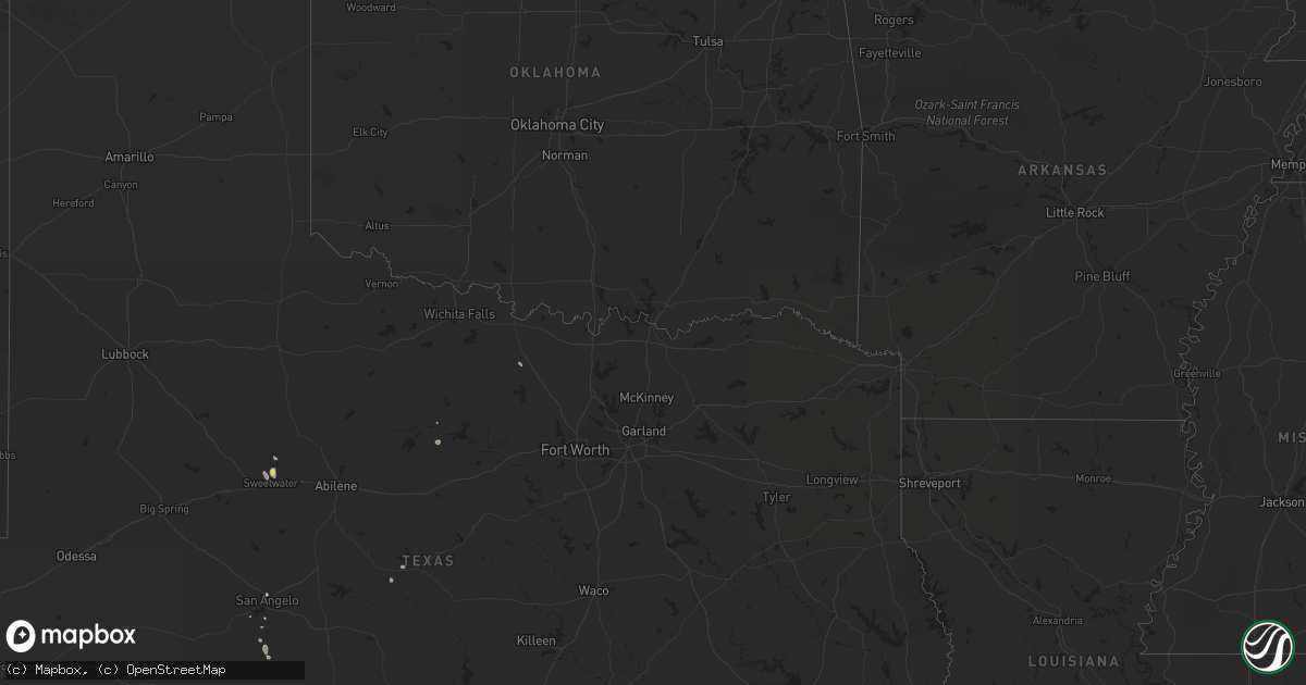
Hail Map in Texas on August 23, 2013
Get this storm
August 23 map
$229
one time, instant access
Download today. No call, no setup
Keep the $229
Bought the map and want the full workflow? Apply the entire $229 to a subscription within 7 days. None of it is wasted.
Every map, not just this one
This buys you this map. Subscription and you get every map we run, in the markets you choose from a few cities to whole states to nationwide. Plus real-time alerts the moment a storm fires.
Contact data
Name, contact info, occupancy, even credit band for addresses in the footprint. You go from where it hit to who to call.
Become the source they trust
Unlimited branding weather history reports on demand. You already have the documented answer ready for the property owner, and you are the one who showed up with it.
Property data and RoofTrace estimates
Pull up any address you have got, its value and the exact code rules for that jurisdiction, straight from One Click Code. Then RoofTrace estimates the squares, pitch, and roof value, priced the way you price.
Storm reports in Texas
Texas
| Date | Description |
|---|---|
| 08/23/20135:05 PM CDT | *** 1 fatal *** winds blew roof off of barn ne of anna. Two occupants inside...one fatality. |
| 08/23/20134:25 PM CDT | 2 power poles snapped due to high winds near lake amon carter |
| 08/23/20133:45 PM CDT | Numerous masquite tree limbs between 1-2 feet in diameter were downed. |
| 08/23/20133:45 PM CDT | Numerous mesquite tree limbs up to 1 foot in diameter were downed in foster park. |
| 08/22/20137:30 PM CDT | A microburst occurred over roby at approximately 730 pm. Two large south-facing windows at the roby city hall were blown in and several trees were uprooted within city |
All States Impacted by Hail Map on August 23, 2013
Cities Impacted by Hail Map on August 23, 2013
- Brownwood, TX
- Christoval, TX
- Burkeville, VA
- Rice, VA
- Crewe, VA
- Henderson, CO
- Brighton, CO
- Commerce City, CO
- Las Vegas, NV
- Jean, NV
- Sedalia, CO
- Littleton, CO
- Warfield, VA
- Campo, CA
- Soddy Daisy, TN
- Graysville, TN
- Zapata, TX
- Fountain Inn, SC
- Dade City, FL
- Zephyrhills, FL
- Crossville, TN
- Pikeville, TN
- Lewisburg, KY
- Russellville, KY
- Darlington, SC
- Alberta, VA
- Dundas, VA
- Blackstone, VA
- Green Bay, VA
- Meherrin, VA
- Sweetwater, TX
- San Angelo, TX
- Saint George, SC
- Princeton, KY
- Dawson Springs, KY
- Plant City, FL
- Lithia, FL
- Winder, GA
- Jefferson, GA
- Adairville, KY
- Springfield, TN
- Rangely, CO
- Woodburn, KY
- Bowling Green, KY
- Battleboro, NC
- Rocky Mount, NC
- Winter Garden, FL
- Davisboro, GA
- Harrison, GA
- Bartow, GA
- Whiteville, NC
- Elkton, KY
- Newberry Springs, CA
- Gateway, CO
- Steamboat Springs, CO
- Bozeman, MT
- Tryon, NC
- Mill Spring, NC
- Columbus, NC
- Cairo, IL
- Reevesville, SC
- Tererro, NM
- Tecopa, CA
- Raeford, NC
- Fayetteville, NC
- Parkton, NC
- Lumber Bridge, NC
- Sale Creek, TN
- Sevierville, TN
- Pine Valley, CA
- Boulevard, CA
- Lakeland, FL
- Saint Charles, KY
- Nortonville, KY
- Alvaton, KY
- Green River, UT
- Dillon, MT
- Groveland, FL
- Dorchester, SC
- Hudson, CO
- Honea Path, SC
- Congress, AZ
- Branchville, VA
- Thompsons Station, TN
- Emporia, VA
- Skippers, VA
- De Beque, CO
- Simpsonville, SC
- Piedmont, SC
- Pelzer, SC
- Graham, TX
- Dinosaur, CO
- Evergreen, CO
- Moss, TN
- Tennille, GA
- Wrightsville, GA
- Kathleen, FL
- Phenix City, AL
- Victoria, VA
- Red Boiling Springs, TN
- Bangs, TX
- Macon, GA
- Winkelman, AZ
- Indian Mound, TN
- Palmersville, TN
- Opelika, AL
- Clermont, FL
- Sparta, TN
- Ocala, FL
- Flagstaff, AZ
- Eldorado, TX
- Dupont, CO
- Denver, CO
- Silverthorne, CO
- Fort Benning, GA
- Warner Robins, GA
- Sharon Grove, KY
- Winter Park, FL
- Summerfield, FL
- Evensville, TN
- Henderson, NV
- Breckenridge, TX
- Mountain Rest, SC
- Dunlap, TN
- Inglis, FL
- Sunset, TX
- Bowie, TX
- Glasgow, KY
- Belton, SC
- Lake Powell, UT
- Ridgeville, SC
- Summerville, SC
- Roby, TX
- Gainesboro, TN


