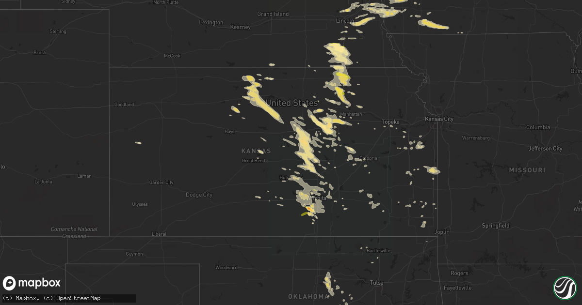
Hail Map in Kansas on August 22, 2015
Get this storm
August 22 map
$229
one time, instant access
Download today. No call, no setup
Keep the $229
Bought the map and want the full workflow? Apply the entire $229 to a subscription within 7 days. None of it is wasted.
Every map, not just this one
This buys you this map. Subscription and you get every map we run, in the markets you choose from a few cities to whole states to nationwide. Plus real-time alerts the moment a storm fires.
Contact data
Name, contact info, occupancy, even credit band for addresses in the footprint. You go from where it hit to who to call.
Become the source they trust
Unlimited branding weather history reports on demand. You already have the documented answer ready for the property owner, and you are the one who showed up with it.
Property data and RoofTrace estimates
Pull up any address you have got, its value and the exact code rules for that jurisdiction, straight from One Click Code. Then RoofTrace estimates the squares, pitch, and roof value, priced the way you price.
Storm reports in Kansas
Kansas
| Date | Description |
|---|---|
| 08/22/20158:25 AM CDT | Public report via facebook of quarter sized hail on the west side of valley center. Time is estimated from radar. |
| 08/22/20157:50 AM CDT | Trained spotter reporting golf ball sized hail with varying sizes covering the ground. |
| 08/22/20154:10 AM CDT | 2 foot diameter tree branch down |
| 08/22/20153:40 AM CDT | Large trees reported down in pittsburg. Winds were estimated at 60 mph. |
| 08/22/20153:25 AM CDT | Large trees downed in girard ks. Large trees were also reported down across mutiple locations across crawford county when the line of storms passed through. |
| 08/22/201512:21 AM CDT | A local report indicates 60 MPH wind near SALINA AIRPORT |
| 08/21/201511:41 PM CDT | A local report indicates 1.00 inch wind near 7 N MOUNDRIDGE |
| 08/21/201511:28 PM CDT | A local report indicates 62 MPH wind near CANTON |
| 08/21/201511:24 PM CDT | A local report indicates 1.00 inch wind near CANTON |
| 08/21/201510:50 PM CDT | 16 power poles snapped from the east side of abilene to 2 miles east of abilene |
| 08/21/201510:36 PM CDT | 65 mph winds also reported.the ground is covered with hail relayed via saline co. Emergency management. |
| 08/21/201510:01 PM CDT | Pea sized hail was also reported. |
| 08/21/20158:38 PM CDT | A local report indicates 1.00 inch wind near 8 S BARNES |
| 08/21/20158:04 PM CDT | A local report indicates 1.00 inch wind near MARYSVILLE |
| 08/21/20157:34 PM CDT | A local report indicates 1.00 inch wind near HANOVER |
All States Impacted by Hail Map on August 22, 2015
Cities Impacted by Hail Map on August 22, 2015
- Bisbee, AZ
- Myrtle, MS
- Bowie, AZ
- Frankfort, KS
- Olsburg, KS
- Westmoreland, KS
- Elmwood, NE
- Palmyra, NE
- Unadilla, NE
- Weeping Water, NE
- Walton, NE
- Eagle, NE
- Avoca, NE
- De Witt, NE
- Vincent, AL
- Stephen, MN
- Mcalester, OK
- Stuart, OK
- Eudora, AR
- Deerwood, MN
- Garrison, MN
- Aitkin, MN
- Jesup, GA
- Michie, TN
- Cochise, AZ
- Clay Center, KS
- Bedford, IA
- Papillion, NE
- Springfield, NE
- Lucas, KS
- Tipton, KS
- Barnard, KS
- Sylvan Grove, KS
- Beloit, KS
- Osborne, KS
- Hunter, KS
- Wamego, KS
- Saint George, KS
- Claflin, KS
- Water Valley, MS
- Barnes, KS
- Waterville, KS
- Randolph, KS
- Greenleaf, KS
- Linn, KS
- Stillwater, OK
- Town Creek, AL
- Estill Springs, TN
- Tullahoma, TN
- Decherd, TN
- Winchester, TN
- Ashland, NE
- Bremen, KS
- Marysville, KS
- New Market, IA
- Blockton, IA
- Gravity, IA
- Lockwood, MO
- Columbus, KS
- Scammon, KS
- Chapman, KS
- Abilene, KS
- Athens, AL
- Woodbine, IA
- Beatrice, NE
- Jansen, NE
- Woodbine, KS
- Fort Riley, KS
- Talmage, KS
- Wakefield, KS
- Enterprise, KS
- Longford, KS
- Junction City, KS
- Minneapolis, KS
- Solomon, KS
- Milford, KS
- Elfrida, AZ
- Ripley, OK
- Viola, KS
- Clearwater, KS
- Minnesota Lake, MN
- Wells, MN
- Waldorf, MN
- Cottage Grove, MN
- Ochelata, OK
- Burchard, NE
- Zumbrota, MN
- Goodhue, MN
- Montrose, AR
- Tryon, OK
- Morrison, OK
- Perry, OK
- Perkins, OK
- Wilmot, AR
- Plattsmouth, NE
- Cedar, KS
- Portis, KS
- Gaylord, KS
- Lincoln, KS
- Alton, KS
- Downs, KS
- Smith Center, KS
- Athol, KS
- Kensington, KS
- Medford, MN
- Faribault, MN
- River Falls, WI
- Ida Grove, IA
- Battle Creek, IA
- Wellington, KS
- Kanopolis, KS
- Ellsworth, KS
- Leighton, AL
- Hillsboro, AL
- Courtland, AL
- Muscle Shoals, AL
- Killen, AL
- Rogersville, AL
- Tombstone, AZ
- Stroud, OK
- Depew, OK
- Edgerton, KS
- Gardner, KS
- Newfolden, MN
- Benton, KS
- Towanda, KS
- Potwin, KS
- Whitewater, KS
- Atlanta, KS
- Lynnville, TN
- Mount Pleasant, TN
- Summertown, TN
- Treynor, IA
- Okemah, OK
- Hoisington, KS
- Berryton, KS
- Carthage, MO
- Hortense, GA
- Clare, IA
- Fort Ripley, MN
- Brainerd, MN
- Titonka, IA
- Bancroft, IA
- Lufkin, TX
- Diboll, TX
- Clatonia, NE
- Cortland, NE
- Magnolia, TX
- Zimmerman, MN
- Princeton, MN
- Nemaha, IA
- Newell, IA
- Santa Clara, NM
- White Castle, LA
- Huntsville, AL
- Isanti, MN
- Cambridge, MN
- New Richmond, WI
- Hudson, WI
- Hammond, WI
- Hastings, MN
- Roberts, WI
- Clyde, KS
- Lewisburg, TN
- Belfast, TN
- Petersburg, TN
- Pocahontas, IA
- Fonda, IA
- Lambert, MS
- Macedonia, IA
- Silver City, IA
- Henderson, IA
- Carson, IA
- Underwood, IA
- Ceresco, NE
- Lincoln, NE
- Davey, NE
- Dickens, IA
- Plainville, KS
- Walhalla, ND
- Mankato, KS
- Esbon, KS
- Martell, NE
- Roca, NE
- Hickman, NE
- Moundridge, KS
- Schaller, IA
- Courtland, MS
- Marks, MS
- Batesville, MS
- Odell, NE
- Diller, NE
- Hollenberg, KS
- Blue Rapids, KS
- Hanover, KS
- Townsend, GA
- Loganville, GA
- Monroe, GA
- Winterset, IA
- Macksburg, IA
- Orient, IA
- Conway Springs, KS
- Haysville, KS
- Peck, KS
- Milton, ND
- Osnabrock, ND
- Mcpherson, KS
- Hesston, KS
- Galva, KS
- Gilmore City, IA
- Elkhorn, NE
- Omaha, NE
- Fort Calhoun, NE
- Blair, NE
- Bennington, NE
- Missouri Valley, IA
- Kennard, NE
- Dawson, GA
- Assaria, KS
- Silver City, NM
- Jasper, FL
- Golden City, MO
- South Greenfield, MO
- Greenfield, MO
- Lamar, MO
- Schell City, MO
- Cumming, GA
- Alpharetta, GA
- Welda, KS
- Kincaid, KS
- Scarville, IA
- Bricelyn, MN
- Alden, MN
- Emmons, MN
- Kiester, MN
- Strandquist, MN
- Karlstad, MN
- Russellville, AL
- Leoti, KS
- Herington, KS
- Fredonia, KS
- Rome, GA
- Vian, OK
- Cookson, OK
- Park Hill, OK
- Wellsville, KS
- Paola, KS
- Willcox, AZ
- Langdon, ND
- Natoma, KS
- Turon, KS
- Pratt, KS
- Green Valley, AZ
- Kenyon, MN
- West Concord, MN
- Brunswick, GA
- Cottonwood Falls, KS
- Strong City, KS
- Emporia, KS
- Council Bluffs, IA
- McClelland, IA
- Pacific Junction, IA
- Wilsey, KS
- Council Grove, KS
- Benson, AZ
- Saint David, AZ
- Sauk Rapids, MN
- Logan, IA
- Guide Rock, NE
- Elk River, MN
- Woodston, KS
- Cavalier, ND
- Live Oak, FL
- Wellborn, FL
- Narka, KS
- Garden Plain, KS
- Andale, KS
- Mount Hope, KS
- Cheney, KS
- Colwich, KS
- Goddard, KS
- Wayzata, MN
- Long Lake, MN
- Liberal, MO
- Tescott, KS
- Falun, KS
- Canton, KS
- Lindsborg, KS
- Salina, KS
- Roxbury, KS
- Palmer, IA
- Oakland, MS
- Pope, MS
- Overbrook, KS
- Baldwin City, KS
- Alachua, FL
- Barnsdall, OK
- Northwood, IA
- Savannah, GA
- Box Springs, GA
- Stanchfield, MN
- Dalbo, MN
- Andover, KS
- Augusta, KS
- Glenwood, IA
- Tabor, IA
- Ramer, TN
- Counce, TN
- Corinth, MS
- Guys, TN
- Weleetka, OK
- Crescent, IA
- Red Oak, IA
- Essex, IA
- Walnut, KS
- Pleasanton, KS
- Mound City, KS
- Richland, GA
- Preston, GA
- Weston, GA
- Joplin, MO
- Green, KS
- Leonardville, KS
- Odebolt, IA
- Prague, OK
- Girard, KS
- Helena, AL
- Malvern, IA
- Wichita, KS
- Rockville, MO
- Jasper, MO
- Rolfe, IA
- Bradgate, IA
- Centerville, KS
- Parker, KS
- Foster, MO
- Prescott, KS
- Enid, MS
- Clear Lake, WI
- Elliott, IA
- Rantoul, KS
- Ottawa, KS
- Calvin, OK
- Fort Davis, TX
- New Richland, MN
- Almyra, AR
- Groveoak, AL
- Guntersville, AL
- Langston, AL
- Center City, MN
- Dunnellon, FL
- White City, KS
- Sterling, KS
- Screven, GA
- Patterson, GA
- Camden, AR
- Riley, KS
- Foley, MN
- Nehawka, NE
- Bennet, NE
- Syracuse, NE
- Reeds, MO
- Prairieville, LA
- Denham Springs, LA
- Luck, WI
- Cushing, WI
- Howard, KS
- Longton, KS
- Fall River, KS
- Lost Springs, KS
- Lockesburg, AR
- Miltonvale, KS
- Aurora, KS
- Delphos, KS
- Punta Gorda, FL
- Tucson, AZ
- Hillsboro, KS
- Marquette, KS
- Gypsum, KS
- Lehigh, KS
- Newton, KS
- Leon, KS
- Maize, KS
- Mulvane, KS
- Derby, KS
- Halstead, KS
- Hutchinson, KS
- Burrton, KS
- Belle Plaine, KS
- Mcconnell Afb, KS
- Sedgwick, KS
- Valley Center, KS
- Bentley, KS
- Haven, KS
- South Hutchinson, KS
- Hallam, NE
- Hopkins, MN
- Minneapolis, MN
- Lawrence, KS
- Forest City, IA
- Leland, IA
- Hinesville, GA
- Farmington, MN
- Charter Oak, IA
- Schleswig, IA
- Geismar, LA
- Gonzales, LA
- Saint Amant, LA
- Clifton, AZ
- Glencoe, OK
- Paradise, KS
- Woden, IA
- Britt, IA
- Campbell, MN
- Thurman, IA
- Murray, NE
- Hastings, IA
- Louisville, NE
- Clarinda, IA
- Nodaway, IA
- Hume, MO
- Richards, MO
- Rich Hill, MO
- Oak Park, MN
- Morriston, FL
- Waseca, MN
- Tanner, AL
- Moorhead, IA
- Stockton, KS
- Saint Helena Island, SC
- Brookville, KS
- Fulton, KS
- Cannon Falls, MN
- Dennison, MN
- Mount Lemmon, AZ
- Portland, AR
- Lula, GA
- Gillsville, GA
- Summerfield, FL
- Plymouth, NE
- Inman, KS
- New Cambria, KS
- Huachuca City, AZ
- Waverly, GA
- Lu Verne, IA
- Pawhuska, OK
- Auburn, GA
- Parkdale, AR
- Deming, NM
- Benton, IA
- Saint Paul, MN
- Alsen, ND
- Mulberry, KS
- Arma, KS
- Hillman, MN
- Pierz, MN
- Dunlap, IA
- Winthrop, AR
- Jolley, IA
- Eureka, KS
- Severy, KS
- Alta, IA
- Patagonia, AZ
- Anoka, MN
- Hurley, NM
- Lyerly, GA
- Summerville, GA
- Foreston, MN
- Pickrell, NE
- Blue Springs, NE
- Wymore, NE
- Western, NE
- Swanton, NE
- Churchs Ferry, ND
- Early, IA
- Lawrenceville, GA
- Dacula, GA
- Conway, MO
- Lebanon, MO
- Phillipsburg, MO
- Randolph, IA
- Waverly, NE
- Ithaca, NE
- Memphis, NE
- Gretna, NE
- Raymond, NE
- Bellevue, NE
- Union, NE
- Greenwood, NE
- South Bend, NE
- Partridge, KS
- Emerson, IA
- Iuka, KS
- San Carlos, AZ
- Florien, LA
- Goodwater, AL
- Pisgah, IA
- Hill City, MN
- Swatara, MN
- Moran, KS
- Wetumka, OK
- Everton, MO
- Stacy, MN
- North Branch, MN
- Castle, OK
- Boley, OK
- Durham, KS
- Inver Grove Heights, MN
- South Saint Paul, MN
- Tupelo, MS
- Silver Springs, FL
- Eden Prairie, MN
- Owatonna, MN
- Chanute, KS
- Culleoka, TN
- Shelbyville, TN
- Cornersville, TN
- Ethridge, TN
- Somers, IA
- Moorland, IA
- Breckenridge, MN
- Afton, MN
- Audubon, IA
- Kimballton, IA
- Houlton, WI
- Somerset, WI
- Richmond Hill, GA
- Ramona, KS
- Hope, KS
- Fairdale, ND
- Chandler, OK
- Davenport, OK
- Kellerton, IA
- Red Cloud, NE
- Apple Springs, TX
- Naples, FL
- Cushing, OK
- Miami, OK
- Labelle, FL
- Texarkana, AR
- Greenbush, MN
- Falcon, MO
- Ellendale, MN
- Atlantic, IA
- Arcadia, FL
- Murdock, NE
- Alvo, NE
- Ogden, KS
- Manhattan, KS
- Sylacauga, AL
- Viking, MN
- Bennington, KS
- Lorimor, IA
- Littlefield, AZ
- Kanawha, IA
- Dawsonville, GA
- Gainesville, GA
- Saint Paul, KS
- Galesburg, KS
- Erie, KS
- Peabody, KS
- Mondamin, IA
- Cunningham, KS
- Sturgeon Lake, MN
- Willow River, MN
- Orange, TX
- Tampa, KS
- Saint Francis, MN
- Modale, IA
- Green City, MO
- Immokalee, FL
- Danbury, IA
- Becker, MN
- Lake Panasoffkee, FL
- Wildwood, FL
- Grand Rapids, MN
- Dustin, OK
- Elmdale, KS
- Silver Creek, GA
- Lindale, GA
- Harris, MN
- Buhler, KS
- Honey Creek, IA
- Auburn, KS
- Topeka, KS
- Onawa, IA
- Blencoe, IA
- De Queen, AR
- Williston, FL
- Kingman, KS
- New Hope, AL
- Adams, NE
- Firth, NE
- Siren, WI
- Badger, MN
- Ruthven, IA
- Neola, IA
- Harveyville, KS
- Tuscumbia, AL
- Saint Paul Park, MN
- Appleton City, MO
- Butler, MO
- Corning, IA
- Nerstrand, MN
- Sandstone, MN
- Thompson, IA
- Drumright, OK
- Suwanee, GA
- Duluth, GA
- Wesley, IA
- Algona, IA
- Soldier, IA
- Ute, IA
- Dow City, IA
- Alma, KS
- Gaylesville, AL
- Browerville, MN
- Hickory Flat, MS
- Potts Camp, MS
- New Albany, MS
- Long Lane, MO
- Elkland, MO
- Northfield, MN
- Dundas, MN
- Pell City, AL
- Huntington, TX
- Lebanon, KS
- Marion, KS
- Carl Junction, MO
- Webb City, MO
- Hartland, MN
- Olpe, KS
- Bayard, NM
- Lytton, IA
- Hilton Head Island, SC
- Farlington, KS
- Marathon, TX
- Felton, MN
- Mount Ayr, IA
- Shafer, MN
- Inverness, FL
- Lecanto, FL
- Hernando, FL
- Albert City, IA
- Argyle, MN
- Canton, GA
- Buffalo Center, IA
- Saint Charles, IA
- San Simon, AZ
- Quenemo, KS
- Hoboken, GA
- Garnett, KS
- McCune, KS
- Douglas, NE
- Minnetonka, MN
- Pomona, KS
- Villisca, IA
- Redding, IA
- Washington, KS
- Ottosen, IA
- New Edinburg, AR
- Jackson, LA
- Ethel, LA
- Harwood, ND
- Albert Lea, MN
- Clarks Grove, MN
- Paris, MS
- Oxford, MS
- Alta Vista, KS
- Clermont, GA
- Kimberly, AL
- Gardendale, AL
- Warrior, AL
- Lindstrom, MN
- Chisago City, MN
- Walton, KS
- Beverly, KS
- Little Sioux, IA
- Moundville, MO
- Murrayville, GA
- Dahlonega, GA
- East Grand Forks, MN
- Sterrett, AL
- Harlan, IA
- Devils Lake, ND
- Webster, ND
- Pooler, GA
- Vandiver, AL
- Filley, NE
- Palmer, KS
- Fairbury, NE
- Endicott, NE
- Barneston, NE
- Steele City, NE
- Daykin, NE
- Morrowville, KS
- Great Bend, KS
- Madison, KS
- Mineola, IA
- Minden, IA
- Carter Lake, IA
- Valley, NE
- Arlington, NE
- Boys Town, NE
- Clear Lake, MN
- Hubbell, NE
- Dermott, AR
- Madison, AL
- Florence, KS
- Waycross, GA
- Sterling, NE
- Wilson, KS
- Dorrance, KS


