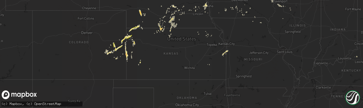
Hail Map in Kansas on August 22, 2014
The weather event in Kansas on August 22, 2014 includes Hail map. 17 states and 298 cities were impacted and suffered possible damage. The total estimated number of properties impacted is 599.
Want more than just the map?
Turn this storm into a full workflow.
- Owner + property data so you know who to knock
- OnDemand branded weather history reports to win the "did we even have hail?" argument
- RoofTrace estimate so reps stop guessing numbers at the door
Bought this map? Upgrade within 7 days and we'll credit the $230. (10-15 min setup call)
Hail
599
Estimated number of impacted properties by a 1.00" hail or larger19
Estimated number of impacted properties by a 1.75" hail or larger0
Estimated number of impacted properties by a 2.50" hail or largerStorm reports in Kansas
Kansas
| Date | Description |
|---|---|
| 08/22/20146:55 PM CDT | Semi blown over just west of brewster on interstate 70. Time estimated via radar. |
| 08/22/20146:45 PM CDT | A small shop had some roof damage and part of a brick wall blown in. Large trees were also blown down in town. |
| 08/22/20146:45 PM CDT | A local report indicates 60 MPH wind near 7 S ELLIS |
| 08/22/20146:44 PM CDT | A local report indicates 70 MPH wind near 5 S ELLIS |
| 08/22/20146:40 PM CDT | Powerpoles were reported down on grants villa road |
| 08/22/20146:40 PM CDT | Powerlines were reported down in the vicinity of butterfield trail road and ellis avenue |
| 08/22/20146:35 PM CDT | The top of a small barn blew off from estimated greater than 60 mph thunderstorm gust. |
| 08/22/20146:32 PM CDT | Semi blown over on interstate 70 at mile marker 86. |
| 08/22/20146:32 PM CDT | 60 to 70 mph winds estimated. |
| 08/22/20146:30 PM CDT | A local report indicates 60 MPH wind near 3 ENE FRIZELL |
| 08/22/20146:30 PM CDT | Winds blew out windows of residence. |
| 08/22/20146:21 PM CDT | A local report indicates 60 MPH wind near 4 E OAKLEY |
| 08/22/20146:17 PM CDT | A local report indicates 1.00 inch wind near 12 N GOODLAND |
| 08/22/20146:16 PM CDT | Power is out and 5-6 inch diameter tree limbs down. |
| 08/22/20146:14 PM CDT | Numerous reports of trees and powerlines down in this area. |
| 08/22/20146:12 PM CDT | Numerous trees and powerlines reported down. Power reported out in the area of 327th and beaver creek rd. |
| 08/22/20146:10 PM CDT | Delayed report. Multiple telephone poles snapped at base along metcalf road between 303rd and 327th streets. As of 830 pm cdt this evening...metcalf road remains closed |
| 08/22/20146:05 PM CDT | Also blowing dust with near zero visibility |
| 08/22/20146:03 PM CDT | Power lines down near 311th street and hwy 69. |
| 08/22/20146:00 PM CDT | A local report indicates 1.25 inch wind near 12 NNE RULETON |
| 08/22/20145:57 PM CDT | Emergency manager reports multiple power lines down on u.s. Highway 50. Time is based on report of wind gust in proximity. |
| 08/22/20145:55 PM CDT | Nickel to quarter size hail. |
| 08/22/20145:53 PM CDT | A local report indicates 62 MPH wind near 8 SE SHARON SPRINGS |
| 08/22/20145:48 PM CDT | A local report indicates 1.75 inch wind near 13 NNW PHILLIPSBURG |
| 08/22/20145:48 PM CDT | Visibility down to 1/8th mile from dust. Power briefly went out just before winds hit. Small limbs down in yard. |
| 08/22/20145:41 PM CDT | A local report indicates 60 MPH wind near 11 NNE RULETON |
| 08/22/20145:40 PM CDT | A local report indicates 60 MPH wind near 2 W GRAY |
| 08/22/20145:25 PM CDT | Tractor trailer blown over on k-61. |
| 08/22/20145:20 PM CDT | A local report indicates 67 MPH wind near SCOTT CITY |
| 08/22/20145:15 PM CDT | Mostly dime size with a few quarter size hailstones. |
| 08/22/20145:11 PM CDT | Picnic table and two motorcycles overturned. |
| 08/22/20145:09 PM CDT | A local report indicates 60 MPH wind near 8 NNW SPEARVILLE |
| 08/22/20144:55 PM CDT | A local report indicates 65 MPH wind near FRIEND |
| 08/22/20144:50 PM CDT | The gust was measured from a davis weather instrument |
| 08/22/20144:48 PM CDT | Mostly nickels/dimes but a few quarters mixed in |
| 08/22/20144:26 PM CDT | A local report indicates 60 MPH wind near 4 ENE DEERFIELD |
| 08/22/20141:32 PM CDT | A local report indicates 63 MPH wind near COFFEY COUNTY AIRPORT |
| 08/22/201411:30 AM CDT | Very brief strong gusty winds estimated upwards of 50 mph. 1 1/2 to 2 inch diameter tree limbs down from a 3-year old maple tree. |
| 08/21/20149:10 PM CDT | A local report indicates 60 MPH wind near GAYLORD |
| 08/21/20147:05 PM CDT | A 95 year old barn was destroyed with debris scattered 250 to 300 yards away. |
All States Impacted by Hail Map on August 22, 2014
Cities Impacted by Hail Map on August 22, 2014
- Gresham, NE
- Smith Center, KS
- Burlington, CO
- Pecos, TX
- Jerome, ID
- Wendell, ID
- Clarks, NE
- Aurora, NE
- Oxford, NE
- Devils Tower, WY
- Moorcroft, WY
- Purdum, NE
- Dunning, NE
- Long Island, KS
- Phillipsburg, KS
- Muscatine, IA
- Dickens, NE
- Wallace, NE
- Weston, WY
- Stratton, NE
- Newman Grove, NE
- Cheyenne Wells, CO
- Sheridan Lake, CO
- Norfolk, NE
- Rozet, WY
- Twin Falls, ID
- Gillette, WY
- Saint Francis, KS
- Fairfield, ID
- Hershey, NE
- Garland, NE
- Raymond, NE
- Valparaiso, NE
- Malcolm, NE
- Kit Carson, CO
- Rockville, NE
- Ravenna, NE
- Gooding, ID
- Stamford, NE
- Orleans, NE
- Prairie View, KS
- Alma, NE
- Weldon, IA
- Lohrville, IA
- Dodge, NE
- West Point, NE
- Holcomb, KS
- Marietta, IL
- Smithfield, IL
- Loomis, NE
- Bertrand, NE
- Wiley, CO
- Kanorado, KS
- Arlington, CO
- Karval, CO
- Paola, KS
- Lebanon, KS
- Tampa, FL
- Louisburg, KS
- Portis, KS
- Gorin, MO
- Rutledge, MO
- Matherville, IL
- Viola, IL
- Milan, IL
- Aledo, IL
- Reynolds, IL
- Sherrard, IL
- Murdock, NE
- Manley, NE
- Weeping Water, NE
- Louisville, NE
- Almena, KS
- Tribune, KS
- Wewahitchka, FL
- Arapahoe, CO
- Eads, CO
- Phillips, NE
- Chapman, NE
- Central City, NE
- Marquette, NE
- Corydon, IA
- Allerton, IA
- Peculiar, MO
- Cleveland, MO
- Freeman, MO
- Red Cloud, NE
- Guide Rock, NE
- Saint Paul, NE
- Omaha, NE
- Edson, KS
- Winona, KS
- Wayne, NE
- Pilger, NE
- Lorimor, IA
- Thayer, IA
- Ona, FL
- Sundance, WY
- Elba, NE
- Wildwood, FL
- Trenton, NE
- Flagler, CO
- Wood River, NE
- Grand Island, NE
- Alda, NE
- Palmer, NE
- Wisner, NE
- Winside, NE
- Ravenna, KY
- Irvine, KY
- Myakka City, FL
- Goodland, KS
- Afton, IA
- Pilot Rock, OR
- Pendleton, OR
- Tekamah, NE
- Otter, MT
- Creston, IA
- Saint Edward, NE
- Richfield, ID
- Brady, NE
- Filer, ID
- Boys Town, NE
- Ashton, NE
- Lenora, KS
- Atwood, KS
- Norton, KS
- Bennington, NE
- Inavale, NE
- Bladen, NE
- Ceresco, NE
- McDonald, KS
- Silver Creek, NE
- Chelsea, IA
- Hayes Center, NE
- Culbertson, NE
- Havensville, KS
- Corning, KS
- Syracuse, KS
- Hampton, NE
- Henderson, NE
- Toulon, IL
- Clay Center, NE
- Fairfield, NE
- Kaycee, WY
- Ashland, KY
- Fontana, KS
- Kearney, NE
- Riverdale, NE
- Newburgh, IN
- Boonville, IN
- Whiting, KS
- Netawaka, KS
- Lindsay, NE
- Republican City, NE
- Frankfort, KY
- Owenton, KY
- Bird City, KS
- Waterloo, NE
- Fort Calhoun, NE
- Elkhorn, NE
- Lakin, KS
- Holdrege, NE
- Wahoo, NE
- New Virginia, IA
- Osceola, IA
- Herndon, KS
- Hooper, NE
- Scribner, NE
- Hazard, NE
- Pleasanton, NE
- Blue Hill, NE
- Ayr, NE
- Minden, NE
- Holstein, NE
- Juniata, NE
- Hastings, NE
- Lawrence, NE
- Kenesaw, NE
- Campbell, NE
- Upland, NE
- Roseland, NE
- Wellfleet, NE
- Sergeant Bluff, IA
- Salix, IA
- Panama City, FL
- Oxford, FL
- The Villages, FL
- Harts, WV
- Ranger, WV
- Heartwell, NE
- Bonita Springs, FL
- Estero, FL
- Fort Myers, FL
- Gaylord, KS
- Hugo, CO
- Haswell, CO
- Cimarron, KS
- Lakeland, FL
- Plant City, FL
- Weston, NE
- Gretna, NE
- Papillion, NE
- La Vista, NE
- Springfield, NE
- Goff, KS
- Nehawka, NE
- Hartwick, IA
- Belle Plaine, IA
- Brainard, NE
- Lucas, IA
- Chariton, IA
- Essex, IA
- Clarinda, IA
- Inglis, FL
- Bronson, FL
- Soldier, KS
- Gainesville, FL
- Wilcox, NE
- Cambridge, IL
- Albia, IA
- Bagdad, KY
- Davenport, FL
- Intercession City, FL
- Kissimmee, FL
- Lyburn, WV
- Missouri Valley, IA
- Victor, IA
- Ladora, IA
- Marengo, IA
- Saint Libory, NE
- Drexel, MO
- Logan, IA
- Magnolia, IA
- Stratton, CO
- Bethune, CO
- Dugway, UT
- Staplehurst, NE
- Funk, NE
- Lecanto, FL
- Beverly Hills, FL
- Alton, KS
- Hooker, OK
- Prescott, IA
- Corning, IA
- Woodburn, IA
- Yates Center, KS
- Shelton, NE
- Bliss, ID
- Hagerman, ID
- Speer, IL
- Russell, IA
- Melrose, IA
- Plano, IA
- Wallace, KS
- Pleasureville, KY
- Derby, IA
- Janesville, IA
- Cedar Falls, IA
- La Cygne, KS
- Hulett, WY
- Seneca, KS
- Centralia, KS
- Circleville, KS
- Holton, KS
- Humeston, IA
- Pleasantville, IA
- Knoxville, IA
- Greentop, MO
- York, NE
- Bradshaw, NE
- Maywood, NE
- Mulberry, FL
- Parrish, FL
- Nichols, IA
- West Liberty, IA
- Atalissa, IA
- Blue Rapids, KS
- Spurlockville, WV
- Alkol, WV
- Branchland, WV
- Alpha, IL
- New Windsor, IL
- Mason City, NE
- Ansley, NE
- Oconto, NE
- Benkelman, NE
- Max, NE
- Waterville, KS
- Lynn Center, IL
- Woodhull, IL
- Farwell, NE
- Dannebrog, NE
- Truro, IA
- Mondamin, IA
- Virgil, KS
- Downing, MO
- Bloomfield, IA


