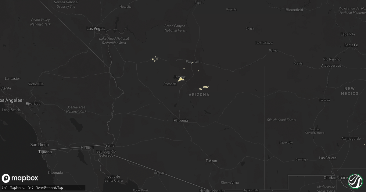
Hail Map in Arizona on August 21, 2020
Get this storm
August 21 map
$229
one time, instant access
Download today. No call, no setup
Keep the $229
Bought the map and want the full workflow? Apply the entire $229 to a subscription within 7 days. None of it is wasted.
Every map, not just this one
This buys you this map. Subscription and you get every map we run, in the markets you choose from a few cities to whole states to nationwide. Plus real-time alerts the moment a storm fires.
Contact data
Name, contact info, occupancy, even credit band for addresses in the footprint. You go from where it hit to who to call.
Become the source they trust
Unlimited branding weather history reports on demand. You already have the documented answer ready for the property owner, and you are the one who showed up with it.
Property data and RoofTrace estimates
Pull up any address you have got, its value and the exact code rules for that jurisdiction, straight from One Click Code. Then RoofTrace estimates the squares, pitch, and roof value, priced the way you price.
Storm reports in Arizona
Arizona
| Date | Description |
|---|---|
| 08/21/20206:34 PM CDT | Nickel sized hail... Strong winds and heavy rain. |
| 08/20/202011:46 PM CDT | At 445 PM MST, a severe thunderstorm was located near Cottonwood, or 15 miles northwest of Camp Verde, and is nearly stationary. HAZARD...60 mph wind gusts and quarter size hail. SOURCE...Radar indicated. This storm has a history of nickel size hail and strong winds. IMPACT...Hail damage to vehicles is expected. Expect wind damage to roofs, siding, and trees. Locations impacted include... Camp Verde, Prescott Valley, Clarkdale, Verde Village, Cherry, Yavapai County Fairgrounds, Bridgeport, Cottonwood, Middle Verde, Cornville, Jerome, Mingus Mountain Campground, Playground Group Campground, Potato Patch Campground, Tuzigoot National Monument, Dead Horse Ranch State Park and Powell Springs Campground. |
| 08/20/202011:38 PM CDT | At 438 PM MST, a severe thunderstorm was located 10 miles south of Clifton, moving south at 20 mph. HAZARD...60 mph wind gusts and quarter size hail. SOURCE...Radar indicated. IMPACT...Hail damage to vehicles is expected. Expect wind damage to roofs, siding, and trees. Locations impacted include... York, Three Way and Guthrie. This includes the following highways... Route 70 between mile markers 363 and 372, and between mile markers375 and 377. Route 75 between mile markers 383 and 398. Route 191 between mile markers 144 and 154. |
| 08/20/202011:19 PM CDT | At 419 PM MST, a severe thunderstorm was located 7 miles east of Yavapai County Fairgrounds, or 14 miles northeast of Prescott Valley, moving southwest at 10 mph. HAZARD...60 mph wind gusts and quarter size hail. SOURCE...Radar indicated. IMPACT...Hail damage to vehicles is expected. Expect wind damage to roofs, siding, and trees. Locations impacted include... Clarkdale, Verde Village, Cottonwood, Jerome, Mingus Mountain Campground, Playground Group Campground and Potato Patch Campground. |
All States Impacted by Hail Map on August 21, 2020
Cities Impacted by Hail Map on August 21, 2020
- Bark River, MI
- Carney, MI
- Little Lake, MI
- Stephenson, MI
- Daggett, MI
- Wilson, MI
- Perronville, MI
- Cornell, MI
- Toivola, MI
- Melrose, MN
- Freeport, MN
- Foster City, MI
- Palo Pinto, TX
- Humboldt, TN
- East Tawas, MI
- North Branch, MN
- Renwick, IA
- Prinsburg, MN
- Raymond, MN
- Seligman, AZ
- Atmore, AL
- Frisco City, AL
- Uriah, AL
- Elmore, MN
- Frost, MN
- Buffalo Center, IA
- Rake, IA
- Saint Peter, MN
- Mankato, MN
- Lake Lillian, MN
- Clovis, NM
- Victoria, TX
- Graceville, MN
- Lena, MS
- Sauk Rapids, MN
- Lafayette, MN
- Wausaukee, WI
- Amberg, WI
- Peterman, AL
- Sagola, MI
- Conchas Dam, NM
- Clayton, NM
- Mosquero, NM
- Roy, NM
- Pembine, WI
- San Angelo, TX
- Thomasville, AL
- Sweet Water, AL
- Hillman, MI
- Cottonwood, AZ
- Dewey, AZ
- Beaumont, MS
- McLain, MS
- Bronte, TX
- Miles, TX
- Barry, MN
- Beardsley, MN
- Clinton, MN
- Princeton, MN
- Center Hill, FL
- Goldthwaite, TX
- Portales, NM
- Floyd, NM
- Elida, NM
- Eden, TX
- Menard, TX
- Melvin, TX
- Fairfax, MN
- Franklin, MN
- Lometa, TX
- Crystal Falls, MI
- Iron River, MI
- Amasa, MI
- Scarville, IA
- Kiester, MN
- Bricelyn, MN
- Ledyard, IA
- Thompson, IA
- Wakefield, MI
- Maynard, MN
- Sacred Heart, MN
- Bradford, TN
- McKenzie, TN
- Greenfield, TN
- McDavid, FL
- Renville, MN
- Sterrett, AL
- Presque Isle, WI
- Marenisco, MI
- Comins, MI
- Litchfield, MN
- Tichnor, AR
- Sisseton, SD
- Hector, MN
- Bird Island, MN
- Olivia, MN
- Blomkest, MN
- Buffalo Lake, MN
- Danube, MN
- Glennie, MI
- Niagara, WI
- Vulcan, MI
- Winthrop, MN
- Gaylord, MN
- Milan, MN
- Appleton, MN
- Willmar, MN
- Hutchinson, MN
- Belview, MN
- Granite Falls, MN
- Montevideo, MN
- Clara City, MN
- Murdock, MN
- Stewart, MN
- Cosmos, MN
- Boling, TX
- Ortley, SD
- Peever, SD
- Kensington, MN
- Saint Cloud, MN
- Atlanta, MI
- Twin Brooks, SD
- Milbank, SD
- Gibbon, MN
- Ishpeming, MI
- Champion, MI
- Dunbar, WI
- Morton, MN
- Titonka, IA
- Wilsonville, AL
- Harpersville, AL
- Ortonville, MN
- Amboy, MN
- Vernon Center, MN
- Madelia, MN
- Garden City, MN
- Good Thunder, MN
- Winnebago, MN
- Humboldt, IA
- Corona, SD
- Big Stone City, SD
- Sedona, AZ
- Lakota, IA
- Eagle Grove, IA
- Grenville, NM
- Ramsay, MI
- Bessemer, MI
- Maple Grove, MN
- Hamel, MN
- Osseo, MN
- Rogers, MN
- Sartell, MN
- Lampasas, TX
- Channing, MI
- Cannon Afb, NM
- Lester Prairie, MN
- Houston, TX
- Herman, MN
- State Line, MS
- Leakesville, MS
- Ontonagon, MI
- White Pine, MI
- Bergland, MI
- Grady, NM
- Marvin, SD
- Dixons Mills, AL
- Solano, NM
- Dumont, MN
- Iron Mountain, MI
- Morgan, MN
- Granada, MN
- Neely, MS
- Mormon Lake, AZ
- Clarkfield, MN
- Minneota, MN
- Sleepy Eye, MN
- Ash Fork, AZ
- Morris, MN
- Covington, TN
- Corwith, IA
- Wesley, IA
- New Ulm, MN
- Evant, TX
- Star, TX
- Lake City, SD
- Payson, AZ
- Argonne, WI
- Three Lakes, WI
- Hamilton, TX
- Gustine, TX
- Norway, MI
- Wharton, TX
- Needville, TX
- Langford, SD
- Eden, SD
- Milaca, MN
- Holloway, MN
- Benson, MN
- Correll, MN
- Clontarf, MN
- Hancock, MN
- Danvers, MN
- Chokio, MN
- Lu Verne, IA
- Blue Earth, MN
- Newbern, TN
- Las Vegas, NM
- Rush City, MN
- Harris, MN
- Camden, AL
- Parkers Prairie, MN
- Vincent, AL
- Utica, KS
- Ironwood, MI
- Quinnesec, MI
- Mullin, TX
- Weed, NM
- Grove City, MN
- Saint Michael, MN
- Foley, MN
- Hanska, MN
- Lake Crystal, MN
- Arlington, MN
- Courtland, MN
- Le Sueur, MN
- Redwood Falls, MN
- Wilson, AR
- Osceola, AR
- Richton, MS
- Gleason, TN
- Swea City, IA
- Webster, WI
- Danbury, WI
- Bruce Crossing, MI
- Wells, MN
- Waubay, SD
- Apopka, FL
- Boulder Junction, WI
- Elizabeth, IN
- Brook Park, MN
- Flagstaff, AZ
- Republic, MI
- Dickinson, AL
- Fort Dodge, IA
- Pell City, AL
- Prattville, AL
- Sanford, FL
- Longwood, FL
- Lake Mary, FL
- Marshall, MN
- Pine Hill, AL
- Grove Hill, AL
- Wilmot, SD
- Burt, IA
- Fort Myers, FL
- Algona, IA
- Camp Verde, AZ
- Clarkdale, AZ
- Trout Creek, MI
- Fairmont, MN
- Phelps, WI
- Conover, WI
- Donnelly, MN
- Cambridge, MN
- Selma, AL
- Burnet, TX
- Grenville, SD
- Summit, SD
- Spooner, WI
- Pottsville, TX
- Priddy, TX
- Comanche, TX
- Carlton, TX
- Rugby, ND
- Bancroft, IA
- Wood Lake, MN
- Echo, MN
- Lone Rock, IA
- Brownton, MN
- Springfield, MN
- Monroeville, AL
- Felch, MI
- Kingsford, MI
- Sanborn, MN
- Louise, TX
- Beatrice, AL
- New Albany, IN
- Louisville, KY
- Midfield, TX
- Blessing, TX
- Atwood, KS
- Powers, MI
- Brandon, MN
- Farwell, MN
- Hoffman, MN
- Oscoda, MI
- National City, MI
- Paris, TN
- Sunburg, MN
- Atwater, MN
- Spicer, MN
- New London, MN
- Kerkhoven, MN
- Pennock, MN
- Kandiyohi, MN


