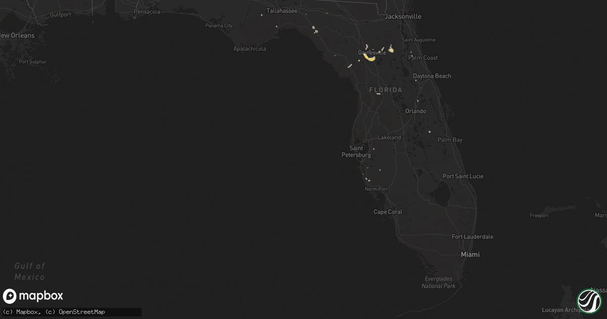
Hail Map in Florida on August 21, 2014
Get this storm
August 21 map
$229
one time, instant access
Download today. No call, no setup
Keep the $229
Bought the map and want the full workflow? Apply the entire $229 to a subscription within 7 days. None of it is wasted.
Every map, not just this one
This buys you this map. Subscription and you get every map we run, in the markets you choose from a few cities to whole states to nationwide. Plus real-time alerts the moment a storm fires.
Contact data
Name, contact info, occupancy, even credit band for addresses in the footprint. You go from where it hit to who to call.
Become the source they trust
Unlimited branding weather history reports on demand. You already have the documented answer ready for the property owner, and you are the one who showed up with it.
Property data and RoofTrace estimates
Pull up any address you have got, its value and the exact code rules for that jurisdiction, straight from One Click Code. Then RoofTrace estimates the squares, pitch, and roof value, priced the way you price.
Storm reports in Florida
Florida
| Date | Description |
|---|---|
| 08/21/20145:30 PM CDT | Alachua county 911/dispatch reports a tree downed along wachoota road in the vicinity of u.s. Highway 441 near micanopy. Time of damage based on radar data. |
| 08/21/20145:30 PM CDT | Trees and power lines down around perry |
| 08/21/20145:20 PM CDT | Alachua county 911/dispatch reports a large tree downed over county road 1474 near the intersection with u.s. Highway 301 northeast...blocking both lanes of the roadway |
| 08/21/20145:15 PM CDT | Report relayed by florida state watch office of minor roof damage to a manufactured home in the lake kathryn estates subdivision in casselberry. A storm spotter in the |
| 08/21/20144:35 PM CDT | Putnam county 911/dispatch reports significant tree damage...trees and powerlines downed in the vicinity of county road 315 west of lake grandin. Time of damage based o |
| 08/21/20144:35 PM CDT | Trees down near the intersection of old saint augustine road and southwood plantation road |
| 08/21/20144:30 PM CDT | Putnam county 911/dispatch reports trees and powerlines down in the vicinity of silver lake road. Time of damage based on radar data. |
All States Impacted by Hail Map on August 21, 2014
Cities Impacted by Hail Map on August 21, 2014
- Aurora, NE
- Willow Beach, AZ
- Mankato, KS
- Essex, CA
- Buhl, ID
- Franklin, GA
- Lagrange, GA
- Burr Oak, KS
- Clarington, PA
- Lafayette, IN
- Stanton, TX
- Roberts, ID
- Menan, ID
- Rexburg, ID
- Lewisville, ID
- Rigby, ID
- Alton, KS
- Woodston, KS
- Plainville, KS
- Natoma, KS
- Hagerman, ID
- Slade, KY
- Stanton, KY
- Rogers, KY
- Pine Ridge, KY
- Campton, KY
- Melrose, FL
- Interlachen, FL
- Sunray, TX
- Sarasota, FL
- Clarks Hill, IN
- Newport, NC
- Morehead City, NC
- Landisburg, PA
- Newville, PA
- Lamesa, TX
- Webber, KS
- Dillsburg, PA
- Boiling Springs, PA
- Wendell, ID
- Montrose, PA
- Friendsville, PA
- Riverdale, IL
- Chicago, IL
- Blue Island, IL
- Dolton, IL
- Hays, KS
- Cumberland, IA
- Starlight, PA
- Starrucca, PA
- Deposit, NY
- Equinunk, PA
- Hancock, NY
- Susquehanna, PA
- Hardy, NE
- Remington, IN
- Lake Como, PA
- Long Eddy, NY
- Twin Falls, ID
- Carson, IA
- Oakland, IA
- Oak Lawn, IL
- Chicago Ridge, IL
- Holton, KS
- Odessa, TX
- Coopersburg, PA
- Center Valley, PA
- Greeley, PA
- Hawley, PA
- Yuma, AZ
- Carlisle, PA
- Loysville, PA
- Port Royal, PA
- Ickesburg, PA
- Jacksonville, AL
- Wellington, AL
- Gadsden, AL
- Honesdale, PA
- West Lafayette, IN
- Benedict, NE
- Stromsburg, NE
- York, NE
- Newtown, MO
- Lewis, IA
- Atlantic, IA
- Carthage, MS
- Lumberton, MS
- Brookhaven, MS
- Bogue Chitto, MS
- Colfax, IN
- Hellertown, PA
- Paupack, PA
- Oakdale, LA
- Pineville, LA
- Castleford, ID
- Beattyville, KY
- Matamoras, PA
- Port Jervis, NY
- Montague, NJ
- Pendleton, IN
- Breaux Bridge, LA
- Arnaudville, LA
- Spickard, MO
- Princeton, MO
- Wabash, IN
- Cresco, IA
- Lime Springs, IA
- Elma, IA
- Dryden, TX
- Mendota, IL
- Sublette, IL
- Dingmans Ferry, PA
- Shorterville, AL
- Abbeville, AL
- Mystic, IA
- Pelham, GA
- Hosford, FL
- Lebanon, KS
- Dayton, IN
- Mulberry, IN
- Frankfort, IN
- Calexico, CA
- Holtville, CA
- Romney, IN
- Moravia, IA
- Centerville, IA
- Beaufort, NC
- Frenchburg, KY
- Archer, FL
- Micanopy, FL
- Gainesville, FL
- Ithaca, NY
- Trumansburg, NY
- Davenport, NE
- Shickley, NE
- Lagro, IN
- Andrews, IN
- Treynor, IA
- Ballard, WV
- Forest Hill, WV
- Lewisburg, PA
- Milford, PA
- Tafton, PA
- Shohola, PA
- Brandon, MS
- Amboy, IN
- Peru, IN
- Converse, IN
- La Fontaine, IN
- Albany, GA
- French Settlement, LA
- Livingston, LA
- Newberry, FL
- Lebanon, IN
- Thorntown, IN
- Kimberly, ID
- Gaines, PA
- Coudersport, PA
- Genesee, PA
- Ulysses, PA
- Galeton, PA
- Lodge Grass, MT
- Lecompte, LA
- Woodburn, IA
- New Virginia, IA
- Blythe, CA
- Albia, IA
- Kouts, IN
- Medaryville, IN
- North Judson, IN
- Wheatfield, IN
- La Crosse, IN
- San Pierre, IN
- Lafayette, LA
- Saint Cloud, FL
- Harvey, IL
- Dupree, SD
- Gilboa, NY
- Ottawa, IL
- Bellwood, NE
- Rising City, NE
- David City, NE
- Shelby, NE
- Madison, MS
- Perry, FL
- Goldsmith, TX
- Francesville, IN
- Esbon, KS
- Concordia, KS
- De Leon Springs, FL
- Villisca, IA
- Brawley, CA
- Imperial, CA
- Bluffton, GA
- Thomasville, GA
- Griswold, IA
- Henderson, IA
- Macedonia, IA
- Morocco, IN
- Wysox, PA
- Chariton, IA
- Alexandria, LA
- Linwood, NE
- Hobart, IN
- Portage, IN
- Merrillville, IN
- Valparaiso, IN
- Winfield, PA
- Mifflinburg, PA
- Henderson, NE
- Woodworth, LA
- Magee, MS
- Blain, PA
- Mount Holly Springs, PA
- York Springs, PA
- Granville, PA
- Mifflin, PA
- Honey Grove, PA
- Lewistown, PA
- Gary, IN
- Hammond, IN
- Albany, IN
- Redkey, IN
- Superior, NE
- Moore, ID
- Arco, ID
- Gresham, NE
- Mountain Lake, MN
- Bruno, NE
- Morse Bluff, NE
- Norwood, GA
- Ellis, KS
- Crawfordville, FL
- Chiefland, FL
- Gooding, ID
- Delphi, IN
- Nickerson, NE
- Arlington, NE
- Camilla, GA
- Crescent, IA
- Underwood, IA
- Council Bluffs, IA
- Shorewood, IL
- Elwood, IL
- Joliet, IL
- Manhattan, IL
- Channahon, IL
- Minooka, IL
- Buena Vista, GA
- Udell, IA
- Moulton, IA
- Madison, GA
- Midland, TX
- Sutton, NE
- Goldonna, LA
- Dawson, GA
- Monticello, IN
- Idaville, IN
- Hartford City, IN
- Montpelier, IN
- Marion, IN
- Sumner, GA
- Sylvester, GA
- Seneca, SC
- Fremont, NE
- Waterville, WA
- Perryton, TX
- Van Buren, IN
- Emmaus, PA
- Edison, GA
- Headland, AL
- Newville, AL
- Reddick, IL
- Rensselaer, IN
- Marseilles, IL
- Sigel, PA
- Leeper, PA
- Strattanville, PA
- Vowinckel, PA
- Greenville, WV
- Vega, TX
- Morris, PA
- Waterville, PA
- Bethlehem, PA
- Riegelsville, PA
- Myakka City, FL
- Cedar Run, PA
- Trout Run, PA
- Brownsburg, IN
- Brookston, IN
- Battle Ground, IN
- Pittsboro, IN
- Natchitoches, LA
- Little Meadows, PA
- Brackney, PA
- Pennington Gap, VA
- Ralph, SD
- Fort Stockton, TX
- Hampstead, MD
- Columbia, AL
- Hanover, PA
- Ridgeland, MS
- Searchlight, NV
- Jean, NV
- Dunkirk, IN
- Alachua, FL
- Saronville, NE
- Ong, NE
- Geneva, NE
- Edgar, NE
- Nipton, CA
- Lake Panasoffkee, FL
- Supply, NC
- Streator, IL
- Orient, IA
- Cross City, FL
- Mount Olive, MS
- Wolcott, IN
- Soldier, KS
- Circleville, KS
- Humboldt, NE
- Trumbull, NE
- Giltner, NE
- Glenville, PA
- Glen Rock, PA
- Agenda, KS
- Blackfoot, ID
- Truro, IA
- Lakeville, PA
- Lackawaxen, PA
- Odell, IL
- Cornell, IL
- Glasco, KS
- Beloit, KS
- Cusseta, GA
- La Grange, IL
- Brookfield, IL
- Lyons, IL
- Cabery, IL
- Emington, IL
- Surprise, NE
- Harvard, NE
- Ludlow, SD
- Elliott, IA
- Red Oak, IA
- Riverview, FL
- Jackson, MN
- Morgan, GA
- Angie, LA
- Sandy Hook, MS
- Mount Ayr, IN
- Brook, IN
- Towanda, PA
- Buffalo, IN
- Lamont, FL
- Spearman, TX
- Elmer, LA
- Richland, GA
- Leary, GA
- Bunnell, FL
- Madison, FL
- Jefferson, OH
- Dorset, OH
- Jewell, KS
- Columbus, GA
- Ravenna, KY
- Irvine, KY
- Winterhaven, CA
- Filer, ID
- Pollock, LA
- Alzada, MT
- Warren, IN
- Huntington, IN
- Hunter, KS
- Surgoinsville, TN
- Newton, GA
- Waco, NE
- Winamac, IN
- Lindside, WV
- Florahome, FL
- Hawthorne, FL
- Blackstone, IL
- Lake Mary, FL
- Longwood, FL
- Saint Amant, LA
- Philadelphia, MS
- Port Crane, NY
- Ulysses, NE
- Red Cloud, NE
- Greenfield, IA
- Taylorsville, NC
- Reynolds, IN
- Silver Creek, MS
- Hebron, IN
- Lowell, IN
- Philipsburg, PA
- Allport, PA
- Munson, PA
- Morrisdale, PA
- Hawk Run, PA
- Monroe, LA
- Newfoundland, PA
- Greentown, PA
- Lake Ariel, PA
- Sussex, NJ
- Layton, NJ
- Branchville, NJ
- South Sterling, PA
- Demotte, IN
- Marathon, TX
- Clayton, LA
- Andover, OH
- Fair Oaks, IN
- Michigantown, IN
- Rossville, IN
- Bringhurst, IN
- Flora, IN
- Cutler, IN
- Grand Ridge, IL
- Crown Point, IN
- Beaver, OK
- Hastings, FL
- Crosby, MS
- Pollock, MO
- Dwight, IL
- Nemaha, NE
- Lumpkin, GA
- Manchester, MD
- Cuthbert, GA
- Upland, IN
- Corning, IA
- Massena, IA
- Piedmont, AL
- Kirksville, MO
- Wellton, AZ
- Callicoon, NY
- Damascus, PA
- Osceola, IA
- Sunset Beach, NC
- Calabash, NC
- Ocean Isle Beach, NC
- Canadensis, PA
- Bolivia, NC
- Walker, LA
- Binghamton, NY
- La Plata, MO
- Jamestown, KS
- Deland, FL
- Harris, MO
- Eaton, IN
- Bronson, FL
- Lucas, IA
- Earleton, FL
- Ball, LA
- Hastings, NE
- Elmer, MO
- Ethel, MO
- Palos Heights, IL
- Worth, IL
- Crestwood, IL
- Bridgeview, IL
- South Holland, IL
- Palos Hills, IL
- Hickory Hills, IL
- Posen, IL
- Midlothian, IL
- Alsip, IL
- Robbins, IL
- Chalmers, IN
- Randall, KS
- Courtland, KS
- El Centro, CA
- Warm Springs, GA
- Manchester, GA
- Columbia, LA
- Zoe, KY
- Bradenton, FL
- Nelson, NE
- Keystone Heights, FL
- Norway, KS
- Parkton, MD
- Calipatria, CA
- Weaver, AL
- Rome, OH


