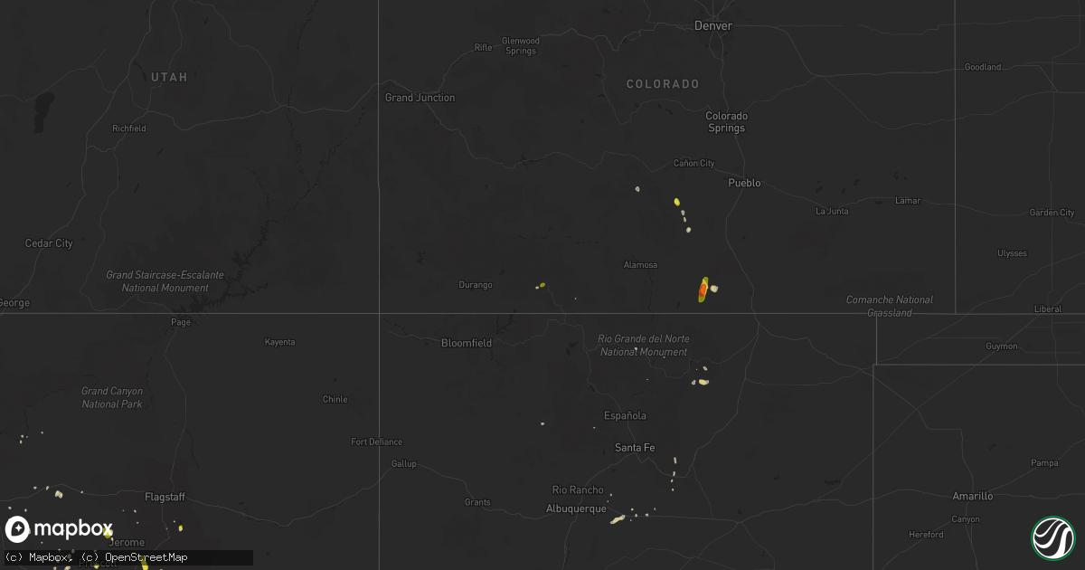
Hail Map on August 20, 2016
Get this storm
August 20 map
$229
one time, instant access
Download today. No call, no setup
Keep the $229
Bought the map and want the full workflow? Apply the entire $229 to a subscription within 7 days. None of it is wasted.
Every map, not just this one
This buys you this map. Subscription and you get every map we run, in the markets you choose from a few cities to whole states to nationwide. Plus real-time alerts the moment a storm fires.
Contact data
Name, contact info, occupancy, even credit band for addresses in the footprint. You go from where it hit to who to call.
Become the source they trust
Unlimited branding weather history reports on demand. You already have the documented answer ready for the property owner, and you are the one who showed up with it.
Property data and RoofTrace estimates
Pull up any address you have got, its value and the exact code rules for that jurisdiction, straight from One Click Code. Then RoofTrace estimates the squares, pitch, and roof value, priced the way you price.
States Impacted by Hail Map on August 20, 2016
Storm reports
Wisconsin
| Date | Description |
|---|---|
| 08/20/201610:05 AM CDT | Update of previous report. Kewaunee county em reports 20+ trees uprooted or damaged. Several roofs with shingle damage. Siding off at least 1 home. Small trailer flippe |
| 08/20/201610:03 AM CDT | A brief ef0 tornado hit the west side of the city of kewaunee. About 100 trees sustained broken limbs or were uprooted. Several homes had shingle or siding damage. |
South Carolina
| Date | Description |
|---|---|
| 08/20/20165:47 PM CDT | South carolina highway patrol reported a tree down and in the roadway on keans neck road near the intersection with kinloch road. |
| 08/19/20167:45 PM CDT | South carolina highway patrol reported a tree down on mack drive just a bit north of hw-17a near jamestown. |
| 08/19/20167:41 PM CDT | A tree was blown down across the 4000 block of route 17a. Time was estimated from radar data. |
West Virginia
| Date | Description |
|---|---|
| 08/20/20164:28 PM CDT | Tree fell down on a house and also knocked down power lines. |
Tennessee
| Date | Description |
|---|---|
| 08/20/20164:00 PM CDT | A few limbs were blown down. |
| 08/20/20163:53 PM CDT | A few trees were blown down on harpeth peytonsville road in college grove. |
Colorado
| Date | Description |
|---|---|
| 08/20/20165:25 PM CDT | Accompanied by heavy rain. |
| 08/19/20167:35 PM CDT | . |
Kentucky
| Date | Description |
|---|---|
| 08/20/20165:32 PM CDT | Ef-0 tornado... Max wind 70-80 mph...30 yard path width...corn flattened and roof torn off a large metal outbuilding. |
| 08/20/20164:53 PM CDT | Several trees down and a barn blown down. |
Ohio
| Date | Description |
|---|---|
| 08/20/20166:40 PM CDT | Trained spotter reported tornado on the ground. |
| 08/20/20166:20 PM CDT | Shed blown over on grise road. Time estimated based on radar. |
| 08/20/20165:59 PM CDT | Numerous trees down. No structural damage to homes. |
| 08/20/20165:50 PM CDT | Estimated 2 ft diameter tree uprooted at delaware state park. Photo verified. Time estimated based on radar. |
| 08/20/20165:38 PM CDT | Trained spotter at the darke county fair called to report a tornado on the ground looking east from greenville... Ohio. |
| 08/20/20165:37 PM CDT | Damage survey confirmed ef0 with an intermittent path length of 3.3 miles and a maximum width of 100 yards. |
| 08/20/20165:17 PM CDT | Possible tornado at gettysburg-pitsburg road. Photos depict large truck overturned and a very large tree uprooted. Time estimated based on radar. |
| 08/20/20165:15 PM CDT | A farm in the 5200 block of gettysburg-pitsburg road sustained ef0 tornado damage to its barn and a tractor trailer. Crop damage continued for a few miles further north |
Michigan
| Date | Description |
|---|---|
| 08/20/20163:27 PM CDT | Trees down . |
| 08/20/20163:24 PM CDT | Trained spotter reports many downed large trees at perkins near leonard blocking road. Trees trunks about 3 ft diameter. |
| 08/20/20163:03 PM CDT | .96 inch rain... Branches and trees down in the area. |
| 08/20/20162:55 PM CDT | Crooked pine drive... Crooked pine court intersection 1~1.5 dia full pine tree down. One leaning on a house . |
| 08/20/20162:15 PM CDT | Radar indicated tornado. Numerous trees down...with one across road. Limbs on power lines. Several pine trees snapped off 5 to 6 feet off of ground. Power out. Time of |
| 08/20/20162:10 PM CDT | Nws damage survey confirmed an ef-1 tornado in ionia and montcalm counties. Tornado damage began just east of the small town of orleans and moved northeast where it cro |
| 08/20/20161:51 PM CDT | Received a call from the public reporting several downed tree limbs. Largest limb downed in her yard is 6 inches in diameter. . |
| 08/20/20161:50 PM CDT | A brief ef-o tornado touched down in kent county near perkins avenue ne between leonard street ne and knapp street ne. Tree damage and some property damage from fallen |
| 08/20/20161:42 PM CDT | Trees down on houses near 32nd st and highgate ave also 2900 blk longstreet ave. Possible tornado. |
| 08/20/20161:38 PM CDT | Debris in the air near 40th and ivanrest. |
| 08/20/20161:31 PM CDT | 911 call center relayed a call from the public. Extensive wind damage being observed in wyoming. Several trees down in the area. Possible damage to house. Extent of dam |
| 08/20/20161:31 PM CDT | Tree reported down on m6... Blocking the right hand lane of east bound traffic. |
| 08/20/20161:23 PM CDT | Trees and powerlines down near 20th & adams per fire dept. Multiple reports of a funnel cloud or tornado. |
| 08/20/20161:16 PM CDT | Spotter estimated wind gust. Time estimated by radar. . |
| 08/20/20161:11 PM CDT | Large limb of a maple tree snapped. Some rot was noted. Some damage also to the roof of the front porch. Time estimated from radar. |
| 08/20/201612:45 PM CDT | Trees down and damage to a house. Debris signature on radar. |
| 08/20/201612:20 PM CDT | An off-duty nws employee estimated wind gusts around 65 mph. No damage was observed in south haven at the time of the call. . |
| 08/20/201612:15 PM CDT | Tress and powerlines down. Roof torn off. Radar confirmed debris signature. |
Arizona
| Date | Description |
|---|---|
| 08/20/20163:25 PM CDT | A local report indicates 1.25 inch wind near PRESCOTT |
| 08/20/20162:59 PM CDT | .75 to 1 inch size hail covered the ground. |
| 08/19/201610:15 PM CDT | Tbra3 gust to 62 mph. |
| 08/19/20168:30 PM CDT | Downed tree reported at a hotel by staff. . |
Indiana
| Date | Description |
|---|---|
| 08/20/20164:50 PM CDT | Trained spotter reports a tornado on the ground at the intersection of notestine and schwartz road. Report relayed by amateur radio. |
| 08/20/20164:42 PM CDT | Ef0 tornado touched down just south of young/flutter road intersection. Extensive corn damage at this location... Along with sporadic damage for 2.4 mile path to the no |
| 08/20/20164:40 PM CDT | Large tree limb downed. Time estimated from radar. . |
| 08/20/20164:36 PM CDT | Small tree limbs less than six inches in diameter down near evard and maplecrest roads. Time estimated from radar. . |
| 08/20/20164:35 PM CDT | Relayed by trained spotter. Report of small trees and limbs down near st. Joe and st. Joe center roads. Time estimated from radar. . |
| 08/20/20162:19 PM CDT | Brief ef0 tornado touchdown just west of cr 133...south of us 6. Minor home damage to 2 homes... As well as snapped tree limbs and edge of a corn field flattened. Maxim |
Alabama
| Date | Description |
|---|---|
| 08/20/20164:32 PM CDT | Report of tree down near ozark |
| 08/20/20163:37 PM CDT | Couple trees down near the intersection of wire rd and shug jordan pkwy. Winds estimated 40-50 mph based on radar and nearby observation. Time estimated from radar. |
| 08/19/20168:30 PM CDT | Tree down across the rd near the intersection of rifle range rd and dozier rd. Winds estimated around 30 mph based on radar. Time estimated by radar. |
Cities Impacted by Hail Map on August 20, 2016
- Payson, AZ
- San Jose, NM
- Ribera, NM
- Tilden, TX
- Chino Valley, AZ
- Clarkdale, AZ
- Weston, CO
- Moriarty, NM
- Zapata, TX
- Wickenburg, AZ
- Kirkland, AZ
- Gardner, CO
- Fort Davis, TX
- Tijeras, NM
- Edgewood, NM
- Wellton, AZ
- Seligman, AZ
- Sedona, AZ
- Mormon Lake, AZ
- Ash Fork, AZ
- Cotulla, TX
- Ojo Caliente, NM
- Sandia Park, NM
- Fort Hancock, TX
- Cimarron, NM
- Westcliffe, CO
- Congress, AZ
- Crown King, AZ
- Prescott, AZ
- Mayer, AZ
- Moffat, CO
- Auburn University, AL
- Auburn, AL
- Peridot, AZ
- Pagosa Springs, CO
- Stanley, NM
- Roll, AZ
- Black Canyon City, AZ
- La Veta, CO