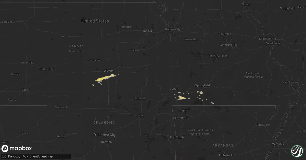
Hail Map in Kansas on August 17, 2011
Get this storm
August 17 map
$229
one time, instant access
Download today. No call, no setup
Keep the $229
Bought the map and want the full workflow? Apply the entire $229 to a subscription within 7 days. None of it is wasted.
Every map, not just this one
This buys you this map. Subscription and you get every map we run, in the markets you choose from a few cities to whole states to nationwide. Plus real-time alerts the moment a storm fires.
Contact data
Name, contact info, occupancy, even credit band for addresses in the footprint. You go from where it hit to who to call.
Become the source they trust
Unlimited branding weather history reports on demand. You already have the documented answer ready for the property owner, and you are the one who showed up with it.
Property data and RoofTrace estimates
Pull up any address you have got, its value and the exact code rules for that jurisdiction, straight from One Click Code. Then RoofTrace estimates the squares, pitch, and roof value, priced the way you price.
Storm reports in Kansas
Kansas
| Date | Description |
|---|---|
| 08/17/20116:58 PM CDT | Viola fire department estimates 65 to 75 mph winds and visibilities reduced to an eighth of a mile. |
| 08/17/20116:55 PM CDT | A local report indicates 60 MPH wind near CLEARWATER |
| 08/17/20116:52 PM CDT | Viola fire department reports at least 60 mile per hour winds. |
| 08/17/20116:52 PM CDT | Trained spotter estimates 50 to 60 mph winds. |
| 08/16/20118:58 PM CDT | Trained spotter estimates 60 to 65 mph winds and pea sized hail. |
| 08/16/20118:45 PM CDT | Trained spotter estimates winds up to 60 mph. |
| 08/16/20118:00 PM CDT | Trained spotter estimates 70 mph winds and had nickel sized hail. |
| 08/16/20117:55 PM CDT | Delayed report that rec center roof was peeled off causing an inch of standing water with the subsequent rain. |
| 08/16/20117:55 PM CDT | Delayed report. Two barn roofs were blown off 1 to 2 miles east of rose hill. |
| 08/16/20117:51 PM CDT | Trained spotter estimates 55 to 60 mph winds. |
| 08/16/20117:37 PM CDT | A local report indicates 58 MPH wind near DERBY |
| 08/16/20117:36 PM CDT | Trained spotter estimates winds of 70 to 75 mph. |
| 08/16/20117:16 PM CDT | Wind gusts of at least 70 mph winds having been affecting clearwater for about 15 minutes now. A trained spotter reported a large mature tree uprooted. |
| 08/16/20117:14 PM CDT | Trained spotter estimates at least 70 mph winds and heavy rain with greatly reduced visibility. |
| 08/16/20117:07 PM CDT | Trained spotter estimates 70 mph winds with pea sized hail. |
All States Impacted by Hail Map on August 17, 2011
Cities Impacted by Hail Map on August 17, 2011
- Merriman, NE
- Cody, NE
- Chappell, NE
- Branson, MO
- Charlotte, MI
- White River, SD
- Boncarbo, CO
- Trinidad, CO
- Clewiston, FL
- Mission, SD
- Highlandville, MO
- Naper, NE
- Mills, NE
- Karval, CO
- Rush, CO
- Galena, MO
- Mullen, NE
- Elizabethtown, KY
- Cecilia, KY
- Wood, SD
- Joiner, AR
- Boone, CO
- Colorado Springs, CO
- Pueblo, CO
- Okeechobee, FL
- Lewellen, NE
- Lecanto, FL
- Valentine, NE
- Montevideo, MN
- Midland, SD
- Altamonte Springs, FL
- Casselberry, FL
- Granby, MO
- Holyoke, CO
- Champion, NE
- Conway Springs, KS
- Winner, SD
- Trinchera, CO
- Oneill, NE
- Goodman, MO
- Neosho, MO
- Whitman, NE
- Okaton, SD
- Belvidere, SD
- Monett, MO
- Pangburn, AR
- Wilburn, AR
- Niagara, ND
- Ocklawaha, FL
- Silver Springs, FL
- Colome, SD
- Lakota, ND
- Rose Hill, KS
- Derby, KS
- Douglass, KS
- Mulvane, KS
- Bassett, AR
- Arlington, CO
- Port Saint Lucie, FL
- Draper, SD
- Stella, MO
- Rocky Comfort, MO
- Exeter, MO
- Fairview, MO
- Crook, CO
- Lodgepole, NE
- Sidney, NE
- Sheyenne, ND
- Saint Michael, ND
- Mcville, ND
- Michigan, ND
- Argonia, KS
- Akron, CO
- Kiowa, CO
- Elbert, CO
- Lindon, CO
- Miami, OK
- Quapaw, OK
- Purdy, MO
- Cassville, MO
- Ordway, CO
- Fort Pierce, FL
- Rueter, MO
- Protem, MO
- Judsonia, AR
- Flagler, CO
- Otis, CO
- Memphis, TN
- Folsom, NM
- Leeds, ND
- Saint Francis, SD
- Tolna, ND
- Crary, ND
- Warwick, ND
- Orlando, FL
- Hugo, CO
- Sierra Vista, AZ
- Milton, KS
- Oviedo, FL
- Kenansville, FL
- Homosassa, FL
- Hernando, FL
- Frenchmans Bayou, AR
- Spencer, NE
- Murdo, SD
- Ocala, FL
- Dunnellon, FL
- Raton, NM
- Batesville, AR
- Billings, MO
- Ozark, MO
- Clever, MO
- Nixa, MO
- Crane, MO
- Las Animas, CO
- Benson, AZ
- Drasco, AR
- Springview, NE
- Munfordville, KY
- Upton, KY
- Clarkson, KY
- Tryon, NE
- Engadine, MI
- Eckerman, MI
- Stuart, NE
- Woodrow, CO
- Devils Lake, ND
- Sugar City, CO
- Deer Trail, CO
- Fort Pierre, SD
- Anthony, KS
- Harper, KS
- Peyton, CO
- Spring Hill, FL
- Geneva, FL
- Amherst, CO
- Reeds Spring, MO
- Tracy, MN
- Floral, AR
- Haswell, CO
- Cando, ND
- Bradford, AR
- Wolford, ND
- Turrell, AR
- Dyess, AR
- Pierce City, MO
- Bisbee, ND
- Calhan, CO
- Welch, OK
- Wheaton, MO
- Oshkosh, NE
- Ainsworth, NE
- Clearwater, KS
- Brooksville, FL
- Granada, CO
- Webster, FL
- Apopka, FL
- Churchs Ferry, ND
- Wilson, AR
- Indiantown, FL
- Bald Knob, AR
- Millington, TN
- Forsyth, MO
- Dallas, SD
- Sparks, NE
- Atkinson, NE
- Butte, NE
- Milan, KS
- Rosebud, SD
- Clermont, FL
- Groveland, FL
- Carrizozo, NM
- Wellington, KS
- Peck, KS
- Bushnell, FL
- Pekin, ND
- Anderson, MO
- Presho, SD
- Belle Plaine, KS
- Merino, CO
- Hayes, SD
- Titusville, FL
- Largo, FL
- Seminole, FL
- Mountain View, AR
- Marked Tree, AR
- Haysville, KS
- Oberon, ND
- Dahlen, ND
- Tombstone, AZ
- Aurora, MO
- South Bay, FL
- Brocket, ND
- Picher, OK
- Stark City, MO
- Joplin, MO
- Seneca, MO
- Petersburg, ND
- New Rockford, ND
- Mchenry, ND
- Verona, MO
- Cape Fair, MO
- Okreek, SD
- Lorida, FL
- Lake City, AR
- Melbourne, AR


