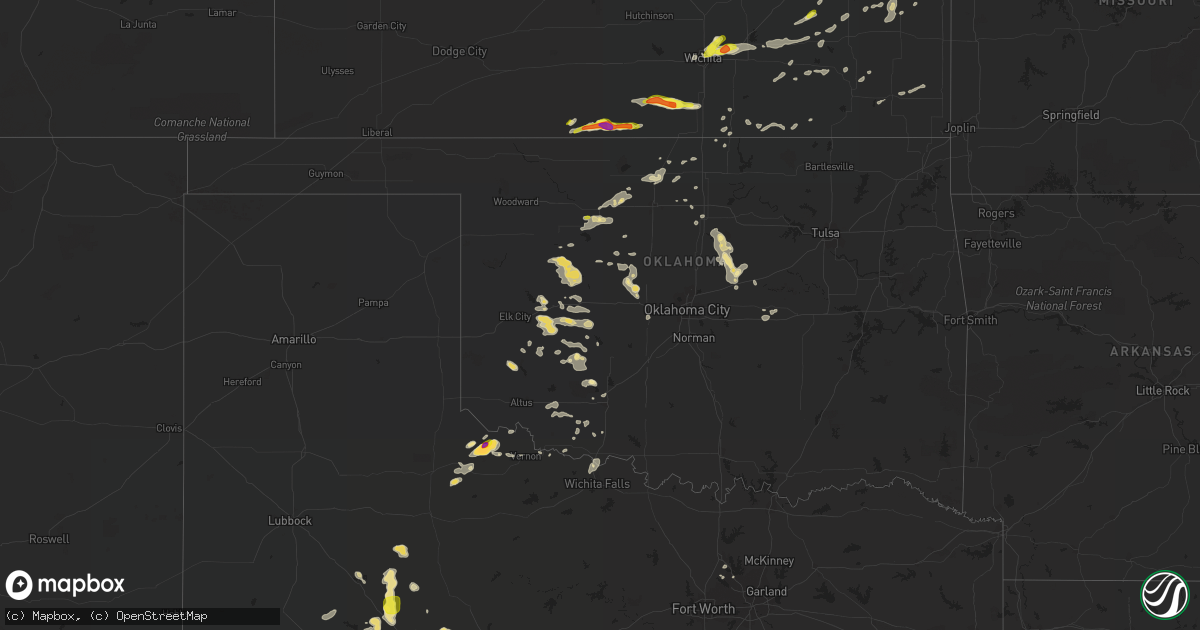
Hail Map in Oklahoma on August 16, 2017
Get this storm
August 16 map
$229
one time, instant access
Download today. No call, no setup
Keep the $229
Bought the map and want the full workflow? Apply the entire $229 to a subscription within 7 days. None of it is wasted.
Every map, not just this one
This buys you this map. Subscription and you get every map we run, in the markets you choose from a few cities to whole states to nationwide. Plus real-time alerts the moment a storm fires.
Contact data
Name, contact info, occupancy, even credit band for addresses in the footprint. You go from where it hit to who to call.
Become the source they trust
Unlimited branding weather history reports on demand. You already have the documented answer ready for the property owner, and you are the one who showed up with it.
Property data and RoofTrace estimates
Pull up any address you have got, its value and the exact code rules for that jurisdiction, straight from One Click Code. Then RoofTrace estimates the squares, pitch, and roof value, priced the way you price.
Storm reports in Oklahoma
Oklahoma
| Date | Description |
|---|---|
| 08/16/20176:55 PM CDT | A local report indicates 60 MPH wind near 5 NNW TONKAWA |
| 08/16/20176:14 PM CDT | A local report indicates 60 MPH wind near 4 NW ISABELLA |
| 08/16/20176:12 PM CDT | Powerpole down and metal shed destroyed. |
| 08/16/20171:30 AM CDT | A local report indicates 66 MPH wind near 3 W GRANDFIELD |
| 08/16/20171:07 AM CDT | 3 inch tree limbs and power poles broken. |
| 08/16/201712:40 AM CDT | Several shingles blown off roof along with several 1 to 2 inch tree limbs down. |
| 08/16/201712:30 AM CDT | Power pole down. |
| 08/15/20179:47 PM CDT | A local report indicates 60 MPH wind near PERKINS |
| 08/15/20179:39 PM CDT | Estimated 60-70 mph wind blew off metal roof to four car garage. Several 4-8 inch diameter tree limbs twisted off at the same location. Time estimated by radar. |
| 08/15/20179:32 PM CDT | Large transmission tower downed at pso plant. |
| 08/15/20179:02 PM CDT | Tractor trailer blown over. |
| 08/15/20178:30 PM CDT | A local report indicates 63 MPH wind near 1 W KINGFISHER |
| 08/15/20178:06 PM CDT | 6 to 8 inch tree branches blown off. |
| 08/15/20178:00 PM CDT | A local report indicates 76 MPH wind near 7 SW SOONER LAKE |
| 08/15/20177:15 PM CDT | Several power poles snapped. Several medium to large trees broken as well. |
| 08/15/20177:10 PM CDT | A local report indicates 71 MPH wind near 4 SSE BLACKWELL |
| 08/15/20177:04 PM CDT | A local report indicates 60 MPH wind near 1 WSW VANCE AIR FORCE B |
Cities Impacted by Hail Map on August 16, 2017
- Stanton, TX
- Midland, TX
- Arapaho, OK
- Clinton, OK
- Medicine Lodge, KS
- Kiowa, KS
- Hazelton, KS
- Waldron, KS
- Mayfield, KS
- Wellington, KS
- Girard, TX
- Jayton, TX
- London, TX
- Menard, TX
- Mason, TX
- Hermleigh, TX
- Snyder, TX
- Quanah, TX
- Garden City, TX
- Cordell, OK
- Lawton, OK
- Argonia, KS
- Milan, KS
- Sibley, MO
- Orrick, MO
- Richmond, MO
- Marathon, TX
- Chandler, OK
- Carney, OK
- Garber, OK
- Davidson, OK
- Medford, OK
- Deer Creek, OK
- Hardtner, KS
- Chillicothe, TX
- Nolan, TX
- Merkel, TX
- Sweetwater, TX
- Granite, OK
- Fairview, OK
- Robert Lee, TX
- Carnegie, OK
- Mountain View, OK
- Gotebo, OK
- Hartford, KS
- Madison, KS
- Ira, TX
- Colorado City, TX
- Westbrook, TX
- Taloga, OK
- Eureka, KS
- Rosalia, KS
- Corn, OK
- Hydro, OK
- Weatherford, OK
- Hartsburg, MO
- Sentinel, OK
- Independence, MO
- Howard, KS
- Kincaid, KS
- Colony, KS
- Welda, KS
- Garnett, KS
- La Harpe, KS
- Fall River, KS
- Watonga, OK
- Trent, TX
- Danville, KS
- Harper, KS
- Earlsboro, OK
- Seminole, OK
- Paden, OK
- Shawnee, OK
- Prague, OK
- Oklaunion, TX
- Vernon, TX
- Okarche, OK
- Calumet, OK
- Big Spring, TX
- Soldier, IA
- Ute, IA
- Mapleton, IA
- Harrisonville, MO
- Towanda, KS
- Benton, KS
- Augusta, KS
- Andover, KS
- Greenwich, KS
- Kechi, KS
- Wichita, KS
- Putnam, OK
- Custer City, OK
- Thomas, OK
- Altoona, KS
- Thayer, KS
- Winfield, KS
- Oxford, KS
- Geuda Springs, KS
- Perkins, OK
- Blackwell, TX
- Maryneal, TX
- Loyal, OK
- Kingfisher, OK
- Anthony, KS
- Stillwater, OK
- Rocksprings, TX
- Oakwood, OK
- Eldon, MO
- Russellville, MO
- Bessie, OK
- Dill City, OK
- Foss, OK
- Crowell, TX
- Paducah, TX
- Goltry, OK
- California, MO
- Rotan, TX
- Parker, KS
- Coahoma, TX
- Battle Creek, IA
- Ida Grove, IA
- Colony, OK
- Justiceburg, TX
- Le Roy, KS
- Flower Mound, TX
- Pond Creek, OK
- Junction, TX
- Ringwood, OK
- Valley Center, KS
- Wellston, OK
- Gillespie, IL
- Tryon, OK
- El Reno, OK
- Union City, OK
- Fort Cobb, OK
- Walters, OK
- Arkansas City, KS
- Del Rio, TX
- Chanute, KS
- El Dorado, KS
- Burkburnett, TX
- Adrian, MO
- Drexel, MO
- Cleo Springs, OK
- Helena, OK
- Meno, OK
- Girard, KS
- McCune, KS
- Okeene, OK
- Elgin, OK
- Blue Mound, KS
- Centerville, KS
- Hamilton, KS
- Harrold, TX
- Charter Oak, IA
- Danbury, IA
- High Ridge, MO
- Fenton, MO
- Bronte, TX
- Butler, OK
- Geary, OK
- Nardin, OK
- Boley, OK
- Okemah, OK
- Lewisville, TX
- Fort Sill, OK
- Snyder, OK
- Tipton, OK
- Frederick, OK
- Nash, OK
- Kremlin, OK
- Moorhead, IA
- Isabella, OK
- Hobart, OK
- Loveland, OK
- Piedmont, KS
- Grenola, KS
- Hunter, OK
- Coyle, OK
- Perry, OK
- Agra, OK
- Orlando, OK
- Sedan, KS
- Bunceton, MO
- Davenport, OK
- Lone Wolf, OK
- Denton, TX
- Argyle, TX
- Waterloo, IL
- Milan, MO
- Hitchcock, OK
- Saint Paul, KS
- Parsons, KS
- Wingate, TX
- Barnett, MO
- Randlett, OK
- Devol, OK
- Wichita Falls, TX
- Dexter, KS
- Cedar Vale, KS
- Fredonia, KS
- Benedict, KS
- Newkirk, OK
- Mound Valley, KS
- Dennis, KS
- Leon, KS
- Roby, TX
- Lohman, MO
- Indiahoma, OK
- Virgil, KS
- Yates Center, KS
- Faxon, OK
- Chattanooga, OK
- Cache, OK
- Toronto, KS
- Omega, OK
- Westphalia, KS
- Billings, OK
- Gail, TX
- Seiling, OK


