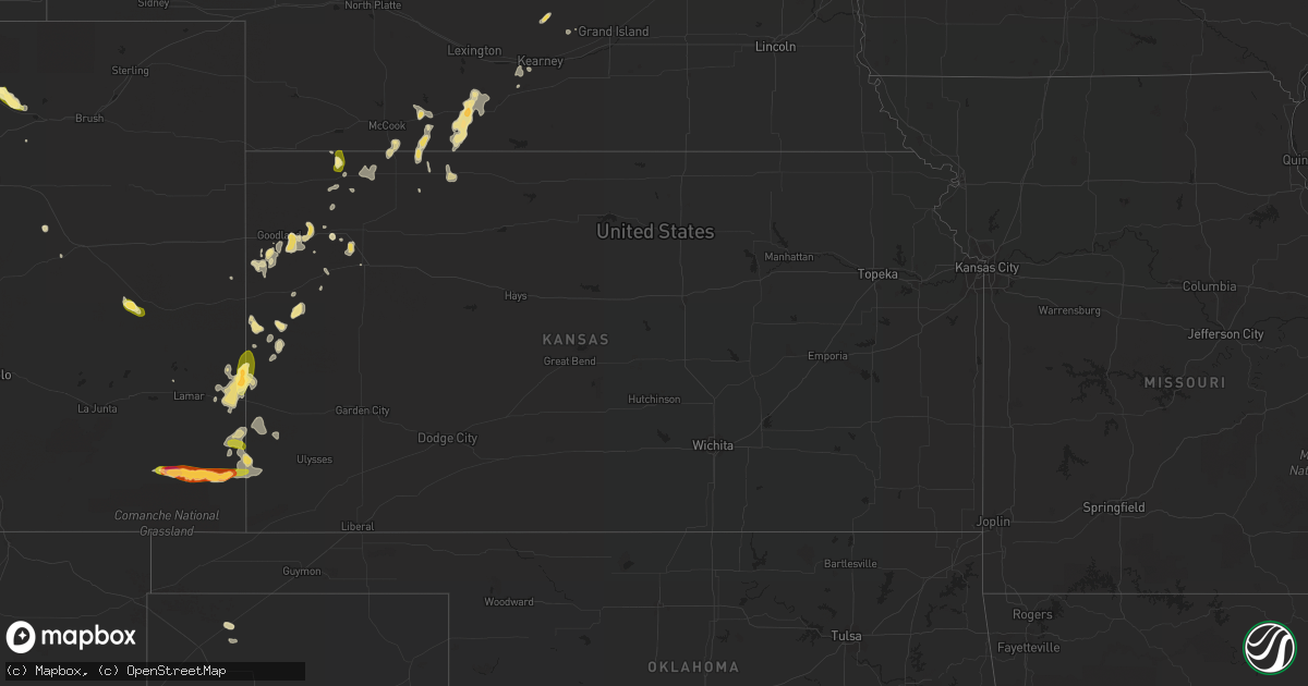
Hail Map in Kansas on August 16, 2015
Get this storm
August 16 map
$229
one time, instant access
Download today. No call, no setup
Keep the $229
Bought the map and want the full workflow? Apply the entire $229 to a subscription within 7 days. None of it is wasted.
Every map, not just this one
This buys you this map. Subscription and you get every map we run, in the markets you choose from a few cities to whole states to nationwide. Plus real-time alerts the moment a storm fires.
Contact data
Name, contact info, occupancy, even credit band for addresses in the footprint. You go from where it hit to who to call.
Become the source they trust
Unlimited branding weather history reports on demand. You already have the documented answer ready for the property owner, and you are the one who showed up with it.
Property data and RoofTrace estimates
Pull up any address you have got, its value and the exact code rules for that jurisdiction, straight from One Click Code. Then RoofTrace estimates the squares, pitch, and roof value, priced the way you price.
Storm reports in Kansas
Kansas
| Date | Description |
|---|---|
| 08/16/20155:26 PM CDT | Also experienced strong winds estimated at about 60 mph. |
| 08/16/20155:26 PM CDT | Also experienced strong winds estimated at about 60 mph. |
| 08/16/20154:10 PM CDT | A local report indicates 60 MPH wind near 8 S MCDONALD |
| 08/15/201511:21 PM CDT | The wind gust was at the johnson airport. |
| 08/15/20159:18 PM CDT | A local report indicates 65 MPH wind near 2 E LEOTI |
| 08/15/20158:54 PM CDT | Most of the hail was dime and nickel size. |
| 08/15/20158:15 PM CDT | Also had dime sized hail and some yard flooding 1 foot deep. No known flooding on roadways. |
| 08/15/20157:55 PM CDT | Power lost in city. |
All States Impacted by Hail Map on August 16, 2015
Cities Impacted by Hail Map on August 16, 2015
- Karval, CO
- Gill, CO
- Kersey, CO
- Dalhart, TX
- Livermore, CO
- Granada, CO
- Holly, CO
- Sheridan Lake, CO
- Lyons, CO
- Allenspark, CO
- Estes Park, CO
- Edison, NE
- Arapahoe, NE
- Livingston, TX
- Dodge, NE
- West Point, NE
- Scribner, NE
- Shallowater, TX
- Abernathy, TX
- Anton, TX
- Tie Siding, WY
- Lebanon, NE
- Booneville, MS
- Marietta, MS
- Cut Bank, MT
- Hanna, WY
- Florence, AL
- Cherokee, AL
- Tribune, KS
- Hendley, NE
- Beaver City, NE
- Bertrand, NE
- Atwood, KS
- Syracuse, KS
- Van Vleck, TX
- Wessington Springs, SD
- Alpena, SD
- Virgil, SD
- Palmer, NE
- Wolbach, NE
- Woonsocket, SD
- Vega, TX
- Hazard, NE
- Pleasanton, NE
- Colby, KS
- Wiley, CO
- Goodland, KS
- Edson, KS
- Weskan, KS
- Texhoma, OK
- Levant, KS
- Chamberlain, SD
- Pukwana, SD
- Oacoma, SD
- Reliance, SD
- Redrock, NM
- Danbury, NE
- Oberlin, KS
- Norcatur, KS
- McCook, NE
- Ward, CO
- Bay City, TX
- Florissant, CO
- Sealy, TX
- Rociada, NM
- Athens, WI
- Walsh, CO
- Springfield, CO
- Manter, KS
- Two Buttes, CO
- Kaycee, WY
- Columbia, TN
- Bartley, NE
- Iroquois, SD
- White Lake, SD
- Huron, SD
- Cavour, SD
- Garden, MI
- Wallace, KS
- Lubbock, TX
- Cimarron, NM
- Axtell, NE
- Petersburg, TN
- Fayetteville, TN
- Agate, CO
- Osceola, NE
- Arapahoe, CO
- Jamestown, CO
- Tombstone, AZ
- Norton, KS
- Brewster, KS
- Houston, TX
- Crosby, TX
- Gillette, WY
- Folsom, NM
- Cameron, LA
- Greeley, CO
- Washington, TX
- Lewisburg, TN
- Culleoka, TN
- Eaton, CO
- Jennings, KS
- Sharon Springs, KS
- Elm Creek, NE
- Funk, NE
- Holdrege, NE
- New Site, MS
- Dennis, MS
- Tishomingo, MS
- Meeker, CO
- Nederland, CO
- Roggen, CO
- Ravenna, NE
- Shelton, NE
- Crockett, TX
- Lovelady, TX
- Cambridge, NE
- Medicine Bow, WY
- McDonald, KS
- Artesian, SD
- Carthage, SD
- Bartlett, NE
- Winona, KS
- Silver City, NM
- Laramie, WY
- Indianola, NE
- Elwood, NE
- Stratford, TX
- Herndon, KS
- Wilsonville, NE
- Matheson, CO
- Brooksville, FL
- Bellvue, CO
- Mantachie, MS
- Oxford, NE
- Mora, NM
- Clarks, NE
- Oakley, KS
- Brenham, TX
- Chappell Hill, TX
- Stickney, SD
- Onalaska, TX
- De Smet, SD
- Snyder, NE
- Ord, NE
- Silver Creek, NE


