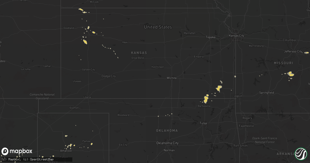
Hail Map on August 16, 2014
Get this storm
August 16 map
$229
one time, instant access
Download today. No call, no setup
Keep the $229
Bought the map and want the full workflow? Apply the entire $229 to a subscription within 7 days. None of it is wasted.
Every map, not just this one
This buys you this map. Subscription and you get every map we run, in the markets you choose from a few cities to whole states to nationwide. Plus real-time alerts the moment a storm fires.
Contact data
Name, contact info, occupancy, even credit band for addresses in the footprint. You go from where it hit to who to call.
Become the source they trust
Unlimited branding weather history reports on demand. You already have the documented answer ready for the property owner, and you are the one who showed up with it.
Property data and RoofTrace estimates
Pull up any address you have got, its value and the exact code rules for that jurisdiction, straight from One Click Code. Then RoofTrace estimates the squares, pitch, and roof value, priced the way you price.
States Impacted by Hail Map on August 16, 2014
Storm reports
Florida
| Date | Description |
|---|---|
| 08/16/20142:30 PM CDT | Sfwmd mesonet site near the center of lake okeechobee reported a northwest wind gust of 58 kts...or 67 mph...at 330 pm edt. Winds were sustained at 35 kts...or 40 mph. |
| 08/16/20142:15 PM CDT | Sfwmd mesonet site near the center of lake okeechobee reported a northwest wind gust of 50 kts...or 58 mph...at 315 pm edt. |
Montana
| Date | Description |
|---|---|
| 08/15/20147:17 PM CDT | A local report indicates 64 MPH wind near 2 SSE BAKER |
| 08/15/20147:00 PM CDT | Sheriff dispatch reported an 18 inch tree was uprooted on the west side of baker from very strong winds. Tin roofing material was ripped from the firehouse. Many tree b |
New Mexico
| Date | Description |
|---|---|
| 08/16/20141:30 AM CDT | Silver city newspaper reported 2 trees were knocked over and 1 landed on a vehicle which is possibly totaled. Silver city awos reported gust to 46 mph near this time. T |
Kansas
| Date | Description |
|---|---|
| 08/16/20145:30 PM CDT | Delayed report of trees down in parsons |
Arizona
| Date | Description |
|---|---|
| 08/15/20149:15 PM CDT | Hail fell for 20 minutes with the largest pieces being the size of quarters |
| 08/15/20149:15 PM CDT | Hail fell for 20 minutes with the largest pieces being the size of quarters |
| 08/15/20149:09 PM CDT | Hail lasted for 10 min. Max size 1 inch. |
North Dakota
| Date | Description |
|---|---|
| 08/15/201410:00 PM CDT | 50 by 100 foot tent at a wedding reception that was blown down. No injuries. 100 by 100 foot shed blown down. Employee estimated 60 to 70 mph winds. |
Texas
| Date | Description |
|---|---|
| 08/16/20146:05 PM CDT | Trees and power lines down in rosalee area near hwy 909 and in bogata |
| 08/16/20144:53 PM CDT | A local report indicates 68 MPH wind near 7 ENE AMARILLO |
| 08/16/20144:51 PM CDT | A local report indicates 68 MPH wind near 7 ENE AMARILLO |
| 08/16/20144:08 PM CDT | Numerous powerlines down. Some power lines downed on cars at 5600 greenville ave...some vehicles possibly damaged there as well. |
| 08/16/20143:35 PM CDT | Roof off of feed store |
North Carolina
| Date | Description |
|---|---|
| 08/16/20141:00 PM CDT | Trees down. |
Oklahoma
| Date | Description |
|---|---|
| 08/16/20146:37 PM CDT | A local report indicates 59 MPH wind near VANCE AIR FORCE BASE |
| 08/16/20146:30 PM CDT | Strong winds blew down tents and broke windows in downtown enid. |
| 08/16/20144:25 PM CDT | A local report indicates 1.00 inch wind near 13 N PERRY |
Cities Impacted by Hail Map on August 16, 2014
- Friona, TX
- Ben Franklin, TX
- Cooper, TX
- Colby, KS
- Ludell, KS
- Atwood, KS
- Globe, AZ
- Equality, IL
- Junction, IL
- Mound Valley, KS
- Hereford, TX
- Groom, TX
- Pampa, TX
- Crane, TX
- Willcox, AZ
- Caney, KS
- Independence, KS
- Metropolis, IL
- Garber, OK
- Farwell, TX
- Laquey, MO
- Richland, MO
- Waynesville, MO
- Amarillo, TX
- Panhandle, TX
- McDonald, KS
- Stonefort, IL
- Fort Worth, TX
- Paducah, KY
- Brookport, IL
- Lordsburg, NM
- Animas, NM
- Muleshoe, TX
- Ogallala, NE
- Azle, TX
- Wann, OK
- Coffeyville, KS
- Tyro, KS
- Copan, OK
- Dewey, OK
- Fort Stockton, TX
- Hermann, MO
- Bogata, TX
- Dumas, TX
- Buckhorn, NM
- Hoxie, KS
- Aspermont, TX
- Tucumcari, NM
- Bartlesville, OK
- Deport, TX
- Paris, TX
- Lake Creek, TX
- Pattonville, TX
- Sulphur Bluff, TX
- Parsons, KS
- Dennis, KS
- Galesburg, KS
- Altamont, KS
- Cherryvale, KS
- Gem, KS
- Saint Robert, MO
- Fort Leonard Wood, MO
- Crocker, MO
- Quinlan, TX
- Garland, KS
- Bronaugh, MO
- Keystone, NE
- Omaha, IL
- Ladonia, TX
- Alpine, AZ
- Golconda, IL
- Scammon, KS
- Monument, KS
- Bovina, TX
- Oakley, KS
- Winona, KS
- Bazine, KS
- Saint David, AZ
- Dike, TX
- Ransom, KS
- Flemington, MO
- Jamestown, ND
- Fort Lauderdale, FL
- Quinter, KS
- Utica, KS
- Capitan, NM
- Saint Xavier, MT
- Billings, OK
- Mount Lemmon, AZ
- Oracle, AZ
- Lenapah, OK
- Liberty, KS
- Camp Crook, SD
- Karnak, IL
- West Paducah, KY
- Belknap, IL
- Grantsburg, IL
- Kevil, KY
- Barlow, KY
- Wickliffe, KY
- Grand Chain, IL
- La Center, KY
- Tombstone, AZ
- Benson, AZ
- Ness City, KS
- Hopkinsville, KY
- Rosiclare, IL
- Silver City, NM
- Mims, FL
- Cocoa, FL
- Hickory, KY
- Boaz, KY
- Vale, SD
- Hurley, NM
- Brownell, KS
- Dove Creek, CO
- Saint Paul, KS
- Erie, KS
- Tucson, AZ
- Lebanon, MO
- Fort Scott, KS
- Madrid, NE
- Rosebud, MT
- Roxton, TX
- Pecan Gap, TX
- Jennings, KS
- Ozark, IL
- Simpson, IL
- Humansville, MO
- Titusville, FL
- Stoutland, MO
- San Simon, AZ
- Houston, TX
- Mount Sterling, MO
- Morrison, MO
- Chamois, MO
- Cave In Rock, IL
- Steele, ND
- Enid, OK
- Buffalo, SD
- Harrisburg, IL
- Shawneetown, IL
- Ridgway, IL