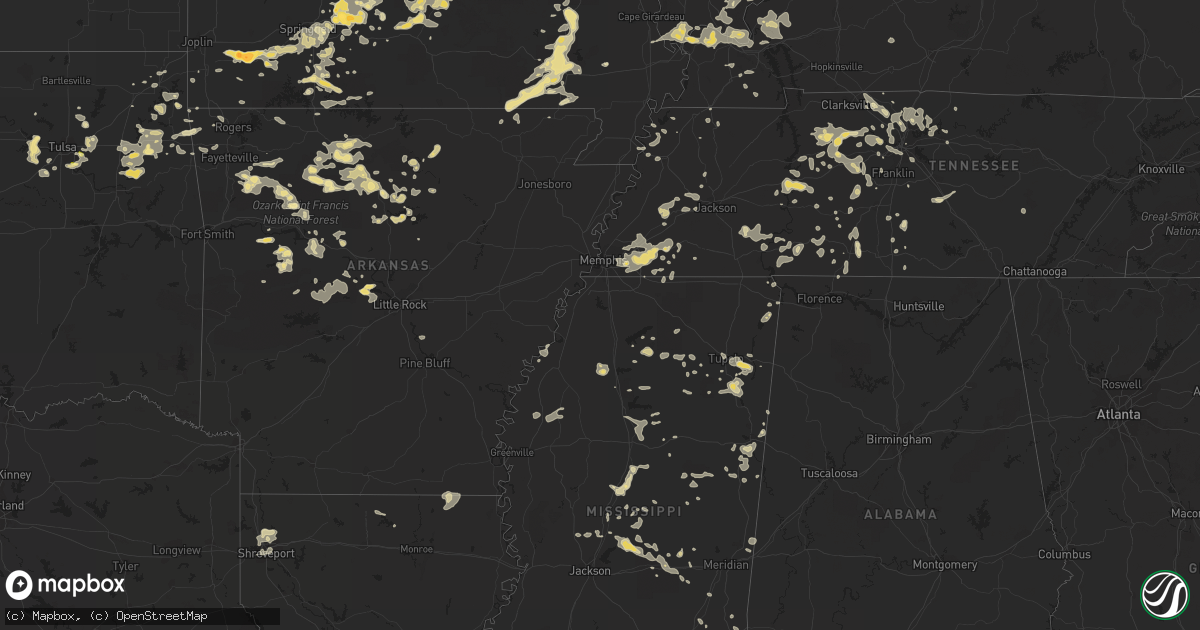
Hail Map in Kentucky on August 16, 2012
Get this storm
August 16 map
$229
one time, instant access
Download today. No call, no setup
Keep the $229
Bought the map and want the full workflow? Apply the entire $229 to a subscription within 7 days. None of it is wasted.
Every map, not just this one
This buys you this map. Subscription and you get every map we run, in the markets you choose from a few cities to whole states to nationwide. Plus real-time alerts the moment a storm fires.
Contact data
Name, contact info, occupancy, even credit band for addresses in the footprint. You go from where it hit to who to call.
Become the source they trust
Unlimited branding weather history reports on demand. You already have the documented answer ready for the property owner, and you are the one who showed up with it.
Property data and RoofTrace estimates
Pull up any address you have got, its value and the exact code rules for that jurisdiction, straight from One Click Code. Then RoofTrace estimates the squares, pitch, and roof value, priced the way you price.
Storm reports in Kentucky
Kentucky
| Date | Description |
|---|---|
| 08/15/20129:50 PM CDT | Downed power line blocking hwy 100 just west of franklin |
| 08/15/20129:45 PM CDT | Two trees blocking hwy 100 west of franklin |
| 08/15/20129:31 PM CDT | Thunderstorm winds removed a portion of a residents roof. Several trees were toppled in her yard. |
| 08/15/20129:20 PM CDT | A local report indicates 60 MPH wind near FRANKLIN |
| 08/15/20129:17 PM CDT | A local report indicates 63 MPH wind near BOWLING GREEN |
| 08/15/20129:17 PM CDT | Report of several trees down in bowling green. |
| 08/15/20129:05 PM CDT | Spotter reported twenty foot tall tree down...blocking bradshaw lane next to salem church road. Another tree down on salem church road near the intersection of bradshaw |
| 08/15/20129:00 PM CDT | *** 1 fatal *** strong winds associated with a thunderstorm toppled a tree onto the porch of a residence. A man sitting on this porch was killed. |
| 08/15/20128:55 PM CDT | Gust reported at u.s. Route 41a and fort campbell blvd. |
| 08/15/20128:53 PM CDT | Report near lovers lane and pennyrile parkway. |
| 08/15/20128:48 PM CDT | Christian county emergency management reported a semi tractor trailer had tipped over on interstate 24 at mile marker 72. Gracey fire and rescue were enroute to scene. |
| 08/15/20128:45 PM CDT | Tree down on car on adams mill road off of state route 139 north of cadiz. One person trapped...condition unknown. Emergency vehicles enroute. Report received 908 pm cd |
| 08/15/20128:45 PM CDT | Spotter report from near the trigg...christian county line around gracey. |
| 08/15/20128:45 PM CDT | Tree down on powerline across state route 139 south of cadiz. In addition...lightning started some trees on fire in the roaring springs area of the county. |
| 08/15/20128:21 PM CDT | Spotter heard branches breaking off trees...was without power at his location. |
| 08/15/20128:14 PM CDT | Trees down in the prospect and goshen areas |
| 08/15/20128:05 PM CDT | County road crews were dispatched to clear trees over state roads 810...93...295 and 819 all west of eddyville. |
| 08/15/20128:00 PM CDT | *** 1 fatal *** strong winds associated with a thunderstorm toppled a tree onto the porch of a residence. A man sitting on this porch was killed. |
| 08/15/20128:00 PM CDT | Trees down in the prospect and goshen areas |
| 08/15/20127:40 PM CDT | Large tree blocking lees lane and widespread downed tree branches. |
| 08/15/20127:35 PM CDT | Tree reported down on house in paducah near intersection of s 30th st and mississippi st. No details at this time. Called 911. |
| 08/15/20127:10 PM CDT | Late report from evening of aug 16. Emergency manager reports several small trees across roads and power lines down. Damage mostly on or near highway 1105 between barlo |
All States Impacted by Hail Map on August 16, 2012
Cities Impacted by Hail Map on August 16, 2012
- Maysville, AR
- Jay, OK
- Gravette, AR
- Carter, OK
- Lebanon, TN
- Pinckneyville, IL
- Cutler, IL
- Oxford, MS
- Taylor, MS
- Big Cabin, OK
- Calico Rock, AR
- Chouteau, OK
- Springdale, AR
- Fayetteville, AR
- Peggs, OK
- Locust Grove, OK
- Rose, OK
- Somerville, TN
- Attica, IN
- Williamsport, IN
- Hamel, IL
- Pocahontas, IL
- Highland, IL
- Aviston, IL
- Marine, IL
- Carlyle, IL
- Lebanon, IL
- Saint Jacob, IL
- Breese, IL
- Greenville, IL
- Edwardsville, IL
- Troy, IL
- Worden, IL
- Alton, IL
- Summerfield, IL
- Moro, IL
- Bethalto, IL
- Alhambra, IL
- Cottage Hills, IL
- East Alton, IL
- Trenton, IL
- Greenville, MO
- Houston, MO
- Raymondville, MO
- Licking, MO
- Hardeeville, SC
- Bluffton, SC
- Okatie, SC
- Neelyville, MO
- Enville, TN
- Henderson, TN
- Finger, TN
- Jacks Creek, TN
- Rincon, GA
- Salina, OK
- Spavinaw, OK
- Saint Elizabeth, MO
- Shreveport, LA
- Bossier City, LA
- Barksdale Afb, LA
- Bankston, AL
- Taylorville, IL
- Terre Haute, IN
- West Terre Haute, IN
- New Goshen, IN
- Villa Ridge, IL
- Barlow, KY
- Elkins, AR
- Winslow, AR
- Combs, AR
- Canton, MS
- Pana, IL
- Owaneco, IL
- Washington, IN
- Pierce City, MO
- Monett, MO
- Chandler, TX
- Salome, AZ
- Bentonia, MS
- Shubuta, MS
- Elida, NM
- Hagarville, AR
- Lamar, AR
- Winfield, IA
- Berryville, AR
- Eureka Springs, AR
- Lawrenceburg, TN
- Ethridge, TN
- Leoma, TN
- Cleveland, OK
- Sand Springs, OK
- Osage, OK
- Mannford, OK
- Prue, OK
- Jasonville, IN
- Clay City, IN
- Coal City, IN
- Witt, IL
- Jacksonville, IL
- Woodson, IL
- Murrayville, IL
- Franklin, IL
- Tishomingo, MS
- Iuka, MS
- Poplar Bluff, MO
- Collins, GA
- College Grove, TN
- Saint Peters, MO
- O'Fallon, MO
- Clarksville, AR
- Frohna, MO
- Perryville, MO
- Fox, AR
- Edgemont, AR
- Shirley, AR
- Grandin, MO
- Warm Springs, AR
- Williamsville, MO
- Doniphan, MO
- Ellsinore, MO
- Mill Spring, MO
- Harviell, MO
- Fairdealing, MO
- Gatewood, MO
- Clinton, IN
- Rockville, IN
- Rosedale, IN
- Marshfield, MO
- Quitman, TX
- Randolph, MS
- Pontotoc, MS
- Millstadt, IL
- East Carondelet, IL
- Saint Louis, MO
- Belleville, IL
- Dupo, IL
- East Saint Louis, IL
- Francesville, IN
- Marionville, MO
- Aurora, MO
- Lumberton, MS
- Columbia, MS
- Butler, AL
- Toxey, AL
- Assumption, IL
- Emelle, AL
- Ozark, MO
- Nixa, MO
- Camden, MS
- Sallis, MS
- Cornersville, TN
- Monticello, IN
- Otwell, IN
- Huntingburg, IN
- Jasper, IN
- Myrtle, MS
- Silva, MO
- Clubb, MO
- Annapolis, MO
- Fredericktown, MO
- Lobelville, TN
- Holladay, TN
- Sugar Tree, TN
- Saint Joe, AR
- Pindall, AR
- Everton, AR
- Eupora, MS
- Oark, AR
- Pettigrew, AR
- Ozone, AR
- Saint Paul, AR
- Chatham, IL
- Jenks, OK
- Tulsa, OK
- Broken Arrow, OK
- Bixby, OK
- Lucedale, MS
- Dana, IN
- Hillsdale, IN
- Montezuma, IN
- Dexter, MO
- Bloomfield, MO
- Kansas, OK
- Colcord, OK
- Watts, OK
- Rogersville, MO
- Omaha, IL
- Norris City, IL
- Broughton, IL
- Raleigh, IL
- Eldorado, IL
- Galatia, IL
- Bay Minette, AL
- Fairfield, IL
- Fort Stewart, GA
- Pep, NM
- Carlinville, IL
- Shipman, IL
- Western Grove, AR
- Melbourne, AR
- Mountain View, AR
- Okolona, MS
- Nettleton, MS
- Aberdeen, MS
- Couch, MO
- Des Arc, MO
- Naylor, MO
- Claremore, OK
- Roland, AR
- Bigelow, AR
- Gorham, IL
- Grand Tower, IL
- Jacob, IL
- Duck River, TN
- Williamsport, TN
- Hampshire, TN
- Primm Springs, TN
- Chesterfield, IL
- Medora, IL
- Paris, AR
- Dickson, TN
- Charlotte, TN
- Vanleer, TN
- Cumberland Furnace, TN
- Walshville, IL
- Sorento, IL
- Algodones, NM
- Stanley, NM
- Edgewood, NM
- Cerrillos, NM
- Sandia Park, NM
- Cocoa, FL
- Plato, MO
- Clinton, AR
- Bella Vista, AR
- Bentonville, AR
- Violet Hill, AR
- Brockwell, AR
- Franklin, AR
- Sulphur Springs, AR
- Noel, MO
- Erin, TN
- Verona, MO
- Wentworth, MO
- Savannah, GA
- Catherine, AL
- Thomaston, AL
- Arlington, AL
- Spencer, IN
- Freedom, IN
- Camargo, IL
- Tuscola, IL
- Baldwin, IL
- Evansville, IL
- Walsh, IL
- Sparta, IL
- Coulterville, IL
- Seabrook, SC
- Maryland Heights, MO
- Bridgeton, MO
- Saint Ann, MO
- Parthenon, AR
- Forest, MS
- Lake, MS
- Deer, AR
- Sainte Genevieve, MO
- Grove, OK
- Veedersburg, IN
- Salem, MO
- Thompsonville, IL
- Harrisburg, IL
- Ridgway, IL
- Bee Branch, AR
- Kincaid, IL
- West, MS
- Vaiden, MS
- Franklin, TN
- Bucyrus, MO
- Success, MO
- Muleshoe, TX
- Staunton, IL
- Dennard, AR
- Marshall, AR
- Leslie, AR
- Mount Judea, AR
- Portales, NM
- Fort Stockton, TX
- Springfield, IL
- Laquey, MO
- Roswell, NM
- Vallonia, IN
- Brownstown, IN
- Litchfield, IL
- Mount Olive, IL
- Butler, IL
- Hillsboro, IL
- Yemassee, SC
- Tupelo, MS
- Hartville, MO
- Chapmansboro, TN
- Tennessee Ridge, TN
- Fairview, TN
- Ashland City, TN
- Bon Aqua, TN
- White Bluff, TN
- Burns, TN
- Lyles, TN
- Cumberland City, TN
- McEwen, TN
- Cordova, TN
- Germantown, TN
- Memphis, TN
- Columbus, MS
- Petersburg, TN
- Frankewing, TN
- Pulaski, TN
- Heidelberg, MS
- Iowa Park, TX
- Electra, TX
- Uriah, AL
- Boyle, MS
- Cleveland, MS
- Miami, OK
- Hulbert, OK
- Sudan, TX
- Rogers, NM
- Wilsonville, IL
- Gillespie, IL
- Sawyerville, IL
- Bunker Hill, IL
- Stockton, AL
- Shannon, MS
- Ambrose, GA
- Waynesboro, MS
- Auburn, IL
- Estill, SC
- Walnut Shade, MO
- Branson, MO
- Reeds Spring, MO
- Crawford, MS
- Brooksville, MS
- Springfield, MO
- Scotland, AR
- Eucha, OK
- Paris, IL
- Waverly, TN
- Hornbeak, TN
- Jerseyville, IL
- Belle, MO
- Bland, MO
- Linn, MO
- Brookston, IN
- Remington, IN
- Pulaski, IL
- Yellville, AR
- Brazil, IN
- Vermilion, IL
- Centerton, AR
- Higden, AR
- Edinburg, IL
- Rochester, IL
- Clarkdale, AZ
- Jerome, AZ
- Houlka, MS
- Fairfield Bay, AR
- Morrisonville, IL
- Nokomis, IL
- Harvel, IL
- Oakland, TN
- Lewisburg, TN
- Seymour, MO
- Choctaw, AR
- Barnsdall, OK
- Cedarcreek, MO
- Protem, MO
- Kirbyville, MO
- Hollister, MO
- Rueter, MO
- Cairo, IL
- Tamms, IL
- Mounds, IL
- West Alton, MO
- Olivehill, TN
- Savannah, TN
- Russellville, AR
- Garnett, SC
- Abbeville, MS
- Plainview, AR
- Siloam Springs, AR
- Morton, MS
- Lena, MS
- Brandon, MS
- Kenton, TN
- Solo, MO
- Graff, MO
- Fort Leonard Wood, MO
- Roby, MO
- Waynesville, MO
- Huggins, MO
- Elk Creek, MO
- Falcon, MO
- Mountain Grove, MO
- Lynchburg, MO
- Lebanon, MO
- Cabool, MO
- Mason, TN
- Collierville, TN
- Rossville, TN
- Williston, TN
- Eads, TN
- Arlington, TN
- Buffalo, MO
- Long Lane, MO
- Fitzgerald, GA
- Columbia, TN
- Santa Fe, TN
- Poland, IN
- Bowling Green, IN
- Flagstaff, AZ
- Harrison, AR
- Heber, AZ
- Needham, AL
- Gilbertown, AL
- New Johnsonville, TN
- Alexander, IL
- New Berlin, IL
- Diana, TX
- Granby, MO
- Bell Buckle, TN
- Christiana, TN
- Grovespring, MO
- Niangua, MO
- Dow, IL
- Elsah, IL
- Grafton, IL
- Findlay, IL
- Bethany, IL
- Shelbyville, IL
- Clarksdale, MS
- Enterprise, MS
- Pachuta, MS
- Dyersburg, TN
- Seligman, AZ
- Havana, AR
- Corydon, IN
- New Salisbury, IN
- Ramsey, IN
- Albion, IL
- Grayville, IL
- Huntsville, AR
- Fowler, IN
- Earl Park, IN
- Porterville, MS
- Lauderdale, MS
- Strafford, MO
- Oakland, MS
- Pope, MS
- Enid, MS
- Batesville, MS
- Saint Charles, MO
- Vernon, AL
- Sulligent, AL
- Fulton, MS
- Plantersville, MS
- London, AR
- Dardanelle, AR
- Percy, IL
- Tillatoba, MS
- Rockaway Beach, MO
- Kissee Mills, MO
- Forsyth, MO
- Taneyville, MO
- Leesburg, GA
- Oakfield, GA
- Albany, GA
- Wheaton, MO
- Fairview, MO
- Exeter, MO
- Purdy, MO
- Parsons, TN
- Waverly, IL
- Afton, OK
- Brownsboro, TX
- Ben Wheeler, TX
- Solsberry, IN
- Collinsville, IL
- Granite City, IL
- Golden Gate, IL
- Kenansville, FL
- Saint Cloud, FL
- Wagoner, OK
- Springfield, GA
- Clyo, GA
- Newington, GA
- Ava, MO
- Bradleyville, MO
- Madison, KS
- Hartford, KS
- Hendersonville, TN
- Goodlettsville, TN
- White Castle, LA
- Divernon, IL
- Moscow, TN
- Ishpeming, MI
- Negaunee, MI
- Mellott, IN
- Crawfordsville, IN
- Hillsboro, IN
- Newtown, IN
- West Lebanon, IN
- New Richmond, IN
- Wingate, IN
- Waynetown, IN
- Covington, IN
- Terrell, TX
- Waynesboro, TN
- Joelton, TN
- Amory, MS
- Makanda, IL
- Carbondale, IL
- Vinita, OK
- Mount Vernon, IL
- Waltonville, IL
- Perryville, AR
- Houston, AR
- Duke, MO
- Newburg, MO
- Quitman, AR
- Atkins, AR
- West Salem, IL
- Mount Erie, IL
- Pickens, MS
- Santo Domingo Pueblo, NM
- Rosiclare, IL
- Golconda, IL
- Grand Rivers, KY
- Jasper, AR
- Causey, NM
- Tahlequah, OK
- Boonville, IN
- Tennyson, IN
- Enfield, IL
- Witts Springs, AR
- Ripley, TN
- Brownsville, TN
- Conway, MO
- Elkland, MO
- Brookport, IL
- Bone Gap, IL
- Cowden, IL
- Lakewood, IL
- Beecher City, IL
- Axis, AL
- Saraland, AL
- Creola, AL
- Satsuma, AL
- Arcola, IL
- Sarcoxie, MO
- Clever, MO
- Brookline, MO
- Crane, MO
- Republic, MO
- Stark City, MO
- Billings, MO
- Orlando, FL
- Belleville, AR
- Sapulpa, OK
- Sardis, TN
- Reagan, TN
- Twin City, GA
- Metter, GA
- Louisville, MS
- Denmark, TN
- Rockwood, IL
- Ava, IL
- Stonington, IL
- Bulpitt, IL
- Waggoner, IL
- Pawnee, IL
- Farmersville, IL
- Moweaqua, IL
- Palmer, IL
- Tovey, IL
- Perkinston, MS
- Vancleave, MS
- Hurricane Mills, TN
- Loami, IL
- Ludowici, GA
- Killen, AL
- Florence, AL
- Mansfield, MO
- Goodman, MS
- Durant, MS
- Timbo, AR
- Obion, TN
- Ridgely, TN
- Worthington, IN
- Bloomfield, IN
- Nebo, IL
- Hereford, TX
- Adrian, TX
- Hilliard, FL
- Kingsland, GA
- Saint Marys, GA
- Yulee, FL
- Argenta, IL
- Decatur, IL
- Glennville, GA
- Hinesville, GA
- Whites Creek, TN
- Nashville, TN
- Olmsted, IL
- Sigourney, IA
- Gentry, AR
- Bloomingdale, GA
- Pooler, GA
- Ozark, AR
- Collinwood, TN
- Metropolis, IL
- Paducah, KY
- Belfast, TN
- Chrisman, IL
- Bloomingdale, IN
- Cory, IN
- Universal, IN
- Edgar Springs, MO
- Bastrop, LA
- Hamburg, AR
- Neosho, MO
- Warwick, GA
- Carmi, IL
- Burnt Prairie, IL
- Dorsey, IL
- Atmore, AL
- Highlandville, MO
- Greenview, IL
- Washburn, MO
- Newton, MS
- Lawrence, MS
- Pelahatchie, MS
- Mount Carmel, IL
- Pryor, OK
- Oaks, OK
- Fort Gibson, OK
- Ironton, MO
- Mill Shoals, IL
- Athens, AL
- Benton, LA
- Mechanicsburg, IL
- Boligee, AL
- Little Rock, MS
- Decatur, MS
- Union, MS
- Little Rock, AR
- Paron, AR
- Fordland, MO
- Houston, MS
- Bloomington, IN
- Altus, AR
- Chestnutridge, MO
- Clifton, TN
- Purvis, MS
- Springfield, TN
- Mark, IL
- Granville, IL
- Hennepin, IL
- Pocahontas, AR
- Collinsville, OK
- Oologah, OK
- Herrin, IL
- Carterville, IL
- Simpson, IL
- Browns, IL
- Adams, TN
- Francisco, IN
- Oakland City, IN
- Chandler, IN
- Elberfeld, IN
- Haubstadt, IN
- Cynthiana, IN
- Princeton, IN
- Fort Branch, IN
- Evansville, IN
- Lynnville, IN
- Owensville, IN
- Poseyville, IN
- Louin, MS
- Plainfield, IN
- Clayton, IN
- Mooresville, IN
- Gallatin, TN
- Shelburn, IN
- Burna, KY
- Tiline, KY
- Eddyville, KY
- Fredonia, KY
- Smithland, KY
- Salem, KY
- Kuttawa, KY
- Marion, KY
- Devils Elbow, MO
- Lisman, AL
- Livingston, AL
- Jay, FL
- Carthage, MS
- Phil Campbell, AL
- Hohenwald, TN
- Omaha, AR
- Pleasant Plains, IL
- Virden, IL
- Thayer, IL
- Gore Springs, MS
- Duck Hill, MS
- Herrick, IL
- Oconee, IL
- Bonita, LA
- Jones, LA
- Wilmot, AR
- Celeste, TX
- Elkhart, IL
- Depauw, IN
- Tiptonville, TN
- Yantis, TX
- Sulphur Springs, TX
- Como, TX
- Bells, TN
- Florissant, MO
- Cedar Hill, TN
- Westfield, IL
- Daufuskie Island, SC
- Farmerville, LA
- Altenburg, MO
- Old Appleton, MO
- Jackson, MO
- Uniontown, MO
- Friedheim, MO
- Oak Ridge, MO
- Murfreesboro, TN
- Readyville, TN
- Ravenden Springs, AR
- Sparta, MO
- Lexington, AL
- Seligman, MO
- Bluejacket, OK
- Crossville, IL
- Hartsville, TN
- Cimarron, NM
- Webster, FL
- Steens, MS
- Lovington, IL
- Hammond, IL
- Atwood, IL
- Mount Juliet, TN
- Portland, TN
- Cottontown, TN
- White House, TN
- Greenbrier, TN
- Adamsville, TN
- Milledgeville, TN
- Saltillo, TN
- Bethel Springs, TN
- Morris Chapel, TN
- Chunchula, AL
- Eight Mile, AL
- Wilmer, AL
- Balmorhea, TX
- York, AL
- Loretto, TN
- Hurley, NM
- Charleston, IL
- Keota, IA
- Antioch, TN
- Norwood, MO
- Dale, IL
- Equality, IL
- Springerton, IL
- West Frankfort, IL
- McLeansboro, IL
- Macedonia, IL
- Hickory, KY
- Boaz, KY
- Oakland, IL
- Lerna, IL
- Kinderhook, IL
- Olds, IA
- Mount Pleasant, IA
- Princeton, IL
- Arlington, IL
- Malden, IL
- England, AR
- Seminole, AL
- Summers, AR
- Cisne, IL
- Buffalo, IL
- Mount Pulaski, IL
- South Fulton, TN
- Fairview Heights, IL
- Danville, IL
- Gadsden, TN
- Humboldt, TN
- Macon, MS
- Arthur, IL
- Clarksville, TN
- Wesley, AR
- Witter, AR
- Kissimmee, FL
- Lake Wales, FL
- Poulan, GA
- Sylvester, GA
- Sumner, GA
- Catoosa, OK
- Glenarm, IL
- Ashland, IL
- Humboldt, IL
- Mattoon, IL
- Mound City, IL
- Linden, TN
- Wayne City, IL
- Dahlgren, IL
- Williamsville, IL
- Sherman, IL
- Holliday, TX
- Rolla, MO
- Dill City, OK
- Town Creek, AL
- Leighton, AL
- Dover, AR
- Starks, LA
- Chesterfield, MO
- Spring Valley, IL
- Seatonville, IL
- Depue, IL
- West Paducah, KY
- Kevil, KY
- Ralph, AL
- Fosters, AL
- Buhl, AL
- Conehatta, MS
- Pegram, TN
- Fair Grove, MO
- Eddyville, IL
- Fayette, AL
- Corning, AR
- Westpoint, TN
- Hartselle, AL
- Summertown, TN
- Mineola, TX
- Culleoka, TN
- Kampsville, IL
- White Hall, IL
- Eldred, IL
- Pecos, TX
- Michigan City, MS
- Piedmont, MO
- Lindale, TX
- Kellyville, OK
- Mount Pleasant, TN
- Shepherdsville, KY
- Louisville, KY
- Brooks, KY
- Burlington, WI
- Demopolis, AL
- Winona, MS
- Grenada, MS
- La Center, KY
- Clarksville, MO
- Carrollton, IL
- Pearl, IL
- Rockbridge, IL
- Raymond, IL
- Ellery, IL
- Dade City, FL
- Ruleville, MS
- Doddsville, MS
- Drew, MS
- Shaw, MS
- Murray, KY
- Seneca, MO
- Goodman, MO
- Christmas, FL
- Townsend, GA
- Midway, GA
- Mantachie, MS
- Mooreville, MS
- Ratcliff, AR
- Idaville, IN
- Noxapater, MS
- Marble Falls, AR
- Cannelburg, IN
- Montgomery, IN
- Farmersburg, IN
- Danville, AL
- Robertsdale, AL
- Barnhill, IL
- Galena, MO
- Oldfield, MO
- Chadwick, MO
- Glen Carbon, IL
- Maryville, IL
- Dale, IN
- Harrisonburg, LA
- Jonesville, LA
- Corn, OK
- Hydro, OK
- Keenes, IL
- Illiopolis, IL
- Niantic, IL
- Johnsonville, IL
- Bismarck, IL
- Alvin, IL
- Milltown, IN
- Centerpoint, IN
- Lutts, TN
- Alba, TX
- Theodosia, MO
- Martin, TN
- Grantsburg, IL
- Belknap, IL
- Longview, TX
- Rose Bud, AR
- Guyton, GA
- Brooklyn, MS
- Thebes, IL
- Benton, MO
- Ullin, IL
- Calvert City, KY
- Scott City, MO
- Ledbetter, KY
- Grand Chain, IL
- Miller City, IL
- Olive Branch, IL
- Crandall, IN
- Sentinel, OK
- Gilbert, AR
- Cedar Crest, NM
- Tijeras, NM
- Mayfield, KY
- Riverton, IL
- Pikeville, TN
- Spencer, TN
- Kiefer, OK
- Melbourne, FL
- Newburgh, IN
- Water Valley, MS
- Coffeeville, MS
- Saint Rose, LA
- Mobile, AL
- Semmes, AL
- Hallsville, TX
- Kosciusko, MS
- Hemet, CA
- Tuscaloosa, AL
- Lenox, TN
- Calhoun City, MS
- Wiggins, MS
- Broxton, GA
- Phillipsburg, MO
- Spokane, MO
- Murphysboro, IL
- Lewis, IN
- Hickory, MS
- Weir, MS
- Calhoun, IL
- Parkersburg, IL
- Caledonia, MS
- Oreana, IL
- Rensselaer, IN
- Windsor, IL
- Marshall, IN
- Seymour, IN
- Lewisburg, KY
- Dunmor, KY
- Geff, IL
- Saint Robert, MO
- Hasty, AR
- Flippin, AR
- Vendor, AR
- Valley Springs, AR
- Marcella, AR
- Delaware, AR
- State Line, MS
- Centerville, TN
- Strasburg, IL
- Stewardson, IL
- McDavid, FL
- Bernice, LA
- Spearsville, LA
- Danville, AR
- Whatley, AL
- O'Fallon, IL
- Mascoutah, IL
- Godfrey, IL
- New Baden, IL
- Brighton, IL
- New Douglas, IL
- Alamo, TN
- Bingham, IL
- Ramsey, IL
- Fillmore, IL
- Irving, IL
- Russellville, AL
- Bluford, IL
- Tifton, GA
- Ashburn, GA
- Caruthersville, MO
- Adona, AR
- Hickory Valley, TN
- Saulsbury, TN
- Athens, IL
- Cantrall, IL
- Mount Auburn, IL
- Blue Mound, IL
- Cuba, AL
- Sandy Hook, MS
- Longville, LA
- Crump, TN
- Waldron, AR
- Waycross, GA
- Carbon, IN
- Vergennes, IL
- Mount Vernon, AL
- Stanton, TN
- Farmington, KY
- Kirksey, KY
- Benton, KY
- Trenton, TN
- Willow Springs, MO
- Richland, MO
- Wray, GA
- Poplarville, MS
- Lamar, MS
- Troy, TN
- Mountainburg, AR
- West Fork, AR
- Mims, FL
- Titusville, FL
- Patterson, MO
- Lodi, MO
- Pleasant View, TN
- Vardaman, MS
- Fayetteville, TN
- Ardmore, TN
- Taft, TN
- Isabella, MO
- Thornfield, MO
- Chester, IL
- Farrar, MO
- Elkville, IL
- Sedgewickville, MO
- Campbell Hill, IL
- Morocco, IN
- Statesboro, GA
- New Orleans, LA
- Fieldon, IL
- Rockledge, FL
- Broadview, NM
- Tucker, AR
- Talala, OK
- Millry, AL
- Thaxton, MS
- Ethel, MS
- Lexington, MS
- Byhalia, MS
- Decatur, AR
- Ackerman, MS
- Angel Fire, NM
- Hymera, IN
- Patricksburg, IN
- Coalmont, IN
- Philadelphia, MS


